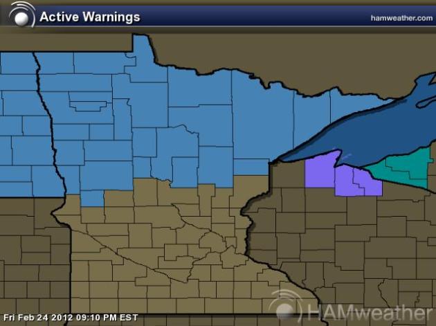
Todd's Conservation MN Outlook for the Twin Cities and all of Minnesota:
SATURDAY NIGHT: Breezy. Increasing clouds, chance of snow, mainly across central and northern Minnesota. Winds: SSE 10-20mph. Low: 22
SUNDAY: Mostly cloudy, and breezy. Storm system continues trending north, chance of a light rain/snow mix, but the heaviest snow will be across the northern third of Minnesota (6"+). Twin Cities could see a light coating. Winds: WSW 15-25mph. Low: 22. High: 39.
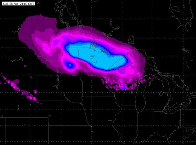
Sunday Storm
I'll have more detials below, but this is a look at the Sunday storm, which takes the heaviest snowfall across far northern Minnestoa. The Twin Cities gets very little snow if this verifies.
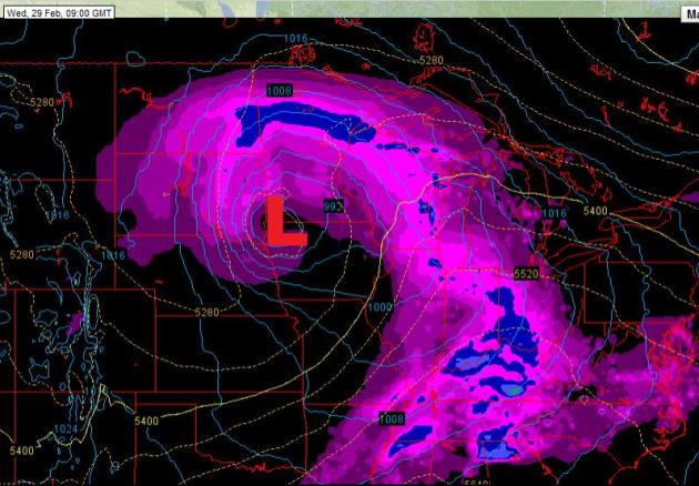
Winter Storm Watch
Timing: Sunday Morning to Monday Morning
Snowfall: 6" or More Possible

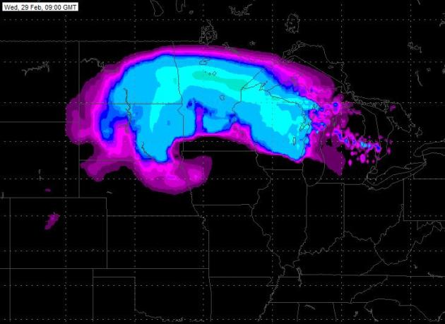
Snowfall Forecast
This is a glance at where the heaviest snow is going to fall with this first system. Note the northerly track, keeping most of the snow across the norther third of the state. Some spots could pick up 6" or more, especially along the north shore.

MONDAY: AM flurry or two, but generally a sunny start and lighter winds. Another system looks to be developing and heading up from the southwest. Another chance of snow overnight. Low: 18. High: 28.
WEDNESDAY: Windy, lingering clouds and snow showers. Heaviest snow once again across the northern third of Minnesota. Low: 10. High: 28.
Tuesday/Wednesday Storm Potential
This storm looks like it has some teeth too, in fact it could be a bit stronger. However, the models have been trending this storm north as well, puting the heaviest snowfall across the northern half of the state. Still a little too early to get excited about the exact deatails, but this one could be a doosey for some across the state.
THURSDAY: Not as windy. Partly sunny with a light snow chance. Low: 14. High: 30.
FRIDAY: Mix of clouds and sun. A few afternoon flurries. Low: 12. High: 27.
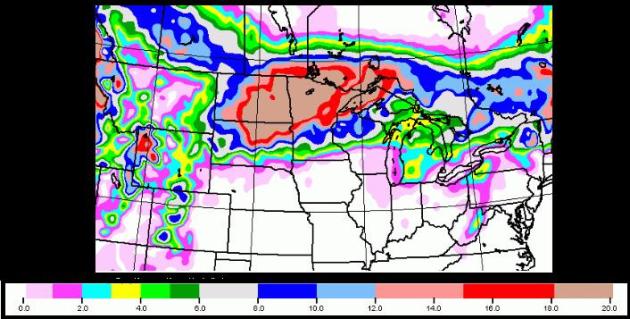
Snowfall Forecast
Take a look at the extended snowfall forecast through next week. Note, this image is depicting two storms, the Sunday/Monday sytstem and the Tuesday/Wednesday system, but I just about fell out of my chair when I saw this. Also keep in mind that it's still too early to get excited about specifics with the next storm. However, this is some of the most significant snow that models have picked up on this close to home this winter season. Keep in mind that models have trended this next system a little farther north in the past couple of runs and it's possible that this next storm (Tuesday/Wedensday) could eventually wind up spitting out all the heavy snow across the northern reaches of the state once again... Stay tuned! Again, the forecast will likely change over the coming days.
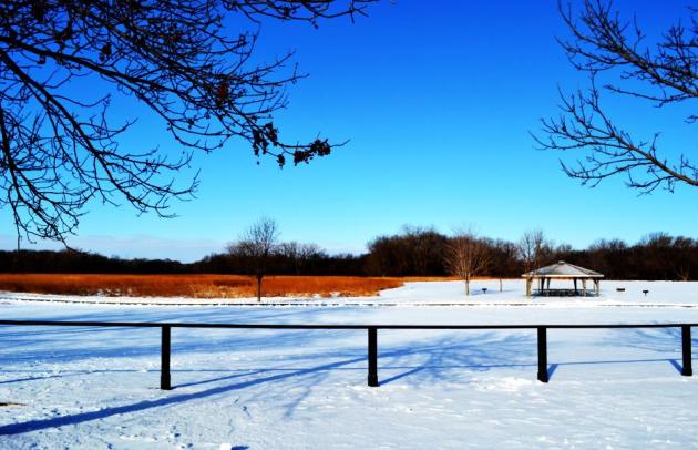
Picturesque Park
I snapped this shot yesterday morning from the NW Burbs. It was nice to see the sun for a bit, but it certainly felt more February-like with wind chill values in the teens.
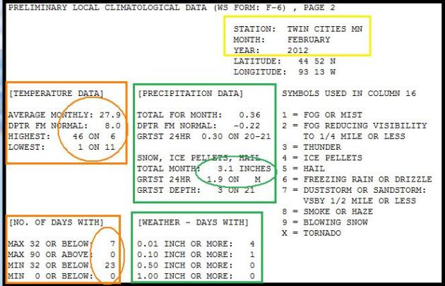
February by the Numbers
February statistics (through the 23rd) shows the average temperature hovering around 8 degrees above average, 1999 boasted similar numbers (finished 8 degrees above average) and is currently the 10th warmest February on record. There is a good chance that we could again sneak into one of the top 10 spots for the warmest February's on record. Other notable stats so far this month, we have only had 3.1" of snow, which is 3.1" below average snowfall for the month and still 21.7" below average snowfall for the season (since July 1st). The other notable stat is the number of days below zero, we have had none (coldest was 1F on the 11th, warmest day was 46F on the 6th), which according to NOW Data we average 6 nights at "0" degrees or colder. Interestingly, we have only seen 3 sub-zero nights the entire winter season, which according to NOW Data we average a little over 24 nights at "0" degrees or colder. If we don't see any more sub-zero nights this winter, we'll have had 2nd least number of sub-zero minimums since records began (1872-2012). The least number of sub-zero minimums was in 2000-01 at 2 times.
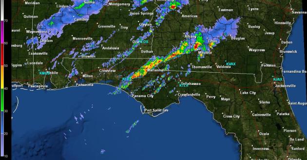
Not Exactly Beach Worthy
Spring-like weather has been showing up a little more across the nation this February. Weather forecasts across the northern tier of the nation call for snow showers, but down south it's thunderstorms. This was the radar on Friday afternoon from the panhandle of Florida, not exactly beach worthy.
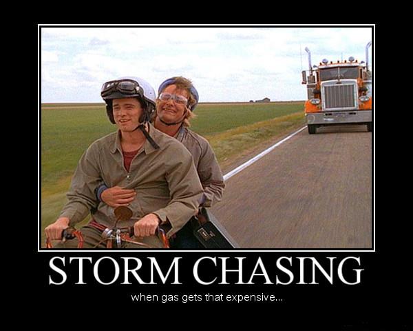
Thunderstorm Season is Storm Chasing Season
I enjoy storm chasing, but it sure is a tough profession. Pounding the pavement for thousands of miles, eating (mostly) fast food and spending time away from family is something that dedicated storm chasers will endure to chase after the ultimate prize of witnessing a supercell thunderstorm drop a tornado. I sure hope we don't start seeing more of this now that gas prices are so high!
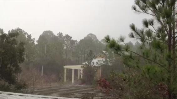
This Was The Scene From Walton County, FL
Cool frontal passage - severe storm warning was issued for 60 mph wind gust and pea-size hail. About .5" rain in 30 minutes. Not exactly beach-worthy!
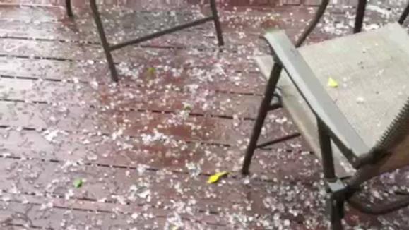
Ping-Pong Size Hail Near Augusta Georgia on Friday
Strong to severe thunderstorms rolled through parts of Georgia too.
In the 2nd half of the video, there's a nice clap and rumble of thunder... kind of makes me miss the Minnesota thunderstorm season!
High Season For Tornadoes Ahead, Eyes on the Southeast
Strong to severe thunderstorms rumbled across parts the eastern half of the nation on Thursday and Friday. The most active period for severe thunderstorm is right around the corner, but we've already had a fairly active 2012.
"With the month of March looming, tornado chasers are already watching the Southeast as a nasty storm brews with the potential to spin off a batch of tornadoes. But if funnel clouds develop Thursday or Friday as some forecasters believe, they won't be the first. This tornado season got an early and deadly start in late January when two people were killed by separate twisters in Alabama. Preliminary reports showed 95 tornadoes struck last month, compared with 16 in January during a particularly stormy 2011."
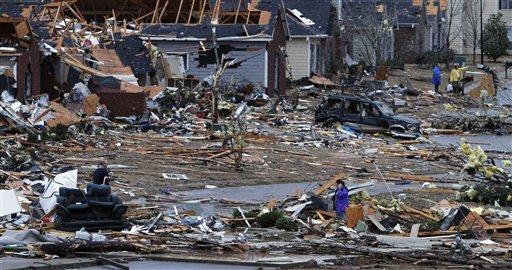
"In this Jan. 23, 2012, file photo, residents walk around through the debris of their neighborhood after a tornado ripped through the Trussville, Ala. area. Storm chasers are watching the Southeast as a nasty storm brews with the potential to spin off a batch of tornadoes. Tornado season is just about here and forecasters believe twisters are possible Thursday and Friday. But in reality, it got an early and deadly start in late January when two people were killed by separate twisters in Alabama. The season usually starts in March and then ramps up for the next couple of months, but forecasting tornado seasons is even more imprecise than predicting hurricane seasons. (AP Photo/Butch Dill)"
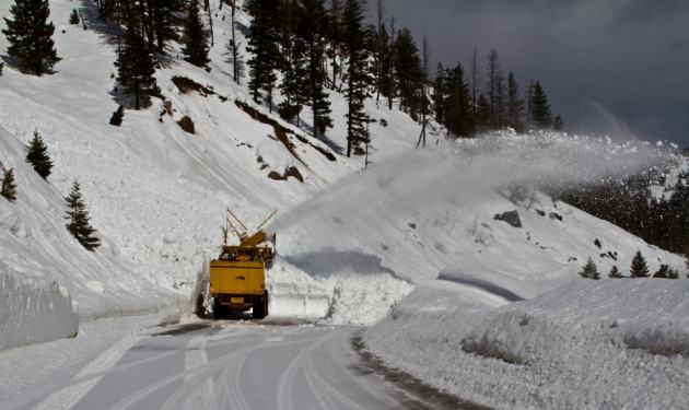
Unstable Snowpack Causes More Avalanches in the West and Another Fatality
A winter storm blasted through parts of the Northwest last week with up to 3ft. of snow in the mountains and category 3 hurricane force winds. Unfortunately, the combination of the two weather elements has created a very unstable snow pack. Another avalanche was triggered in Utah on Thursday, claiming the life of a snowboarding near The Canyons Ski Resort.

High Avalanche Danger
" During the last round of avalanche activity on Highway 21 between Grandjean Jct and Banner Summit, 13 slides came down, and two of those hit the highway, including one at least 20 feet deep. In all, 48 slides have come down on the road since Nov. 1."
Thanks for checking in, have a great weekend and don't forget to follow me on Twitter @TNelsonWNTV

-Meteorologist Todd Nelson-
No comments:
Post a Comment