46 F. high temperature in the Twin Cities Monday, 5 degrees shy of the all-time record of 51 in 1925.
26 F. average high for February 6.
29 F. high temperature a year ago in the Twin Cities, on February 6, 2011.
19.5" this winter at Midland, Texas. Source:
NOAA.
14.9" snow so far this winter in the Twin Cities.
36"+ snow at Sarajevo, capital of Bosnia. Details below. (AP Photo/Amel Emric)
300+ fatalities in Europe attributed to heavy snow and bitter cold in the last week.
Snow in Rome for the first time in 26 years.
-18 F. reported at Moscow, coldest in 60 years.
75,000 people have been admitted to 3,000 shelters across the Ukraine.
Trains shut down in northern Sweden. "Too cold to operate safely". Details
here.
"Cooper". Germany allows people or companies to sponsor the names of major winter storms, even cold fronts. The icy front responsible for hundreds of cold-weather-related fatalities has been nicknamed "Cooper" in local media. Go figure.
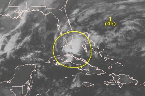
First February tropical storm since the Groundhog Day Storm of 1952? Details below.
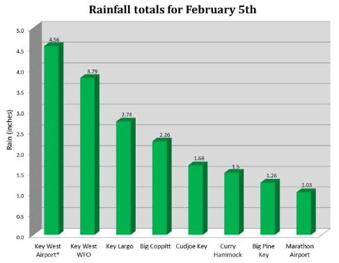
4.56" rain at Key West Sunday, wettest February day on record, and nearly 3 times the monthly rainfall average.
"
Everything great in the world is done by neurotics; they along founded our religions and created our masterpieces." - Marcel Proust. Image courtesy of
zazzle.com.
"Be very, very careful what you put into that head, because you will never, ever get it out." -Thomas Cardinal Wolsey (1471-1530)
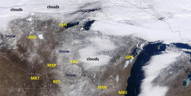
Where's The Snow? It's bad enough that Midland, Texas has seen considerably more snow than the Twin Cities (19.5" vs. 14.9" here in the metro area)...bad enough that Duluth has brown ground showing through on the 7th day of February, but it helps (a little) knowing that there's precious little snow
anywhere in the Upper Midwest. NASA's midday
MODIS satellite image shows a few patches of snow near St. Cloud and Alexandria....as well as just east of the MSP metro area across Wisconsin, but it's pretty bleak out there (for snow lovers).
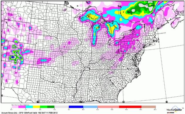
Nothing But Lake-Effect Snow. The GFS outlook through midday Saturday shows a few inches of snow downwind of the Great Lakes, but other than that, precious little accumulating snow east of the Rockies. The Great Snow Drought of 2012 limps on.
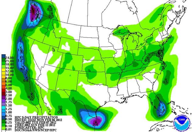
A Relatively Quiet Week. America has a chance to catch its breath this week - no large, widespread, organized storms in the forecast through the weekend. Heavy rain may soak south Texas with about 1" rain for south Florida, and heavy showers lashing the coast of California, as much as 1-2.5" rain for Washington State's Olympic Peninsula. Map courtesy of NOAA.
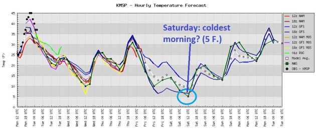
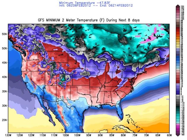
Glancing Swipes Of Cold Air. Not sure I'd call this "arctic", but Old Man Winter will get your attention, especially Friday and Saturday morning. Our lack of snow will limit how fall the mercury can fall - all models keep nighttime lows above zero later this week, bottoming out around +5 F. Saturday morning. A rapid recovery is likely over the weekend, temperatures thawing out again by Sunday and Monday of next week.
Staying Above Zero Later This Week? The map above shows the lowest temperature expected over the next 8 days, courtesy of
policlimate.com. Temperatures bottom out around 3-6 F. in the Twin Cities metro, subzero over roughly the northern half of Minnesota.
Hundreds Of Deaths As Europe Struggles With Snow Amid An Intense Cold Snap.
The New York Times has the latest on bitter air swirling across Europe. The USA has been very lucky this winter, in comparison: "
Extreme cold and heavy snow buried parts of Europe over the past few days, claiming the lives of hundreds of people, straining utilities in France, snarling transportation in Britain and leaving people in cities like Rome stymied. Eastern Europe was particularly hard hit. Ukraine’s Ministry of Emergencies reported that at least 131 people had died during a cold snap that has lasted more than a week in which night temperatures have dropped well below freezing. Hundreds have been treated for hypothermia or frostbite."
Photo credit above: "
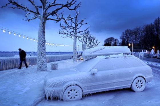
In this photo made available Monday, Feb. 6, 2012 a woman walks along an ice covered car on the iced waterside promenade at the Lake Geneva in Versoix, Switzerland, Sunday, Feb. 5, 2012. A cold spell has reached Europe with temperatures plummeting far below zero. (AP Photo/Keystone, Martial Trezzini)."
Keep The Ice Scrapers Coming! Details from
Yahoo News: "
A man walks past an ice covered car on the frozen waterside promenade at Lake Geneva in the Swiss city of Versoix. The deadly cold snap that has gripped Europe for more than a week wrought more havoc across the continent, straining emergency services, grounding flights and pushing the death toll past 300. (AFP Photo/Fabrice Coffrini)."
The Winter of All Or Nothing. We get stuck with the "nothing" part; meanwhile it's been snowing like there's no tomorrow in Montenegro. Details: "
People walk in the snow-covered street in downtown Cetinje, Montenegro, Sunday, Feb. 5, 2012. Across Eastern Europe, thousands of people continued to dig out from heavy snow that has fallen during a cold snap that struck more than a week ago and has killed hundreds of people. (AP Photo/Risto Bozovic)."
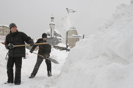
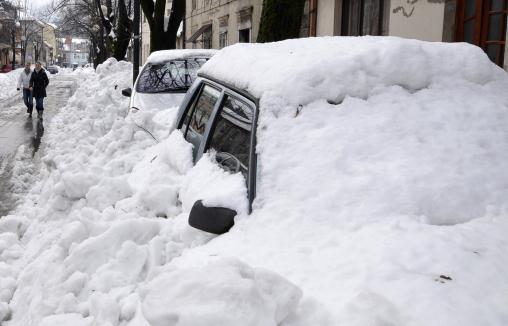
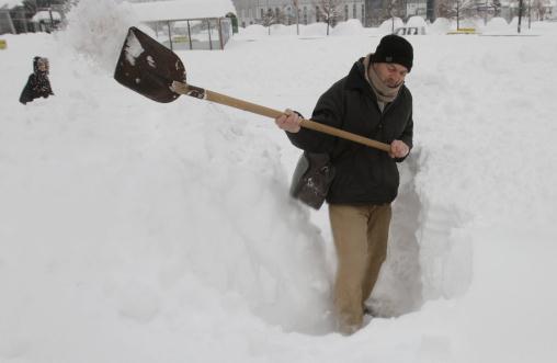
Buried In Snow. It's no exaggeration: tens of thousands of residents have become trapped in their homes, the result of 1-2
story drifts. Some of the photos coming out of eastern Europe are absolutely incredible: 3-4 feet of snow in many locations, trapping tens of thousands of residents in their homes. Details: "
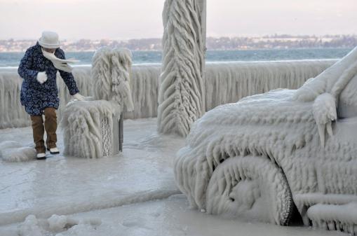
A Bosnian man shovels deep snow, to clean a path for pedestrians, in the Bosnian capital of Sarajevo, on Saturday, Feb. 4, 2012. Eastern Europe's unrelenting and deadly cold snap produced another heavy snowfall in the Balkans on Saturday, trapping people in their homes and cars, causing power outages, and closing airports, railway stations and bus services. In Bosnia, about 30 people whose vehicles were trapped in a tunnel south of Sarajevo called local radio stations to appeal for help, saying they had children with them and were running out of fuel. (AP Photo/Amel Emric)."
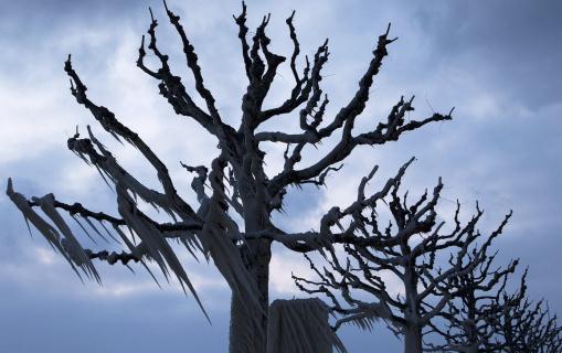
Icy Decorations. Not sure I've ever seen anything quite like this: freezing rain freezing up trees with daggar-like stalagmites of ice. Details: "
Ice hangs off trees on the shores of Lake Geneva, in Versoix, near Geneva, Switzerland, early Monday, Feb. 6, 2012. A cold spell is affecting large parts of Europe, with temperatures plummeting far below zero. (AP Photo/Keystone, Salvatore Di Nolfi)."
Europe Freeze Disrupts Schools, Transit. The story from AP and
MSNBC.com: "
Overwhelmed by deep snow and harsh temperatures, some countries in Europe closed down schools and struggled to run public transport Monday, as post-snow rains caused a dam to collapse in Bulgaria, flooding a village and killing at least four. Another four people were killed by floods in southern Bulgaria, and 10 people are missing, authorities said. Europeans across the continent were digging out from heavy snow after a week of bitter cold in which the number of dead — most of them homeless — continued to rise by the day. Temperatures have fallen as low as minus 33 Fahrenheit (minus 36 Celsius) in Ukraine, the hardest-hit country."
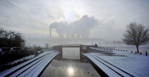
Photo caption above: "
Radcliffe on Soar Power Station is seen from a snow covered Trent Lock in Sawley, central England as much of Britain woke up to a blanket of snow after the big freeze grounded planes and caused road and rail disruption Sunday Feb. 5, 2012. (P Photo/Matthew Vincent/PA Wire)."
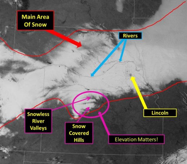
Snowy Swath. The National Weather Service has marked up the visible satellite image, showing the recent heavy snowfall across Nebraska. More details on their
Facebook page: "
This picture shows a satellite image on February 5th after a major winter storm impacted portions of Nebraska and Kansas. Snowfall totals near 12 inches were common in several locations. On satellite imagery it is interesting to see the total snow band as well as elevation effects and cities."
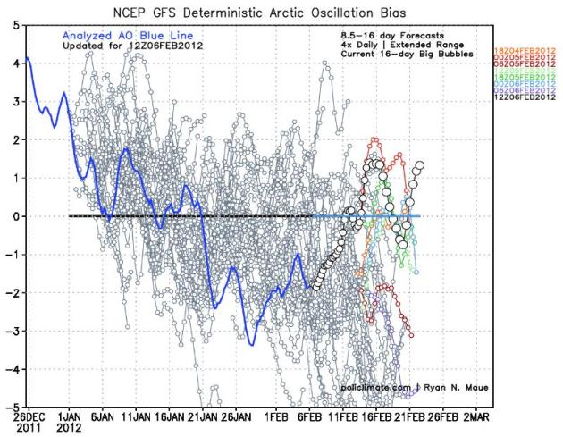
Change In The Weather? The AO (Arctic Oscillation) has been negative since January 21, meaning some easing of westerly winds (and a greater chance of bitter air penetrating south into the lower 48 states). Earlier it appeared like the AO might be trending negative in late February, but recent trends show an upward tick, hinting at a resumption of milder, Pacific winds for the latter half of February. We'll see a few (real) cold fronts, but nothing forbidding, no persistent subzero air is brewing. Graphic courtesy of
policlimate.com.
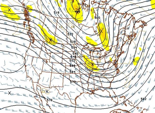
Seasonably Chilly - But Not "Arctic". We'll see more cold fronts in the coming months. Yep, you can take that forecast to the bank. The 500mb GFS forecast valid February 22 shows a west/northwest flow, with more Pacific than Arctic.
Third Week of February: Mostly 30s (Little Snow). I'm still waiting for something to point to on my weather maps. This dry, relatively mild pattern is nothing short of extraordinary. GFS Forecast above courtesy of NOAA.
Early For Tropical Disturbances. It's only February, yet things are heating up in the Gulf of Mexico. More details on record rains for the Florida Keys from NHC, the National Hurricane Center: "
A broad area of low pressure over the eastern portion of the Florida Straits is moving to the northeast near 15 mph. Strong upper-level winds will keep this storm system from developing into a subtropical cyclone. The area of low pressure was responsible for 4.34 inches of rain at Key West International Airport yesterday. This broke a 140 year record for maximum rainfall measured in Key West on February 5th. The previous record was 2.89 inches of rain, set in 1872. In addition, the 4.34 inches of rain measured yesterday at Key West International Airport set a record for wettest day ever in Key West during the month of February. Rainfall records at Key West date back to 1871."
* There has been only one recorded tropical storm during the month of February, in 1952. More details from
Wikipedia.
* The Washington Post has more on the unusually wet February for parts of south Florida
here.
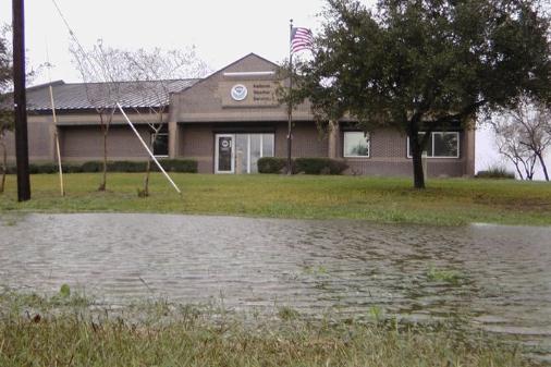
Texas Flooding. From the Corpus Christi office of the National Weather Service: "
Water Pooling in the front yard of the National Weather Service in Corpus Christi after receiving 2.72″ of rainfall."
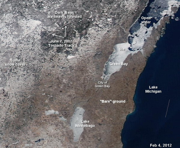
2007 Wisconsin Tornado Track Still Shows Up From Low-Earth Orbit. Thanks to Green Bay meteorologist for passing this one along, courtesy of
twitpic.com.
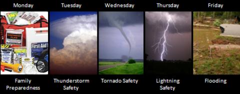
Severe Weather Awareness Week In Georgia. Things are heating up across the Gulf Coast;
NOAA has a few timely reminders: "
Severe weather is no stranger to the state. In 2011, there were 32 tornadoes across north and central Georgia, which ranks 3rd for the most number of tornadoes per year (1995-2011). As of February 1, 2012, three tornadoes have already occurred across the area. This week is the prime opportunity to learn about severe weather, actions to take when severe weather strikes and review your families preparedness plan as each day is dedicated to a different topic that addresses severe weather preparedness."
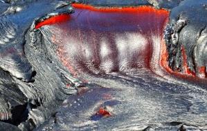
Amazing Photos From Kilauea Volcano. The story from
EarthSky.org: "
In early 2012, Stephen O’Meara of Volcano Watch International sent these images of lava flow on December 24, 2011 from Kilauea Volcano, the youngest and southeastern most volcano on the Big Island of Hawaii."
Sunshine Reduces Allergy, Eczema Risks In Children: Study. The story from nzherald.com.nz and
stumbleupon.com: "
Playing in the sunshine reduces the risk of children developing eczema and food allergies, researchers claim. Those living in areas with lower levels of sunlight are at greater risk of developing the conditions, their study found. Scientists used data from analysis of Australian children and how rates of food allergies, eczema and asthma varied throughout the country."
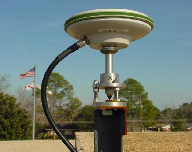 NOAA Improves GPS Accuracy.
 I had no idea.
NOAA reports: "
Did you know that Mt. McKinley in Alaska is still growing at a rate of about 1 millimeter per year due to continuous tectonic pressure? Or that Louisiana is losing up to 40 square miles of wetlands per year? To help scientists and others monitor our ever changing planet, NOAA manages a network of advanced GPS receivers know as Continuously Operating GPS Reference Stations (CORS) that helps them obtain highly accurate positioning information. These receivers help monitor even the minutest changes in the horizontal and vertical movement of the land across the U.S. and collect data that are used for a variety of other purposes. Knowing these changes enables scientists, engineers, land surveyors, and others to track subtle changes to the Earth’s surface — down to sub-centimeter levels." Photo above courtesy of NOAA.
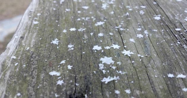
Is Each Snowflake Really Unique? The
Penn State Meteorology Department has the answer: "
Do you remember seeing your first snowflake? Maybe it was caught on your mitten, suspended atop the wool fibers so you could see every detail—graceful spires radiating from the center, so tiny and yet so intricately formed. Snow—whether a child’s snowman or a dirty snow bank along the roadside—is composed of millions of these miniscule masterpieces, each one different from the next. Or so we’ve been told. How do we really know that no two snowflakes are alike? Ask a meteorologist, and you may find that the snowflake’s fabled uniqueness is a matter of semantics."
"
The most violent element in society is ignorance." - Emma Goldman
More Than A Decade In, And Internet Comments Continue To Be Terrible. Yes, some Internet-trolls have nothing to do but vent (online) - saying things in the comment section they might hesitate saying (face to face). Who are these haters, and why do they have Internet priviledges?
The Atlantic weighs in on the current sorry state of web commentary: "
So many things about the Internet have become pretty awesome over the past decade or so, but there is one thing, however, that remains dysfunctional: comments. They continue to be terrible, and it's not only because of trolls and morons. Internet comments are hard to read and harder to engage with. Even in places with smart, thoughtful readers, the comment sections tend to be more like lists of unconnected ideas than genuine conversations. The problem is simply that it's hard to build a system that allows for smart ongoing conversations among large groups of people. It's a harder problem, fundamentally, than how to present and create good content."
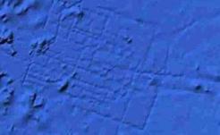
Google Earth Deletes Rumored Lost City Of Atlantis.
Mashable.com has the details: "
The lost city of Atlantis — rumored to be discovered in a Google Earth map — is once again lost, thanks to a maps update from the search giant. A grid-like pattern on a Google Ocean — a Google Earth extension — map raised speculation in 2009 that Google had discovered the sunken streets of the legendary city. However, considering the science, that seems highly unlikely. Overlapping data sets, which created the pattern many thought to be Atlantis, commonly occur in the sonar method oceanographers use to map the ocean floor. Scientists bounce sonar (sound) waves off the bottom of the ocean to measure its topography."
Can You Feel Tomorrow's Weather? Introducing The "Cryoscope". An interesting concept - now you can feel what tomorrow's temperature will be.
Gizmag.com has the story: "
Given that touch is generally the best way to determine how hot or cold something is - as long as it's not too hot or cold - Rob Godshaw has come up with a device that could provide a more immediately understandable representation of tomorrow's weather than the traditional abstract number coupled with simplified symbols seen on the nightly news. His invention is an aluminum cube called the Cryoscope that adds some haptic feedback to the daily weather forecast by letting users physically feel tomorrow's temperature - at least in their fingertips."
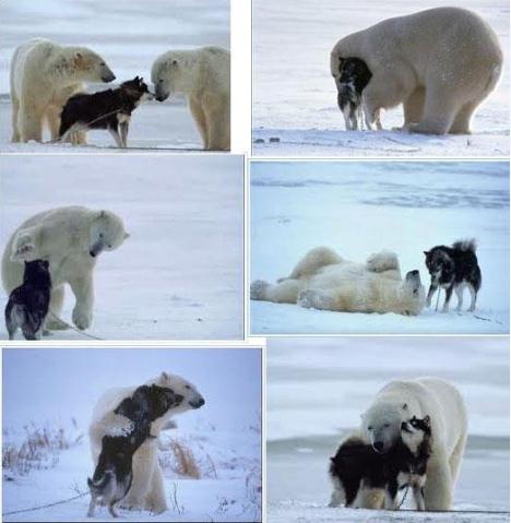
Photo Of The Day. O.K. Photo(s). Thanks to
stumbleupon.com for passing this one along. Very cute.
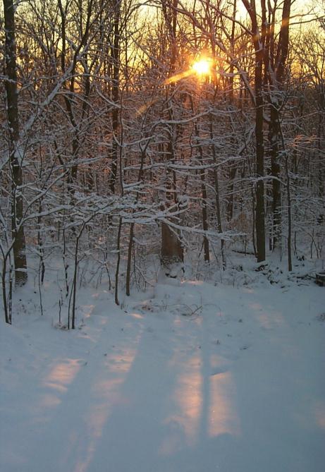
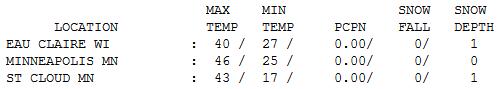
More March Madness. 46 on the 6th day of February? Not bad. Winds increased, our weekend inversion (finally) broke down, and the sun was able to come out, luring the mercury into the 40s across most of Minnesota. Highs ranged from 37 at Alexandria to 43 St. Cloud and 48 at Redwood Falls. St. Cloud, Eau Claire and Duluth all have 1" snow on the ground. Wow.
Paul's Conservation Minnesota Outlook for the Twin Cities and all of Minnesota:
TODAY: Patchy clouds, turning breezy and colder. Winds: N 10-15. High: 22 (wind chill from 5-15)
TUESDAY NIGHT: Clearing and plenty chilly. Low: 8
WEDNESDAY: Bright sun, seasonably cool. High: 26
THURSDAY: Clouds increase, a bit milder. Low: 17. High: 32
FRIDAY: Some sun, feels like February again. Low: 7. High: 15
SATURDAY: Blue sky, coats & parkas required. Low: 5. High: near 20
SUNDAY: Partly sunny, thawing out. Low: 11. High: 33
MONDAY: Flurries taper, March-like breeze. Low: 21. High: 34
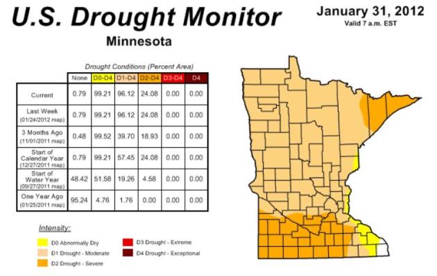
The Drought of 2012?
Let me preface my remarks by saying (out loud) that I hope I'm wrong. Confidence levels are low anytime one looks out beyond a few days. But watching the trends, a growing drought that started in Texas and expanded into the Upper Midwest, I have a hunch that drought may be the big weather story of 2012 close to home.
A dire lack of snow has lowered the spring flood threat but if this pattern lingers another 4-5 weeks there won't be much moisture for spring planting season. That MAY translate into more widespread brushfires, lower lake water levels, and a growing sense of paranoia for Minnesota's agricultural community.
Again, nothing is etched in stone (it never is), but a remarkably persistent La Nina will probably continue a mild, dry bias for the Upper Midwest into spring, maybe longer.
Short term, you get some mileage out of your heavy winter coat or parka. By Friday there will be NO doubt in your mind that its February, although a lack of snow on the ground may keep metro temperatures above zero. Any big storms will detour south of Minnesota (again), with highs in the 30s and 40s the 3rd week of February. Oh, we've picked up 75 minutes of sunlight since Dec. 21.
* Latest Minnesota Drought Monitor from NOAA
here.
"
A genius is one who shoots at something no one else can see - and hits it." - author unknown.
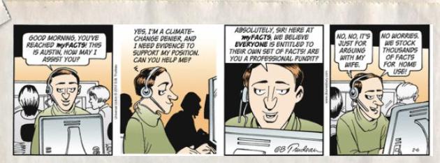
Climate Stories....
courtesy of
doonesbury.com.
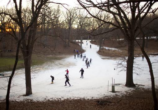
Climate Change Is Impacting Winter Sports. The story from
NRDC, the National Resources Defense Council: "
So far, it hasn’t been a great winter for skiers, snowboarders, snowmobilers and folks who depend on a lot of snow for their recreation and livelihood. Some states—Washington and Alaska—and some ski areas like Taos in New Mexico, and Telluride in southern Colorado, have gotten dumped on. But most resorts across the country are hurting for snow and hurting for dollars as a result. (See my colleague Kelly Henderson’s recent blog post on this topic). Some people have been arguing that this is just a normal fluctuation that comes with El Nino and La Nina weather patterns as well as the position of the jet stream, and that a warming climate has nothing to do with it. You can see evidence of this in the comments in response to Kelly’s blog." Photo courtesy of The Star Tribune.
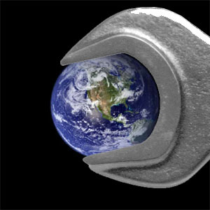
Bill Gates Backs Climate Scientists Lobbying For Large-Scale Geoengineering. The Guardian has more: "
A small group of leading climate scientists, financially supported by billionaires including Bill Gates, are lobbying governments and international bodies to back experiments into manipulating the climate on a global scale to avoid catastrophic climate change. The scientists, who advocate geoengineering methods such as spraying millions of tonnes of reflective particles of sulphur dioxide 30 miles above earth, argue that a "plan B" for climate change will be needed if the UN and politicians cannot agree to making the necessary cuts in greenhouse gases, and say the US government and others should pay for a major programme of international research."
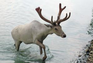
How Climate Change Leaves Arctic Caribou Out In The Cold. The Edmonton Journal has the story: "
University of Alberta biologist Isla Myers-Smith and her colleague were taking down their research camp in the Ruby Mountain Range when a snowstorm with winds of near hurricane force blew down their tent and sent their electric generator tumbling down a hillside. For nearly three days, Myers-Smith and Helen Wheeler hunkered down, eating what little food they had and watching nervously as the batteries of their satellite phone got weaker and weaker. Hungry and uncomfortable, they couldn't even sleep because their battered tent was constantly flapping in the wind."
Did Al Gore Polarize The Climate Debate? Think Progress has the story: "
A must-read study published Monday in the journal Climatic Change debunks some pervasive myths about public opinion and climate change. The lead author, Dr. Robert J. Brulle of Drexel University, gave me an exclusive interview. Stanford’s Jon Krosnick told me this paper was an “exciting contribution to the growing literature in this area.” He said, “the results he produced line up very closely with the results of our surveys and with my thinking on the issue, with a couple of caveats,” which I discuss below. He believes, “this paper represents a terrific amount of excellent work and is a great contribution to the literature using a well-established method.”
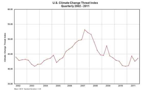
Caption for graphic above: "
The Climate Change Threat Index (CCTI) aggregates data from 6 different polling organizations gauging how much people worry about global warming."
 Ocean Stored Significant Warming Over Last 16 Years
.
NOAA has the details: "
The upper layer of the world’s ocean has warmed since 1993, indicating a strong climate change signal, according to a new study. The energy stored is enough to power nearly 500 100-watt light bulbs per each of the roughly 6.7 billion people on the planet continuously over the 16-year study period “We are seeing the global ocean store more heat than it gives off,” said John Lyman, an oceanographer at NOAA’s Joint Institute for Marine and Atmospheric Research, who led an international team of scientists that analyzed nine different estimates of heat content in the upper ocean from 1993 to 2008."


No comments:
Post a Comment