Todd's Conservation MN Outlook for the Twin Cities and all of Minnesota:
TUESDAY NIGHT: Rain, sleet, snow and freezing rain The heaviest snow once again looks to be setting up to our north, this time across central Minnesota. Winds: NNE 10-20mph Gusts to 35mph. Low: 30
WEDNESDAY: Windy with the wintry mix changing back over to snow showers. A light coating up to 2" of slush possible by late afternoon. Winds: Turning WNW 10-20mph. High: 34.
THURSDAY: A little more sun, not as windy. Low: 20. High: 33.
FRIDAY: Sun and cloud mix. Chance of light snow, mainly north . Low: 24. High: 34.
SATURDAY: Lingering flurries and snow showers. Low: 18. High: 29.
SUNDAY: Clipper rolls through, chance of snow. Low: 14. High: 33.
MONDAY: More sun and warmer. Low: 22. High: 40
In an attempt to keep updates more regular leading up to the midweek event, here is a look at the latest computer runs... Things, as expected, continue to change and they will continue to change by the time the storm actually hits PM Tuesday into Wednesday.
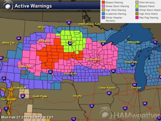
Watches & Warnings
We're starting to see the watches begin upgraded to warnings. Some of the blizzard watches across South Dakota have been upgraded to blizzard warnings... more warnings to come.
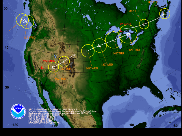
12Z Runs Trending Farther North
This is a look at the storm track moving up from southern California today. This type of track (moving up from the southwest) is the kind of storm that generally brings tons of moisture!
Water-logged Storm
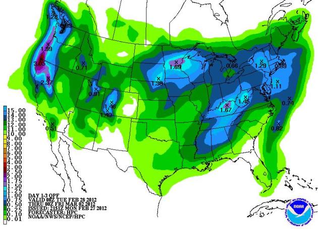
Regardless of what type of precipitation we get, it is looking like we will get some substantial moisture with this storm. In fact, some of us will get some of the heaviest amounts of liquid precipitation in a single day since (MSP Airport):
Last 0.50" was: October 12th when we had 0.54" of liquid
Last 0.75" was: August 1st when we had 0.84" of liquid
Last 1.00" was: July 16th when we had 1.06" of liquid
Last 1.50" was: July 15th when we had 1.82" of liquid
The image below is the precipitation forecast from AM Monday - AM Wednesday, note the maximum near MSP at 1.69" liquid!
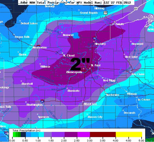
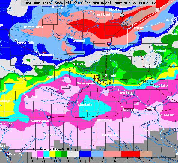
12Z NAM More Aggressive With Precipitation
The 12Z NAM is certainly more agressive with the amount of precipitation it is spitting out with around 2" total through the entire storm (NOT ALL SNOW). Keep in mind that some of this will mix in with sleet, freezing rain and rain for some spots.
18Z NAM Brings in More Rain Than Snow for MSP
If I took the 12Z NAM literally, it would have given MSP 1" to 2" of snow Tuesday, then around 0.10" of ice around the Tuesday evening commute with it changing to rain overnight (accumulating around 1.75" of rain), then back to a little snow on Wednesday, maybe another 1"... If that's the case, folks in the Twin Cities could ditch the shovels and start building an Ark! The 18Z NAM takes the heaviest snow even farther north than what the 12Z run had earlier.
Note the heaviest snow band setting up from Aberdeen, SD to Brainerd, MN to Duluth, MN and along the North Shore. The Twin Cities only gets clipped with a slushy, sloppy couple/few inches.
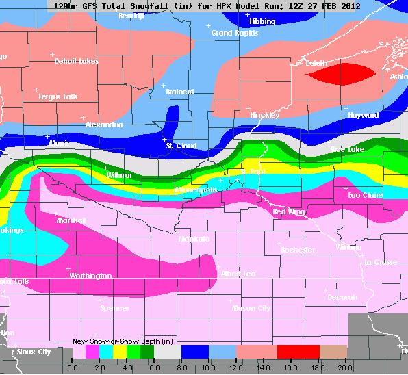
12Z GFS Shoves Heaviest Snow North As Well
This 12Z GFS is also showing a northerly track in the heaviest snow band, bringing more rain into the Twin Cities rather than snow.
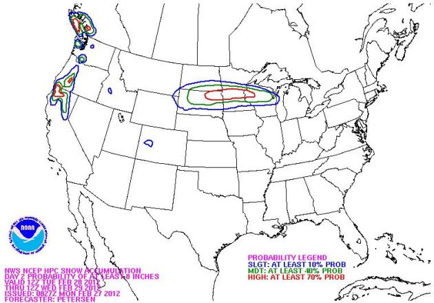
Probability of 8" of snow
The map below shows the HPC's probablitily of 8" of snow. The red indicates a HIGH probability (at least 70%)
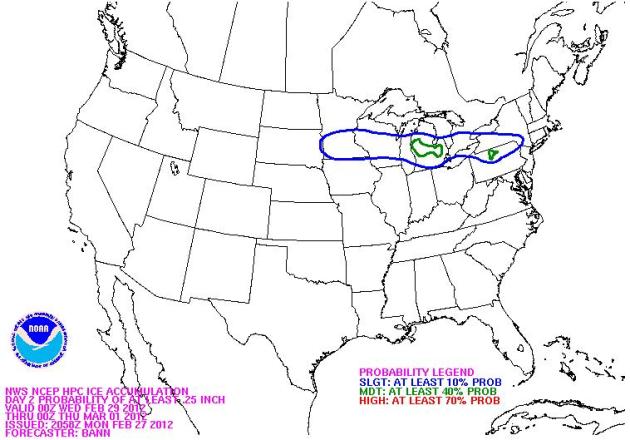
Freezing Rain Potential
The southern flank of main surge of moisture could fall as freezing rain. In fact, the freezing rain potential of at least 0.25" of ice is SLIGHT at 10%. I see a higher likelyhood of lighter amounts (0.10" of ice) more likely (Including the Twin Cities).
Stay tuned for further updates! This storm will still have significant impacts Tuesday through Wednesday.
More updates from Paul Douglas & I to come.
Don't forget to follow me on Twitter @TNelsonWNTV

-Meteorologist Todd Nelson-
No comments:
Post a Comment