Todd's Conservation MN Outlook for the Twin Cities and all of Minnesota:
MONDAY NIGHT: Clouds thicken, snow develops by daybreak Tuesday. Getting breezy. Winds: ESE 10-20mph. Low: 22
TUESDAY: Second storm blows in. Windy with snow early, then changing to a wintry mix, maybe even rain. (2" to 4" of snow possible, before sleet & wintry mix by the evening commute. Winds: E 15-30mph Gusts to 40mph. High: 34.
TUESDAY NIGHT: Snow likely (heavy at times with blowing and drifting, another 6"+ possible). The heaviest snow once again looks to be setting up to our north, this time across central Minnesota. Winds: NNE 15-30mph Gusts to 40mph. Low: 27
WEDNESDAY: Windy with the heaviest snow done by the daybreak. Lingering flurries and snow showers through the day, another light coating possible Winds: WNW 15-30mph. High: 33.
THURSDAY: Sunnier and not as windy. Low: 15. High: 33.
FRIDAY: Mostly cloudy with a chance of snow. Low: 22. High: 33.
SATURDAY: Lingering flurries and snow showers. Low: 16. High: 28.
SUNDAY: More sun, not as wild. Low: 16. High: 32
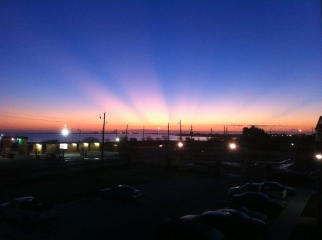
Texas Sunrise on Sunday
The picture below was from the National Weather Service out of Corpus Christie, a beautiful shot from Oso Bay Sunday morning. See their Facebook Page HERE:
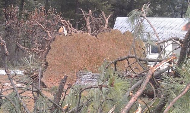
Massive Winds in Montana
Last weeks winter storm not only boasted several feet of snow in mountain, but is also brought crazy winds. This was some of the damage from Montanta courtesy the National Weather Service out of Missoula, see their facebook page HERE:
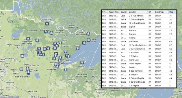
Sunday's Snow Across Northern Minnesota
Take a look at some of the snowfall reports across northern Minnesota. The most I could see was 10" from Two Harbors and Grand Rapids.
Have You Ever Heard of Brown Snow?
This is kind of interesting, look at this picture from Holyoke, MN... IT'S BROWN SNOW! There were a number of reports from Sunday's snow event that it was brown due to a dust storm from the Plains being sucked up into the storm.
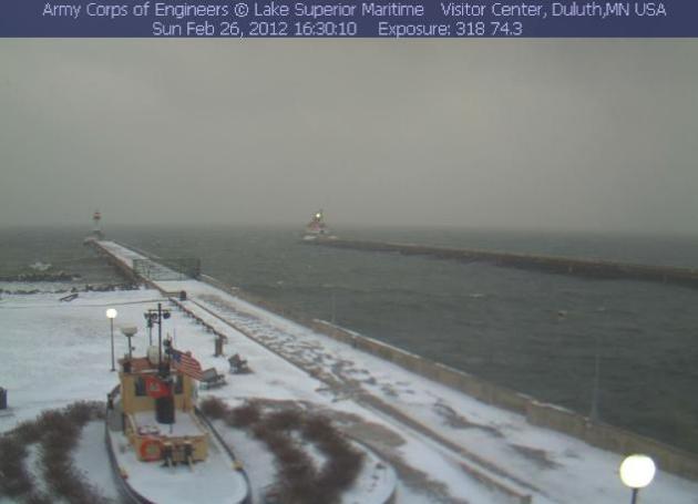
This was the scene from Duluth (Canal Park) yesterday.
Next Storm For Tuesday/Wednesday
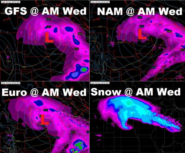
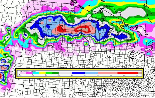
This storm looks like a doosey for parts of Minnesota (especially central Minnesota) This is a look at the storm system from the NAM, GFS and Euro. They all seem to have the placement of the low fairly close each other in southern Minnesota by the early morning hours of Wednesday. They heaviest of the snow looks like it will come through Tuesday and Tuesday night, it will shift into central and northern Minnesota and Wisconsin through Wednesday.
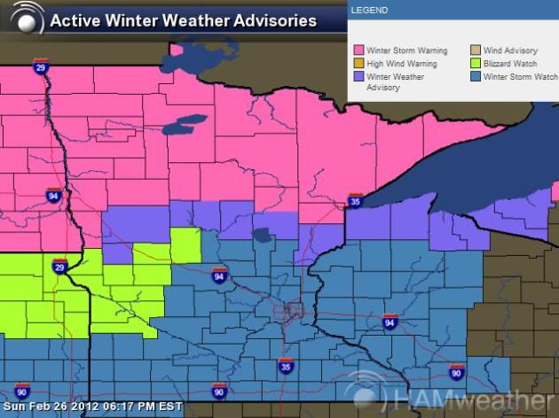
Blizzard Watches Up For Parts of the State
Here is a look at the winter weather headlines from the National Weather Service. The lime green color is a BLIZZARD WATCH in effect from Tuesday afternoon through Wednesday afternoon. If this storm stays on track with current forecasts... travel is going to be very bad if not impossible in spots. Stay tuned!
18Z Update
Paul Douglas and I will have several updates from now until the storm, but here's a look at the 18Z NAM, which shows the storm sagging south just a bit, but the heaviest is shifting a little farther east into Wisconsin.
18Z GFS
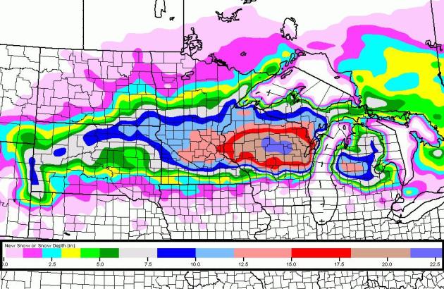
This is a look at the GFS thru midday Wednesday, which also shows a significant snow swath across central Minnesota.
Stay Tuned for further updates!
Don't forget to follow me on Twitter @TNelsonWNTV

-Meteorologist Todd Nelson-
No comments:
Post a Comment