Todd's Conservation MN Outlook for the Twin Cities and all of Minnesota:
TUESDAY NIGHT: Partly cloudy and quiet. Winds: WSW 5-10mph. Low: 25
WEDNESDAY: Another clipper arrives later, scattered light snow showers. Coating possible. Winds: WSW 5-15mph. Low: 25. High: 39
THURSDAY: Mostly cloudy with more light snow late. Winds: WNW 10-15mph. Low: 26. High: 36
FRIDAY: Cloudy with flurries. Chilly. Feels like February again. Low: 22. High: 29
SATURDAY: Chilly start, clouds thicken through the day and light snow develops late. Turning breezy. Low: 14. High: 28.
SUNDAY: Cloudy with a chance of snow. Low: 17. High: 26.
MONDAY: Partly sunny and colder. Low: 11. High: 21.
Snow Drought Areas Getting Snow This Week
For all the winter lovers out there in the Upper Midwest, get ready for some snow! Our first round of snow will continue moving through parts of Minnesota and Wisconsin through early Tuesday. Winter Weather Advisories have been issued for spots along the international border until late Tuesday, where a total of 3″ to 5″ of snow may be possible. Again, this is our first system this week, more snow chances to come!

MN Snow Forecast - System #1 (Monday Night-AM Tuesday)
Weather models leading up to the snow actually falling across the eastern portions of North and South Dakota, across part of Minnesota and Wisconsin showed the heaviest accumulations mainly across northwestern Minnesota where 3" to 5" would be possible. Locations near the Twin Cities would get lighter amounts, but would be enough to snarl up those morning commutes on Tuesday as many get back to work and school.

Additional Storms This Week
The upper level vorticity map, which shows areas of disturbed weather, show 3 different systems that could possibly bring inclement weather to the middle part of the country through the end of the week. System #2 is much weaker, but could bring in some light accumulations across the area later Wednesday into Thursday. A much larger storm system is still progged to move in by Sunday. This one is the one to watch as models have consistently put a heavier snow potential across parts of the Upper Midwest.

Snow Meteogram
This is a different look at the snow potential, here is shows the accumulating snow potential through the weekend. Note the 3 different snow chances with the biggest snow event (at this point & will likely change) occuring over the weekend.

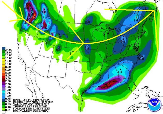
5 Day Precipitation Forecast
The 5-day precipitation forecast shows another dose of heavy rain across the Deep South through the week, but a majority of the nation’s precipitation will fall across the northern half of the nation through the end of the week.
Extended Snow Forecast
The longer range GFS forecast model has several inches of snow forecast to fall across the northern third of the nation through the end of the week… Keep in mind that this forecast is likely to change, but folks in the northern tier of the nation, who up until now haven’t had a whole lot of wintry weather, will likely get more snow this week than what we’ve seen in the past several weeks!

Easing the Drought
The good news here is that we are easing the drought quite a bit in the Deep South where SEVERE and EXCEPTIONAL drought conditions have been in place for several weeks/months.

Mardi Gras on Tuesday
Mardi Gras is on Tuesday (Fat Tuesday) the day before Lent and the forecast for New Orleans calls for cloudier conditions, but it still looks mild with temps around 70F.

Extended Forecast

Q&A:
This question comes from Joan Heinamen, she asks:
"What day will the sun reach 45 degrees on the horizon at zwip code 55066?"
It took me a little while to find these neat websites, but here you go Joan!
http://www.esrl.noaa.gov/gmd/grad/solcalc/
It appears that the sun will be at an elevation of 45 degrees in Red Wing, MN on March 19th at 12:55PM (and 32 seconds) and doesn't go back below 45 degrees until 1:40pm (and 23 seconds). It reaches a maximum height of 45.27 degrees at solar noon on the 19th, which occurs roughly around 1:17pm.
Here is another neat website:
http://www.timeanddate.com/worldclock/astronomy.html?n=159&month=3&year=2012&obj=sun&afl=-11&day=1
This one is not quite as precise and doesn't have as many cities, but it has a nice layout. It shows that the sun will reach an elevation of 45 degrees by March 20th at Minneapolis. At that point, we'll almost have 12 hours and 11 mintues of daylight. On Tuesday, February 21st, we will have nearly 10 hours and 44 minutes of daylight with sun elevation of 34.5 degress at solar noon, which occurs at 12:24pm.
Thanks for the question Joan!

Thanks for checking in, have a great rest of your week!
Don't forget to follow me on Twitter @TNelsonWNTV

-Meteorologist Todd Nelson-
No comments:
Post a Comment