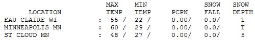
60 F. high in the Twin Cities Tuesday. Wow. I thought the 2" snow on the ground would keep the mercury from rocketing this high, but a southwest breeze was strong enough, and that snow at MSP International Airport melted rapidly.
April 20. The average high for April 20 in the Twin Cities is 60.
36 F. average high for March 6.
69 F. record high for March 6 (2000).
30 F. high temperature a year ago, March 6, 2011.
0" snow depth at KMSP as of 7 pm yesterday.
22.1" winter snowfall, to date.
78.3" snowfall last winter as of March 6 (source:
NOAA).
How Warm? All Bets Are Off. Now that MSP has lost much of its snow (I realize there's still a few inches northern and western 'burbs) the sun's energy will be able to go into heating up the air, not melting snow. The ECMWF brings the mercury into the mid 50s Saturday, slightly cooler Sunday (best chance of rain east of MSP over Wisconsin), before taking off into the mid 50s Monday, upper 50s Tuesday, and an almost incomprehensible 22 C next Wednesday. That's 71.6 F. I know, I don't believe it either, but at the rate we're surging into an early spring? I wouldn't rule anything out.
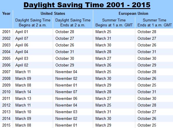
"Spring Forward". We all lose an hour of sleep this weekend. Daylight Saving Time kicks off at 2 am Sunday morning. Don't forget to set your clocks ahead one hour before going to be Saturday night. Another sure-fire sign of spring!
14 freezes for Dallas this past winter, a record for fewest on record. Photo credit
here.
12.41" rain for Dallas this winter, second wettest La Nina winter on record.
54 mph wind gusts in Chicago on Tuesday.
68 F. high at O'Hare Airport, 2 degrees away from a record. 25 degrees above average. Warmest since Nov. 13.
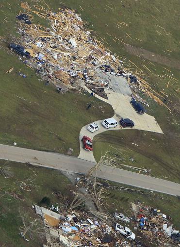
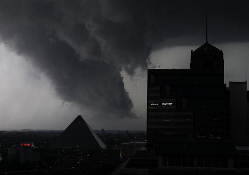
$2 billion. Estimated cost of last Friday's tornado outbreak (source: Eqecat).
Photo credit above: EF-4 strength tornadoes are capable of "scraping well-constructed brick/stone/timber homes down to bare foundation". Such was the case in Henryville, Indiana. Details: "
In this aerial photo, people inspect a demolished home Saturday, March 3, 2012, near Henryville, Ind., after a tornado swept through the town Friday. A string of violent storms demolished small towns in Indiana and cut off rural communities in Kentucky as an early season tornado outbreak killed more than 30 people, and the death toll rose as daylight broke on Saturday's search for survivors.(AP Photo/Al Behrman)."
"
According to some climate scientists, such earlier-than-normal outbreaks of tornadoes, which typically peak in the spring, will become the norm as the planet warms. "As spring moves up a week or two, tornado season will start in February instead of waiting for April," said climatologist Kevin Trenberth of the National Center for Atmospheric Research. - from an article below focused on climate change's possible impact on tornado season.
"
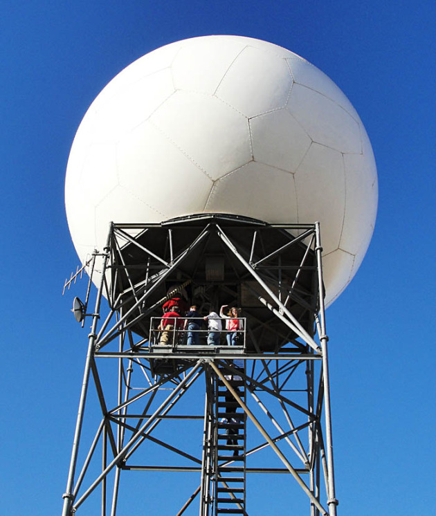
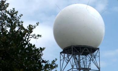
The entire United States network of 160 radar sites, including Alaska, Hawaii, Puerto Rico and Guam will be upgraded by early 2013 at a cost of about $50 million." - from an article on "dual-polarization" Doppler radar upgrades underway at NWS sites around the USA; details below.
U.N. Says 2011 Disasters Were The Costliest In History, With A Minimum Pricetag Of $380 Billion.
The Washington Post has more details: "
The economic cost of disasters in 2011 was the highest in history — with a pricetag of at least $380 billion, mainly due to earthquakes in Japan and New Zealand, a U.N. envoy said Monday. Margareta Wahlstrom, the secretary-general’s special representative for disaster risk reduction, said the figure was two-thirds higher than the previous record in 2005 when Hurricane Katrina struck the southern United States. In addition to the earthquakes, Wahlstrom said major floods in Thailand and other countries caused extensive damage. “The main message is that this is an increasing — very rapidly increasing trend with increasing economic losses,” Wahlstrom said."
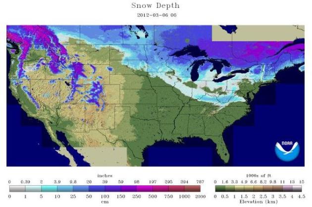
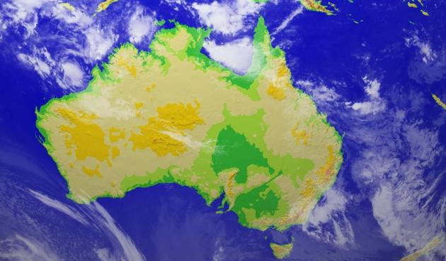
Going Fast. If you like snow you may want to get out there and roll around in it sooner, rather than later. There won't be much left by next weekend, except for northern Minnesota, Wisconsin, the U.P. of Michigan, the snow belts downwind of the Great Lakes, and northern New England. Map above courtesy of
NOAA.
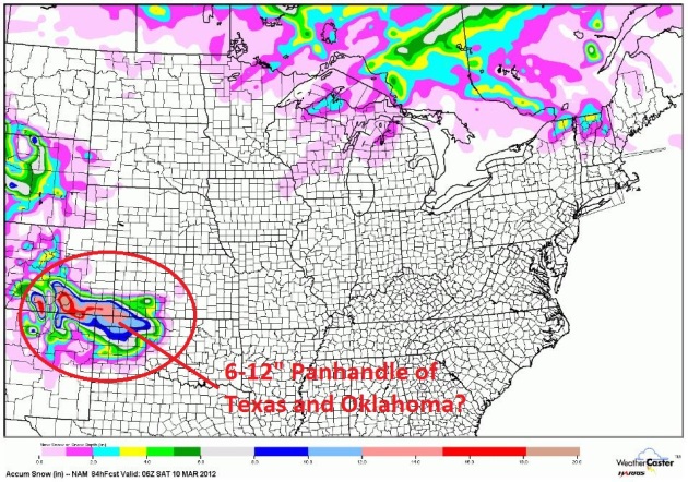
A Parallel Weather Universe? No significant snow close to home anytime soon, at least looking out 2 weeks (a little lake effect snow for the U.P. of Michigan). No, for substantial snow you have to drive to the panhandle of Oklahoma or Texas, where some 6-12" snowfall amounts are possible. 50+ here on Saturday, while north Texas digs out from a freak snowstorm. Go figure.
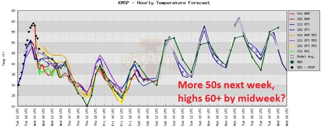
Seasonably Cool Through Friday, Then More April. We cool down today, temperatures still a few degrees above average Thursday annd Friday. I suspect we'll top 50 Saturday and Sunday, maybe climb close to 60 by the middle of next week. The ECMWF shoots the mercury above 70 by Wednesday of next week. That may be a bit extreme, but the ECMWF has been doing a pretty good job this "winter".
Daylight Saving Time This Weekend. Man, that was fast! We "spring forward" one hour late Saturday night (2 am Sunday morning).
NASA has more than you ever wanted to know about DST here: "
Benjamin Franklin is credited with the concept of Daylight Saving Time. The basic idea is to make the best use of daylight hours by shifting the clock forward in the Spring and backward in the Fall. Daylight Saving Time has been in use throughout much of the United States, Canada and Europe since World War I. In 1966, President Lyndon Johnson signed an act into law whereby Daylight Saving Time begins on the last Sunday of April and ends on the last Sunday of October each year. However, any State can opt out of Daylight Saving Time by passing a State law. Hawaii does not observe Daylight Saving Time and neither does Arizona (although the Navajo Nation, in northeastern Arizona, does). For many years, most of Indiana did not observe Daylight Saving Time with the exception of 10 counties. Beginning in 2006, all of Indiana now observes Daylight Saving Time. However, the state remains divided in two time zones. Seventy-four counties (including state capital Indianapolis) are in the Eastern Time Zone. The 18 remaining counties are in the Central Time Zone (see: Indiana Time Zones)."
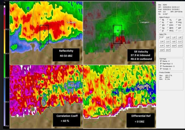
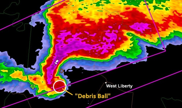
The Advantages Of "Dual-Pol". The National Weather Service is retrofitting all NWS Doppler radars around the USA to be dual-polarization, sending out pulses of energy in the vertical, as well as the horizontal axis. This allows meteorologists to do a better job estimating raindrop/hailstone sizes, and also allows forecasters for the first time to see debris kicked up by tornadoes on the ground. Here is more, from the
Facebook page of the Nashville Office of the NWS: "
Here is an example of a TDS or Tornado Debris Signature indicated by our new Dual-Pol Radar. The four-panel display allows us to see many different radar variables at one time. In the upper left panel we have our traditional reflectivity, upper right is Storm Relative Velocity, lower left is Correlation Coefficient, and lower right is Differential Reflectivity. In order to detect a TDS we look for very low Correlation Coefficient values near the tornadic signature on Storm Relative Velocity, if reflectivity values are above 30 dBZ and Differential Reflectivity is low 0."
Coming Soon To A Weather Service Office Near You. More on the merits of "dual-polarization" Doppler Radar. Here's an excerpt of a story at abcnews4.com in Charleston: "Technology advances quickly. Take for instance, iPads or iPhones. On average the new model comes out every eight months to a year, making older models a bit outdated. Let's just say the same goes for weather forecasting. Twenty years is way past time to update. "The National Weather Service WSR 88-D radar for the Charleston area was commissioned in Grays, S.C., northern Jasper County in 1992," said Steve Taylor, a meteorologist with the Charleston office of the National Weather Service. The current radar output is serviceable and continues to detect rain, but a newer more advanced dual-polarization radar technology is available and will be installed later this year. "The entire United States network of 160 radar sites, including Alaska, Hawaii, Puerto Rico and Guam will be upgraded by early 2013 at a cost of about $50 million," Taylor said." Photo above courtesy of NOAA.
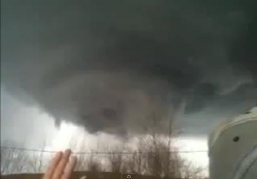
Close Encounter With A Kentucky Tornado. Hey, I'd be praying (out loud) too, if an EF-3 tornado was approaching my home. There's a reason why this
YouTube clip has over 43,000 views. Details: "
Dramatic video as a funnel cloud approaches a woman's home in Ezel, near West Liberty, Kentucky and she "prays" the tornado/funnel cloud away from her home."
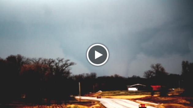
Storm Chasers: "It Was A Very Fast Evolution." The story (and amazing video) from
jconline.com: "
Two Purdue University storm chasers watched Friday's deadly twister form and hit the ground in just four minutes. As Ph.D. students in the Severe Weather Research Group, Mallie Toth and Eric Robinson have chased many violent storms in recent years. But the tornado that tore through southern Indiana will be remembered for its speed and strength. The funnel cloud came right at them while they were parked on Indiana 135 between the towns of Salem and Palmyra in Washington County. "We were directly in the path," Toth said Saturday. "It was a very fast evolution."
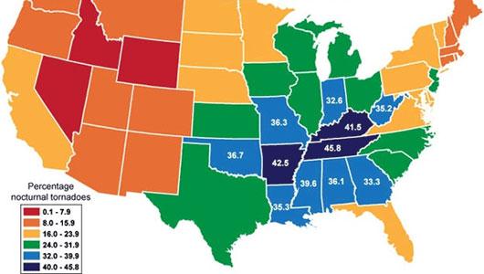
Watch Out For Deadly Nighttime Tornadoes This Winter. Some interesting statistics and trends in this story from MNN,
Mother Nature Network: "
As recent tornado outbreaks around the country have shown, severe weather is getting a jump on the spring season. The main tornado season may still be weeks away, but the twisters of winter pack an extra threat. The odds of a killer tornado are greatest at night, and the shorter daylight hours of winter increase the chance of nighttime tornadoes. Nocturnal tornadoes are more than twice as likely to kill people than daytime tornadoes, researchers have found. So far, the largest tornado outbreak of the year — 45 twisters — came on Jan. 22. Feb. 24 was the second busiest day for severe weather of the year to date."
Photo credit above: "NIGHT SPIRALS: A graph showing the percentages of nocturnal tornadoes by state from 1950 to 2005. (Image: OurAmazingPlanet)."
Early Tornadoes Not Predictors For Future Twisters. The story from CNN and
ozarksfirst.com: "
When a powerful jet stream bringing in cold northern air collided with a large mass of warm, moist air from the south, the conditions were right for the tornadoes that have left at least 45 dead this week. Two powerful storm systems in the Midwest and South spawned the tornadoes that damaged and destroyed homes and businesses from Kansas to Ohio. There is not a defined tornado season like there is for hurricanes, but this year the first major tornadoes came earlier than usual. Last year, the most powerful tornadoes were not seen until April."
Severe Weather Preparedness Week In Illinois. Some good information from
WREX-TV: "
There are many indications that this could be an active - and early - severe weather season in Illinois. Severe weather has already impacted parts of Illinois and neighboring states. 2011 was a devastating year for tornadoes in the United States. There were more than 1700 tornadoes nationwide, including 59 killer tornadoes which claimed 550 lives. It was the deadliest year for tornadoes since 1925.
· Tornadoes are the most destructive storms that occur in Illinois. Being prepared for a tornado can save your life.
· A tornado watch means severe thunderstorms and tornadoes are possible in your area over the next few hours. Be prepared.
· A tornado warning means a tornado has been sighted by a trained storm spotter, or intense rotation that will likely produce a tornado has been detected by Doppler radar. Get to a place of safety immediately."
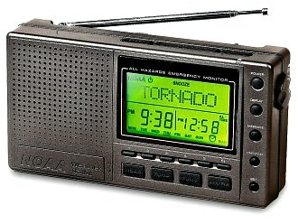
Weather Service Urges Radios For Storm Readiness.
WLS-TV in Chicago has the story: "
Despite the tornado sirens sounding in downstate Harrisburg Wednesday morning, a lot of people stayed asleep and did not hear them. According to advice from the National Weather Service, there is a simple way to make sure when that there is a severe weather alert, you get it. In recent years there have been major improvements in tornado forecasting allowing for earlier warning lead times. They now average 13 minutes, but when it comes to receiving those warnings, many people are still relying on 20th century technology."
Forecasters Will Be Able To Reliably Predict Where A Hurricane Will Be A Week Ahead Of Time. This may be a little optimistic, but there's little doubt that NHC is having very good luck (skill, really) predicting hurricane tracks, with significant improvement in accuracy every year. Predicting intensity of hurricanes is much more difficult.
NJ.com has an interesting story: "
CHARLESTON, S.C. — National Hurricane Center Director Bill Read said Monday that science will improve to the point where forecasters can reliably issue forecasts showing where a hurricane will be a week ahead of time. "We're two to five years from a seven-day forecast," Read told reporters while attending a conference with representatives of other federal agencies to discuss hurricane forecasting and warning. He noted the National Weather Service now issues regular daily weather forecasts a week out — but not yet for hurricanes."
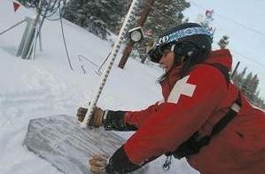
The Inexact Science Of Snow Reporting. Yes, predicting snow, down to the inch for specific locations, is as much a black art as it is a science.
The Aspen Times has an article that caught my eye, capturing some of the nuance (and hair-pulling difficulties) of forecasting snow: "
VAIL, Colo. — When a ski resort that covers 5,289 acres — the largest in the United States — reports the snowfall that has occurred over the last 24 hours, there is and will always be areas of the mountain that don't match up to what's reported. Some areas might have less snow, and other areas might have more. In the case of last week's snow reporting debacle, in which Vail reported 12 inches the morning of Feb. 23 and later retracted that report and changed it to 2 inches, the reading of the mountain's snow measuring stake was simply inaccurate because high winds had blown in too much snow, the resort reported. Getting a snow measurement before 5 a.m., which is when the operator in the Vail Communications Center at the base of the mountain does the reading, can be tricky business. The situation last week was simply an anomaly, though, said Bob Norris, manager of Vail Mountain security. "
Photo credit above: "Vail ski patroller Jennifer Silva clears off the snow stake after confirming the snowfall reading from the stake at 7 a.m. for the past 24 hours Wednesday on Vail Mountain. Dominique Taylor / Vail Daily."
Thousands Flee In Australia Floods.
MSNBC.com has the latest: "
CANBERRA — Floods across eastern Australia forced more than 13,000 people to evacuate their homes on Tuesday after record-high summer rains drenched three states over the past week, swelling rivers and forcing dams to overflow. In the worst-hit state of New South Wales, authorities ordered 8,000 people to leave their homes in the inland city of Wagga Wagga, where flood waters were expected to breach an 11-metre levee and swamp houses and the main business district."
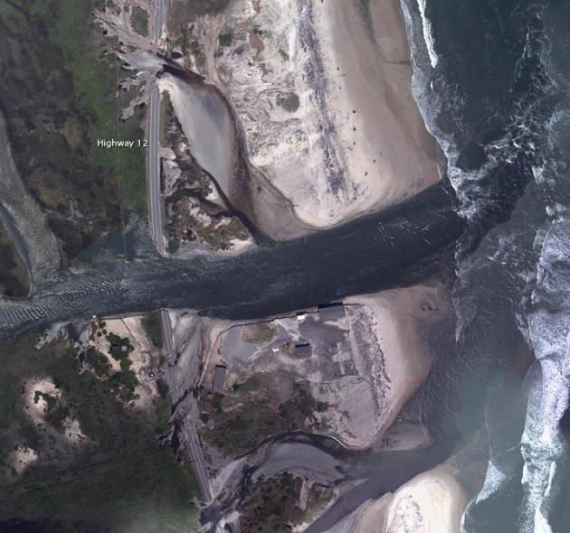
A North Carolina Lifeline Built On Shifting Sands. I've spent some time on the Outer Banks of North Carolina - gorgeous country, but very vulnerable to hurricanes. Those barrier islands and dunes were designed to migrate over time. Paving them over with roads and parking lots hasn't stopped that migration of sand, which becomes all too apparent every hurricane season (or even during winter with strong nor'easters).
The New York Times has the story: "
RODANTHE, N.C. — Last August, when Hurricane Irene sliced across the Outer Banks, it cut Highway 12, Hatteras Island’s lifeline, in two places. Engineers rushed to repair the damage, filling and repaving a washed-out stretch of roadway here and building a bridge over a newly formed inlet a few miles to the north. The road reopened on Oct. 11, to the cheers of anglers, would-be vacationers and the innkeepers, restaurateurs and merchants whose livelihoods had taken a huge blow. But the winds and waves that shape the coast were already gnawing at the new bridge."Photo above courtesy of
NASA's Earth Observatory.
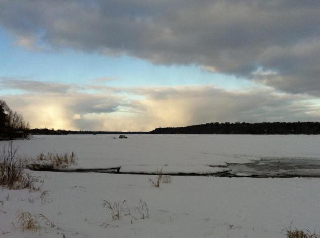
Photo Of The Day. Thanks to Tim Wright from Sauk Rapids for passing this one along - a beautiful example of lake effect snow showers and squalls. He writes: "My son Drew and I were just finishing up a long day of snowmobile riding in the late afternoon (5 pm) in my hometown of Solon Springs, Wisconsin when I took this photo on Sunday March 4. It is looking north on Lake St. Croix (where the St. Croix river begins) toward Lake Superior (appox 25 miles to the north). It was a pretty picture of the sun’s angle striking the side of the clouds that were continuously forming over the western end of Lake Superior that day creating continuous lake effect snow. You can see the moisture from the clouds with the naked eye better than my Iphone photo, but I thought I would share. I love the Star Tribune Blog!!"
Thanks Tim (and Drew). I'm genuinely amazed at the quality of photos you can get from today's smartphones. Keep up the great work with that iPhone! Good to have you as a loyal reader - I take nothing for granted. Thank you.
Paul's Links. Weather-Related Q&A.
1).
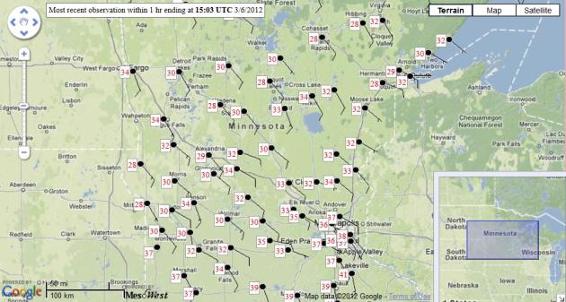
Current Conditions From MesoWest. This is a good site that visualizes current weather, for the metro, Minnesota, or anywhere in the USA. Using a Google Map you can zoom in/out, pan, and call up various meteorological parameters like temps, highs, lows, precip, etc. Definitely worth a look.
2).
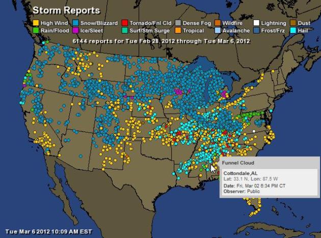
Storm Reports From Ham Weather. Full disclosure: Ham Weather is a subsidiary of Media Logic LLC, but these maps are free to access for general consumers. This map shows NWS storm damage reports for the last 4 hours, 24 hours, or even a week's worth of storm reports (above). You can separate out tornado reports from flooding, high winds, hail, etc - and it's interactive. Hover your cursor over the dot and you pull up more details. I'm biased, but it's pretty cool.
3).
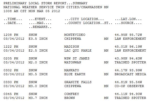
National Weather Service Public Information Statements. This is a handy site to pull up the latest snowfall/rainfall reports for Minnesota and Wisconsin, as well as storm report details.
4).
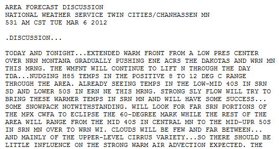
National Weather Service Forecast Discussions. This specific link is more technical, but if you want to know what NWS meteorologists in Chanhassen (and Duluth) are really thinking, and why the NWS forecast is what it is, check this sight for more insight into the how's and why's of the weather floating overhead.
Long Career From Long-Range Forecasts.
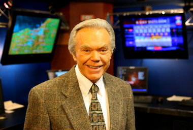
TVNewsCheck.com takes a look at the distinguished TV career of meteorologist Dick Goddard in Cleveland: "
In 1961, a young Dick Goddard, with five years of experience as a meteorologist for the weather bureau at the Akron-Canton Airport and zero experience in television, made his debut on KYW, then the Westinghouse NBC affiliate in Cleveland. To some, the idea of a weather expert seemed a bit much. On Goddard’s debut newscast, the sports anchor wryly alerted viewers: “Dick Goddard, the first meteorologist on Cleveland television, will be here with his first rumor in two minutes.” That debut turned into history. last year Goddard celebrated 50 years on television, most of it at Cleveland’s Local TV LLC Fox affiliate, WJW. The city named a street in his honor. In Cleveland, he’s as synonymous with weather as rock salt." Photo:
cleveland.com.
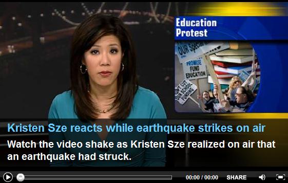
Earthquake Shakes KGO-TV During Morning Newscast.
TVSpy.com has the story (and video): "
Most San Francisco residents were asleep yesterday when a pair of earthquakes struck the Bay Area around 5:30 a.m. But Kristen Sze and Eric Thomas, the co-anchors of the early morning newscast on KGO, were wide awake. “I believe we’re feeling an earthquake right now,” Sze said, interrupting a report on an education rally (video above). “In fact, a pretty big earthquake. The studio is shaking.” “Good jolt, lasted for a few seconds,” Thomas responded. “In fact, it might have felt like what appeared to be two jolts, a smaller one and then a larger one. The lights were shaking pretty good in here.”
As New iPad Debut Nears, Some See Decline Of PC's. An article from
The New York Times (subscription required): "
The chief executive of Apple, Timothy D. Cook, has a prediction: the day will come when tablet devices like the Apple iPad outsell traditional personal computers. His forecast has backing from a growing number of analysts and veteran technology industry executives, who contend that the torrid growth rates of the iPad, combined with tablet competition from the likes of Amazon.com and Microsoft, make a changing of the guard a question of when, not if. " Photo:
ipad3interesting.com.
Ford Teams With Facebook To Create "Social" Car. Hey, I'm all for social media and staying connected, even when I'm on vacation, spending quality time in the bathroom, sleeping, and (of course!) driving. Because when I'm hurtling down I-394 I absolutely want to know what my Facebook friends are thinking/saying.
Gizmag.com has the horrifying details: "
Automakers have begun slowly integrating social networking into vehicles via advanced infotainment systems that provide voice-activated social functions. In a recent collaboration with Facebook called "Hackathon," Ford gave the world a glimpse of what in-car social networking 2.0 might look like. It's scary and intriguing at the same time."
The $500,000 788 BHP Brabus Bullit Stealth Coupe - The Ultimate Sleeper. Politically incorrect? Absolutely.
Gizmag.com has more details: "
It's the ultimate sleeper! Brabus' matte-black stealth coupe has no outward pizzazz whatsoever (at least to the untrained eye), but with a 788 bhp twin-turbo V12 under the hood, it can hit 100 km/h in 3.7 seconds, 200 km/h in 9.8 seconds, 300 km/h (186 mph) in 23.8 seconds on its way to a top speed of more than 370 km/h (230 mph)."
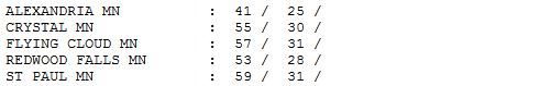
Loss For Words. Any adjective I dig out of my back pocket won't begin to capture just how remarkable yesterday. If you wandered outside Tuesday afternoon you know. You walk out the door, tensing up, bracing for a chill, and....nothing. Like we had all suddenly been transported to late April or early May. Highs ranged from 41 at Alexandria to 48 St. Cloud, a balmy 60 in the Twin Cities.
Paul's Conservation Minnesota Outlook for the Twin Cities and all of Minnesota:
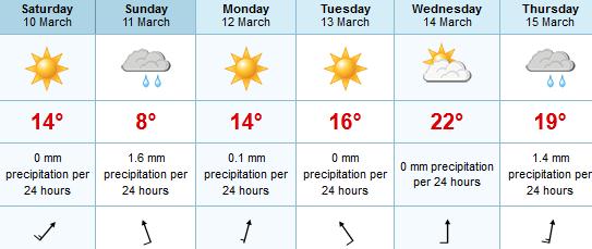
TODAY: More clouds, passing shower or sprinkle. Windy and much cooler. Winds: NW 20. High: 35
WEDNESDAY NIGHT: Partial clearing, chilly. Low: 19
THURSDAY: Partly sunny, less wind. High: 39
FRIDAY: Bright sun, quite pleasant. Low: 22. High: 37
SATURDAY: Spring fever. Hints of April? Low: 28. High: 57
SUNDAY: Less sun, rain possible later, especially WI. Mild. Low: 33. High: 56
MONDAY: Showers probably stay east. Feeling feverish. Low: 35. High: 58
TUESDAY: "Hooky Alert". Too nice to work. Mild sun. Low: 39. High: near 60
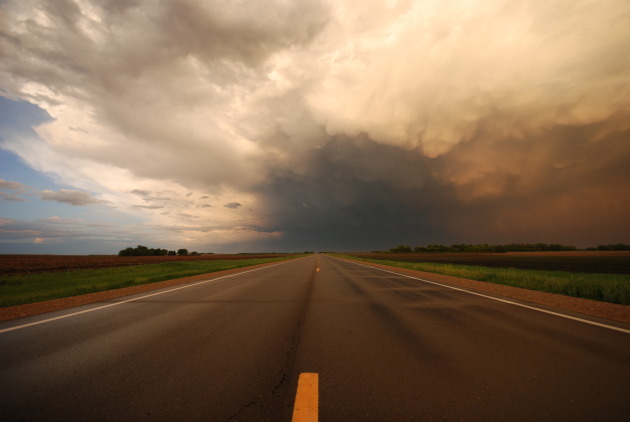
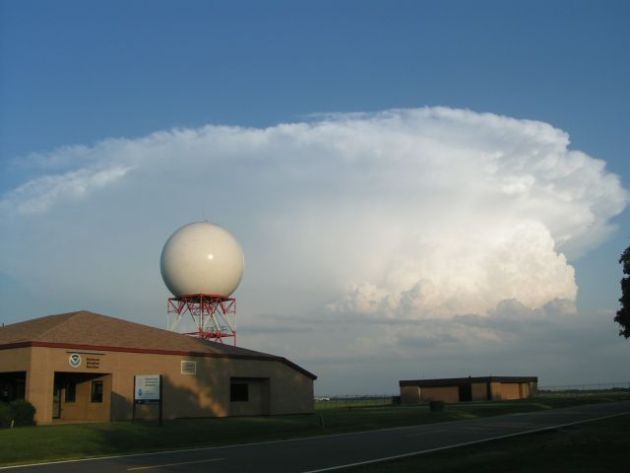
"Supercell". Thanks to the
Wichita office of the National Weather Service for sharing this amazing image.
Doppler Radar Upgrade
160 National Weather Service U.S. Doppler radars are getting an upgrade. Dual-Polarization hardware and software will allow not only push out a horizontal pulse of energy, but a vertical wave. Who cares?
Todd Krause, from the local NWS office, explained why this matters in an e-mail Tuesday. "The purpose of dual pol is to get a better handle on the hydrometeors, which will help with rainfall estimates, hail, and freezing/frozen precipitation." Tornadoes are usually much too small to show up on Doppler - we look for rapidly rotating parent thunderstorms, called "supercells", that often go on to spawn large hail and twisters. With "Dual-Pol", if a tornado is on the ground within 50-75 miles of Chanhassen, radar may be able to see the "debris ball", the actual debris being kicked up by a tornado on the ground. Over time this may result in fewer (rotation-based) false alarms. Here at MSP the upgrade is scheduled for September, Krause told me.
A cooler front kicks up a rain shower or or two today, but 50s return over the weekend. A little rain is possible late Sunday, mainly over Wisconsin. The ECMWF (European) model hints at 60s, even 70F the middle of next week. May-like? Yep.
Climate Stories....
Climate Change May Make Early Tornadoes The Norm: Scientists. The story from
timescolonist.com: "
According to some climate scientists, such earlier-than-normal outbreaks of tornadoes, which typically peak in the spring, will become the norm as the planet warms. "As spring moves up a week or two, tornado season will start in February instead of waiting for April," said climatologist Kevin Trenberth of the National Center for Atmospheric Research. Whether climate change will also affect the frequency or severity of tornadoes, however, remains an open question, and one that has received little study. "There are only a handful of papers, even to this day," said atmospheric scientist Robert Trapp of Purdue University, who led a pioneering 2007 study of tornadoes and climate change." Photo: AP.
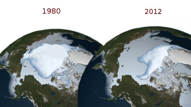
NASA Finds Thickest Part Of Ice Cap Melting Faster. The story from
PR-USA.net: "
A new NASA study revealed that the oldest and thickest Arctic sea ice is disappearing at a faster rate than the younger and thinner ice at the edges of the Arctic Ocean's floating ice cap. The thicker ice, known as multi-year ice, survives through the cyclical summer melt season, when young ice that has formed over winter just as quickly melts again. The rapid disappearance of older ice makes Arctic sea ice even more vulnerable to further decline in the summer, said Joey Comiso, senior scientist at NASA Goddard Space Flight Center, Greenbelt, Md., and author of the study, which was recently published in Journal of Climate. The new research takes a closer look at how multi-year ice, ice that has made it through at least two summers, has diminished with each passing winter over the last three decades. Multi-year ice "extent" – which includes all areas of the Arctic Ocean where multi-year ice covers at least 15 percent of the ocean surface – is diminishing at a rate of -15.1 percent per decade, the study found." Photo credit: NASA.
GM Funding Of Climate Change - Denying Heartland Institute Creates Outrage With Environmentalists. The story from
The Huffington Post: "
The recent disclosure that General Motors' charitable arm has funded a think tank skeptical of climate change fueled an outcry among environmentalists. Now, an environmental group says it has collected 10,000 signatures urging the automaker to stop funding the Chicago-based Heartland Institute. Internal documents leaked in February show that the General Motors Foundation -- which the automaker says is funded separately from business operations -- donated to the institute $15,000 in both 2010 and 2011, with another $15,00 expected in 2012." Photo courtesy of AP.
 Electric Cars And The Liberal War With Science
.
The Washington Post has more: "
President Obama boasted at a United Auto Workers conference last week that General Motors was back in business, producing cutting-edge vehicles like the plug-in electric Chevrolet Volt. He even promised to buy one when his time in office ends “five years from now.” Whoops! Just three days later, GM announced that it would suspend Volt production for five weeks this spring, idling 1,300 workers at a Hamtramck, Mich., factory. Alas, Obama’s endorsements notwithstanding, there’s not much of a market for this little bitty car, at least not at the price of almost $32,000 — after a $7,500 federal tax rebate." Photo credit:
treehugger.com.
Conservative White Men Lead Climate-Change Deniers. The story from the
Orange County Register: "
Conservative white men are almost twice as likely as other U.S. adults to say that man is not the primary cause of global warming, according to an analysis of Gallup polling data by sociologists Riley E. Dunlap and Aaron M. McCright called, "Cool dudes: The denial of climate change among conservative white males in the United States." I came across the 2011 study while researching my story, "Ideology, not facts, often drives political beliefs," It explores how voters from both major parties arrive at their positions not based on science so much as predilections."
Climate Change Is A Geo-Political "Threat Multiplier", UK Climate Envoy Says. The story from
KPCC Radio: "A senior official in the British Royal Navy came to Southern California last week with a message about how climate change can affect political stability. Rear Admiral Neil Morisetti is climate and energy security envoy for the United Kingdom. He said most people think about a warming climate solely as an environmental problem. “
We haven't really in the past thought of it as a potential security issue,” Morisetti said. But he added that he observes that changing. He's traveling with a counterpart from the U.S. Navy to colleges and military bases to make the case that global warming deserves attention as a military and political issue. Climate change, he said, “can act as a threat multiplier in those parts of the world where tree's already stresses — food, water, health, and demographic challenges, often in countries where governments don't have the capacity and resilience to look after their citizens. And it can act as a catalyst for conflict and therefore increase the risk of instability.”
Photo credit above: "
Rear Admiral Neil Morisetti, the UK's special envoy for climate and energy security, with Nancy Sutley, chair of the Council on Environmental Quality. ECSP/Flickr."
Ocean Renewable Power Company To Install Maine Tidal Energy System. Details from
Huffington Post: "
PORTLAND, Maine (AP) — With its federal license in hand, a Maine-based tidal energy company is ready to install its underwater power system for the first time on the floor of the ocean. Ocean Renewable Power Co. aims to begin installation of its first grid-connected power unit in mid-March at a 60-acre site in Cobscook Bay at the nation's easternmost tip. The first unit capable of powering 20 to 25 homes will be hooked up to the grid this summer, and four more units will be installed next year at a total cost of $21 million for the project, said Chris Sauer, president and chief executive officer of the Portland-based company." Photo above:
inhabitat.com.


No comments:
Post a Comment