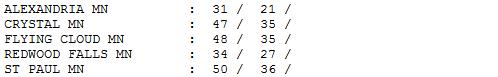
54 F. high yesterday (1:57 am Wednesday morning) in the Twin Cities.
37 F. average high for March 7.
30 F. high temperature a year ago, on March 7, 2011.
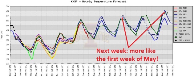
70 F. highs possible between Wednesday and Friday of next week, typical for mid May.
.04" rain fell yesterday at KMSP.
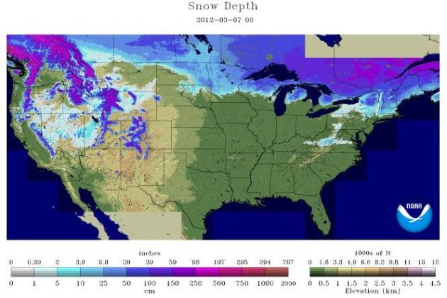
0" snow on the ground.
12" at Duluth,
14" on the ground at International Falls.
Typical...For First Half of May. This is the raw forecast out of the ECMWF model, which shows highs close to 70 from Tuesday through Thursday of next week, maybe low to mid 70s by Friday? Not buying it yet, but considering we've lost (most) of our snowcover, and winds at all levels of the atmosphere will be howling from the south, nothing would shock me at this point. Yes, we seem to have skipped a month, possibly two.
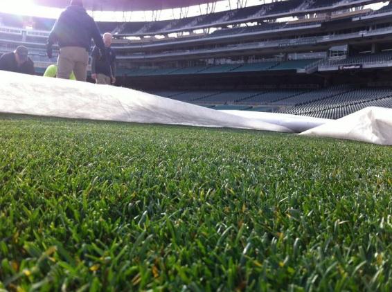
Green Grass At Target Field. O.K. I'm there, sitting in the stands, popcorn, a (large) adult beverage, watching my favorite baseball team. Won't be long now. A sneak peak at Target Field courtesy of the
Minnesota Twins.
Opening Day: April 6 vs. the Baltimore Orioles.
The Home Opener is April 9 vs. the Angels. For more dates and ticketing information for the Minnesota Twins
click here.
"
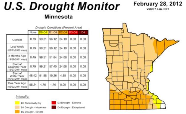
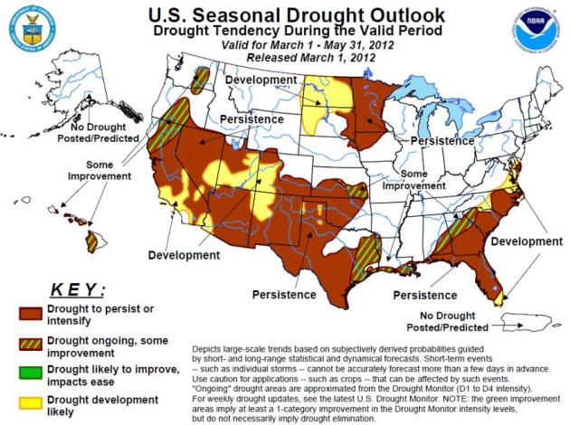
Without ample, widespread precipitation in the late winter and early spring, Minnesota will face a number of drought-related issues at the beginning of the 2012 growing season. The drought situation will become rapidly apparent in the spring in the form of wildfire potential, deficient soil moisture supplies, and low water levels in wetlands, lakes, and rivers." - climatatologist Greg Spoden, of the Minnesota Climatology Working Group. Details below. Latest Drought Monitor
here.

"
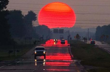
Springtime is the land awakening. The March winds are the morning yawn." - quoted by Lewis Grizzard in "Kathy Sue Loudermild, I Love You." Photo: Yahoo.
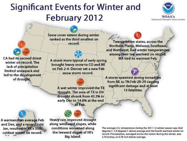
4th warmest meteorological winter on record for Minnesota (and the lower 48 states of the USA). Source: NCDC. Photo credit:
kayakfishingblog.com.
8.64" rain at Lihue, Hawaii Tuesday. This obliterates the old record of 1.14", set in 1974. Source: NOAA. Photo: NASA.
"Unlike snowstorms or hurricanes, which come with plenty of advance warning, tornadoes pose unique challenges for school districts because they can pop up suddenly, leaving little time to scramble to safety." - from a CBS News article below. (AP Photo/Nam Y. Huh)
"A Mackinac Center report says the real cost of the (Chevy) Volt is closer to $300,000. That includes the suggested retail price, the known $7,500 federal subsidy and another $250,000 in taxpayer-funded state and federal incentives for each car". - from an investor.com story (below) focused on the beleagured EV. (AP Photo/David Zalubowski).
"
Scruggs, the lead author, says the public's belief in climate change sagged as the economy dipped and unemployment climbed in the late 2000s, dropping from a belief rate of 60-65 percent in 2008 to about 50 percent in 2010." - from a USA
Today article linking climate change denial with a worsening economy. Details below.
Forget March (and April). Next Week May Feel Like Early May. This is when I start to get nervous; when the weather gets wildly out of whack. Expect 50s this weekend, with a good chance of 60s next week. I have a strong hunch we'll see some low 70s the end of next week. If you don't have spring fever yet, give it about 4 days.
3rd Least Snowcover In Last 46 Years. "The warm and dry conditions during the 2011-2012 winter season limited snowfall for many locations. According to data from the
Rutgers Global Snow Lab,
snow cover extent during winter was approximately 237,000 square miles below the 1981-2010 average — the third smallest winter snow cover footprint in the 46-year satellite record. Snowpack was particularly limited across parts of the West, where parts of California, Nevada, and Arizona had snowpack less than half of average." - source: NOAA's
NCDC. According to
NOAA 24.1% of the lower 48 states were covered with snow as of March 7.
Climate Report For February And Winter. The latest from NOAA's
NCDC: "
Warmer-than-average temperatures dominated the northern and eastern regions of the country in December, January and February, leading to the fourth warmest winter on record for the contiguous United States. The winter season was also drier-than-average for the Lower 48, with dry conditions experienced across the West and the Southeast but wetter-than-average conditions in the Central and Southern Plains and parts of the Ohio Valley. The average contiguous U.S. temperature during the December-February period was 36.8 degrees F, 3.9 degrees F above the 1901-2000 long-term average — the warmest since 2000. The precipitation averaged across the nation was 5.70 inches, 0.78 inch below the long-term average."
Winter Numbers. Nationwide, it was the 4th warmest meteorological winter on record. It was the 4th warmest winter for Minnesota, Michigan and Illionis, the third warmest for Wisconsin. Source: NCDC.
Growing Drought Concerns. Here's an update from Greg Spoden and a HydroClim Minnesota summary, from the
Minnesota Climatology Group:
- Many drought-stricken Minnesota counties received above-normal precipitation in February 2012. Monthly precipitation totals topped the historical average by more than one inch over most of southern Minnesota. However, this welcome precipitation only partially mitigated the very large moisture deficits built up during the late summer and autumn of 2011.
- The U. S. Drought Monitor depicts nearly every Minnesota county as experiencing some level of drought. A large portion of northeast Minnesota, where river and lake levels are very low, is placed in the Severe Drought category. The Drought Monitor also rates much of southern Minnesota in the Severe Drought category. Nearly all other Minnesota locales are determined to be in Moderate Drought.
- Without ample, widespread precipitation in the late winter and early spring, Minnesota will face a number of drought-related issues at the beginning of the 2012 growing season. The drought situation will become rapidly apparent in the spring in the form of wildfire potential, deficient soil moisture supplies, and low water levels in wetlands, lakes, and rivers.
* more on Minnesota's persistent drought from NOAA NCEP
here.
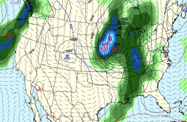
Potential For A Real Storm? The GFS forecast above is valid late in the day on March 21, nearly 2 weeks out, so my confidence level is low. If it verifies we could see heavy rain, ending as a period of snow. Even though next week may see near-record warmth I wouldn't entirely write off the potential for 1 or 2 more significant snowfalls. It would be cruel going from 70-ish to slushy snow, but keep in mind that late March snowfalls usually don't stick around for long.
A Tale Of Two Seasons. The weather may be May-like the end of next week, showers, even a few T-storms possible for St. Patrick's Day. The GFS is hinting at a far more significant (southern) storm tracking just south/east of MSP around March 20-22, probably warm enough for mostly rain, but I wouldn't rule out a changeover to wet snow at the tail-end of the storm. We don't even know if this storm is real (yet), so it's wildly premature to speculate about amounts or timing.
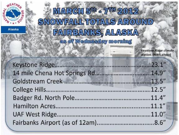
A Town That Had A Real Winter. Here's a post from the
Fairbanks office of the National Weather Service: "
The Fairbanks area has received their largest snowfall of the season. Snow started falling late Monday evening and continued through Wednesday morning. Thanks for the updated snow totals from our spotters and CO-OP observers in the region. Several more inches of snow are possible across the Fairbanks area today before the snow comes to an end this evening."
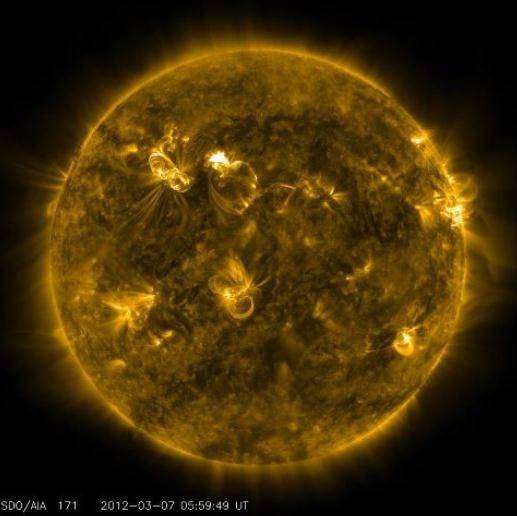
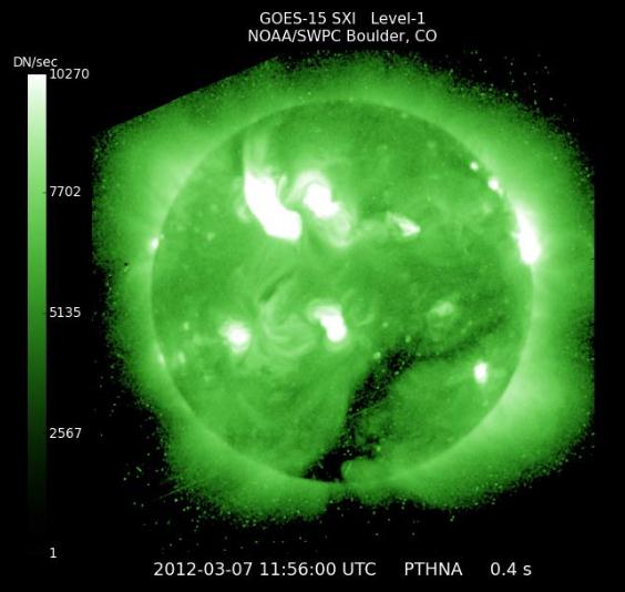
Strong Solar Storm Impacting Earth. From
NOAA. GPS systems may be impacted; a higher probability of seeing the Aurora Borealis; with any luck the power grid won't be affected.
"
A solar flare erupted from the Sun on Tuesday night at 7:04pm EST, creating a Strong (R3 level) Radio Blackout. The initial affects were mainly felt over the Pacific Ocean, during the central U.S. overnight period, which happened to be the sunlit side of the Earth at that time. The primary impact was a temporary degradation of High Frequency (HF) radio communications, which also affected communications with commercial aircraft over the Pacific."
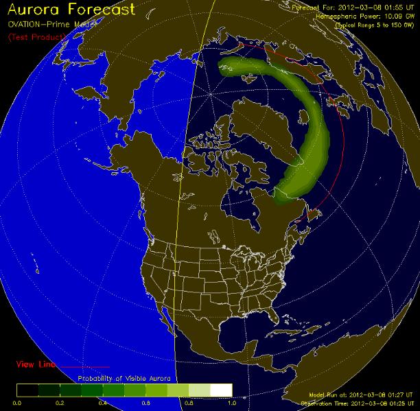
Site Of The Day: Ovation Auroral Forecast. This is the first time I've seen this - "
Ovation" - a test product from NOAA's Space Weather Prediction Testbed, NOAA and Johns Hopkins. More details: "
OVATION: An empirical model of the intensity of the aurora. The model uses solar wind conditions and the IMF at the L1 point as inputs.
The Display: Shows the intensity and location of the aurora as expected for the time shown at the bottom of the map. This forecast is based on current solar wind conditions and the average time for the solar wind to propagate from the ACE satellite at L1 to Earth. The model produces an estimate of the intensity of the aurora. In this product a linear relationship between intensity and viewing probability is assumed. This relationship was validated by comparison with data from the UVI instrument on the NASA POLAR Satellite ."
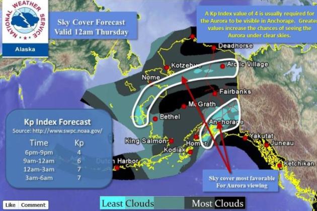
Predicting The Northern Lights. In Alaska, where aurora is fairly common, NOAA routinely predicts the odds of seeing the magical Northern Lights. You can check out the latest forecast on the Alaska NWS
Facebook site.
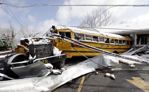
Schools Face Tough Calls With Tornado Oubreaks. It's a real problem: if a tornado watch is in effect do you send kids home early? Are they ultimately safer at school or at home? Getting caught by a tornado on the way home would be catastrophic, so school administrators are faced with a real no-win situation during a scenario like last Friday, when tornadoes swept across the Ohio Valley at roughly the same time many schools were letting out.
CBS News tackles the problem: "
HENRYVILLE, Ind. — Friday's tornado came at the worst possible time for the hundreds of students loaded on school buses, ready to head home in Henryville, Ind. There was no time to follow the preferred safety plan and herd students off the bus and inside the school. Instead, an assistant principal signaled drivers to go, setting off a desperate race to beat the tornado that was just minutes from slamming into the town and destroying a large part of the school. Unlike snowstorms or hurricanes, which come with plenty of advance warning, tornadoes pose unique challenges for school districts because they can pop up suddenly, leaving little time to scramble to safety."
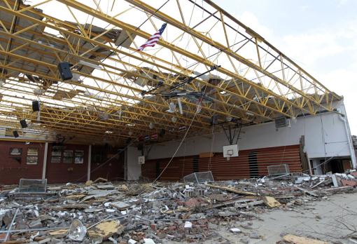
Photo credit above: "
This March 3, 2012 file photo shows an American flag flying over the damaged gym at Henryville High School in Henryville, Ind.. Unlike snowstorms or hurricanes, which come with ample warning, the sudden nature of tornadoes presents unique challenges for school officials deciding whether to hold students in place or send them home. The choice, they say, boils down to evacuating well ahead of a storm or sheltering students inside until the storm passes. Neither is guaranteed to save lives. (AP Photo/Michael Conroy)."
After The Storms Have Passed. Here's a poignant essay at
The Washington Post: "
LOUISVILLE, Ky. — As I boarded a flight in New York, television monitors in the terminal told horrific stories of tornadoes devastating towns and cities across the Ohio River Valley, where I was heading. I recognized some places being hit, including my birthplace in southwestern Indiana. Others, like Henryville, Ind., just north of Louisville, were unfamiliar to me. Still, I recognized the stories they told, of school buses filled with children racing to stay ahead of the storm; of houses flattened and lifetime treasures destroyed; of businesses closing early and hoping to find walls standing the next day. More than 30 people died, including a baby who was carried 10 miles by the wind and dropped into a cornfield."
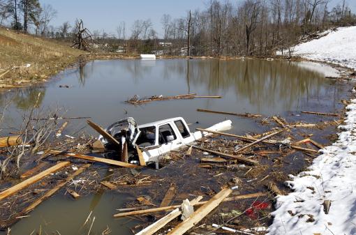
Photo credit above: "
Mike Justice's pickup truck remained in a pond near his girlfriend's house in Woodbend, Kentucky, Tuesday, March 06, 2012. He was with his girlfriend, Melissa Rose, when the tornado struck. Rose's house was completely destroyed leaving only the basement foundation. They survived. Morgan County suffered 5 fatalities and significant damage as numerous tornados moved across Kentucky last Friday. (Charles Bertram/Lexington Herald-Leader/MCT)."
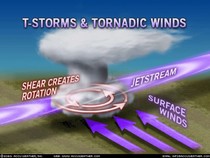
Tornado Season: How Do Meteorologists Predict Twisters? Here's a good overview of the science of tornado prediction from
Time Magazine: "
March isn’t typically the busiest time of year for tornadoes. But the residents of Henryville, Ind., can take no solace in that fact, after a powerful EF-4 category storm with winds of 175 mph ripped through town last week. And, unfortunately, neither can the rest of the Midwest, as towns await the brunt of cyclone season. Deadly tornadoes continue as a frightening reality in the U.S, especially throughout an area dubbed Tornado Alley (the majority of Texas, Oklahoma, Kansas, Nebraska and portions of other states, including southern Indiana). The threat of the wind-whipping funnels is most acute in May and June. Harold Brooks, a meteorologist with the National Oceanic Atmospheric Association’s National Severe Storms Lab, says tornadoes occur when certain weather elements come together. The mix happens most often in May and June, with April a close third, and a few other points throughout the year during shifting seasons, such as March and September."
NASA Studies March 3 Severe Weather Outbreak With Infrared And Microwave Vision. Details from
NASA: "
A NASA satellite used infrared and microwave "vision" to analyze the storm system that created the March 3 severe weather outbreak in the U.S. On March 3, 2012, the Atmospheric Infrared Sounder (AIRS) instrument flies aboard NASA's Aqua satellite captured infrared and microwave data of the front that generated the severe weather during the early morning and early afternoon hours. On the Aqua satellite's first overpass on March 3, infrared data from AIRS showed the strong low pressure area centered on the Great Lake that powered a cold front into the U.S. South and ahead of the front lay an incursion of unusually warm moist air. Where the two met, a line of severe thunderstorms developed which spawned the killer tornadoes and damaging straight line wind storms."
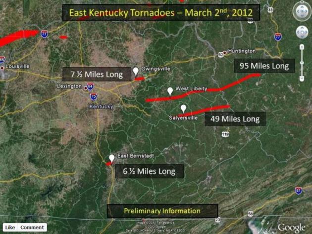
Kentucky Tornado Tracks. More details from the
Jackson, Kentucky office of the National Weather Service:
"Ground surveys for the March 2nd tornado outbreak have been completed by NWS Jackson, KY. The surveys have revealed four separate tornadoes affecting parts of nine different counties and causing widespread destruction to the towns of West Liberty and Salyersville. The first tornado in recorded history affected Martin County and this was the first occurrence of an EF2 or greater tornado on record in Menifee, Magoffin, Johnson and Martin Counties."
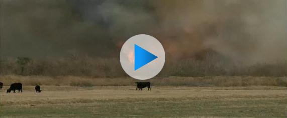
Firefighters Fight Three Brushfires Across Arizona. A lack of significant rain (or snow) has created tinder-dry conditions across much of America. Odds are, unless the pattern reverses itself rapidly, it's going to be a near-record spring for brushfires.
KVOA-TV has more: "
TUBAC, Ariz.- Arizona is under fire again. Gusty winds this week have made conditions perfect for a fire to spread and firefighters worked to put out three across the state Tuesday. The fire closest to Tucson started Tuesday afternoon near Tubac. "All of a sudden we walked outside and the air was full of smoke, Resident Mary Ball says. Ball panicked when she saw the flames, which firefighters believe started in someone's backyard. "We were a little petrified that the winds would shift the flames and we would lose our house, which would be just terrible," Ball says."
200-Acre Clay County, Florida Wildfire Burns Home, Causes Evacuations.
Jacksonville.com has more details: "
A Clay County fire of about 200 acres destroyed one home, damaged another structure and forced some evacuations Tuesday afternoon. What’s being called the “Caribbean Circle Fire” started out as a backyard burn that got out of control about 2:30 p.m, said Clay County Fire Rescue. Two vehicles also were damaged. No one was injured. At 8:45 p.m., the fire was 50 percent contained, according to Clay County Fire Rescue. Heavy smoke may limit visibility in the morning hours, and drivers should be cautious. Residents with respiratory conditions should remain indoors, and keep windows and doors closed."
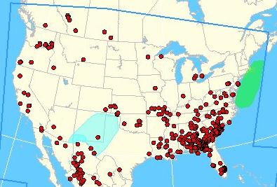
Current Brushfires Around The USA. Using this
NOAA tool you can track real-time brushfires and wildfires around the nation.
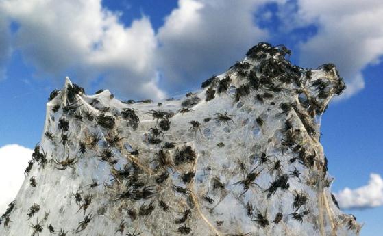
Spider Webs Encase Flooded Australia.
Yahoo News has the nasty details. Can you imagine anything worse? "
Spiders are seen in their webs spun round dry sticks on a bush next to flood waters in Wagga Wagga March 6, 2012. Floods across eastern Australia forced more than 13,000 people to evacuate their homes on Tuesday after record-high summer rains drenched three states over the past week, swelling rivers and forcing dams to overflow. Photo: REUTERS/Daniel Munoz."
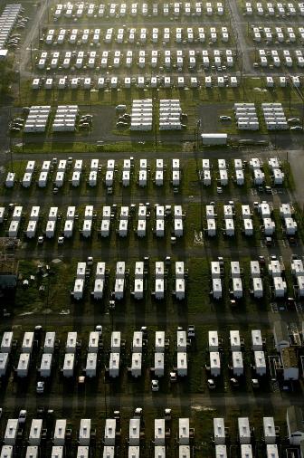
New Orleans Group Promotes Hurricane Awareness. Details from
The New York Times: "
NEW ORLEANS — For most city officials here, making plans to evacuate tens of thousands of residents from the wrath of a hurricane brings to mind a tangle of logistics: bus routes, out-of-state shelters, fresh water supplies, public safety. But for one young transplant named Robert X. Fogarty, evacuation means 12-foot-tall sculptures placed strategically around town...Hurricane awareness has not been a hard sell to people still reeling from Hurricane Katrina. But as memories of the floods recede, Mr. Fogarty and city officials are looking for ways to keep the potential of mandatory evacuation present in the popular consciousness. “That’s our biggest challenge as a city moving forward,” Mr. Fogarty said. “It’s the natural sequence of events of, ‘Well, nothing happened last year...’ ”
Photo credit above: "
This Aug. 28, 2006 file photo shows FEMA trailers used for housing for University of New Orleans students and faculty in New Orleans. The last of the FEMA trailers has been removed from New Orleans more than six years after floodwalls and levees broke during Hurricane Katrina and caused the city to flood. On Wednesday, Feb. 15, 2012 the Federal Emergency Management Agency said the last trailer was removed Sunday. (AP Photo/Alex Brandon, file)."
Aurora Borealis Alert. There have been significant coronal mass ejections (solar flares) in recent days - with vivid displays of the Northern Lights visible as close as the Lake Superior shoreline. Details from NOAA's
Space Weather Prediction Center: "
The NWS Space Weather Prediction Center is monitoring several ongoing space weather events that could have impacts here on Earth. In addition to a recent coronal mass ejection that erupted yesterday evening and is expected to cause geomagnetic storming, a solar radiation storm is in progress. Levels are currently at S2 (Moderate), but are still on the rise at this time."
Paul's Links. Favorite weather-related links:
1).
NexSat Day/Night Satellite Image. Here is a terrific URL, courtesy of the Naval Research Lab in Monterey. Different size images, loop IR clouds, zoom into specific regions. Worth a look.
2).
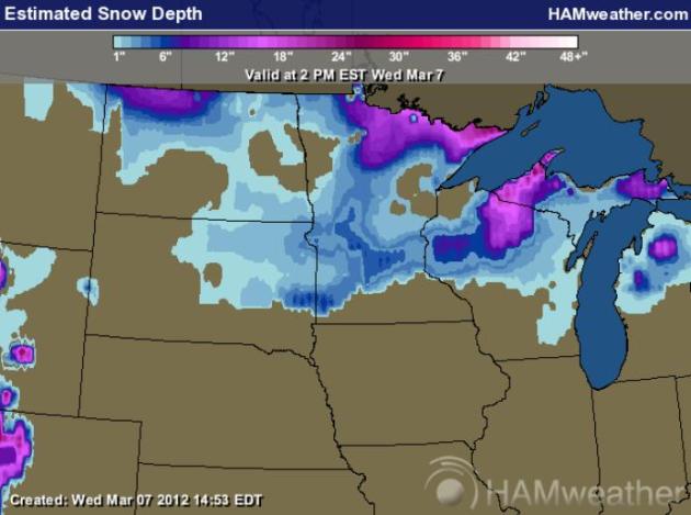
Current Conditions. Call up current conditions, for the Upper Midwest, or any region or state in the USA. Track temperatures, winds, humidity, snowcover (above) and watch the weather morph from hour to hour. Maps courtesy of Ham Weather.
3).
Simuawips. Every local National Weather Service Office has a remarkable tool called AWIPS, which allows meteorologists to see multiple fields up on the screen at the same time, overlaying different parameters, animating them over time. It's sophisticated, but (sadly) not available to the general public. This is as close as I've come to finding an AWIPS-like simulator, a program called Simuawips. You have to set up an account, but it's free. It's powerful, flexible, and has a lot of great mapping capabilities. If you're a true weather nerd (uh...enthusiast sounds better) this is one you should definitely check out.
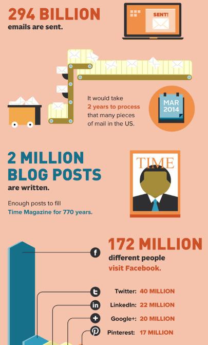
Everything That Happens In One Day On The Internet. I found this fascinating infographic at
Business Insider. A few conversation starters here: "
Our daily life increasingly revolves around blog posts, emails, and status updates. The folks at mbaonline provide a snapshot of what happens in one day on the Internet."
iPad Envy.
Gizmodo.com has more details on the iPad you'll be making (feeble) excuses to stand in line for: "
Apple unveiled the next-generation iPad tablet today, with a super-sharp display (2048 x 1536 pixels, which is 1 million more pixels than HDTV) and quad-core graphics—four times the performance of the iPad 2. In addition to the high-res screen, the new tablet also features:
- A dual-core CPU (the processor is Apple's new A5X chipset, which Apple says is twice as powerful as the A5 found in the iPad 2 and four times more powerful than Nvidia's Tegra 3, according to Gizmodo)
- A rear iSight camera with 5MP sensor and advanced optics, including IR filter, autofocus, face detection, and white balance
- HD video recording (1080p resolution)
- Voice dictation (there's a new key on the keyboard for speaking into the iPad)"
* image above (of the real thing) courtesy of
Apple.
** Gizmodo has a live-stream recap of everything-iPad
here.
Five Leadership Lessons From James T. Kirk. Here's a good story from
Forbes.com: "
Kirk’s success was no fluke, either. His style of command demonstrates a keen understanding of leadership and how to maintain a team that succeeds time and time again, regardless of the dangers faced. Here are five of the key leadership lessons that you can take away from Captain Kirk as you pilot your own organization into unknown futures."
1. Never Stop Learning
“You know the greatest danger facing us is ourselves, an irrational fear of the unknown. But there’s no such thing as the unknown– only things temporarily hidden, temporarily not understood.” (Photo courtesy of Wikipedia).
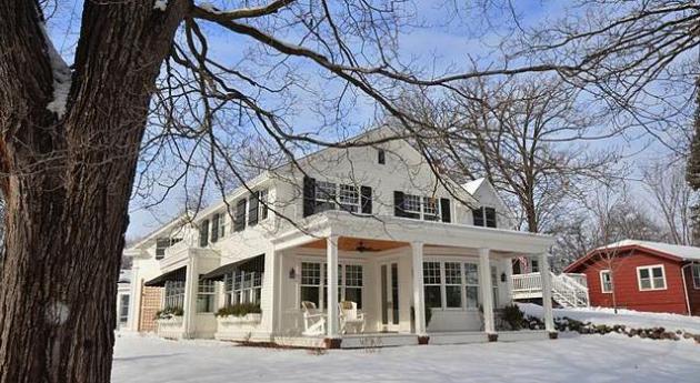
My House On Parade of Homes And A New Way of Thinking. This (very green, very efficient, very cost-effective) house belongs to Don Shelby, who wrote an article about the experience at
minnpost.com: "
Guy walks into my house and says, “So, this is where Paul Magers lives.” That’s how my first experience with the Parade of Homes started. I’ve told you about the energy-efficient home my wife, Barbara, and I built, and now it is a featured house on the spring tour sponsored by the Builders Association of the Twin Cities (BATC). So before we get to call it our own, the crowds move in and put on little paper shoes that make them look like operating room nurses in street clothes. This house is one of the “pay” houses on the tour. It costs the interested five bucks to come through the door. I intend to head to Vegas after the Parade is over."
Photo credit above: "
The house will be certified LEED Platinum, Minnesota GreenStar Gold and BATC Greenpath Master level.Joe Paetzel, The Landschute Group."
An "Ultra-Premium" Bentley SUV? Talk about the definition of wretched excess.
Gizmag.com has more details: "
Whispers about a Bentley SUV - some of them coming directly from Bentley chief Wolfgang Duerheimer - have been floating around for ages. At this week's Geneva Motor Show, Bentley finally puts a face to the rumors. Its EXP 9 F may or may not lead to an eventual production SUV, but it gives the world a look at what a utilitarian Bentley could look like."
Would You Like A Little Sugar With Your Sugar? That's associate producer Alex Buck, drinking Pepsi through a Swizzler (?) I can say that I knew Alex back when he still had teeth. Ah, to be young and reckless again...
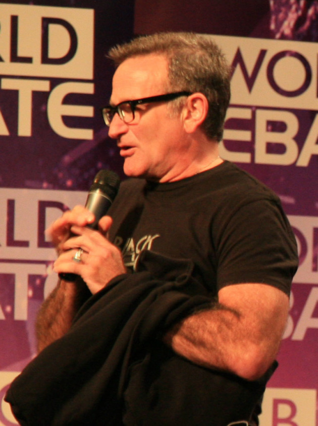
"
Spring is nature's way of saying, "Let's party!" - Robin Williams. Photo:
Wikipedia.
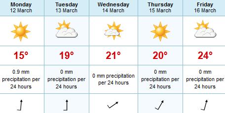
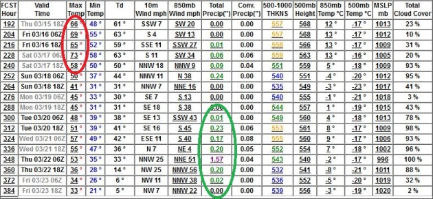
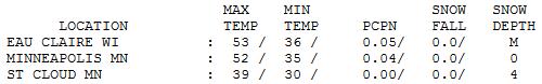
Fleeting Rerun of March. The highs listed above are a bit misleading; we got off to a mild 50-degree plus start, but temperatures quickly tumbled into the 30s behind a vigorous cold front. Only 4" of snow left on the ground at St. Cloud.
Paul's Conservation Minnesota Outlook for the Twin Cities and all of Minnesota:
TODAY: Chilly. Morning sun giving way to increasing clouds. PM flakes up north. Gusty. Winds: NW 15-25. High: 37
THURSDAY NIGHT: Evening flurries, then gradual clearing late, quite chilly. Low: 16
FRIDAY: Blue sky, less wind - a nicer day. High: 39
SATURDAY: Plenty of sun, springy rerun. Winds: SW 15. Low: 31. High: 55
SUNDAY: Clouds increase, rain late in the day (best chance east of the MSP metro). Low: 33. High: 53
MONDAY: Mild sun, typical for late April. Low: 38. High: near 60 (!)
TUESDAY: Lukewarm sun. Is this still March? Low: 40. High: 65
WEDNESDAY: Mild sun, near-record warmth. ECMWF hints at 70. Amazing. Low: 41. High: near 70
* highs may reach 65-72 the latter half of next week, with a growing chance of showers, even a few T-storms, just in time for St. Patrick's Day.
Winter Is Over
"Mom, Uncle Paul is standing too close to the Doppler again!" Yep. Good thing I already had two boys (with some help from my dear, patient wife of 28 years). Yep, I'm off my meds. Let me be clear: we'll see more slush; a few more jacket-worthy cold fronts. But sustained days of bitter cold, close encounters with Snowpocalypse Scenarios? Probably in our rear-view mirror. I'm a little worried about a possible rain-snow event around March 21, but even if we do see snow at the tail-end of that storm it would probably melt within 24-36 hours. You get my drift. The worst ... of what was the easiest winter in 81 years ... is behind us now.
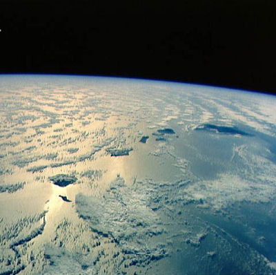
Welcome to a fast-forward spring, a trend in recent years. NASA confirms spring comes 2 weeks earlier than it did a generation ago. We're seeing April weather in March, and after a brief cool-down into Friday - a weather pattern more typical of the first half of MAY is shaping up for next week. Incredible.
NOAA says the lower 48 states just enjoyed/endured the 4th warmest meteorological winter on record. 4th warmest for Minnesota; the 3rd warmest for Wisconsin. According to the Rutgers Snow Lab winter snowcover was the 3rd smallest in 46 years of satellite observations.
Expect flurries later today, more sun on Friday. 50s this weekend give way to 60s next week. I wouldn't be shocked to see 70 (with scattered T-storms?) the latter half of next week. Someday we'll be telling our grandkids about this "winter".
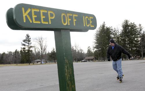
Photo credit above: "Alan Aures skates on his roller blades in a parking lot next to a public ice skating rink covered in thin ice during the mild winter weather in Lancaster, N.Y., Tuesday, March 6, 2012. (AP Photo/David Duprey)."
"
Man must feel the earth to know himself and recognize his values...God made life simple. It is man who complicates it." - Charles Lindbergh, 1972. Photo:
charleslindbergh.com.
Climate Stories....
 James Hansen TED Talk. "Why I Must Speak Out About Climate Change." Huffington Post
 has the story (and video). Definitely worth a few minutes of your time: "
Climate scientist Dr. James Hansen, began a recent TED talk with two important questions. He asks, "What do I know that would cause me -- a reticent, midwestern scientist -- to get myself arrested in front of the White House protesting? And what would you do if you knew what I know?" Hansen explains that his work as a climate scientist dates back to 1981 and a paper he co-authored on global warming. He and his colleagues found that "observed warming of 0.4 C in the prior century was consistent with the greenhouse effect of increasing CO2." He says that they also found, "that Earth would likely warm in the 1980s, and warming would exceed the noise level of random weather by the end of the century."
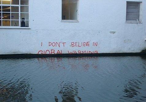
 Global Warming Skepticism Rose As The Economy Tanked.
 The story from
USA Today: "
Americans' skepticism about global warming has increased over the past few years, and a recent study says that the dismal economy is the prime reason. "We suggest that the decline in belief about climate change is most likely driven by the economic insecurity caused by the Great Recession," political scientists Lyle Scruggs and Salil Benegal of the University of Connecticut write in the study. The economy is even more of a factor than partisan politics, supposed biased media coverage, or changeable weather, they say." Photo above: Matt McKean, AP.
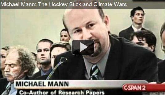
Michael Mann, The Hockey Stick, And Climate Wars. The accompanying video is worth a look - Mann has been through hell and back, for doing his job, and finding compelling scientific evidence of a sudden uptick in temperature, using proxy data as well as data from the thermometer record. And for that he's been persecuted, pilloried in the denial-sphere, subjected to political inquisitions and death threats aimed at him and his family. Because some (professional, well-paid) deniers will stop at nothing to prevent the truth from getting traction. The
Yale Forum on Climate Change And The Media has more: "
A Peter Sinclair original video focuses on climate scientist Michael Mann … on and his first-hand view of his hockey stick and ‘climate wars’ experiences. Years of fierce attacks on climate scientist Michael Mann of Penn State University –- and, more to the point, of the iconic “hockey stick” research –- have made him one of the most well-known and widely discussed scientists in America. Independent videographer Peter Sinclair recently conducted a Skype interview with Mann about the time his Hockey Stick and The Climate Wars book was hitting book stores (see related post). Sinclair’s 10-minute Yale Forum video, with his usual inclusion of poignant visuals and commentary, is designed to help both veteran and “newbie” climate science watchers better identify some of the key players in the hockey stick debate so they can better understand the narrative and the gamesmanship of what Mann’s book describes as the hockey stick “climate wars.”
Climate Change Denial Isn't About Science, Or Even Skepticism.
Canoe.com has more details: "
Lets’ suppose the world’s legitimate scientific institutions and academies, climate scientists, and most of the world’s governments are wrong. Maybe, as some people have argued, they’re involved in a massive conspiracy to impose a socialist world order. Maybe the money’s just too damn good. It doesn’t matter. Let’s just imagine they’re wrong, and that the polar ice caps aren’t melting and the climate isn’t changing. Or, if you prefer, that it’s happening, but that it’s a natural occurrence – nothing to do with seven billion people spewing carbon dioxide and other pollutants into the atmosphere."
Meet Jonathan Foley: "Climate Pragmatist". Dr. Foley at the University of Minnesota is one of the smartest people I know, and I agree with many of his thoughts regarding climate change.
The New York Times (subscription required) takes a look at his approach and world-view: "
Late in 2010, Jonathan Foley, who directs the Institute of the Environment at the University of Minnesota, wrote “Becoming a Climate Pragmatist,” an essay published online then and the following spring in the institute’s magazine, Momentum. You can get a feel for his work and views in the video above in which he explains 2009 research on “planetary boundaries.” I also encourage you to read his 2011 paper, “Solutions for a Cultivated Planet.” I’ve mentioned his essay a couple of times but am overdue to draw direct attention to it, in part because as others have adopted or bashed the term “climate pragmatism,” Foley’s own views have largely been missed." Photo courtesy of the University of Minnesota.
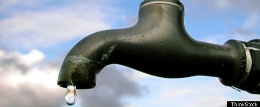
Climate Change Will Stress Water Supplies. The story from
waterworld.com: "
U.S. scientists say climate change may bring unsustainable demands on the world's groundwater supply for agriculture, industry and drinking water. As precipitation becomes less frequent due to climate change, lake and reservoir levels will drop and people will increasingly turn to groundwater for the water needs, researchers said. Groundwater supplies nearly half of all drinking water worldwide, they said, but recharges at a much slower rate than above-ground water sources and in many cases is non-renewable. "It is clear that groundwater will play a critical role in society's adaption to climate change," said San Francisco State University geoscience Professor Jason Gurdak, who co-led a U.N.-sponsored group of scientists now urging policymakers to increase regulations and conservation measures on nonrenewable groundwater. Gurdak said he is recommending closely monitoring or limiting groundwater pumping as well as seeking cooperation from communities to consume less water, something he said his own state has been doing."
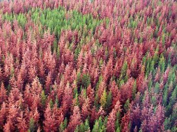
Climate Change Ravaging Forest Service Budget For Wildfire Mitigation, Officials Say.
Realvail.com has the story: "
The warming climate is breeding more beetle-ravaged forest and prolonged fire seasons, U.S. Forest Service Chief Tom Tidwell testified before a Senate committee on Tuesday, as he fielded questions about the White House's proposed agency budget for fiscal year 2013. "We've been doing research on the effects of a changing climate to the vegetation on our nation's forests for over two decades," he told the Senate Committee on Energy & Natural Resources in Washington, D.C. "When it comes to fire, we're definitely seeing much longer fire seasons in many parts of the country, another 60 or 70 days longer than what we used to experience." The Forest Service is not only dealing with an uptick in the number of wildfires, wind storms, droughts and other extreme weather as a result of climate change. "We're also seeing much more severe fire behavior than we've ever experienced in the past," Tidwell noted."
Warming Of 2 Degrees (C) Inevitable Over Canada.
Simon Fraser University (SFU) has the story: "
Halting all emissions of greenhouse gases and aerosols from the Earth’s atmosphere will not immediately stop global warming, says SFU researcher Kirsten Zickfeld, co-author of the first study to reveal this finding. As a result of past emissions, she says the world’s temperature would continue to rise by about a quarter of a degree for 10 years after achieving zero emissions. Considering that the Earth has already warmed by about one degree since the beginning of the industrial era, this adds up to about 1.3 degrees of global warming. In Canada, however, she predicts a warming of as much as two degrees Celsius, since global warming is amplified at high latitudes." Photo: Kirsten Zickfeld.
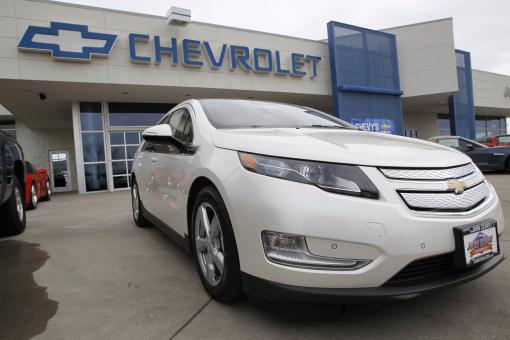
Too Many Volts, Not Enough Buyers, Especially At That Price. A subsidy of $250,000 for every Volt? I did a double-take when I saw that number.
Investors.com has the story: "
Government Failure: Chevrolet is shutting down production of the Volt, its electric car. Not even generous federal subsidies are enough to keep this trendy environmentalist flop on the road. General Motors announced late last week that it will discontinue making its plug-in hybrid between March 19 until April 23 "to keep proper inventory levels." In other words, it can't sell enough of the darned things to justify continued production. Through the end of February, Chevrolet had sold a mere 1,626 Volts though it had planned to build 60,000 of them this year and sell 45,000 in the U.S. market."
Photo credit above: "
In this Sunday, Feb. 19, 2012 photo, a 2012 Volt priced at more than $45,000 is displayed for sale outside at a Chevrolet dealership in the south Denver suburb of Englewood, Colo. General Motors is suspending production of its Chevrolet Volt electric car for five weeks in hopes of reducing inventory to meet lower-than-expected demand. A GM spokesman said Friday, March 2, 2012 that the company will shut down production of the Volt from March 19 until April 23. (AP Photo/David Zalubowski)."


Hello,
ReplyDeleteVery good blog post I love your site keep up the great posts.
Wind Data Logger