37 F. high temperature on Thursday in the Twin Cities.
37 F.average high for March 8.
39 F. high temperature a year ago; March 8, 2011.
2/10ths of an inch of snow fell yesterday at KMSP.
.01" precipitation yesterday.
2.23" actual precipitation since January 1 in the Twin Cities.
2.08" normal precipitation since January 1. Source: NOAA.
 Minnesota Auto Show
 at the Minneapolis Convention Center - going on through March 18.
 Spring Parade of Homes
 continues through April 1. 306 new homes to tour, including Don Shelby's new pad.
 Music To Your Ears
. If you're a fan of spring you'll want to stick around for a sneak peak at next week's forecast. If you like new (local) music with an attitude, scroll down to hear more about "
The Lost Wheels" and where you can check them out.
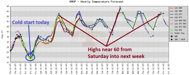
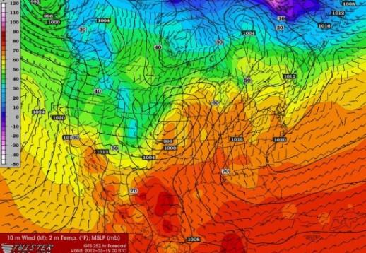
In Search Of March (and the first half of April). Now the GFS is finally coming more into line with the European, ECMWF model, which was hinting at 60s and even 70 a few days ago. After a seasonably cold start this morning, temperatures soar some 20-30 degrees above average from the weekend into next week.
64 F. at Worcester, Massachusetts on Thursday, tying the record last set in 1987.
800 high temperature records, 1,200 records for warmest low temperatures in February across lower 48 states.
200 record cold temperatures in February. Source: Climate Central.
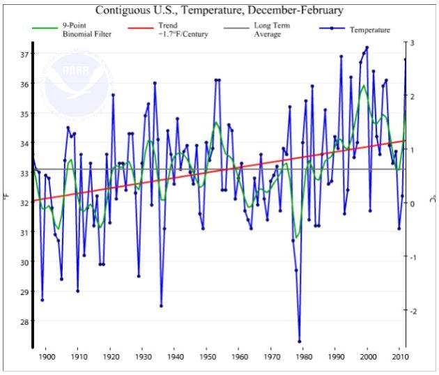
+3.9 F. The Winter of 2011-2012 was nearly 4 degrees warmer than the 1901-2000 average across the lower 48 states. Source: NOAA,
Climate Central.
4th warmest winter on record, warmest since 2000.
1992, 1999, 2000, 2012: warmest winters on record for the USA. Source: NOAA.
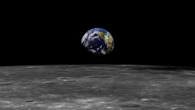
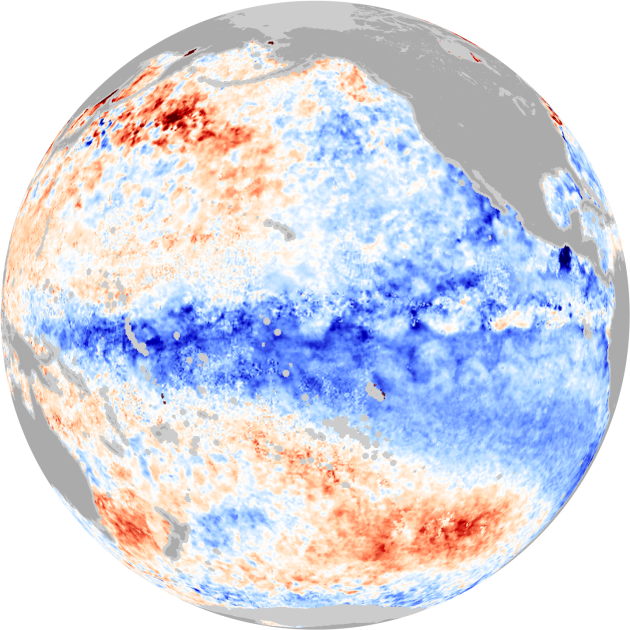 La Nina
 cooling phase of Pacific Ocean water expected to gradually weaken into late spring. More details from
NOAA. Image above courtesy of
NASA's Earth Observatory.
The Winter That Wasn't Checks In At 4th Warmest. Andrew Freedman from
Climate Central has a good overview of our (easy) winter: "
The stats are in on the winter that wasn’t, and the December through February period stacks up as the fourth-warmest winter on record for the Lower 48 states, according to newly released numbers from the National Oceanic and Atmospheric Administration (NOAA). The average temperature for the Lower 48 states during the December through February period, the time span defined as meteorological winter, was 3.9 degrees Fahrenheit above the 1901-2000 long-term average, making it the warmest winter since 2000. The other winters that were warmer than this one occurred in 1992 and 1999."
"
The U.S. Climate Extremes Index, which measures the highest 10 percent and lowest 10 percent in terms of precipitation, temperature, drought and tropical cyclones, finished the season at its ninth-highest value. This means that much of the country — about one-third, to be exact — experienced climate extremes defined by the index, with much of it driven by record warm temperatures." -
Climate Central article. More on the CEI, the Climate Extremes Index, from NOAA
here.
"
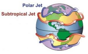
A new study provides evidence that climate change may be affecting the northern hemisphere jet stream. As a result of climate change, Arctic autumn temperatures have warmed by as much as 5 degrees Celsius (9 degrees F), reducing the temperature gradient between the Arctic and temperate latitudes. In response the jet stream appears to be moving northward and its wind speed slowing. In turn, this may be slowing the westward progression of waves in the jet stream, which cause weather variation along their westward path as they fluctuate north and south." - from an article at Columbia University's Earth Institute below.
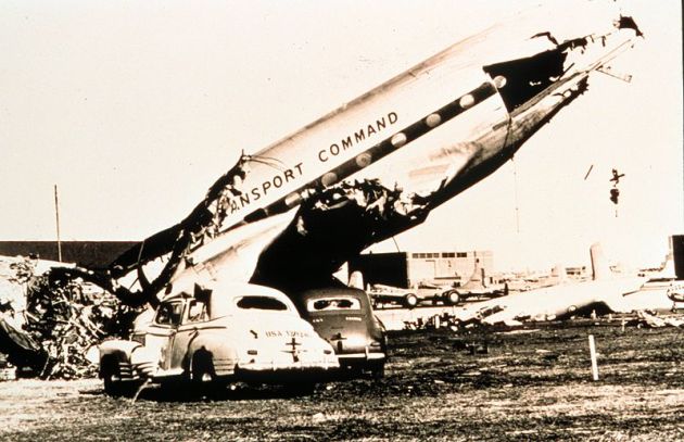
1952. The year it became "legal" for meteorologists to mention the "T-word", tornadoes, in public. Before 1952 there was concern that officials even uttering the word would result in uncontrollable public panic. A successful tornado forecast at Tinker Air Force Base in March, 1948 gradually convinced the Weather Bureau that it was, in fact, possible to predict conditions leading up to twisters. More on the first successful tornado forecast
here. Photo above shows damage from the March, 1948 tornado that hit Tinker Air Force Base, courtesy of
frogstorm.com.
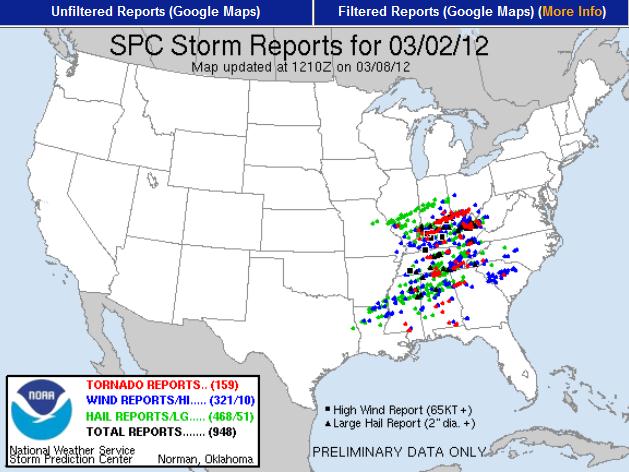
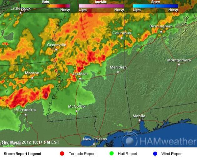
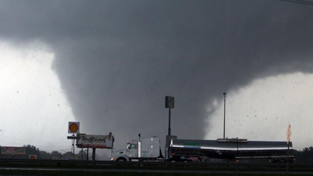
159 (Preliminary) Tornado Reports From Last Friday's Outbreak. It's an incredible number, and will almost certainly be adjusted downward over time (multiple reports of the same tornado from different vantage points?)
SPC has more details.
Deadly Tornadoes Created Strange Seismic Waves. The amazing story from
Our Amazing Planet: "
The deadly storms that struck the Midwest and South last week were so strong that they created seismic waves. One of the twisters that struck southeastern Missouri and southern Illinois on Feb. 29 passed through a seismic detection array that includes more than 100 state-of-the-art digital seismographs across the U.S. heartland. While seismographs have been known to detect seismic activity related to tornadoes, it is highly unusual to have the instruments recording information so close to a tornado, the researchers said."
*
10 Deadliest Tornadoes In U.S. History. Time Magazine has a good overview of America's most catastrophic tornadoes
here.
"Fast-Forward Spring = Earlier Severe Storm Season Northern Latitudes?" It's no slam-dunk, but if we do, in fact, transition into an April-like, or even a May-like pattern by next week, a sudden surge of warmth and moisture may set the stage for an early start to severe storm season. More analysis from
convectiveaddiction.com: "
Spring lovers rejoice! Winter is finally on its way out and the yearly battle with spring has begun, as we have seen with the recent wild weather. March is the most volatile weather month for many locations. If you look up weather records for where you live in March you will find some years have a March that is extremely cold with large amounts of snow, and others have been extremely mild with violent severe weather outbreaks. Few other months can boast such a constant swing between both sides other than March. Where am I going with this? Well, good news actually. We all know its been a pretty mild and easy winter across much of the continental US [as far as winters go] and some of the more weather savvy have been fearing that the other shoe would drop in the spring."
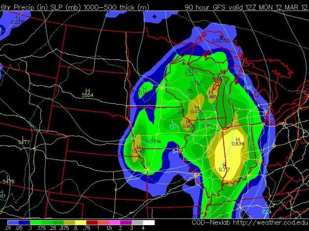
Soggy Monday Blues. A soggy southern storm will brush much of Minnesota with light rain late Sunday into Monday. The GFS forecast above is valid 7 am Monday morning - right now the model prints out .27" of rain on Monday.
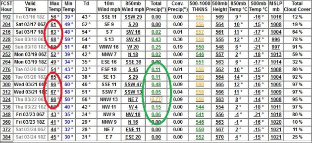
What Happened To "Average". Keep in mind that the average high for this time of year is 37 F. Highs may come close to 60 as early as Saturday, a good chance of a few 60s next week, even 70 next Friday and St. Patrick's Day. The GFS prints out over half an inch of rain for St. Patrick's Day weekend, followed by a more significant (rain) storm between March 20-23.
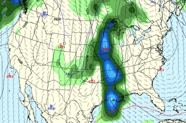
Sliding Into A Wetter Pattern? I sure hope so, for the sake of farmers, and anyone with a boat (lake water levels are down 1-3 feet on some lakes). The GFS forecast map above is valid March 22 - right now the models showing 850mb (3,500 feet) temperatures well above freezing, implying mostly rain.
Analysis: Insurers Forced To Rethink Tornado Coverage. Details from
The Chicago Tribune: "
The deadly start to the 2012 tornado season is forcing insurers to reconsider the risks of coverage in the most storm-prone parts of the United States and industry insiders say they may have to rethink how they handle the underwriting of the reoccurring natural disasters. Unfortunately, homeowners may find themselves either paying substantially higher rates or not having insurance at all, as insurers try to manage their exposure to what is clearly a growing concern by diversifying geographically and tightening their standards. The U.S. insurance industry lost nearly $26 billion on tornadoes and related storms in 2011, higher than the previous record, and insurers have already lost as much as $2 billion this year."
Photo credit above: "
(Blank Headline Received) (ERIC THAYER, REUTERS / March 6, 2012)."
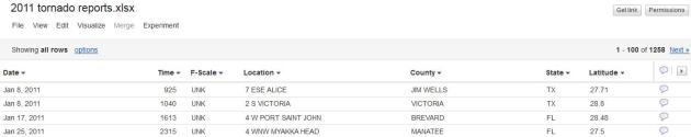
Every Tornado Touchdown Of 2011. Spreadsheet courtesy of
Google Fusion.
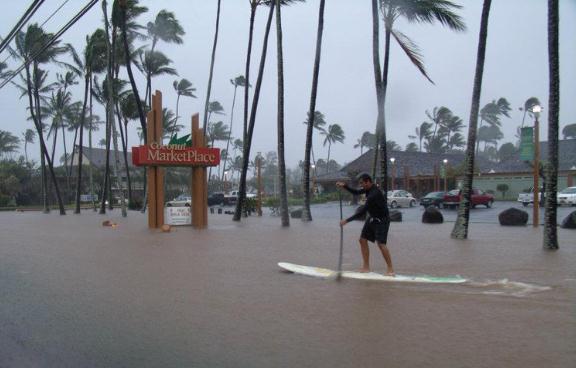
Hawaii Floods: Governor Declares Disaster Area For Oahu And Kauai. Details from the
Los Angeles Times: "
Anyone dreaming of a sunny winter break in Hawaii this week can forget it: Gov. Neil Abercrombie has declared a disaster on the islands of Kauai and Oahu after days of relentless rain that caused flooding, mudslides, waterspouts, hail and dangerously high surf. More rain is expected Friday and Saturday - this after Wainiha, on Kauai, has seen more than 35" of rain since Saturday, with more than 15" dumped on the island's main city, Lihue." Photo Credit: "Heavy rains caused flooding on the Hawaiian island of Kauai, shown here, and also on Oahu. Photo: Jay Armstrong, March 8, 2012.
"
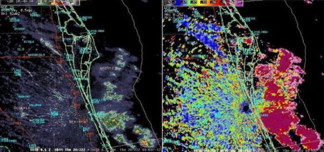
Tracking Florida Smoke On Doppler Radar. Here's a
Facebook post from the Melbourne, Florida office of the National Weather Service: "
The smoke plume from a 100 acre wildfire burning east of Interstate 95, near Port St. John, is currently showing up well on the Melbourne Doppler radar reflectivity image (left frame). The Dual-Pol image to the right shows the correlation coefficient, which distinguishes nicely the showers offshore of Brevard County (dark pink) from the smoke plume near Port St. John (dark blue). Smoke from this wildfire has caused closures along I-95 in this area and there may be continuing visibility issues from smoke mixed with fog into tonight. Keep up to date on road closures by visiting the Florida Highway Patrol website: http://www.flhsmv.gov/fhp/traffic/crs_h407.htm"
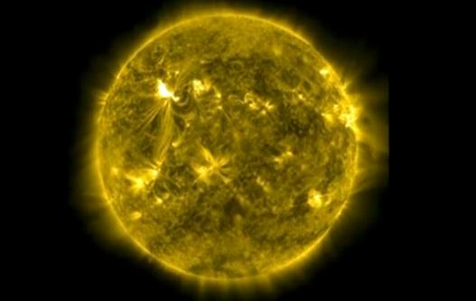
Solar Storm Hits Earth, Unlikely To Reach Severe Levels. Here's an update from
The Edmonton Journal: "
A strong geomagnetic storm hit Earth early Thursday, but the planet's magnetic field appeared to be absorbing the shock and it was unlikely to reach severe levels, U.S. experts said. The storm was nevertheless expected to be the strongest in five years and has the potential to disrupt global positioning systems, airline flights, satellites and power grids, NASA and other U.S. agencies warned. The leading edge of the coronal mass ejection - a burst of hot plasma and charged particles - that erupted from the Sun early Wednesday reached Earth on Thursday at 5:45 am Eastern time, said an update from the National Oceanic and Atmospheric Administration (NOAA)." Image courtesy of NASA.
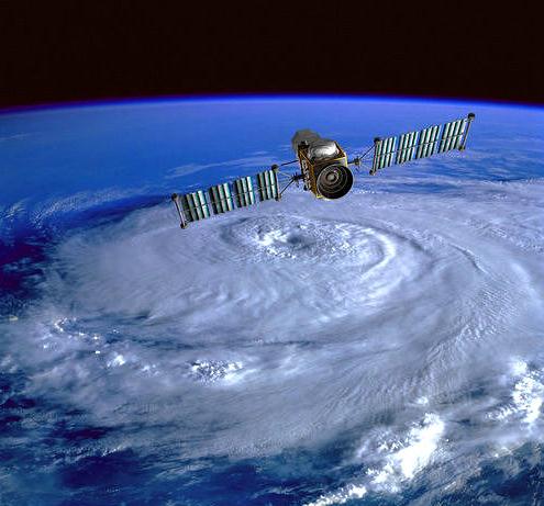
Hurricane Evacuation Planes May Move.
Clickorlando.com has the story: "
Five Gulf Coast states' governors are fighting a U.S. Air Force proposal to move eight planes out of Texas that are used for post-hurricane evacuations. The governors sent a letter to the Obama administration this week in response to proposed Air Force budget cuts. They include moving the Texas Air National Guard C-130 Hercules planes away from a Fort Worth base in two years. The letter signed by governors of Texas, Alabama, Florida, Louisiana and Mississippi says moving the aircraft means it would take days instead of hours to mobilize them in a disaster."
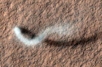
Twister On Mars Captured In Amazing NASA Photo. The gawk-worthy details from
space.com: "
A dust devil on Mars has been caught in the act of tearing across the Red Planet in a spectacular new photo by a NASA spacecraft. The Martian twister rises up on a huge column of dust more than half a mile (800 meters) high in the new image, which was captured by NASA's Mars Reconnaissance Orbiter on Feb. 16 as the spacecraft passed over the Amazonis Planitia region of northern Mars."
Photo credit: "
NASA's Mars Reconnaissance Orbiter snapped this photo of a dust devil on the Red Planet on Feb.16,2012. Credit: NASA/JPL-Caltech/Univ. of Arizona."
Shifting gears...
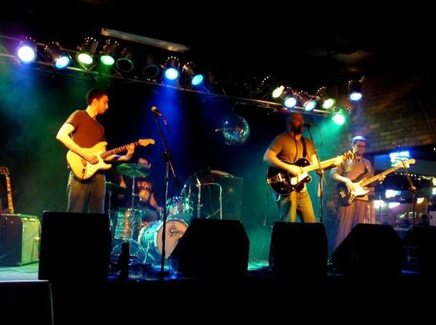
Discovering (Great) New, Local Music. Introducing The "
Lost Wheels". I'm no rocket scientist, but I know good music when I hear it. The Lost Wheels is a new(er) group, funk-rock influence - I heard them at Whiskey Junction and they had a great, unique sound: a fantastic (Australian) lead singer and a creative lead guitarist with an amazing range. The guys on drums and bass are no slouches either, in fact they're at the top of their game. You might want to check them out for yourself. They're playing
The Fine Line Sunday evening, March 18. Check out their
web site - this is one local band you might want to keep an eye on.
"A good friend is cheaper than therapy." - author unknown
Ask Paul. Weather-related Q&A.
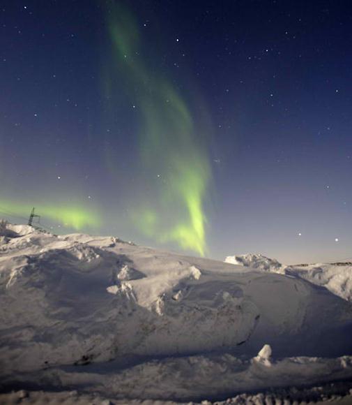
We're excited to see the northern lights tonight! What time should we watch for them tonight the solar storm? And, what direction should we face - north east? north west? straight north?
Thank you for any information!
Kate Wodtke
Kate - there is no way (in advance) to predict when/where the Aurora Borealis will be visible. The Northern Lights are most likely to be visible (and spectacular) after major storms on the sun, which we've seen in recent days, so the probability of a celestial display is (much) higher than usual. Try to get away from the light pollution of the metro area, give your eyes 10-15 minutes to get adjusted to the dark, and you may see some faint, shimmering curtains of green and red off to the north. No guarantees, but it's worth a shot. Check this site (NOAA/Ovation) for updates on the aurora, and you can even sign up for desktop texts from spaceweather.com; if an aurora is underway you can even get a well-timed alerts on your smartphone. Giovanni Cappelli sends this picture from the tundra east of Murmansk, Russia, courtesy of
spaceweather.com.
________________________________________________________________
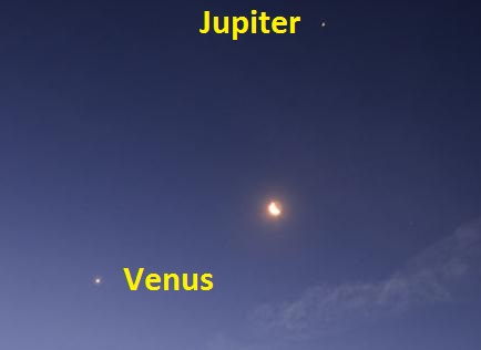
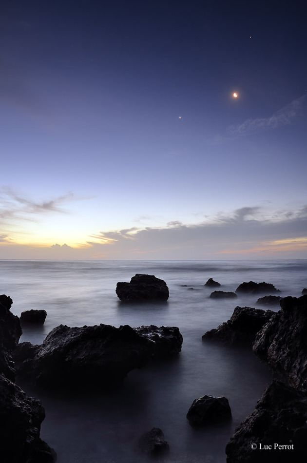
It seems that every night when we go for a walk in the New Hope, Minnesota area we always see 2 bright stars in the western sky. Are they satellites, planets or just plain bright stars?
Thanks,
Mary Leonardson
Mary - those bright objects are planets, Jupiter and Venus (Venus is the brighter of the two, closer to the horizon). The way you can tell they're planets and not stars? They don't twinkle. Thanks for a great question! Photo above courtesy of Luc Perrot and NASA.
_________________________________________________________________
Greetings,
The forecast by Paul for next Wednesday is 70 degrees.
The Accu-Weather forecast for that day is 57 degrees.
The Weather channel forecast for that day is 47 degrees.
It seems unbelievable there could be a 23 degree difference in forecast for the same day 5 days out. How does one explain this?
Terry Kerber, Excelsior
Terry - long range forecasting is extremely tricky, and open to interpretation. In the end it all boils down to which long-range weather model you tend to believe. The ECMWF (European) model has done a slightly better job this winter than the (American) GFS model. So I'm putting more weight into this (milder) solution. Yesterday the ECMWF was hinting at 70 as early as next Wednesday - the latest run is slightly cooler, but still hinting at highs in the mid 60s Wednesday, possibly reaching 70 next Friday and St. Patrick's Day. Right now, based on the latest ECMWF outlook (above, in Celsius), next Friday would appear to be the warmest day, the best chance of sampling 70. But buyer beware - accuracy levels drop off (dramatically) beyond 3-4 days. It's something of a conundrum: there is (some) skill out to about 15-16 days with these models. People
want to know what may happen, the trends looking out 1-2 weeks into the future. So we give it our best shot, pick the models we're leaning towards, and step out onto that shaky limb. With highs in the 50s this weekend into Monday I suspect we'll lose most of the snow left in your yard - meaning next week the sun's energy can go into heating up the air, not melting snow. Bare ground increases the odds of seeing 60s, even a 70-degree high. I go out of my way to talk about "low confidence levels" for long range forecasts; it's more of a
"wish-cast" that far out, but in the end I'm choosing the model I'm most comfortable with and placing a bet. Let's see how this pans out, but there's little doubt (in my mind, at least) that next week will be 20-30 degrees warmer than average, especially from the Twin Cities to the Iowa border.
_________________________________________________________________
Paul,
What day did we have those 4+ inches of slush in Hopkins? I know it took me an hour and 20 minutes to shovel and it was incredibly heavy, but I can't remember what day it was. I'm trying to keep a record of my physical activity for my neurologist.
Thanks, Dodi
Dodi - the only day where we've seen more than 4" in a 24 hour period was back on December 3, 2011. That was our biggest snowfall of the winter, to date. Kind of sums up our sorry winter. Check out the Twin Cities climate data for yourself
here, courtesy of the Minnesota Climatology Working Group.
Paul's Links. Favorite, bookmark-worthy web sites:
1).
High-Resolution Doppler Radar. Full disclosure: this is from one of the companies I'm affiliated with, Ham Weather, so I'm a little bit biased. These maps are free to consumers, and if you have a web site you can sign up for a steady stream of maps (tailored for your needs) for far less $$ than you might imagine. More details on these maps: "
The Precipitation Type Radar is the base reflectivity radar with areas of precipitation split into their respective precipitation types. A base reflectivity radar is a display of echo intensity (reflectivity) measured in dBZ (decibels of Z, where Z represents the energy reflected back to the radar). "Reflectivity" is the amount of transmitted power returned to the radar receiver. Base Reflectivity images are available at several different elevation angles (tilts) of the antenna and are used to detect precipitation, evaluate storm structure, locate atmospheric boundaries and determine hail potential. This image is from the lowest "tilt" angle (0.5°). This means the radar´s antenna is tilted 0.5° above the horizon."
2).
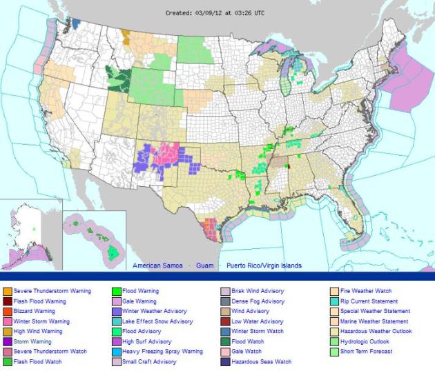
NOAA National Watches/Warnings/Advisories/Statements. This is a handy map from our dear friends at NOAA. You can get a quick overview of where the crap is hitting the fan, and then click on specific areas to drill down, see more detail, even a 7-Day forecast for any town in the nation.
3).
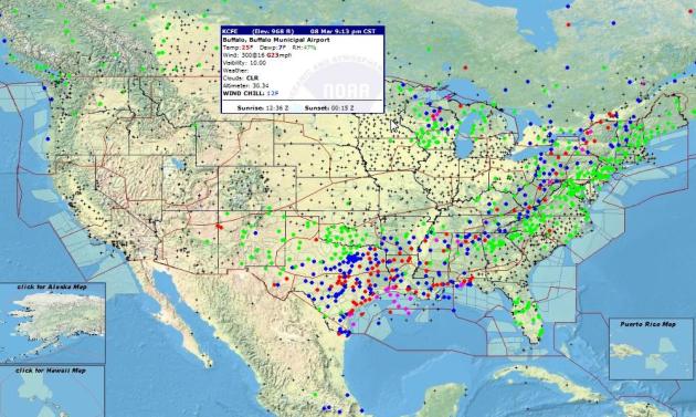
Interactive Real-Time Weather. Here's another great site from NOAA, showing a national Doppler radar mosaic, and thousands of real-time observations from airports around the USA. Hover your cursor over a specific city and the latest conditions pop up. Very useful.
There are no words in the English language to describe what comes next...
Invisible Children. You wonder how something like this can still be going on in the 21st century. This Uganda thug/warlord may be the biggest criminal on the planet right now (and with all the unsavory characters lurking out there that's saying quite a lot). If you have the time check out this
YouTube video, which has seen over 40 million views in under 4 days. Make the time: "
KONY 2012 is a film and campaign by Invisible Children that aims to make Joseph Kony famous, not to celebrate him, but to raise support for his arrest and set a precedent for international justice."
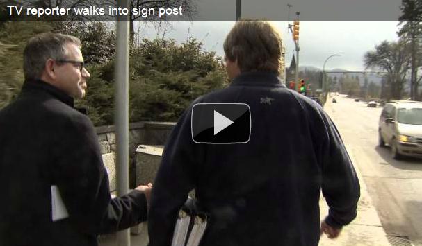
Seeing Is Believing. I think the reporter is ok. Just his pride injured, nothing more. Video courtesy of
thebiglead.com.
VW's New Polo BlueGT: 60 MPG And 140 BHP. The story from
gizmag.com: "
Volkswagen's Polo BlueGT went on show in Geneva this week running a very interesting turbocharged 1.4-litre four-cylinder engine, the first of a new series of engines which shut down two of the engine's four cylinders under light and medium loads (below 4,000 rpm, and at torque outputs of less than 100 Nm). Does it work? You bet 140 bhp, a top speed of 210 km/h (130 moh) and using the seven-speed DSG tranny, 4.5 liters per 100 km (62.8 mpg) consumption and CO2 emissions of 105 g/km.
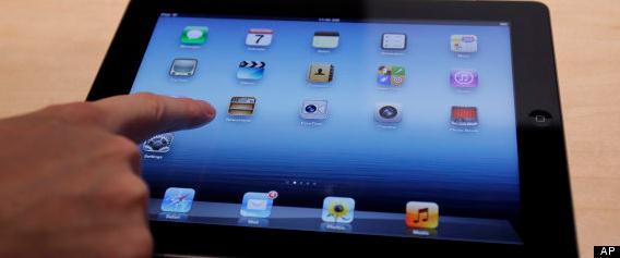
iPad Features: 11 Awesome Things You Need To Know About Apple's New Tablet. Huffington Post has more: "
After months of talk, Apple finally announced the release of its latest tablet device at an event in San Francisco, Calif. on March 7. World, meet the new iPad. (That' right, "iPad." Not iPad 3, not iPad HD, not iPad 2X -- just iPad.) While the device doesn't look too different from its predecessor on the outside, like the iPhone 4S before it, the differences are mainly internal. Flip through the slideshow below to learn more about what latest (and greatest?) Apple iPad has to offer, and tell us: What new iPad feature are you most excited about? Share your thoughts in the comments below!" Photo above: AP.
AppleTV Goes 1080p. The story from
gizmag.com: "
Along with spreading the word about a certain new tablet computer, Apple also used today's media event to unveil the latest version of its Apple TV video streaming system. The big news is that the new device allows users to view content in full 1080p HD, from sources such as iTunes, Netflix, Vimeo and YouTube. It also features a simpler icon-based user interface, which facilitates the viewing of purchased content that is stored on Apple's iCloud service."
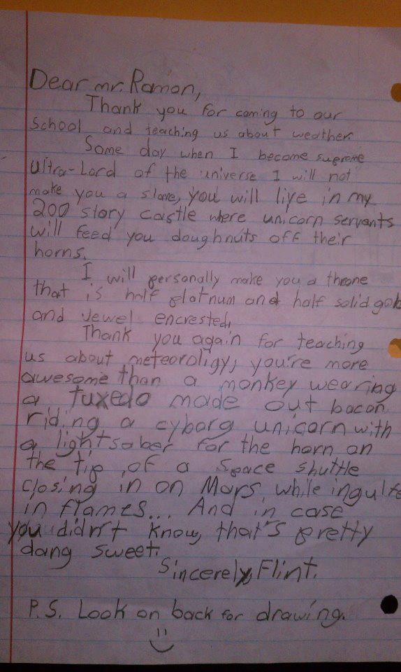
The Most Insane Ever Written By A Child To A TV Weatherman. I've had my share of crazy letters, but nothing quite this...unusual. Details from
happyplace.com: "
If Flint grows up to be a local TV weatherman, we are immediately packing our bags and moving to that city. Think this kid would settle for just putting a pair of Ray Bans on the sunshine graphic? His sunshine graphic would ride a Harley while juggling rescue puppies. Every time a nice day was predicted we'd probably get to see his sunshine graphic disembowel a raincloud graphic with the tusk of a narwhal. In short, a weather report totally demanding that you relocate your family immediately. Oh, and below is Flint's drawing from the back page."
"When you aim for perfection, you discover it's a moving target." - George Fisher
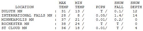
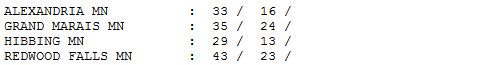
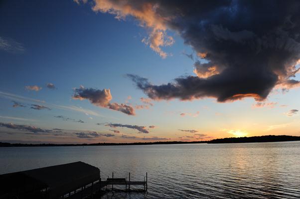
Seasonably Brisk. Yesterday was perfectly average for March 8, within a few degrees of normal. After an early morning burst of wet snow the sun made a cameo appearance, winds gusting as high as 30 mph at times. Statewide highs ranged from 28 at International Falls to 36 St. Cloud, 43 at Redwood Falls.
 Paul's Conservation Minnesota Outlook for the Twin Cities and all of Minnesota:
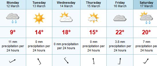
TODAY: Bright sun, light winds. Winds: S 5-10. High: 41
FRIDAY NIGHT: Clear skies - possible Aurora Borealis (no way to know in advance, but worth a look). Low: 36
SATURDAY: Sunny, windy and milder. Typical of April 12. Winds: S 15-30. High: 56
SUNDAY: Clouds increase. Dry during the daylight hours. Rain at night. Low: 39. High: 53
MONDAY: Periods of rain likely, cool and damp. Low: 40. High: near 50
TUESDAY: Sun returns, feels springy. Low: 44. High: near 60
WEDNESDAY: Plenty of sun. Outdoor lunch reommended. Low: 42. High: 66
THURSDAY: Blue sky, still well above average. Low: 45. High: near 60
* Long-range guidance is hinting at more humidity, clouds and even a few showers and T-showers next Friday and Saturday (St. Patrick's Day) with highs ranging from 67-73 F. That would be almost 25-30 degrees above average.
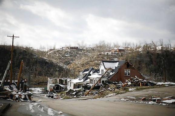
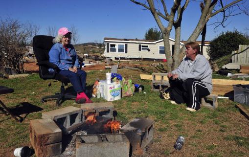
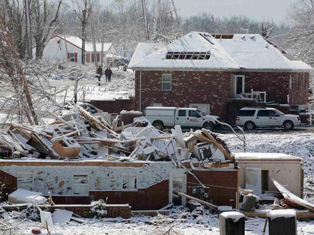
Sitting Ducks. The death toll in trailer parks is disproportionately high - many mobile homes can become airborne when winds exceed 60-70 mph. "Karen Simmons, of Harvest, sits next to a fire to stay warm with her aunt, Sara Mayo, of New Hope, next to Simmons' trailer which was tossed off it's foundation by Friday's tornado, Monday March 5, 2012 in Harvest, Ala. (AP Photo/The Huntsville Times, Eric Schultz)."
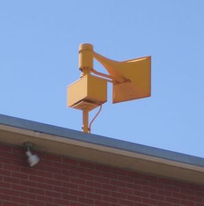
Multiple Safety Nets: the more sources of severe weather information, the better: TV, radio, apps, e-mail alerts, NOAA Weather Radio and sirens (which are only meant for outdoor use). The more sources: the greater the odds you'll receive news of an oncoming tornado in time to take evasive measures.
Tough Tornado Lessons
Do you have a NOAA Weather Radio? It's the only device that will wake you out of a deep slumber when a tornado is heading toward your house at 3 am. Weather warning apps on your smartphone? What about e-mail alerts? Research shows the more "safety nets", the better. Local media does a terrific job, but you may not be in front of a TV the next time skies turn violent.
Last Friday's historic tornado outbreak (SPC reports
159 tornadoes now) had a few take-aways. Research from Illinois University shows 46% of Tennessee tornadoes strike at night, when most people are asleep. Only 16-24 per cent of Minnesota's twisters strike after sunset; that's why you need that NOAA Weather Radio.
Another epiphany: many tornado victims lived in mobile homes. Although it's not official (yet) some authorities are CONSIDERING advising people living in trailers to get into their vehicles, and attempt to drive away from the tornado. Two bad options, but a trailer is no match for an EF-3.
Rumors are true: a taste of May is on the way: 50s this weekend, 60s next week - models hinting at 70 the end of next week. 70 with T-storms on St. Patty's Day? A true meteorological time warp is on the way.
"The magnificence of mountains, the serenity of nature - nothing is safe from the idiot marks of man's passing." - Loudon Wainwright.
Climate Stories....
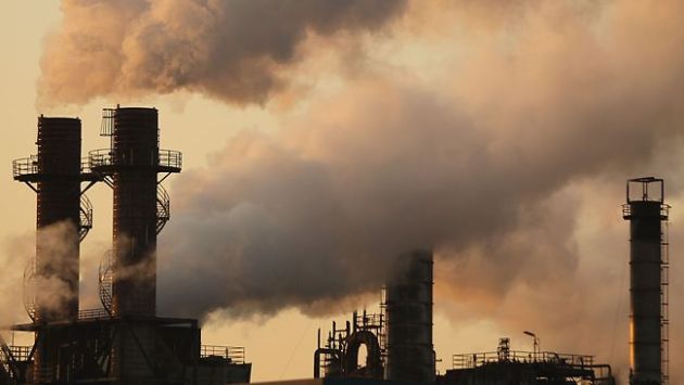
 The Freak Weather That Won't Be Denied.
 The story from
emagazine.com: "
These are trying times in Pendleton Harbor, Texas. During what government scientists say is the worst drought since the Dust Bowl of the 1930s, the water level in Toledo Bend Lake has sunk to its lowest level since it opened in 1969, leaving this subdivision, built on its manmade shores, high and dry. “Where you once were able to drive your boat, you can now mow the grass,” says John Miller, a former park ranger who retired to this relatively verdant spot on the Texas-Louisiana border with his wife Rita five years ago. The couple began visiting the area as the Toledo Bend hydroelectric dam was built half a century ago, a process that created the South’s largest lake and more than 1,000 miles of shoreline filled with rustic cabins, mobile homes and ample fishing."
Astonishing Series Of Midwest Tornadoes May Be Linked To Climate Change. The story from
The National Post: "
NEW YORK — When at least 80 tornadoes rampaged across the United States, from the Midwest to the Gulf of Mexico, last Friday, it was more than is typically observed during the entire month of March, tracking firm AccuWeather.com reported on Monday. According to some climate scientists, such earlier-than-normal outbreaks of tornadoes, which typically peak in the spring, will become the norm as the planet warms. “As spring moves up a week or two, tornado season will start in February instead of waiting for April,” said climatologist Kevin Trenberth of the National Center for Atmospheric Research."
Photo credit above: "
Snow covers tornado damaged homes and the belongs of the victims in the small community of Henryville, Indiana, March 5, 2012. Calm weather gave dazed residents of storm-wracked towns a respite early on Sunday as they dug out from a chain of tornadoes that cut a swath of destruction from the Midwest to the Gulf of Mexico. Photo: REUTERS/John Sommers II."
"
Many of my conservative friends are deeply suspicious of climate change, and they hate carbon taxes and cap and trade. They’re not interested in adapting to a supposedly hypothetical future. Fair enough. Everyone is entitled to an opinion. But these same friends embrace ideas like U.S. energy independence, reducing foreign oil imports, promoting economic growth, protecting our families from harm and improving the U.S. balance of trade. And many of these same friends, while skeptical about climate change, see the wisdom in protecting rain forests and the world’s biodiversity".
- Dr. Jon Foley, Director of The Institute of the Environment at the University of Minnesota, as quoted in a
recent blog post at Andrew Revkin's Dot Earth Column at The New York Times.
Climate Change May Be Affecting The Jet Stream. Here's an interesting story from
The Earth Institute at Columbia University: "
If you have ever looked at a weather map, you’ve a seen picture of the jet stream, that wavy west to east line linking areas experiencing relatively similar weather. In the three dimensional world, jet streams are high altitude westerly winds that occur along the boundaries between air masses of different temperatures. They are driven by the temperature gradient; in the winter, when the gradient is steepest, jet streams are strongest. A new study provides evidence that climate change may be affecting the northern hemisphere jet stream. As a result of climate change, Arctic autumn temperatures have warmed by as much as 5 degrees Celsius (9 degrees F), reducing the temperature gradient between the Arctic and temperate latitudes."
Climate Change Written In Stone. The story from
The Albany Times Union: "
ALBANY — Black, green and red slate — stone found throughout the state and commonly used for landscaping and roofing — tells an ancient story of climate change driven to extremes by oceans, according to research announced Wednesday by the New York State Museum. Ed Landing, state paleontologist and the museum's curator of paleontology, coined the term "global hyper-warming" to describe how oceans, once warmed and expanded by rising temperatures caused by increasing levels of greenhouse gases, crept inland and began driving even more planetary warming."
Photo credit above: "Dr. Ed Landing dissolves rock samples to reveal micro fossils in his lab at the New York State Museum in Albany Wednesday March 7, 2012. (John Carl D'Annibale / Times Union)."
Huntsman On Climate Change, Natural Gas And Competing With China. The story from
Grist.com: "
For a while there, Jon Huntsman was the one Republican presidential candidate willing to deliver the straight dope on climate change. “To be clear,” he tweeted in August, “I believe in evolution and trust scientists on global warming. Call me crazy.” He even argued that climate skepticism could cost the GOP a victory in November: “The minute that the Republican Party becomes the anti-science party, we have a huge problem. We lose a whole lot of people who would otherwise allow us to win the election in 2012.” Envirospraised Huntsman as the heroically rogue elephant." Photo by Gage Skidmore.
We Must Adapt To Climate Change. Canada's
Chronicle Journal has an Op-Ed. Sadly, I agree with the thrust of this argument. A certain amount of warming is already in the pipeline and unavoidable. There will be plenty of money to be made by helping America (and the rest of the world) adapt to a warmer, stormier world: "
THERE IS a fundamental disagreement in this country on the issue of climate change. Most agree with the large majority scientific view that it is caused by man and must be curtailed before it overwhelms our weather. Others cling to the view that climate changes all the time and that we needn’t waste vast sums of money responding to increasingly violent weather because this is just another natural period of climactic upheaval that will settle down soon enough. Governments have a responsibility to decide whom to believe and, thankfully, more of them are siding with science." Photo courtesy of NASA.
It's Time For The Gloves To Come Off On Climate Change. An Op-Ed from
greenbiz.com: "
Prompting action on climate change requires open warfare. Gloves off. If there are rules, they are street rules, i.e. logic is out the window. On the street, it is all about protecting your people. The idea that accurate reporting will change the way anyone thinks or acts on Capitol Hill is ridiculous. It's like planting a seed in Death Valley and expecting it to miraculously sprout into a beautiful carbon-mitigating flower. Not going to happen. Recently, executives at many renewable energy companies have been discussing an opinion piece by Severin Borenstein, a professor of business and public policy at the University of California at Berkeley, who argues (largely correctly) that the Obama administration's linkage of clean energy to jobs and innovation is placing focus on the wrong issue. His argument is simple: the dirty energy industry can just as easily claim that it is creating jobs and innovating, and they wouldn't be lying."
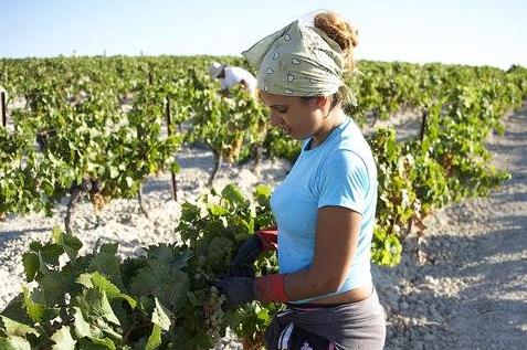
Wine News: Global Warming Warning. Uh oh, when it starts to impact wine production a few more people may perk up and pay attention. The story from
The Prague Post: "
Despite the recent very cold spell, it seems our planet is becoming ever warmer, and this is also affecting viticulture in a number of ways. Not all of them are obvious. In such already torrid parts of the world as the Jerez region of southwest Spain, famous for Sherry, the Napa Valley in California or the Port-producing Douro region in north Portugal, making decent wines from premium grapes is problematic enough. Increased sugar levels in the grapes with a consequent lack in the necessary balancing acidity lead to wines that are not only heavily alcoholic but flabby, with little prospect for successfully laying down. Many think the 14.5 percent alcohol that has become the norm for many California red wines is excessive, far more suited to a fortified wine."
Say It Loud, I'm Warmist And Proud! D.R. Tucker has the story at
Huffington Post: "
Which genius came up with the term "warmist" to describe those who recognize that anthropogenic climate change is a legitimate problem? The website visualthesarus.com defines the term this way: "Among those skeptical that human practices are responsible for global warming, the term warmist has caught on to describe those on the other side of the ideological divide. But Paul McFedries of Wordspy points out that it was originally a neutral label... [A]s arguments over global warming became more polarized, warmist turned into a pejorative, especially popular among conservative pundits during the "Climategate" controversy."


No comments:
Post a Comment