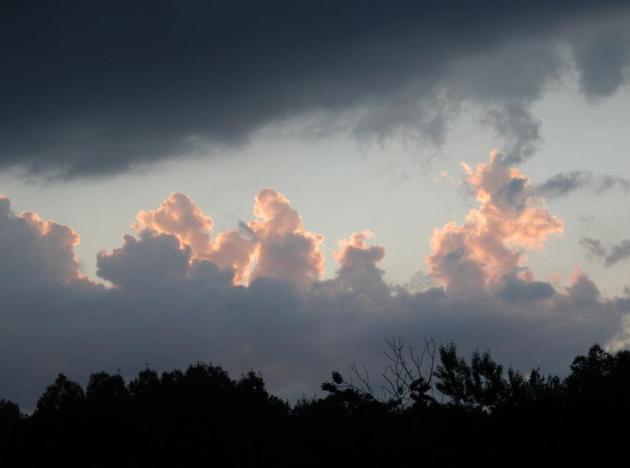
73 F. high in the Twin Cities at 3:38 pm Tuesday.
62 F. average high for April 24.
62 F. high temperature 1 year ago, on April 24, 2011.
4 days above 70 so far in March in the Twin Cities.
8 days above 70 in March, 2012 in the metro area.
Trace of flurries in the metro so far in April, 2012.
1.9" had fallen on the Twin Cities from April 1-24, 2011.

"
I
arise in the morning torn between a desire to improve the world and a
desire to enjoy the world. This makes it hard to plan the day." - Elwyn Brooks White
One More Temperature Correction - Then 70s (and 80s) Next Week.
The latest European (ECMWF) model, which tends to do a better job after
Day 3, shows a dry weekend (storm tracks just south of Minnesota) with
highs in the 50s, but we may be close to 70 by next Tuesday, a few
80-degree highs possible by the end of next week.
105 F. high at Phoenix Monday, a new record - tied for the hottest ever observed in April at KPHX.
113 F. high reported at Death Valley, the hottest April temperature ever recorded.
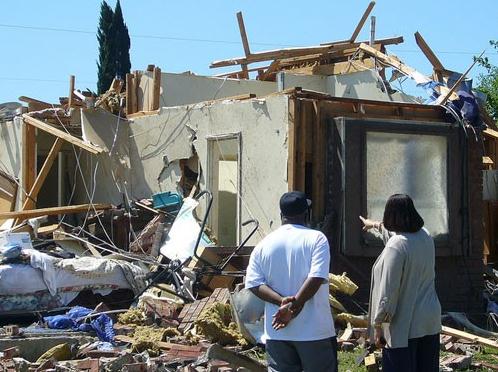
23.2" snow reported at Laurel Summit, Pennsylvania.
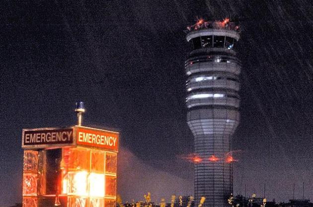
Disaster Emergency declared for parts of western
Pennsylvania early Tuesday due to heavy wet snow, school closings and
power outages. More details from
USA Today.
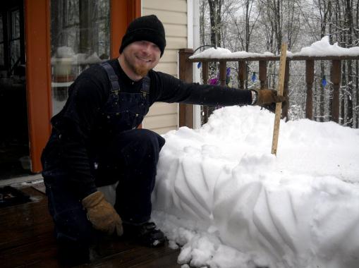
Photo credit above: "
Nick Brogan shows how deep the snow
was on Mallory Babcock's porch on Monday, April 23, 2012, on Armenia
Mountain in Armenia Township, Pa. It measured 13 inches in this spot.
(AP Photo/The Daily Review, Eric Hrin)."
7 am Tuesday: 37 F. at Cross City, Florida - at the same time it was 41 F. at Quebec, Canada
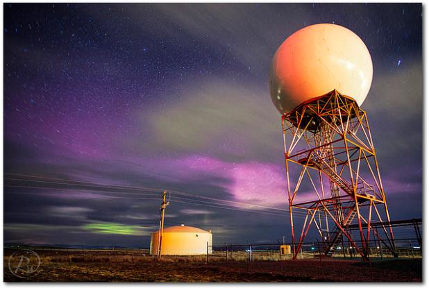
Photo Of The Day: Northern Lights. Here's a great pic of the Aurora Borealis, taken by
Reid Wolcott at the National Weather Service in Riverton, Wyoming Monday night. Details via
Flickr: "
Got
a message and texts from a couple of my co-workers that there was an
Aurora event going on, visible from the office. I was able to rush up
there and grab a few shots before it faded away. This was the best
display I've seen since moving here, hopefully we get a few more
opportunities while the sun is still active!"
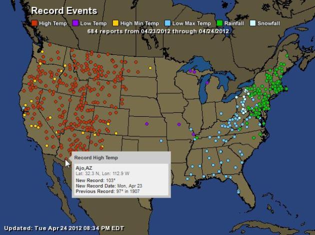
The United (Meteorologically Insane) States of America.
Check out Monday's records: 100-degree heat out west, with 24 hour
snowfall records from West Virginia into western New York. Unreal.
Details courtesy of NOAA - interactive map courtesy of
Ham Weather (one of the Media Logic family of companies).
Hot Facts
Phoenix:
* The high temperature of 105 F. on April 22nd ties the hottest
temperature ever recorded in Phoenix in the month of April (April 20,
1989 and April 29, 1992).
* The 3 consecutive days of 100+ heat hasn't happened during the month of April in Phoenix since 1992.
* All 3 of these days set daily record high temperatures for the
city, but is a far cry from April 1989 when 10 daily record highs were
set during the month.
Salt Lake City:
* Temperatures reached 86 F. at Salt Lake City Tuesday. This broke
the the daily record of 85 set in 1977. That's 3 record days in a row
for SLC!
"
Despite clear indications on weather radar of a powerful
thunderstorm with a possible tornado heading toward the DFW airport,
the issuance of a tornado warning, and a “tornado emergency” airport
weather warning, airline pilots were still caught off guard on taxiways
with full loads of passengers — exposed and vulnerable to a powerful
tornado. The tornado emergency warning for DFW was issued 17 minutes in
advance of the storm, according to the National Weather Service."
- excerpt of an article at Climate Central below focusing on a
continued danger to aviation, pilots and passengers during severe storm
episodes. Photo
credit.
"
A poll due for release on Wednesday shows that a large majority
of Americans believe that this year's unusually warm winter, last
year's blistering summer and some other weather disasters were probably
made worse by global warming. And by a 2-to-1 margin, the public says
the weather has been getting worse, rather than better, in recent years." - from The New York Times and The Pittsburgh Post-Gazette; details below.
"
A warmer Arctic means slower-moving storm systems across the mid-latitudes." - details from Earth Gauge below.
"
With the help of well-oiled politicians, ill-equipped and often
complicit media outlets, and vested interests like the fossil-fuel
industry, climate deniers have tried to portray the evidence for
human-caused climate change as some house of cards – a hoax that’s
teetering on a single hockey-stick graph. In reality, the evidence for
human-caused climate change is more like a vast puzzle, a few pieces of
which come from paleoclimate data like what my colleagues and I studied
in our hockey-stick paper." - climate scientist Michael Mann, in a story at The Energy Collective below.
"
But research by Yale and George Mason universities suggests
Americans are now seeing that the hoax may all be on the climate change
denier side. By a 2-to-1 margin, they say that U.S. weather –
including heat waves, droughts and severe rainstorms – has been getting
worse, rather than better, in recent years." - from an Op Ed at The Climate Daily below.
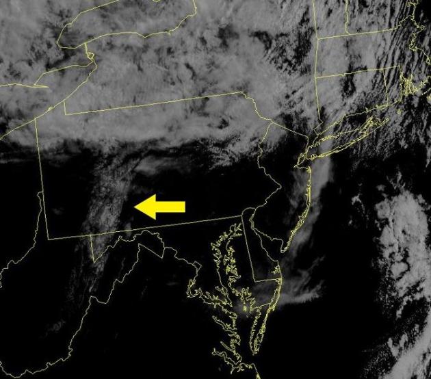
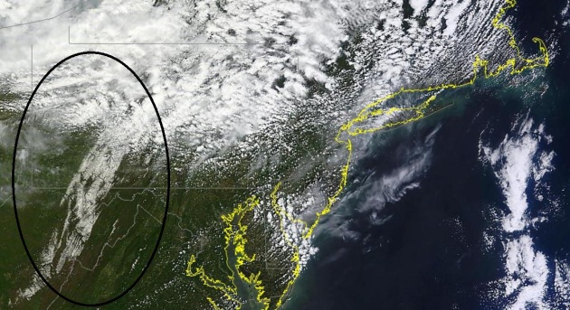
Snow From Space. Almost 2 feet of snow over western Pennsylvania? Good grief. Here's a post from the
Philadelphia office of The National Weather Service: "
An
unusual sight on a late April visible satellite image. The yellow
arrow points to the area of snow that extends southward from the
mountains of western Pennsylvania, across extreme western Maryland and
down into eastern West Virginia."
MODIS 1,000 meter resolution Tuesday image courtesy of NASA.
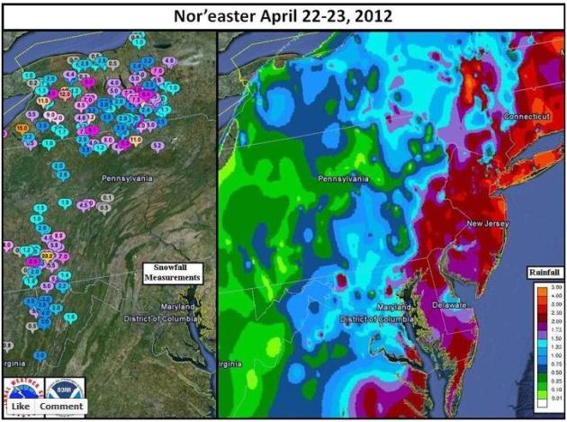
Anatomy Of A Nor'Easter. Check out the 3-5" rainfall
amounts from eastern Virginia into the Philadelphia area, New Jersey
and much of southern New England. Had that been all snow: 2-4 feet.
Details from the Washington/Baltimore office of the National Weather
Service, via
Facebook: "
A regional map of rain and snow fall from the Nor'easter."
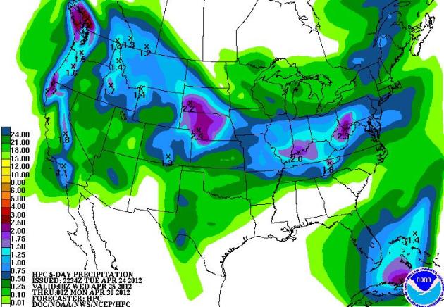
5-Day Rainfall Amounts. Some 2"+ rainfall amounts
are predicted for the Pacific Northwest, South Dakota and Nebraska, the
Louisville, Kentucky area, and western Pennsylvania. The late-week storm
is predicted to pass just south of Minnesota - again.
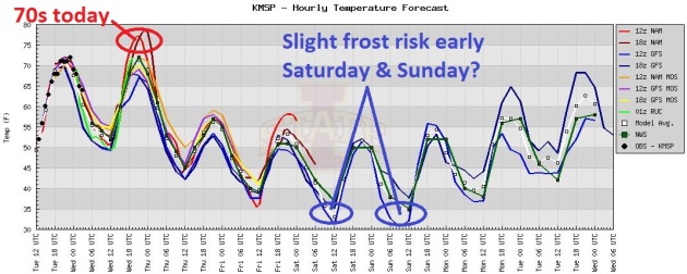
Shorts & Jackets. After one more day of 70s
today temperatures cool off into the 50s the rest of the week, a few
models hinting at a frost for the suburbs Saturday and Sunday morning,
before temperatures recover into the 60s early next week.
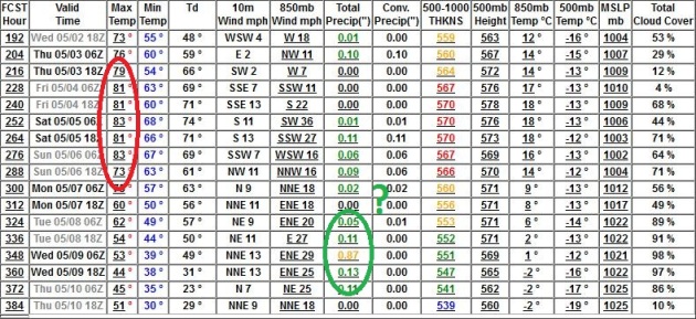
80s Imminent? The GFS has been fairly consistent
hinting at a warm spell after May 2-3, with 3-4 days in a row above 80
F. a very real possibility. Will it stick? Nope. Another cool front tugs
temperatures into the 50s after May 7.
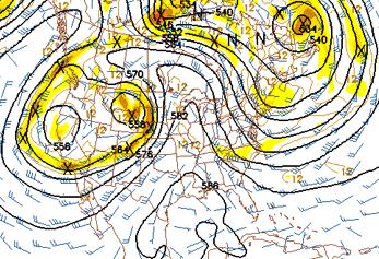
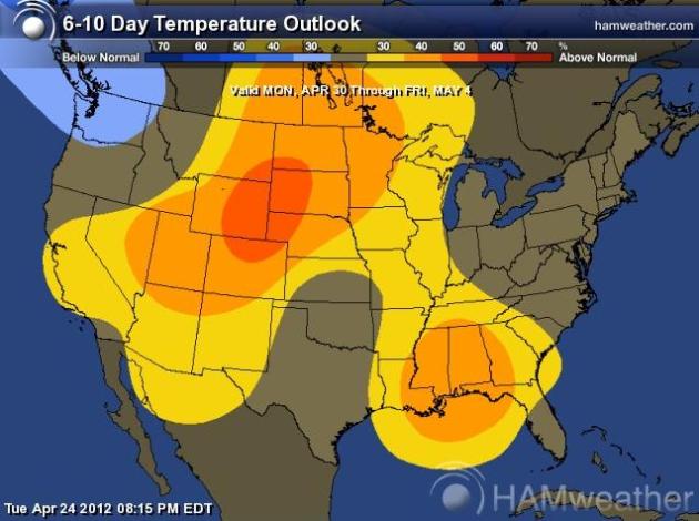
Springy Comeback Next Week. After a cool start
temperatures should mellow into the 60s, possibly a few 70s toward the
end of next week. Map above courtesy of NOAA's Climate Prediction Center
and Ham Weather's new
Aeris graphics.
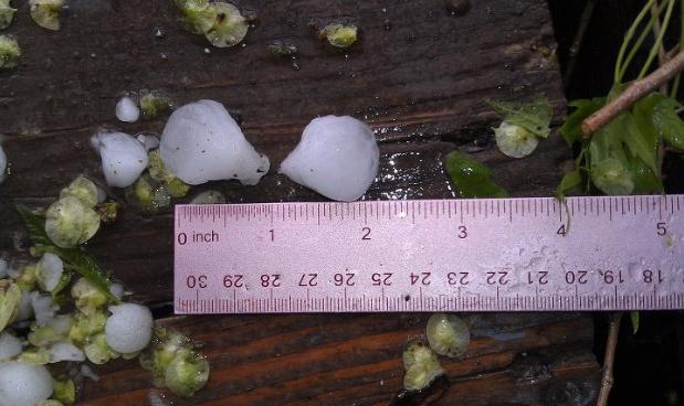 Idaho "Hailers"
. From the Boise, Idaho office of The National Weather Service (
via Facebook): "
Isolated Severe Thunderstorms are producing
large, damaging hail and wind gusts over 70 mph across portions of
eastern Oregon and Southwestern Idaho this afternoon. These hail stones
were photographed near Caldwell."
Critical Flaws Bared In Aviation Tornado Warning System. Another interesting article from Andrew Freedman at
Climate Central; here's an excerpt: "
One
year ago, a violent tornado struck Lambert-St.Louis International
Airport, exposing hundreds of passengers to danger from flying debris in
the concourses as well as onboard aircraft sitting on the tarmac.
Despite a half-hour heads up from the National Weather Service, the airport authority never warned passengers
of the approaching twister, and the tornado warning was not relayed to
pilots either. Damage to one of the concourses was so severe — the
EF-4 tornado peeled away a section of the roof from the one of the
concourses and blew out the large windows in the main terminal — that
repairs were only completed earlier this month.
The St. Louis tornado was supposed to be a wakeup call for the aviation
and weather communities. Yet three weeks ago, the same perilous
scenario was repeated at a different airport, this time at Dallas-Ft.
Worth International, the eighth-busiest airport in the world.
There, a severe thunderstorm on April 3 that was showing signs of
producing a tornado tracked directly over DFW, and while airport
officials succeeded in warning passengers in the concourses and ushering
them to safety, there are indications that there was a failure to
inform pilots of the severity of the approaching storm."
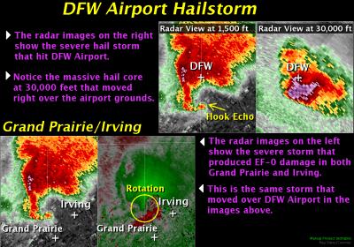
Graphic credit above: "
Radar images and explanation for
the tornadic thunderstorm that struck DFW Airport on April 3, 2012.
Credit: NWS Dallas. Click on image for a larger version."
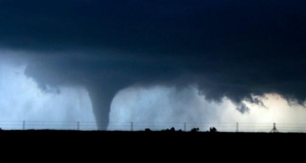
Storm-Chasing Proves To Be An Increasingly Popular Pasttime. If you have an itch to chase tornadoes (or have tornadoes chase you) you'll want to read this article from
The Columbia Daily Tribune; here's an excerpt: "
No
doubt about it, University of Missouri senior Dustin Mazzio got some
pretty impressive photographs and video footage of a twister in Kansas
last weekend. A lot of other storm chasers did, too. A YouTube search
for Kansas tornadoes brings up dozens of videos from the April 14
outbreak. There were so many thrill seekers chasing storm clouds with
camera phones that Kansas safety officials have complained about
traffic snarls, with one official calling the situation "outrageously
stupid." The thing is weather spotters and chasers are extremely helpful
to the National Weather Service, said Robb Lawson, a meteorologist
with the service's Wichita, Kan., office."
Photo credit above: "
University of Missouri student Dustin Mazzio captures a tornado on camera while storm chasing in Kansas."
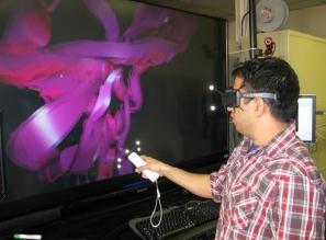
UW Student Hopes To Add New Dimension To Weather Research. 3-D weather? That rings a bell. Check out this story from
trib.com:
"For centuries, scientists have relied on the same fairly humdrum
techniques to understand our planet’s weather: taking measurements, then
crunching numbers. But with the help of University of Wyoming computer
science graduate student Ashish Dhital, weather researchers may soon
be able to move with a tornado twirling across the plains, or watch a
fog bank roll in from just about any viewpoint they could hope for.
Dhital has been chosen as a summer intern this year in the Parallel
Computational Science (SIParCS) program at the National Center for
Atmospheric Research in Boulder, Colo. While there, Dhital will focus
on developing computer programs that can turn raw weather data into
interactive 3-D animations.
Photo credit above:
Ron Podell | UW Public Relations. "University
of Wyoming computer science graduate student Ashish Dhital has been
chosen as a summer intern this year at the National Center for
Atmospheric Research in Boulder, Colo. While there, Dhital will focus
on developing computer programs that can turn raw weather data into
interactive 3-D animations."
Economists Point To Weather As A Key Driver. When in doubt, blame the weather. Only this time there may be more than a hint of truth to that claim. More details from The Shreveport Times: "
When
in doubt, blame it on the weather. It's human nature to want to arrive
at an understandable explanation to everything that happens in the
world. Rather than feeling like it's all random, we want to know why
the market went up or why bats hang upside down or why white is the
most popular auto color. Having no clue about the "why" of things leaves
us feeling very vulnerable.The recent employment report is no
different. The government said the economy added 120,000 new jobs in
March; however, that was well below the 210,000 increase expected by
surveys of economists. So, to what did some economists attribute the
smaller than expected increase? Believe it or not — the weather!"
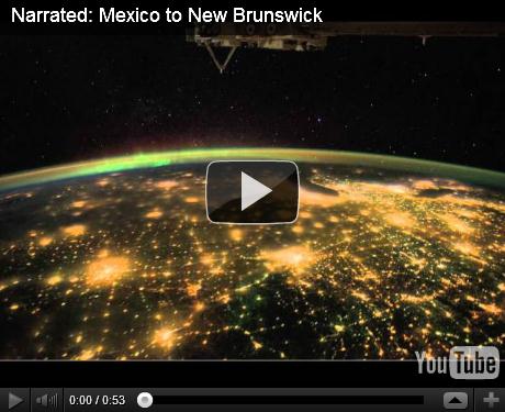
Northern Lights (from 200+ miles above the ground). Check out this spectacular
YouTube clip, courtesy of NASA: "
This
previously uploaded video has now been enhanced by adding narration
from a Crew Earth Observations team member, Justin Wilkinson. This video
was taken by the crew of Expedition 30 on board the International
Space Station. The sequence of shots was taken January 30, 2012 from
06:13:36 to 06:23:09 GMT, on a pass from northern Mexico to northwest
New Brunswick. This video begins looking northeast over Texas, where
cities like San Antonio, Houston, and the Dallas/Fort Worth area can be
seen. Continuing northeast over the Great Plains states, cities like
Oklahoma City, Kansas City, and St. Louis can be easily distinguished.
The pass continues over the familiar shape of the Michigan Peninsula,
with Chicago at the south edge of Lake Michigan. As the ISS continues
northeast, the Aurora Borealis can be seen over Canada."
Research: Millenials Rarely Interact With Brands On Facebook.
This could be a problem for FB - younger users use it to connect (with
friends) but not so much with favorite brands. Details from
Penn State Live: "
UNIVERSITY
PARK, Pa. -- Millennials rarely visit brand pages on Facebook even
after they become their “fan.” That’s what research by Marcia DiStaso,
an assistant professor of public relations in the College of
Communications at Penn State, Tina McCorkindale, an assistant professor
of communications at Appalachian State University, and Hillary Fussell
Sisco, an assistant professor of public relations in the School of
Communications at Quinnipiac University found. The results of their
work were presented during the International Public Relations Research
Conference. The three researchers surveyed 18- to 29-year-old
participants on the three university campuses and found 86 percent of
the millennials access Facebook every day and 75 percent have “liked”
an organization. However, while millennials might initially connect
with an organization, 69 percent percent of respondents reported they
rarely or never visit those pages again."
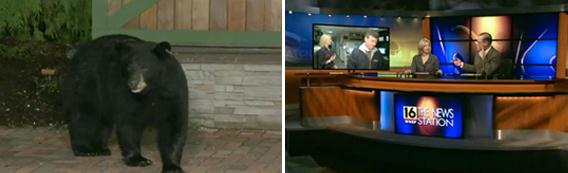
Bears Invade WNEP During 11 pm Newscast. Full
disclosure: I got my start at Channel 16, WNEP-TV, serving the Twin
Cities of northeastern PA: Wilkes-Barre and Scranton. It's here that
"backyard weather" was born, for better or worse. Check out this close
call from
TVSpy.com: "
WNEP had some unexpected visitors during its 11 p.m. newscast on Monday. Just before meteorologist Kurt Aaron
was to appear live from the station’s weather backyard on Monday
night, four bears (one mother and three cubs) descended on the outdoor
space. “I ran like I stole something,” Aaron said during the newscast,
after seeking safety indoors. “No offense, but I don’t want to be
doing the weather with four bears.” Video inside…"
Career Advice From Robin Meade: "Don't Make The Mistake Of Always Looking For The Next Job."
Amen. I couldn't agree more. If you're in in a good situation where you
like the people you're working with, management isn't too much of a
pain in your butt, and there's an opportunity for (internal)
advancement, stay put. Ride the wave. The grass is NOT always greener on
the other side. I speak from personal experience. More from
TVSpy.com: "
In the first part of mediabistroTV’s three-part “Media Beat” interview with HLN’s Robin Meade, the former WJW, WCMH, WSVN, and WMAQ
anchor offers advice about making it in TV news. “Don’t make the
mistake of always looking for the next job,” Meade warns, “so much so
that you’re not learning in your current position.” Meade also talks
about her music career and describes how she’s been able to maintain
her 18-year marriage while working the crazy hours of a morning anchor."
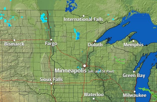
Trying To Keep My (Cartographic) Sense Of Humor.
Some people aren't aware of the friendly rivalry between Minneapolis and
St. Paul. The first month I started at KARE-11, March of 1983, the News
Director pulled me aside and told me "Paul, don't ever mention
Minneapolis...or St. Paul. It's "Twin Cities" We don't play favorites
here." Got it. Recently our developers created some new radar maps with
just Minneapolis. Big mistake. I asked them to change it to "Twin
Cities". Here is what I got back. Nice.
"
Enjoy when you can, and endure when you must." - Johann Wolfgang von Goethe
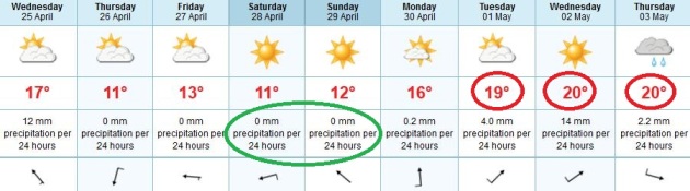
Paul's Conservation Minnesota Outlook for the Twin Cities and all of Minnesota:
TODAY: Mild with more clouds than sun, an isolated T-shower possible. Winds: S 10-15. High: 73
WEDNESDAY NIGHT: Evening thunder, then clearing late. Low: 46
THURSDAY: Bright sun, cooler breeze. High: 58
FRIDAY: Sunny north, clouds increase southern Minnesota. Low: 42. High: 55
SATURDAY: Storm tracks south. Some sun expected - still cool. Winds: NE 10. Low: 40. High: 53
SUNDAY: Early frost central/northern MN? Sunnier, still too dry. Winds: SE 5-10. Low: 37. high: 56
MONDAY: Sunny start - clouds increase, slightly milder. Low: 39. High: 61
TUESDAY: Warmer, sticky with T-showers possible. Low: 48. High: near 70
* a string of 70s are likely next week, even a few 80-degree highs the latter half of next week.
Thunder Potential
Take a bow. You live in one of the 2-3 most
extreme states, in a United States that experience more severe weather
than any other nation on Earth. On average we experience about 35 days
that are potentially life-threatening: tornadoes, extreme lightning,
flash floods, blizzards, wind chill, etc. America's diverse geography
brews up a smorgasbord of airmasses that often converge on Minnesota.
Last Saturday brought snow up north,
tornadoes west. At the rate we're going April may wind up cooler than March. Never a dull moment.
It helps to know we're not alone. Monday brought
23.2 inches of snow to Laurel Summit, Pennsylvania. Meanwhile Phoenix
saw a record high of 105; 113 at Death Valley, hottest ever recorded in
April.
70-degree air surging north sparks T-storms
today, the risk of anything severe slim. Cooler air pushes south, highs
in the 50s late week - but frost-free in the metro area.
Not sure whether to cheer (or weep) but our
late-week storm will probably pass south of Minnesota; weekend highs in
the 50s under a mostly-blue sky. Expect 70s, even a few 80s from late
next week into the first weekend of May.
No guarantees, but you may want to look for the Northern Lights the next few nights.
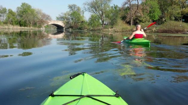
* photo of Tuesday kayaking on Lake of the Isles courtesy of
WeatherNation TV meteorologist Aaron Shaffer
"
We shall require a substantially new manner of thinking if mankind is to survive." - Albert Einstein
Climate Stories...
In Poll Many Link Weather Extremes To Climate Change. Here's an excerpt of a story from The New York Times and the
Pittsburgh Post-Gazette: "
Scientists
may hesitate to link some of the weather extremes of recent years to
global warming -- but the public, it seems, is already there. A poll
due for release on Wednesday shows that a large majority of Americans
believe that this year's unusually warm winter, last year's blistering
summer and some other weather disasters were probably made worse by
global warming. And by a 2-to-1 margin, the public says the weather has
been getting worse, rather than better, in recent years. The survey,
the most detailed to date on the public response to weather extremes,
comes atop other polling showing a recent uptick in concern about
climate change. Read together, the polls suggest that direct experience
of erratic weather may be convincing some people that the problem is
no longer just a vague and distant threat."
Climate Fact: Changes In Arctic Sea Ice Are Affecting U.S. Weather.
Is melting of Arctic ice triggering a meteorological domino effect that
is, in turn, slowing down weather systems across North America,
resulting in drier droughts and heavier rain events, especially over the
southern and eastern USA?
Earth Gauge has more details: "
Spring
is the time of year when the Arctic comes out of its long, dark winter
and the sea ice that covers most of the Arctic Ocean in winter begins
its annual melt. This melting continues through the warm summer months
until the sea ice reaches its minimum extent in September. Then, the
ice begins to grow back throughout the winter until it reaches its
maximum extent in late February or early March. Over the past few
decades, the Arctic has warmed approximately twice as fast as the rest
of the Northern hemisphere which makes ice harder to grow in the winter
and easier to melt in the summer. Today, the Arctic’s average sea ice
minimum is approximately 1.3 million square miles smaller than it was
at the beginning of the 1980s – 1.3 million square miles is enough ice
to blanket most of Europe. Larger areas of the Arctic Ocean are exposed
to the sun’s energy for longer periods the year, which allows it to
release its surplus energy into the atmosphere. This affects the
general circulation of the atmosphere in two distinct ways.
• First, the temperature differences create a pressure
gradient between the mid-latitudes and the poles. This pressure
gradient creates strong upper-level eastward winds that during most of
the year pull storm systems away from the United States at a rapid
speed."
Correction: Climate Change Is A Fact. Here's an excerpt of a story at
The Huffington Post: "
If I could start a movement of a STOP SOPA
nature, it would be to get every newspaper in the world to lead their
publications on the same day with the same banner headline: CLIMATE
CHANGE IS A FACT. Every news network would run a lower third stating the
same thing for 24 hours. Because we need to set the record straight,
once and for all, and it is a correction that is decades overdue.
(Sunday) was Earth Day;
since 1970 this date has been dedicated to appreciation and increasing
awareness of the planet's natural environment. But the scientific
community has been aware of climate change and the conditions that bring it about for much longer than four decades.
Scientists recognized the greenhouse effect in the early 19th century
and tied it to the paleoclimate. Calculations in the 1950s became
increasingly convincing, and by the '70s and early '80s, consensus among
experts was completely clear: human activity on a global scale was
warming the climate."
Michael Mann: The Danger Of Climate Change Denial. Here's an excerpt of an Op Ed at
The Energy Collective: "
As
a climate scientist, I have seen my integrity perniciously attacked,
politicians have demanded I be fired from my job, and I’ve been subject
to congressional and criminal investigations. I’ve even had death
threats made against me. And why? Because I study climate science and
some people don’t like what my colleagues and I have discovered. Their
attacks on scientists are part of a destructive public-relations
campaign being waged in a cynical effort to discredit climate science.
My work first appeared on the world stage in the late 1990s with the
publication of the third assessment report of the Intergovernmental
Panel on Climate Change, which featured what is now popularly known as
the hockey-stick graph. Using what we call proxy data – information
gathered from records in nature, like tree rings, corals, and ice cores –
my co-authors and I pieced together the puzzle of climate variability
over the past 1,000 years. What we found was that the recent warming,
which coincides with the burning of fossil fuels during the Industrial
Revolution, sticks out like the blade of an upturned hockey stick."
Climate Change Is A Human Rights Issue - And That's How We Can Solve It. The story from
The Guardian: "
Global climate-change talks
often resemble the scene of a traffic accident. Multiple voices shout
each other down in a bid to tell their own version of events. What is
the real damage, how quickly must it be repaired, and who should foot
the bill? But the real concern is not that the debate is congested and
gridlocked; it is that the current clamour masks a deeper failing,
namely to identify an honest starting point. In Prosperity Without Growth, the economist Tim Jackson
convincingly expounds the myth of "absolute decoupling" of emissions
from economic growth. The growth of emissions can be slowed, relative to
the growth rate of the economy. However, emissions cannot conceivably
be stalled or reversed while the economy continues to expand, however
great the carbon-saving technologies of the coming years."
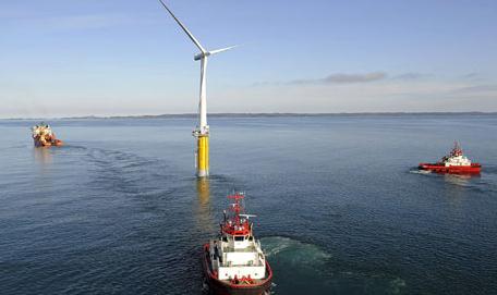
U.S. And U.K. To Collaborate On "Floating" Wind Turbines. Here's an interesting concept from
The Guardian: "
The UK and US will work together to develop "floating" wind turbines to harness more offshore wind power at a potentially lower cost, the government said on Monday. Before this week's clean-energy meeting of ministers
from 23 countries in London, the government announced it will
collaborate with the US in developing wind technology to generate power
in deep waters that are currently off-limits to conventional turbines.
In order to exploit the UK's huge wind resource, which accounts for
about one-third of Europe's offshore wind potential, new technology is
needed to access waters between 60 and 100 metres deep: too deep for
turbines fixed to the seabed, but where wind speeds are consistently
higher."
Photo credit above: "
A floating wind turbine with a capacity of 2.3MW, about 12km south-east of Karmøy, Norway. Photograph: StatoilHydro."
Opinion: Wacky Weather Shifting Voters Away From GOP's Climate Stance. Here's a portion of an Op Ed at
The Daily Climate: "
Global
warming could prove fatal to the GOP this November – or in the near
future. Why? A large majority of Americans now say unequivocally that
global warming intensified the drought, deluge and scorching heat
afflicting mostly Republican-leaning states the past two years,
according to a new study. Meanwhile, Republican congressional hopefuls
and Mitt Romney have hitched their election bids to climate change
skepticism, siding with Oklahoma Sen. James Inhofe, who calls global
warming “the greatest hoax ever perpetrated on the American people.”
But research by Yale and George Mason universities suggests Americans
are now seeing that the hoax may all be on the climate change denier
side. By a 2-to-1 margin, they say that U.S. weather – including heat
waves, droughts and severe rainstorms – has been getting worse, rather
than better, in recent years."
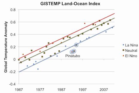
About The "Lack Of Warming". Here's an excerpt of an interesting post from
The Houston Chronicle: "
So
we see a couple of recent La Niñas have caused the recent global
temperature trend to level off. But be honest: doesn’t it seem likely
that, barring another major volcanic eruption, the next El Niño will
cause global temperatures to break their previous record? Doesn’t it
appear that whatever has caused global temperatures to rise over the
past four decades is still going strong? So about that lack of warming:
Yes, it’s real. You can thank La Niña. As for whether this means that
Tyndall gases are no longer having an impact: Nice try."
Graph credit above: "
GISTemp global temperatures, with
trends for El Niño, neutral, and La Niña years computed separately.
Pinatubo years are excluded." Courtesy John Nielsen-Gammon and The Houston Chronicle.


No comments:
Post a Comment