56 F. average high on April 12 at KMSP.
68 F. high temperature on April 12, 2011.
6" snow fell on April 12, 1962.
1.61" rain predicted for MSP between today and Monday morning at 7 am.
30-40 degree temperature drop from Sunday afternoon to Monday evening?
Snow flurries possible in the metro by Monday PM (probably no accumulation locally - but a few inches of slush can't be ruled out from Crosby and Aitkin to the Duluth area). That should cheer people up.
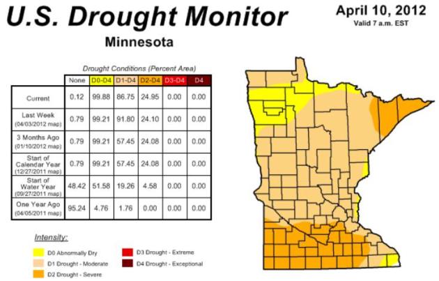
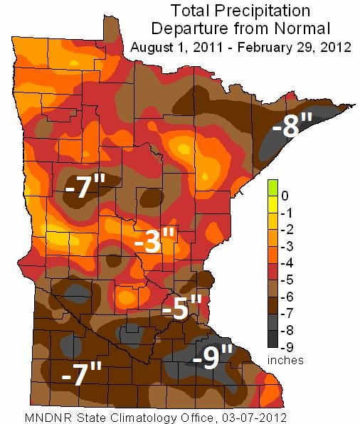
- 6.4". Since September, 2011 the Twin Cities metro is running a greater than 6" rainfall deficit. Source: Pete Boulay, Minnesota Climatology Working Group.

One Crazy 7-Day. Check out the ECMWF predicted highs for the next 7 days. That's celsius, btw. We may top 70 Saturday, near 70 Sunday, then we go over a cliff Monday - a 30-40 degree temperature tumble. The European model is predicting a high of 35 on Monday, which may be extreme, but the trend is undeniable. The weekend feels like May. Monday may feel like late February.
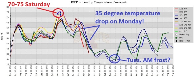
Wild Temperature Swings = Wild Winds. Going from low to mid 70s Saturday to 30s Monday will whip up sustained north/northeast winds of 20-30 on Monday, with higher gusts. Monday may meet the definition of lousy, with a mix of rain and snow showers. Some recovery is likely later next week - the ECMWF hinting at upper 60s again by Thursday.
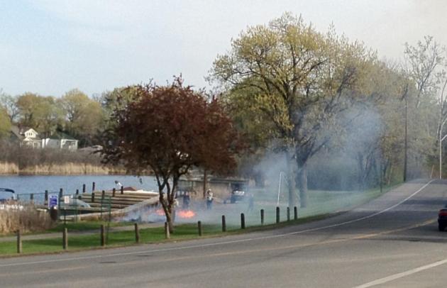
Small Brushfire In Tonka Bay. I had to do a double-take, a small fire on my commute Thursday. It didn't look like a controlled burn to me, next to a small marina near the Tonka Bay Town Hall. odd.

50,000 dams, approximately, worldwide.
60% of the world's wetlands have vanished in the last 100 years. Water info source: Blue Gold documentary.
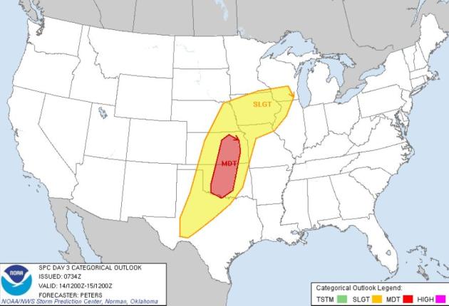
Major Tornado Outbreak On Saturday? SPC is predicting a moderate risk over the Central Plains, a possibility of large, violent, long-lasting tornadoes from Oklahoma City and Tulsa to Wichita, possibly Kansas City. A few isolated severe storms are possible over Iowa - I wouldn't be surprised to see a few hail-producing storms brush far southern MN late Saturday. Source: SPC.

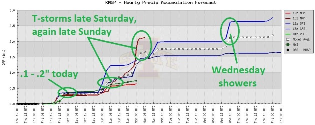
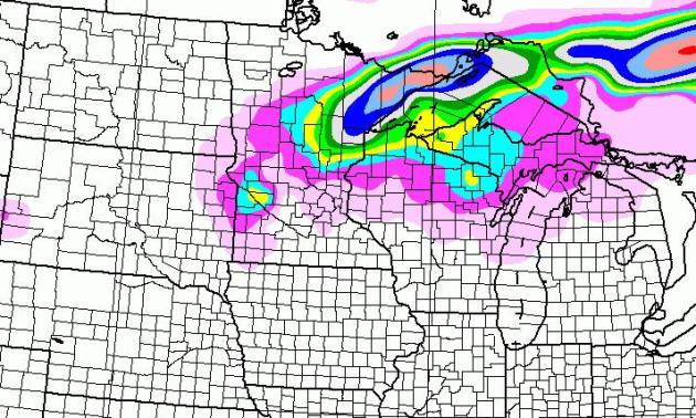
Putting A (Minor) Dent In The Drought? I'll believe it when I see it. NAM prints out 1.61" by Monday morning, and all the models show a few waves of showers and heavier thunderstorms over the weekend. Rainfall today should be light and stratiform/steady. More convective, showery rain arrives over the weekend, with potentially heavy T-storms Saturday and Sunday - timing is tricky, but the heaviest rains may come at night with a warm frontal boundary lurking nearby. Monday precipitation may be a mix of (mostly) rain and a little wet snow - just to shake us up and appreciate spring even more.

An R-Rated Outlook For Monday. With air (and ground) temperatures above freezing I doubt any snow will stick in the metro Monday, but if you're driving up I-35 toward Duluth you may run into a few inches of slush, especially Monday night, after dark. I'm just the messenger. Any snow that might fall Monday will be gone by midday Tuesday. The sun is too high in the sky for any snow to linger on green lawns for long.

Half Of Iowa's Wine Grape Crop Damaged. A freeze was reported as far south as Des Moines and Chicago. Details from The Des Moines Register: "An unusually early start to Iowa’s grapes during the March warmth proved to be the undoing of much of the crop, as about half f Iowa’s grapes may have been damaged in the frost this week, according to Iowa State University viticulturist Mike White. All is not lost, however. White said that Iowa’s grape plants produce a secondary bud that can generate up to 50 percent of the yield of the primary bud."
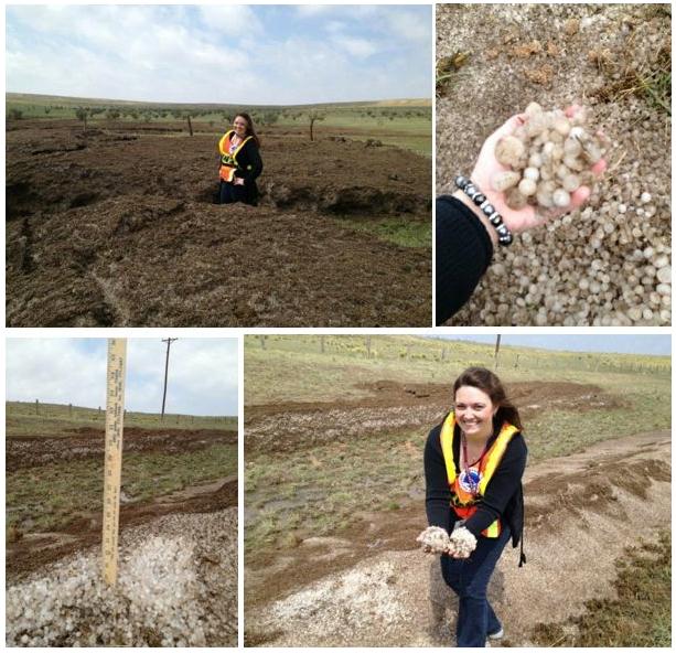

"So why does it look so much like mud? The storm was barely moving at all and managed not only to dump some serious hail, but over 3 inches of rain. Flash flooding quickly ensued. The flood waters managed to scoop up a lot of the hail that had accumulated… leading to the 4 ft. drifts. Remember that much of West Texas remains in a drought too, so a lot of dust on the ground “dirtied up” the hail pretty quickly. The Capital Weather Gang also mentioned that New Mexico (Union County) once saw 15-20 ft hail drifts in 2004. Insanity. In the end, this is a recipe consisting of two ingredients: flash flooding and hail."

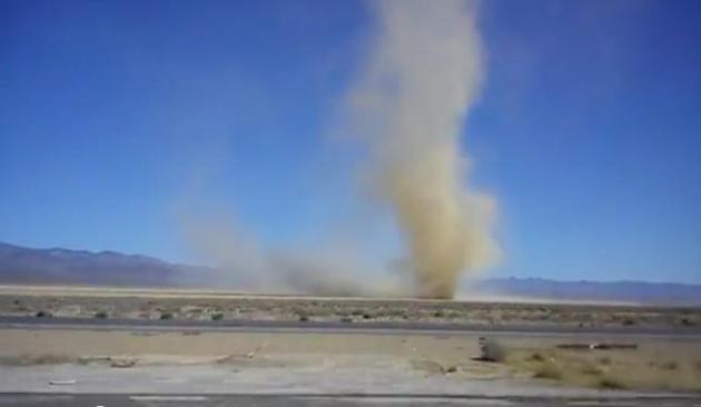
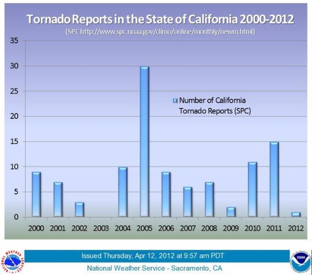
How Rare Are Tornadoes In California? A rare EF-1 tornado touched down near Stockton, California Wednesday, as reported by the L.A. Times. Here's a good (FB) post from the Sacramento office of the NWS: "According to the Storm Prediction Center’s tornado data and climatology, here are the tornado reports archived per year for the entire state of California thus far (2000-2012). The majority of the tornadoes reported were found in the Central Valley or in southern California near the coast, in which surface wind convergence is more favorable. Although these tornadoes are considered weak (EF0 – EF2), it is not atypical for California to have a few tornadoes per year. The 2000-2010 tornado average for the state is around 8 tornadoes per year."

Changeable Weather Expected For The Boston Marathon. Well, if the weather isn't perfect I guess I won't be running again this year. Too bad - I was really looking forward to it. Bill Deger from AccuWeather has the synopsis: "The 116th running of the Boston Marathon is this upcoming Monday, and the forecast is shaping up to be a tricky one. Even with the uncertainty, the gamut of weather conditions possible that morning looks favorable for participants, but possibly less so for some spectators. "There is likely going to be a backdoor front in the vicinity, but is it in Maine, New York City or even farther south," questions native New Englander and AccuWeather.com Meteorologist Mark Paquette."
Photo credit above: "A runner reaches out to a supporter at the start of the 111th Boston Marathon, Monday, April 16, 2007 in Hopkinton, Mass. The 2007 run was a particularly rainy one, with nearly an inch of rain falling in the city that Marathon Monday. (AP Photo/Lisa Poole)."


XLR8 Turns Your Ford Focus Into A Ferrari. Want your wheels to sound like a Ferrari? There's an app for that, as explained by mashable.com: "We can’t always hit the road in the wheels we’d like to. A new app called XLR8, however, can at least make your family sedan sound like the sports car of your dreams. Using your phone’s accelerometer, XLR8 plays sounds similar to what your car might sound like if it was something a little fancier. The audio revs up as you start, just like a vehicle does. It idles when you’re stopped at stop lights, and pays attention to your vehicle’s acceleration, responding accordingly."
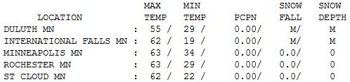

The Definition Of A Fine Spring Day. Could it have been any nicer yesterday? Blue sky, light breeze, low humidity. Highs ranged from 55 at Duluth to 62 St. Cloud, 63 Twin Cities to 65 at Redwood Falls. Poor Grand Marais, where spring comes only reluctantly, recorded a "high" of 44.

Paul's Conservation Minnesota Outlook for the Twin Cities and all of Minnesota
TODAY: Showers likely, soggy breeze. Cool and damp. Winds: SE 10-20. High: 57
FRIDAY NIGHT: Showers, risk of thunder. Low: 53
SATURDAY: Some mild sun. Late T-storms possible, some strong, possibly severe southern MN? Winds: S 10. High: 75
SATURDAY NIGHT: Showers and T-storms, locally heavy rain possible. Low: 57
SUNDAY: Mild and unsettled with more showers and T-storms, locally heavy rain. Winds: N 10. High: 68
MONDAY: Blustery and raw (huge drop in temperature) with rain/snow showers. No metro accumulation, but a few inches possible up north. Low: 35. High: 38
TUESDAY: Frost possible early. Intervals of cool sun. Tolerable again. Low: 32. High: 51
WEDNESDAY: Partly sunny, turning milder. Low: 40. High: 62
THURSDAY: Shower, then clearing. Low: 46. High: near 60
Global Weirding?
As if this spring couldn't get any more bizarre. We may go from low 70s Saturday to wet snow Monday; slush may accumulate on lawns and baffled robins over central Minnesota in less than 72 hours. I feel like I'm wandering through a weather exhibit at Ripley's Believe It Or Not. No, this isn't even close to being "normal".
I'm happy to see some yellow and red blobs on Doppler radar. Over half an inch of badly-needed rain may fall by Sunday. A 70 degree high Saturday may leave the atmosphere unstable enough for a few strong/severe T-storms, mainly far southern Minnesota. And then surface winds swing around to the northeast. A cool, showery Sunday is followed by a March-like slap of rain & snow showers Monday.
I will talk slowly and use small words: "some towns in central and northern Minnesota may pick up a few inches of slush Monday". Have a nice day!
Another frost/freeze Tuesday morning gives way to 60 later in the week. Long-range guidance still pulls more 60s, even a few 70s, back into town the last week of April. Something on the maps for everyone: drought, fire, 70, hail-producing thunderstorms late Saturday, rain, wet snow, frost/freeze. Did I leave anything out? Oh yeah....plague and pestilence. Happy I don't have to track those two bad omens, but if locust suddenly show up on the weather maps I'm out of here.

Photo credit above: "Attacks on climate science by former NASA staff should not be considered equal to the work of NASA climate scientists such as James Hansen, pictured. Photograph: Gareth Fuller/PA."


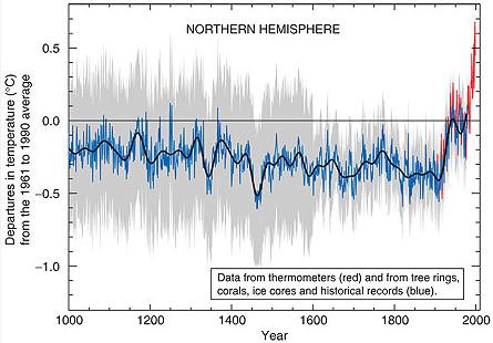
Summary: Hockey stick shape. Warmer Medieval Warm Period (MWP) followed by cooler Little Ice Age (LIA) and significantly warmer temperatures in the modern era.
Controversy: This is the plot that gets all of the attention. This is the plot that the National Research Council (NRC) investigated in 2006 at the request of Congress. The NRC supported the scientists and their conclusions."
* graph above courtesy of 2001 IPCC summary.
Study Links Raised Carbon Dioxide Levels To Oyster Die-Offs. The story from The New York Times; here's an excerpt: "Oyster hatcheries along the Washington and Oregon coastlines began experiencing calamitous die-offs beginning in 2006. Scientists suspected they were due to increased carbon dioxide levels in the air that were causing ocean acidification. That theory has now proved out, according to a study just published by the journal Limnology and Oceanography. Researchers began studying the oysters at Whiskey Creek Hatchery in Oregon in 2009 after the hatchery reported that production there had declined by as much as 80 percent in recent years. The scientists paid close attention to the seawater that had bathed the oysters."
No comments:
Post a Comment