TUESDAY: Patchy AM frost central MN and far outlying suburbs. Fading PM sun. High: 60. Winds: SW 5-10mph.
TUESDAY NIGHT: A chance of showers and thunderstorms. Low: 50. Winds: S 5-10mph
WEDNESDAY: Lingering shower or storm early. High: 63. Low: 40. Winds: W 5-15mph
THURSDAY: Scattered rain showers, mainly south. Rain showers could perhaps mix with a little light snow late. High: 51. Low: 35
FRIDAY: Wet start, slow clearing. Brisk! High: near 53. Low: 34
SATURDAY: Fading PM sun, late day shower possible north. High: 54. Low: 40
SUNDAY: A little more sun, lingering spotty shower early. High: 61. Low: 41
MONDAY: Sunny. Warmer south wind. High: 67. Low: 48
Heavy Weekend Rain
The Upper Midwest picked up some impressive precipitation totals, here is a look at the radar estimates from across the region thanks to the NWS
The upper midwest received multiple rounds of rain and some snow over the weekend. The rainfall was much needed to help combat the ongoing drought conditions across the region. Below is a summary of how much precipitation was received over this past weekend.
Below is the 72 hour (7AM Friday through 7AM Monday) accumulated precipiation estimate from radar.

As you can see, much of southern Minnesota and west central Wisconsni received 1.5 to 3.0 inches of precipitaton from Friday to Monday.
Here is a link to the Regional Max/Min Temp and Precipitation Table which shows the 24 hour precipitation totals as of this morning. You can select previous versions of the table to see 24 hour precipitation totals from previous days.
Not too often do we see tornadoes and shovelable snow within a 12 hour period across the state of Minnesota, talk about extremes! On Sunday evening, trained weather spotters reported tornadoes in Lyon and Mcleod counnties! On Monday morning, some folks across the Arrowhead of Minnesota woke up to nearly a foot of snow! In fact, there was so much snow that some schools closed for the day.


It's not all that uncommon to see tornadoes or snow in Minnesota and Wisconsin in the month of April. Minneapolis averages 2.2" of snow in April while International Falls see around 7". This week also turns out to be Severe Weather Awareness Week in Minnesota and Wisconsin. On average, Minnesota sees a little over 1 tornado in April. This month also holds the single deadliest tornado in Minnesota history when on April 14th, 1886 a tornado tore through St. Cloud/Sauk Rapids and claimed 72 lives.
A tug of war between seasons keeps the battle ground of two different air masses closer to home at this time of the year in greater frequency. The good news is that I don't see any severe weather for us in the near future, though, we should be able to get more much needed rain this week. Weather conditions will also improve this weekend.
Don't worry... it's not weird to see tornadoes/snow in Minnesota in April. Minneapolis averages 2.2" of snow, St. Cloud averages 3.0" Duluth and International Falls see 7"

Severe Weather Awareness Week Continues
For Minnesota and Wisconsin - see here for more information
Tuesday, April 17th - Severe Weather Watches and Warnings, and How to Receive Severe Weather Information
Wednesday, April 18th - Flash Floods
Thursday, April 19th - Tornado Safety Information
Friday, April 20th - Heat Waves
Thursday, April 19th - Tornado Safety Information
Friday, April 20th - Heat Waves
Tornado watch/warning drills will be held on Thursday, April 19th. A schedule for the tornado watch/warning drills appears at the bottom of the page.

Heavy NE Minnesota Snow
Thanks to Donna Schoeben for these pictures! Her dog, Bones, seemed to like the fresh snow Monday morning.


Snowfall Map

Snowfall Reports

April 24th Tornado
5 miles west of Marquette. Picture by Will Campbell

Waynoka, OK "Sisters" - By Tim Marshall
Tim Marshall caught these tornadoes on Saturday near Waynoka, OK

135 PRELIMINARY Tornado Reports
The Storm Prediction Center has the PRELIMINARY tornado count to 135 from Saturday's severe weather outbreak. Keep in mind, the ACTUAL tornado count will likely be much less.

Saturday's Severe Weather Outlook(s) by the SPC
Here's an evolution of the convective outlooks issued by the SPC for Saturday's outbreak, with preliminary storm reports overlaid on the final Day 1 outlook (bottom right).

Weather For Dummies by Josh Johnson
It's happened for years now - the national (and some local) media just can't seem to report weather-related stories without goofing something up. There are times where the goofs are minor, but many of the mistakes are substantial. It's even worse that this is happening at the national network level, where, in theory, the reporters and anchors should be "the best of the best."

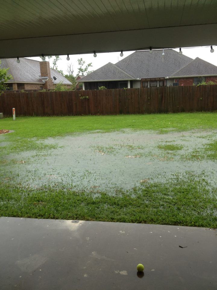
Heavy Texas Rain
Thanks to Cindy Morgan for this picture from Texas. At the time of this picture, she had nearly 8" of rain and as she put it... Lake Morgan developed in the backyard.
Flooding in Texas
Thanks to the National Weather Service out of Corpus Christi, TX for the picture below from Gregory, TX

Incredible Radar Rain Estimates
A cold front stalled across the Coastal Bend Monday. At the same time, an upper level disturbance is moving into the region. With the stalled cold front boundary, training of thunderstorms across the same areas allowing local pockets of 3 to 5 inches causing localized flooding. The most prolific rainfall that occurred Monday occurred east of highway 77 along the Coastal Bend, where 12 to 16 inches occurred in the Portland-Gregory region extending northeast just south of Bayside and west of Rockport. Another pocket of 8 to 10 inches has occurred Northeast of Refugio, and another 6 to 8 inches between Quintana and McFaddin. Remember when encountering a flooded roadway or overrunning creek, Turn Around, Don’t Drown. Some areas received 1 to 2 inches of rain per hour…mainly east of Highway 77.

Thanks for checking in and have a great rest of your week.
Don't forget to follow me on Twitter @TNelsonWNTV

No comments:
Post a Comment