59 F. average high for April 18.
50 F. high temperature on April 18, 2011.
.18" rain fell at KMSP Wednesday morning.
.37" rain predicted for the Twin Cities metro area this afternoon and evening (NAM model). Umbrellas recommended.
.12" rain forecast for Saturday at MSP (showery rains).
Sunday: sunnier, milder, drier day of the weekend (highs in the mid-60s)
3 F. low temperature reported at Grand Marais Tuesday morning, coldest in the Lower 48. There was still a little snow on the ground, and under clear skies with light winds what little heat there was quickly radiated into space.
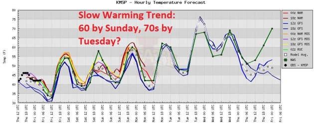
Gradual Warming Trend. You may need a light jacket today, but 60 should return by Sunday, a good shot of 70+ readings by Tuesday and Wednesday of next week. A few models are hinting at a light frost across central Minnesota Friday morning.
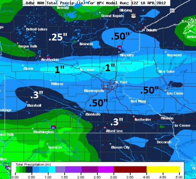
More Welcome Rain Today. The 00z NAM shows a thin stripe of 1" rains over central Minnesota, the heaviest rainfall amounts in a band from Morris to St. Cloud across the far northern suburbs.
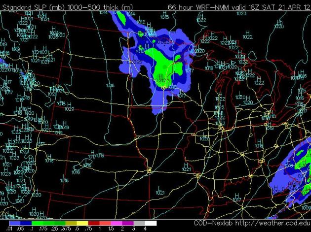
Saturday Clipper. The latest NAM model brings clouds and showers into Minnesota Saturday, the best chance of a few hours of rain over central and northern Minnesota, with highs stuck in the 50s. The good news: the atmosphere will be too cool and stable for anything severe.

“The climate has shifted to a new state capable of delivering rare & unprecedented weather events." - Weather Underground's Dr. Jeff Masters, in a Think Progress article below.
“Most people in the country are looking at everything that’s happened; it just seems to be one disaster after another after another,” said Anthony A. Leiserowitz of Yale University, one of the researchers who commissioned the new poll. “People are starting to connect the dots.” - excerpt from a New York Times article; details below.
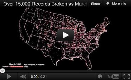
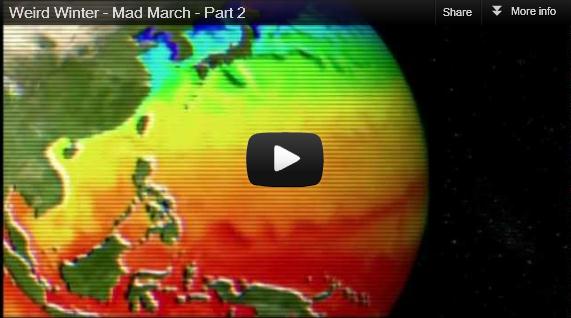
A March Like No Other. From an article at The Christian Science Monitor: "According to NOAA scientists at the National Climatic Data Center (http://www.ncdc.noaa.gov/sotc/), record and near-record breaking temperatures dominated the eastern two-thirds of the nation and contributed to the warmest March on record for the contiguous United States, a record that dates back to 1895. This animation shows the locations of each of the 7,755 daytime and 7,517 nighttime records (or tied records) in sequence over the 31 days in March."
1 in 3 Americans have been impacted by extreme weather, according to findings of a recent national poll.
4% increase in relative humidity, worldwide, in the last 30 years - meaning more moisture for floods and weather extremes.

"The fact that it's impossible to draw a straight line between climate change and the seemingly more turbulent weather doesn't mean we should act as if the two aren't linked. There's no doubt that warming raises at least the risk of extreme-weather events, something we're thinking about more in the early part of what is shaping up to be a brutally hot year in the U.S." - excerpt from an article about extreme weather and climate change from Time Magazine below.
"Americans, thus, correctly accept the idea global warming should make the weather warmer and precipitation events a bit more extreme. They may overreach in connecting individual weather events to climate change, but these connections are complex and it’s probably not reasonable to expect most people to unravel all of the intricacies." excerpt from meteorologist Jason Samenow in The Capital Weather Gang - details below.
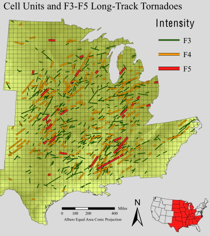
Map above courtesy of Michael Frates, University of Akron. More information here.
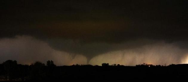
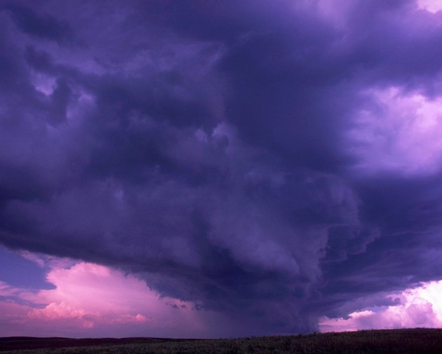
Photo credit above: "A tornado on the ground makes it way through the night near Salin, Kansas, during the third day of severe weather and multiple tornado sightings, April 14, 2012. A spate of tornadoes tore through parts of Oklahoma, Kansas, Nebraska and Iowa, churning through Wichita and other areas, causing widespread damage and killing two. (Gene Blevins/Reuters) PHOTO LINK."
Tornado Safety Information. From the Twin Cities office of the National Weather Service:
Tornado watches highlight the area where tornadoes are most likely to develop. Continue with your normal activities, but keep informed of the latest weather information and be ready to get to shelter in case tornadoes develop quickly.
In the Home...
Go to the basement if possible. Get under a table, work bench, or some other sturdy furniture to avoid falling debris. A stairwell is also a good place to hide during a tornado.
If You Cannot Get to a Basement...
Go to a small interior room on the lowest floor. Closets, bathrooms, and interior halls afford the best protection in most cases, or try to hide under a bed. Get under something sturdy or cover yourself with blankets. Stay away from windows.
In an Apartment, School or Office Building...
Move to the inner-most room on the lowest level or to a pre-designated shelter area. Stay away from windows. If in a hallway, crouch down and protect your head from flying debris. Avoid areas with glass and large roof expansions.
In a Mobile Home, Car, Truck or Other Vehicle...
Abandon these as quickly as possible. Seek a sturdy shelter or permanent structure. Remember that many deaths occur when people try to drive away in a vehicle, but get caught in the deadly winds. Avoid bridges since they act as wind tunnels.
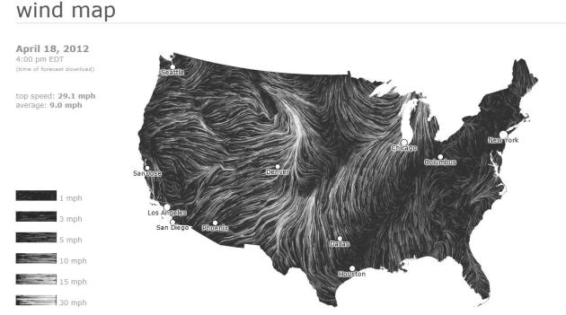
High-Resolution Winds Across The USA. Back by popular demand, this is actually a high-resolution short-term forecast of wind speed/direction, based on NOAA's NDFD - courtesy of hint.fm. You can click on the link to get this up on your browser - zoom into specific regions and a pop-up window gives you forecast wind direction/speed wherever you place your cursor. This is one of the best visualizations of weather information I've ever seen - anywhere.
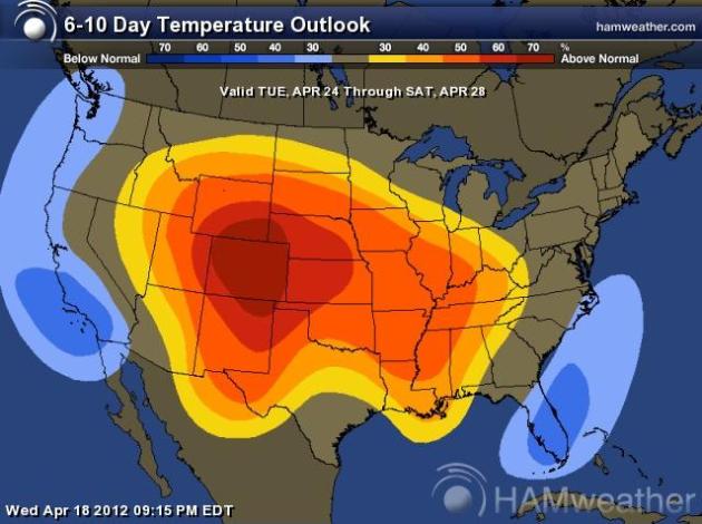
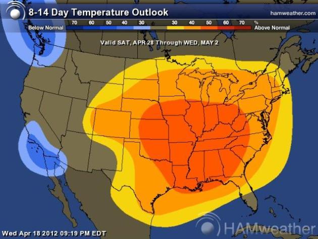
Light Jackets Give Way To Shorts Next Week. The CPC (Climate Prediction Center) 6-10 day temperature trend (upper left) and 8-14 day trend (upper right) shows a continued warm bias for much of America east of the Rockies. Not as dramatic as March, but some 70s are likely from Tuesday through Sunday of next week. Map courtesy of NOAA and Ham Weather.
• Make plans to secure your property. Permanent storm shutters offer the best protection for windows. A second option is to board up windows with about 5/8-inch-thick marine plywood, cut to fit and ready to install.
• Install straps of additional clips to securely fasten your roof to the frame structure. This will reduce roof damage.
• Be sure trees and shrubs around your home are well-trimmed.
• Clear loose and clogged rain gutters and down spouts.
• Determine how and where to secure your boat (if you have one).
• Consider building a safe room."
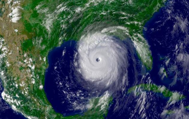
* Image of Hurricane Katrina (2005) above courtesy of NASA and NOAA.
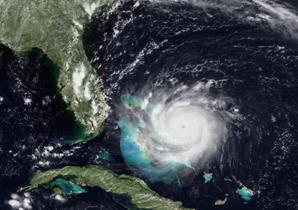
Photo credit above: "This image from the GOES-7 satellite shows Hurricane Andrew at its peak intensity on August 24, 1992 before making landfall near Homestead, FL." Source: NOAA.
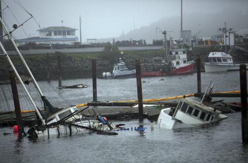
Photo credit above: "Sunken fishing boats in the harbor after tsunami swells from the earthquake in Japan last week stuck the area in heights of up to eight feet, in Crescent City, Calif., March 15, 2011. The city has long been known as one of the nation’s most susceptible inlets when it comes to tsunami, and this past week's tsunami has left damages believed to be in the tens of millions of dollars, shutting down one of Northern California’s most lucrative fishing operations. (Jim Wilson/The New York Times)."
"I need to know what the rainfall in Eden Prairie has been since November 1, 2011. It’s for a client of mine. I have checked everywhere I can think of and all the sites want money to give me that information. Is this something you can help me with or can you recommend a good website where I can find that information."
Thank you.
Gayle
Gayle Dungey
Caldwell Banker Burnet
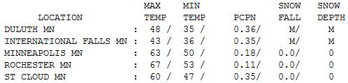

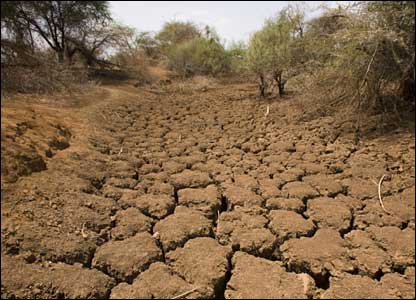
Putting A (Small) Dent In The Drought. Yes, we're still in a moderate to severe drought, but every little bit helps. Brainerd picked up just over .50" rain Wednesday; so did Grand Marais. The Twin Cities: .18" with .35" at St. Cloud. Highs ranged from 43 at International Falls to 67 at Rochester.

Paul's Conservation Minnesota Outlook for the Twin Cities and all of Minnesota:
TODAY: Cool, damp and showery. Winds: NE 10-20. High: near 50
THURSDAY NIGHT: Showers taper (few flurries over central MN late?) Low: 37
FRIDAY: Partly sunny, cool breeze - dry sky. High: 58
SATURDAY: Patchy clouds, a few showers likely. Winds: SE 10. Low: 39. High: 58
SUNDAY: Partly sunny - the nicer, sunnier, drier day of the weekend. Winds: NW 10-20. Low: 44. High: 62
MONDAY: Bright sun - beautiful. Take the day off. Low: 40. High: 66
TUESDAY: Fading sun, springy again. Low: 46. High: near 70
WEDNESDAY: Intervals of warm sun, slight chance of a T-shower. Low: 52. High: 73
* 70s, even a shot at 80 in the Twin Cities metro, the latter half of next week.
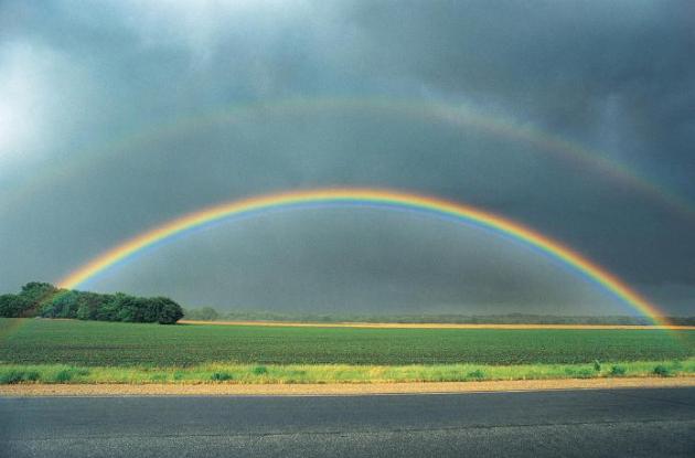
Welcome Puddles
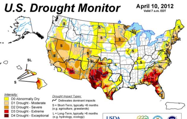
No more "risk of rain" or "threat of showers". So often we use a pejorative when describing expected weather; the assumption that (most) people dislike puddles, especially on a weekend - when more of us are at the mercy of the elements. In spite of recent rains 99 percent of Minnesota is still "abnormally dry"; NOAA's Drought Monitor shows nearly a quarter of the state in severe drought. Plants and crops have "first mortgage" on any rain - we need about 3-6 inches of water to get lake water levels back up to where they should be.
So I won't moan and groan about today's showers. We dry out a bit Friday, but a nearby frontal boundary, coupled with a nagging swirl of cold air aloft, will keep clouds and showers overhead Saturday - Sunday looks sunnier, drier and a bit milder. Monday looks stunning (naturally). We may hit 70 by next Tuesday - the first chance of severe T-storms not until next Thursday.
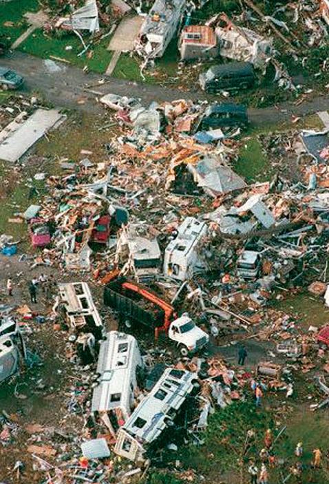
This is Severe Weather Awareness Week in Minnesota. Although I still think a dry bias may prevent us from seeing a rerun of 2010's craziness (145 tornadoes in Minnesota!) we all need to be prepared. That means a NOAA Weather Radio, smartphone apps and e-mail alerts.
The more sources of severe information - the better.
Climate Stories...
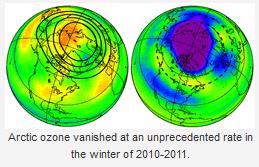
- Arctic Warming Favors Extreme, Prolonged Weather Events ‘Such As Drought, Flooding, Cold Spells And Heat Waves’
- Is Climate Change Bringing the Arctic to Europe?
- Hansen et al: “Extreme Heat Waves … in Texas and Oklahoma in 2011 and Moscow in 2010 Were ‘Caused’ by Global Warming”
Americans Connect Dots Between Extreme Weather And Climate Change. The Capital Weather Gang's Jason Samenow has an excellent post in The Washington Post; here's an excerpt: "Most Americans get it: global warming is intensifying heat waves and extreme precipitation to some degree. That’s the take away from a new public opinion survey from the Yale Project on Climate Change Communication and George Mason University Center for Climate Change Communication. The survey, which queried more than 1,000 adults across the country about global warming and extreme weather, discovered roughly two-thirds of Americans believe global warming is linked to several of the extreme weather events of 2011 and the recent mild winter. Predictably, this news has drawn the full spectrum of reactions." Photo from my book, "Restless Skies, The Ultimate Weather Book", courtesy of Sterling Publishing.
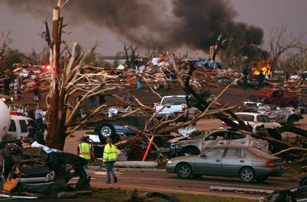
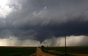
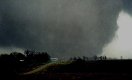
Photo credit above: "A tornado makes its way through farmlands near Rush Center, Kansas, on April 14, 2012. Over 100 tornadoes ripped through several Plains states in just 24 hours that weekend." Gene Blevins / Reuters.
- 82 percent of Americans report that they personally experienced one or more types of extreme weather or a natural disaster in the past year;
- 35 percent of all Americans report that they were personally harmed either a great deal or a moderate amount by one or more of these extreme weather events in the past year;
- Over the past several years, Americans say the weather in the U.S. has been getting worse – rather than better – by a margin of over 2 to 1 (52% vs. 22%)."

-- "Both the U.S. and Canada are developing technologies to better track increased shipping traffic in the Arctic.
-- Shell Oil is exploring for oil and natural gas in the Beaufort Sea, just north of Alaska, and Exxon Mobile has just signed a deal with the Russians to do the same thing in their Arctic waters.
-- In 2009, because “evidence indicates that the Earth’s climate is changing, and the most rapid changes are occurring in the Arctic,” the U.S. Navy created Task Force Climate Change to help naval leaders deal with the significant climatic changes in the Arctic.
-- The Pacific island nation of Kiribati is negotiating to buy land on the island of Fiji so it will have some place to move its 113,000 people before the Pacific Ocean inundates the entire nation (the first of thousands of islands so threatened)."
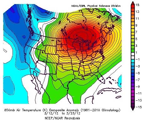
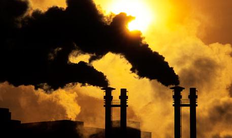
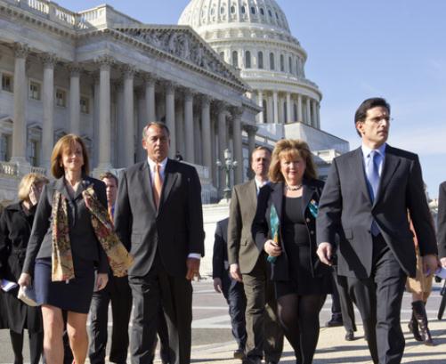
Photo credit above: J. Scott Applewhite/AP. "Congressional Republicans have a unique achievement, they are further from the political center than their predecessors of the past century."
No comments:
Post a Comment