By Todd Nelson
Ahh,
the lazy days of May continue today. Sure it's a bit cool, but we're
within a month of the Summer Solstice, so the sun is quite strong now.
If you can get out of the wind and soak up some sun, it actually feels
quite nice despite the cooler than average temperatures.
May
and June have quickly become my favorite months after the long
Minnesota winters. Being a recent home owner, I've come to find out how
relaxing it can be to goof and putz around in the yard or garden.May and June also tend to be the time when cool air retreats into Canada and warm air from the south, makes a return with thunderous outbreaks. There's nothing better, in my mind, than looking at big puffy cumulus clouds, billowing into thunderheads across a bright blue sky.
We'll be free of any significant storms for a while, but a quick moving system will sail south of us today and tomorrow with chilly showers in the southern part of the state.
It'll be a slow and gradual trend toward warming, but we'll get back to average by the weekend. A spike in temps and humidity values into our first week of June could bring in a few more thundery outbreaks.
Don't worry, temps over the weekend will warm too, but have a plan 'B' just in case a few big fat clouds decide to drift overhead Saturday evening or Sunday
____________________________________________________________________________________________
Todd's Conservation MN Outlook for the Twin Cities and all of Minnesota:WEDNESDAY: Fading sun, rain stays across the southern part of the state late. High: 63 Winds: NNE 5-15mph
WEDNESDAY NIGHT: Scattered rain showers continue, mainly south of the I-90 corridor in southern Minnesota. Low: 46
THURSDAY: Leftover clouds, showers possible far south. High: 64
FRIDAY: More sun and a little warmer. Low: 52. High: nearing 70
SATURDAY: Comfy June sunshine. Isolated thunderstorm possible overnight? Winds: turning S 10-15. Low: 53. High: 75
SUNDAY: Partly sunny and warmer with a chance of an afternoon/evening thunderstorm Low: 57. High: near 80
MONDAY: Summer-like again, few storms. Low: 62. High: 82
TUESDAY: Feels like June, PM storm?. Low: 62. High: 81
____________________________________________________________________________________________
Blog for Wednesday, May 30th, 2012
Happy
end of May everyone (first day of June is Friday), hope all is well!
Most folks are back to work and school now after the long holiday
weekend and the unofficial start to summer. I'm sure it's tough to get
back into the swing of things, so I'll start you off with this cool
picture that was shared by

More Pictures
Thanks
to Cathy Emmet Palmer for this picture out of Panama Beach, FL as
remnant clouds from Tropical Depression Beryl rolled through the area.
It certainly made for a beautiful sunset picture!

Intense Lightning
Thanks to Corey Hoffman for sharing this picture on Facebook who says: "This one was taken by my friend while on a chase of a severe warned storm near Ohio, IL in Bureau County."

Memorial Day Hail Pictures out of MN
Thanks
to Anna Kate Louks for this picture out of Sartell, MN. Hail fell and
neared the severe criteria of 1" diameter, which is the size of a
quarter. Everything else is what I call 'small change hail' or
non-severe.

Thanks
to Chuck Boos out of St. Joseph, MN for the picture below. These
stones are clearly severe worthy as they are 1" (quarter-size) or
larger.

Thanks to Melissa Woods for this picture, also out of St. Joseph, MN. This too is severe worthy

I
doctored it up get a more accurate depiction of the size. According to
my dorky calculation, this stone may have been around 3.5" wide!

Extended Temperature Forecast
Sure
it's a bit cool now, but warm and more humid air will make a return by
late weekend/early next week. Extended model runs show a slow and
gradual warming trend through the rest of the week with 80s possible by
Sunday and/or Monday!

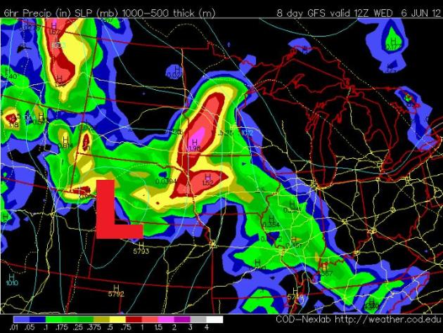
More Significant Thunder Returns?
I know
this is a ways out, but extended model runs are suggesting a better
chance of more widespread thunder as we transition into early next week.
It makes sense that as some of the heat and humidity returns, so does
the chance of thunderstorms... stay tuned! The image below suggests a
thundery Tuesday night NEXT WEEK.
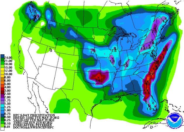
5 Day Precipitation Forecast
The
good news is that we'll have a chance to dry out for a while. Yes,
there is spotty rain in the forecast, but nothing quite as significant
as what we've seen over the past couple of weeks. The HPC 5 day
precipitation forecast shows a heavier blog of rain sailing south of
'most' of Minnesota Wednesday/Thursday. Also note the heavier streak of
precipitation across the Southeast into the Mid-Atlantic region...
That's Beryl or our 2nd named storm of the Atlantic Hurricane Basin. Get
this, it's not even the official beginning yet! The official beginning
is June 1st.
Beryl Continues
The
radar loop from early Tuesday showed bands of showers and
thunderstorms still rotating around the raggedy center of circulation
near southeastern Georgia.

Satellite Picture of Beryl From Tuesday

Beryl Track
The
interesting thing about Beryl is that the forecast has it becoming a
Tropical Storm again has it moves over open water by mid-week. The other
thing to note is the close proximity to the coastal communities of the
Carolinas. I'm concerned that wind damage may start to creep back into
the picture in these areas, especially is the ground is saturated with
heavy rains from Beryl. Trees could be toppled a little more easily if
both winds increase and heavy rain continues to moisten the ground.
Beach goers along the East Coast and especially in the Carolinas should
be very weary of rip current potential!

Rip Current Safety
"Rip
currents are strong narrow currents moving away from shore. The
strongest rip currents can attain speeds reaching 8 feet per second;
this is faster than an Olympic swimmer can sprint! On average, more
people die every year from rip currents than from shark attacks.
According to the United States Lifesaving Association, 80 percent of
surf beach rescues are attributed to rip currents, and more than 100
people die annually from drowning in rip currents."

Did You Know?
Did you know that (on average) rip currents kill more people annually than tornadoes?
Image Below Courtesy:

Louisville, KY Flooding
Thanks
to Laura Yancy for the picture below from near the University of
Louisville in Kentucky. Within a matter of hours, several inches of rain
inundated downtown Louisville. there were several reports of flooded
streets and stalled cars.

Severe Threat on Tuesday was a MODERATE
The
Storm Prediction Center had issued a MODERATE RISK of severe weather
across parts of the Northeast where hail and high winds were the
primary threat with isolated tornadoes possible. There was also a threat
of isolated tornadoes across parts of the Central and Southern Plains.

Severe Threat Wednesday
Wednesday
could be an interesting day with a MODERATE RISK of severe weather
being issued across the Central and Southern Plains. Tornadoes could be
an issued here again, so have those severe weather radios handy!

As High as a Cumulonimbus
Thanks
to Walt Kruhoeffer for this picture who took a flight to Baltimore
over the weekend and saw this towering cumulonimbus cloud in the
distance. Note how the thunderstorm seems to flatten at the top... this
is where the thunderstorm has reached the tropopause or the highest
point in the troposphere. The troposphere happens to be the layer in
the atmosphere where all the weather here on earth occurs in.

Atmosphere
These
are the different layers of the atmosphere, note the thunderstorm icon
in the troposphere. Also note how the cruising altitude of the jet is
located around the top of the thunderstorm at the tropopause. The
graphic below is very reminiscent of picture above.
Image Courtesy: http://www.windows2universe.org/earth/Atmosphere/mesosphere.html

The
reason for thunderstorms flattening out at the top is because as air
parcels encounter the tropopause and the stratosphere where the air
becomes more stable as temperatures begin warming with height. Air
parcel here stop rising freely and become 'capped'. The yellow line
below mimics the temperature profile within each layer of the
atmosphere.

_________________________________________________________________________________________
Questions:
Paul,
Took
these yesterday on the way back from Saganaga Lake. First one is of
the Temperance River. The others are at Gooseberry Falls. Was hiking
at Temperance last month and it was nothing like this. Last time I was
at Gooseberry was in March and I was ice climbing. What a
difference!!
Lightning question:
We
were camped right by the border on Sag Lake Fri-Mon. Sunday night we
had a few bands of T-storms. Nothing very severe but the lightning was
amazing. We were inside the tent so I couldn't see bolts but there
had to have been 50-100 flashes per minute but rarely was there any
thunder. That might be something I'd associate with heat lightning but
it never got above 55 degrees up there (if that). Any idea what it
was? Also, any good references that explain when the danger is highest
for CG lightning with a thunderstorm?
Thanks!
Steve
Thanks
for the amazing pictures below Steve, they're amazing! I lived in
Duluth for 4 years before moving back to the Twin Cities about 3 years
ago. My wife and I hiked the North Shore often at different times of the
year. It was always neat to see the river swollen (mainly in the spring
during the snow melt), but I've never seen it like this after such
heavy rains. I bet it was vivaciously loud, yea?
Now
for your question regarding the 'heat lightning' - this is an
interesting term because like you said, it never got above 55F while you
were observing the lightning. Lightning always creates thunder, but
either: a.) The lightning bolts occurred too far away from your
location, so even the subtle noises of rain or wind drowned out the
thunder making it harder for you to hear the thunder b.) the temperature
profile of the atmosphere near you helped to refract the noise away
from your specific location.
Did
you know that the average number of lightning fatalities across the
nation is 54? There have already been 3 lightning fatalities this year
and in 2011 there were 26 fatalities. The last MN lightning fatalities were in 2009; a 14 year old girl was playing in the rain at her home in Stillwater and
a 42 year old man was at home in St. Cloud doing yard work. The
National Weather Service has coined a term "When thunder roars, go
indoors". If you hear thunder, you are within striking
distance! Lightning can strike up to 10 miles away. Ever hear of the
phrase "Bolt from the blue"? It could be sunny over you, but a nearby
thunderstorm could strike while you're least expecting it. Remember the
30/30 rule. It you can see lightning and hear thunder within 30 seconds
(thunder travels at the speed of sound, so 5 seconds = 1 mile away; 30
seconds = 6 miles away) you are within striking
distance, seek shelter immediately. Then, wait 30 minutes after the last
rumble of thunder to head back outside, this simple rule of thumb with
improve your chances of surviving a potentially unexpected and fatal
lightning strike!
Temperance River

Gooseberry Falls

Thanks for checking in, have a great rest of your week!
Don't forget to follow me on Twitter @TNelsonWNTV

No comments:
Post a Comment