Paul Douglas
Science optional
When people talk about the theory of climate change I politely remind them that a warmer, wetter atmosphere is already having consequences: fickle winters, fewer subzero nights, more downpours and hailstorms. We've gone from theory to reality. So what? "A warmer Minnesota is a good thing Paul. Don't get your undies in a bunch!"
I speak out because I'm in touch with the world's leading climate scientists. They're scared.
Imagine 98% of cardiologists give you the same diagnosis, but 2 guys suggest you lower your blood pressure using magnets and duct tape. Crazy, huh?
But those 2 pseudo-scientists represent a trillion dollar industry. They confuse the public, keep doubt alive, falsely accuse the other 98%.
Sounds like the tobacco "debate" of the 70s; only it's 100 times worse, with serious implications for the planet - and our grandkids.
This is about science, justice, and doing the right thing, not just for us, but future generations. That's why I speak out.
Monsoon season is over, for now. A cooler, drier week is shaping up - comfortable 60s into Friday. A weekend warm-up sparks a few T-showers, but no flash floods this time.
9.15" in May? Yes, the drought is over.
____________________________________________________________________________________________
Todd's Conservation MN Outlook for the Twin Cities and all of Minnesota:TUESDAY: Sunny start, PM clouds with a spotty shower or two north. Breezy and cooler. High: 63 Winds: W 15-30mph.
TUESDAY NIGHT: Winds taper and skies clear a bit. Low: 44
THURSDAY: Leftover clouds, showers possible far south. Low: 48. High: 64
FRIDAY: More sun and a little warmer. Low: 50. High: near 70
SATURDAY: Sun fades with a stray late day storm. Winds: S 10-15. Low: 53. High: 74
SUNDAY: Partly sunny and warmer with a chance of an afternoon/evening thunderstorm Low: 58. High: near 80
MONDAY: Summer-like again, few storms. Low: 62. High: 84
____________________________________________________________________________________________
Blog for Tuesday, May 28th, 2012
Hope you had a wonderful Memorial Day weekend and thank you to everyone who has served our country past, present and future!

We remember those who fought for our freedom! What ever you did this weekend, remember why this weekend is special.
I
was able to take a trip up north to my aunt and uncle's cabin (yearly
tradition) and hooked up with the biggest walleye of my life... 9
pounder!! That's my little guy, Crosby, who will be 3 this summer, he
couldn't believe how big the fish was either.

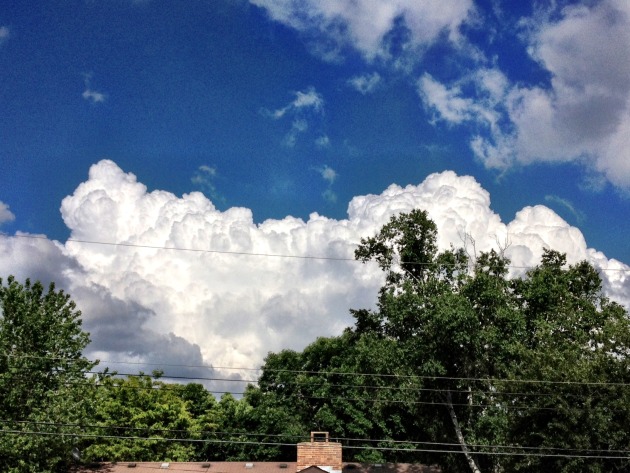
Puffy Cloud Alert
Monday
afternoon was great if you're an amature cloud watcher. Tower cumuls
clouds gave way to more robust and severe storms across parts of central
and northeastern Minnesota. In fact, there were several hail reports as
the line of storms slide into northwestern Wisconsin.
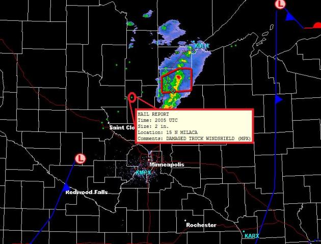
Monday's Strong Storms Drifted North of the Twin Cities
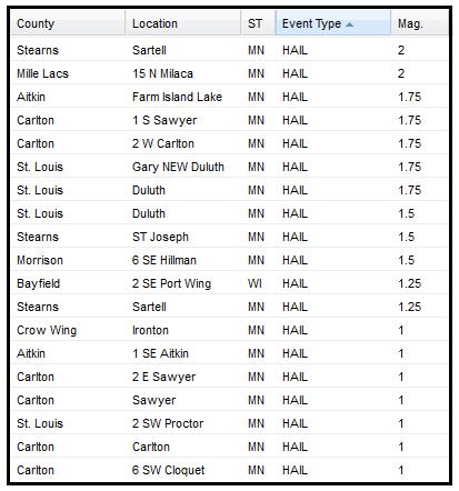
Other Hail Reports From Monday Afternoon
Tropical Depression Beryl
This was the view from space earlier Monday, note the nice circular shape to Beryl as she works across northern Florida.
Beryl became the first tropical cyclone to make landfall in Florida in over a century

Radar of Beryl Earlier Monday

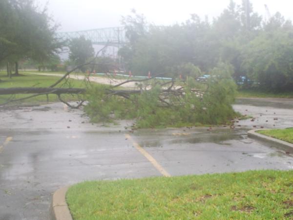
Damage in Jacksonville, FL
Winds
were much stronger Sunday night into early Monday as Beryl made
landfall. There were reports of trees and power lines down with several
thousand customers without power.
Beryl Track
The
8AM update from the National Hurricane Center had Beryl becoming a
Tropical Depression as he churns over Florida and Georgia. Winds are
necessarily going to be the main threat... heavy rain will be!
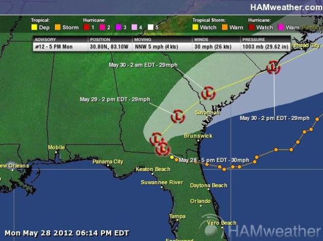
Flooding Concerns with Beryl
The
National Weather Service has issued flooding headlines for rainfall
amounts that could be 4" to 8" with locally heavier amounts.

Rainfall Forecast
This
is the rainfall forecast through 8AM Thursday. Note that the heaviest
precipitation is expected to be a little closer to the coast.

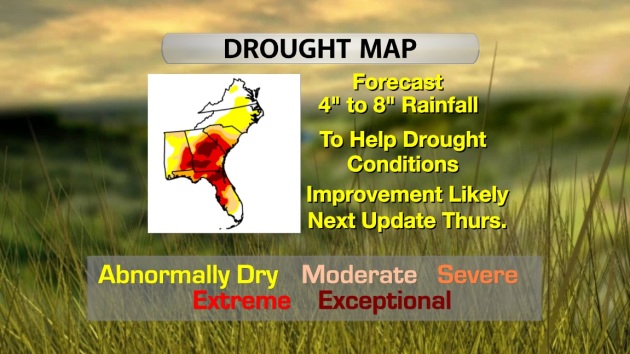
Drought Improvement Likely
These
are the types of tropical systems that we like! Minimal damage with
copious amount of tropical moisture, especially when it's moving into
drought stricken areas like that of the Southeast. The update from last
week had nearly 78% of the area abnormally dry with around 9% of that
considered in an EXCEPTIONAL DROUGHT. I'm sure we'll see some
improvement in that when the new update comes out this Thursday. I don't
think this will be a drought buster, but it'll certainly be a drought
denter!
Local Weather Radar Gets An Upgrade, Just In Time For Hurricane Season.
Here's an interesting article from myrtlebeachonline.com: "MYRTLE
BEACH -- Just in time for the 2012 Atlantic hurricane season,
forecasters with the National Weather Service in Wilmington, N.C., are
getting a boost in technology to help them better identify and predict
how much rain and hail is falling in a specific area during a storm. The
upgrade is taking place at all 160 radar stations in the U.S. and at
five overseas locations. It means forecasters will go from monitoring
single polarization radars to dual polarization radars, which gives them
the ability to see a second dimension and determine, for example,
where hail is falling and how big it is, said Steven Pfaff, a warning
coordination meteorologist in Wilmington. “This is the first big
modification. This is the next step in radar technology,” Pfaff said
holding two softballs – one with a single blue piece of tape and the
other with an X on it. Single polarization “gets us into the ballpark,
whereas the dual polarization will get us into the infield.” Image: UCAR.

Record Heat Memorial Weekend
Look
at this big bubble of heat that has setup across the eastern half of
the nation on Sunday. Record high temperatures will be likely again
today as this heat shifts to the east just a bit.

There
were nearly 300 record high temps recorded over the weekend. One of
the more notable locations was Chicago... They made it to 97° on
Sunday!

Severe Threat Today
On
the outer edge of this heat and humidity, showers and thunderstorms
broke out, some of which were severe. There were a little more than 200
reports of severe weather on Sunday.

As
the bubble of extreme heat shifts east, so will the severe weather
threat. Today hail, high winds and an isolated tornado threat will be
possible from the Great Lakes to the middle Mississippi Valley along the
cooler push of air. Interestingly, areas in the Southeast associated
with Beryl aren't in a specific severe threat, but there certainly could
be some stronger bursts of weather with any storm that develops
through the day, especially across northern Florida, southern Georgia
and South Carolina.
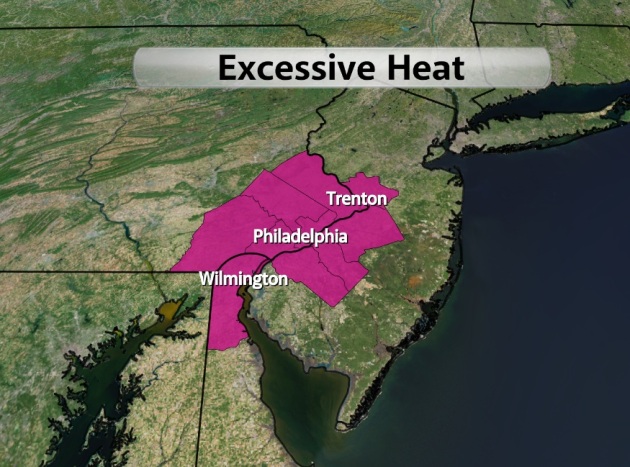
Excessive Heat Shifts East
The
National Weather Service has an Excessive Heat Warning in place for
counties shaded in pink for Tuesday where heat Index values could bump
up into the low 90s... Yikes! Summer is here!
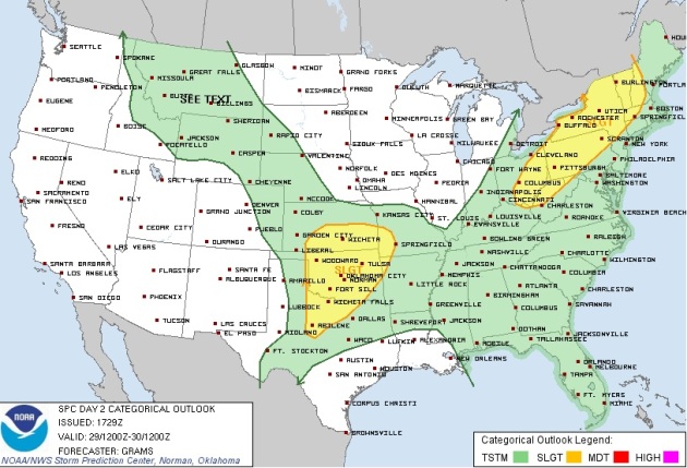
Severe Weather Threat Tuesday
Cooler
air is moving in and on the leading edge of this will be thunderstorm
activity. Some of the storms Tuesday afternoon/evening could bring hail
and high winds into the picture. This probably isn't what people what to
hear, but behing the front it'll bring a nice relief. Cooler, drier
weather is on the way and it'll stick around through the end of the week
for many in the Northeast.
Memorial Weekend Storm Recap
Below are some of the images from Sunday's storms that rolled through parts of the nation.
From NWS Wichita, KS Tornado in Russell KS. Picture by Jill Seguine- Click here:

From the NWS Pittsburgh, PA office: half dollar size hail that fell in the Rilton area of Westmoreland County Sunday evening around 630pm. Click Here

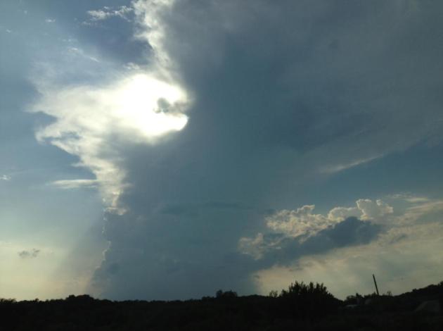
Stormy Sunday in Minnesota
This
was the scene from central Minnesota on Sunday afternoon/evening as
thunderstorms started popping. Interestingly, note how the thunderstorm
is tilting to the right as it gets taller. This is an indication of
'shear' in the atmosphere. Shear comes in 2 different flavors; Speed and
Directional. In this case you can see Speed Shear at work as stronger
upper level winds push the top of the developing storm to the right.
This would promote longer lived storm cells as the storm creates
separate updrafts and downdrafts. Watch out if you have both speed shear
and direction shear as thunderstorms not only would be longer lived,
but potentially rotating and producing tornadoes.
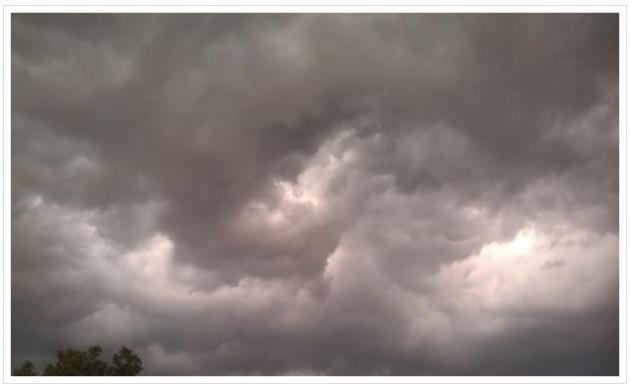
A Turbulent Sky.
Thanks
to Broadcast Weather meteorologist Miranda Hilger for sending in this
photo of an ominous, swirling sky drifting over Excelsior Sunday
evening.
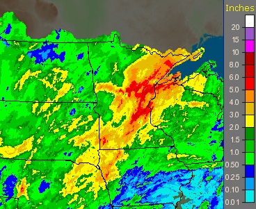
Heavy Rain Across Minnesota
Below is
the 14 day depiction of radar rain estimates. Note the deep reds from
southwest Minnesota to the northeastern part of the state. This is
indictating radar estimates of 5" to 8" across the area!
Northland Rivers Reaching Levels Not Seen in Several Years
"Continued heavy rain is causing some Northland rivers to rise to levels not seen in a decade or more.
The National Weather Service has dropped the flood warning for the St. Louis River at Scanlon. Flood stage is 10.5 feet, and the river was at 9.98 feet Monday morning. It is forecast to crest at about 10 feet early Tuesday - down from an earlier forecast crest of more than 11 feet. The river is running at its highest level in more than four years."
See the full story HERE from the Duluth News Tribune
Image Courtesy: Clint Austin & Duluth News Tribune

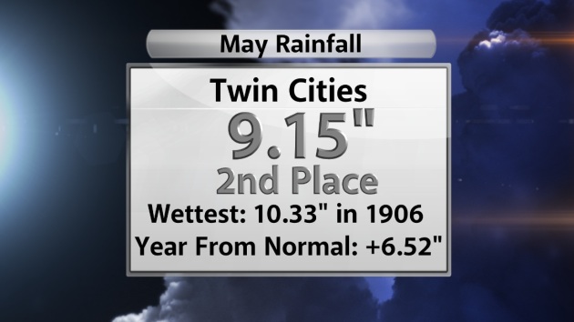
2nd Wettest May in Recorded History @ MSP
How about this... we've had so much rain this month that we're now sitting at the 2nd wettest May!
The National Weather Service has dropped the flood warning for the St. Louis River at Scanlon. Flood stage is 10.5 feet, and the river was at 9.98 feet Monday morning. It is forecast to crest at about 10 feet early Tuesday - down from an earlier forecast crest of more than 11 feet. The river is running at its highest level in more than four years."
See the full story HERE from the Duluth News Tribune
Image Courtesy: Clint Austin & Duluth News Tribune
2nd Wettest May in Recorded History @ MSP
How about this... we've had so much rain this month that we're now sitting at the 2nd wettest May!
Thanks for checking in and have a great rest of your week.
Don't forget to check me out on Twitter @TNelsonWNTV

No comments:
Post a Comment