72 F. average high for May 25.
64 F. high on May 25, 2011
1.06" of rain predicted by Monday morning. Heaviest rain likely Sunday night.
Severe threat Saturday and Sunday. SPC details below.
Low 90s likely Sunday: hottest, most uncomfortable day of the holiday weekend (dew points reach 72 F).
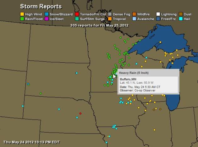
8.18" rainfall since May 1 in the Twin Cities.
2.71" average May rainfall as of May 25.
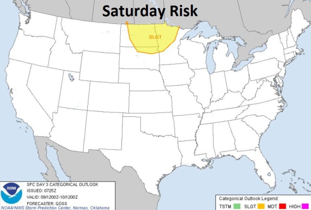

Saturday Severe Risk Sunday Severe Risk
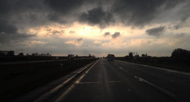
Weekend Severe Threat. A strong surge of hot, steamy air will spark waves of strong to severe thunderstorms today; an eastbound cool front may spark a few severe storms late Sunday into Sunday night across the Plains and Upper Midwest. Maps courtesy of SPC.

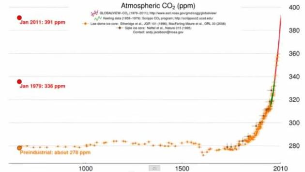
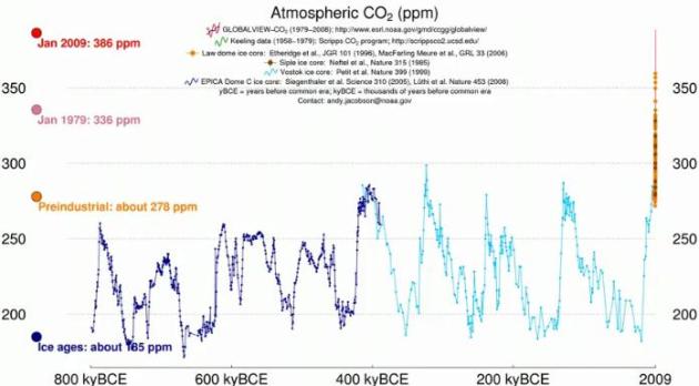
"For decades, solar activity has been trending downwards, even as temperatures have continued to rise. It's not that the researchers are being induced or compelled to some sort of biased interpretation of the data. Reality just happens to have a bias." - from an article about money and climate science at Ars Technica below.

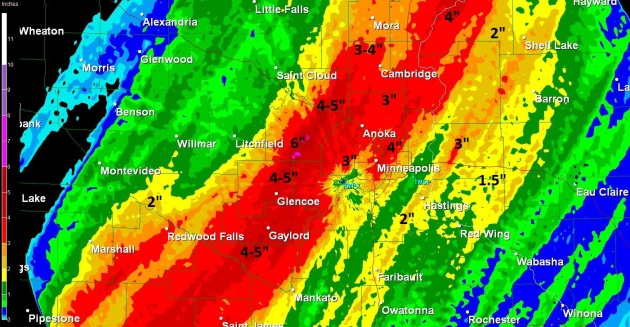
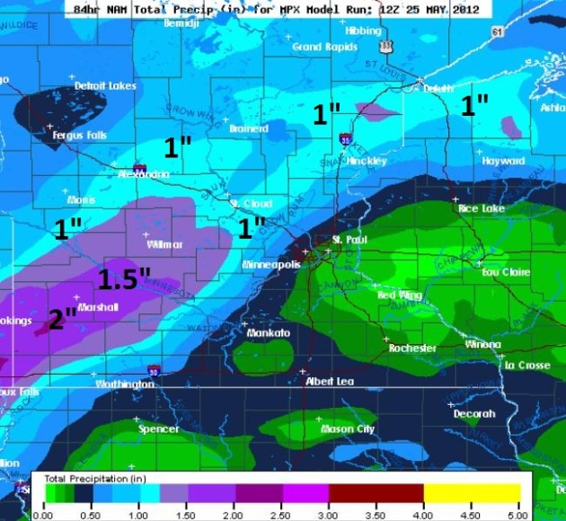
Additional Weekend Rainfall. The heaviest rains are forecast to fall just west of MSP over the next 84 hours - the latest NAM model printing out some 1.5 to 2" amounts near Marshall, over 1" from Brainerd and Alexandria into the far western suburbs of the Twin Cities, considerably less east of St. Paul.
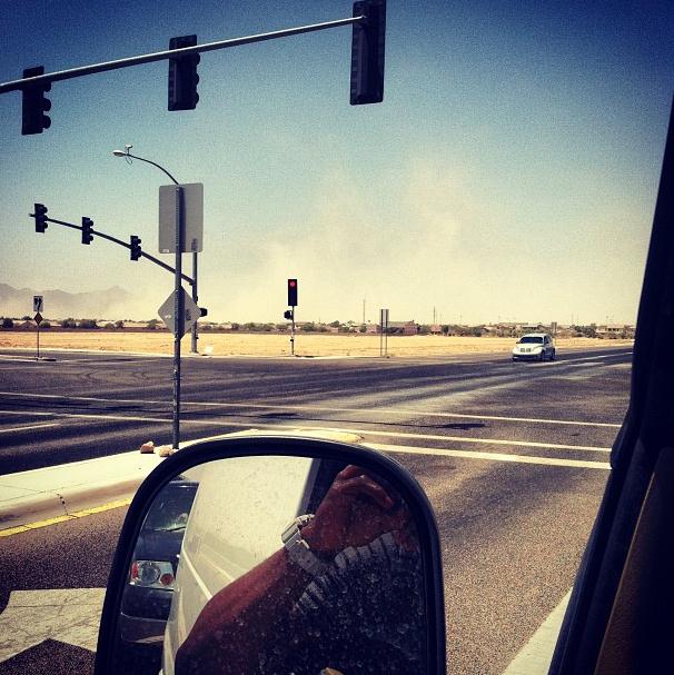
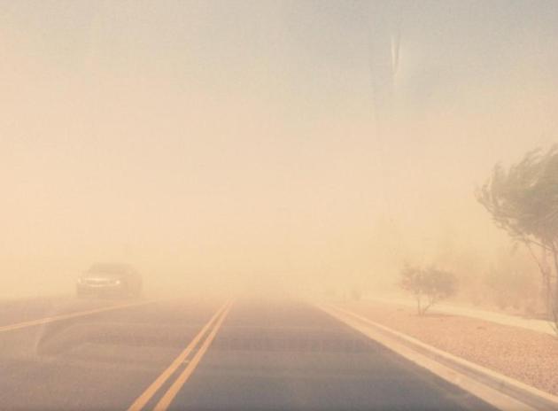
Sand Storm! Thanks to Wayne Angelo and Instagram, for capturing a massive sandstorm heading for the Phoenix area Friday.
El Nino May Lessen Hurricane Risk. Right now we're in an ENSO-neutral situation (no El Nino or La Nina); ocean water temperatures in the Pacific pretty close to normal for late May. Some oceanographers are predicting a mild El Nino warming by the end of 2012, which correlates with stronger winds over the tropics, winds that can shred tropical depressions and prevent them from maturing into hurricanes. But El Nino may come too late for the 2012 hurricane season. Here's an excerpt from an msnbc.com story: "To say our weather in many parts of the country has not been normal of late. In fact, far from it when you consider the historic and severe hurricanes and tornadoes we have witnessed to the freak events like the halloween blizzard in the east to a lack of winter for millions of americans this past season. It's against that backdrop that today's official government hurricane forecast comes out just as America geared up for the traditional start of the summer kickoff weekend, and it's where we begin our reporting tonight with NBC's tom costello. Get ready for the ferocious power of mother nature . The official start of hurricane season is still a week away, but it's already been an active two weeks. tropical storm Alberto has come and gone as hurricane Bud churned off new mexico. now a category two storm. Today from NOAA, a prediction for a near normal hurricane season between june 1st and november 30th . That means 9 to 15 tropical storms with 4 to 8 strengthens into hurricanes. and one to three of those becoming major hurricanes , category 3 or greater. the big wild card , the warmer effect from EL Nino in the Pacific."
- "Locate and agree on a safe room. Plan to find the lowest place in the house, without windows. Usually this is the basement or an interior closet or storeroom. Meet as a family and agree to the plan to meet there in case of emergency. Be sure that each family member has a plan for shelter away from home in case of a storm that doesn’t allow everyone to get home.
- Supplies. Be sure to keep supplies on hand in or near the safe room. These should include: water, a water purification kit, non-perishable snacks/food, blankets and pillows, clothing, first aid, medical equipment for special-needs family members, pre-moistened towelettes, hand sanitizer, zip-lock plastic bags, disposable eating ware, duct tape, necessary toiletries, flashlights with fresh batteries, radio, cell phone with charged batteries, entertainment items such as books, or games, pet care items. If you have a baby or toddler you will need appropriate supplies: diapers, baby food, formula, toys, etc. You may want a battery-operated laptop with a cellular modem to be able to connect with email and Internet.
- Evacuation plan. Have a plan if you will be required to evacuate due to incoming weather. Hurricanes and floods approach more slowly giving people time to escape."

Not Forgetting Why We Celebrate Memorial Day. Thanks to WeatherNation TV meteorologist Aaron Shaffer for snapping this photo in Boston, showing thousands of American flags on Bunker Hill.

* more race information for the Indianapolis 500, which kicks off noon on Sunday, here.


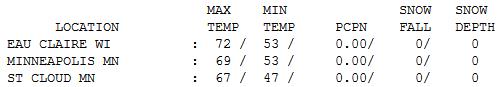

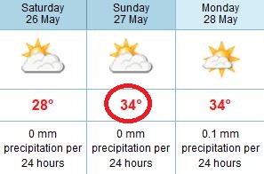
"Comfortable Front." Upper 60s felt pretty good yesterday, highs ranging from 62 at Alexandria to 67 St. Cloud, 69 in the Twin Cities and 72 at Eau Claire. By Sunday temperatures will be 25 degrees warmer across much of Minnesota.

Paul's Conservation Minnesota Outlook for the Twin Cities and all of Minnesota:
TODAY: Unsettled with Showers & T-storms, a few may turn severe. Winds: E 10-20. High: 78
SATURDAY NIGHT: Muggy with T-storms likely, some packing locally heavy rain. Low: 68
SUNDAY: Tropical sun - best beach/lake day. Dew points point 70, making it feel like upper 90s. Winds: S 20. High: 93
SUNDAY NIGHT: T-storms likely, some severe. Nearly 1" of rain may fall. Low: 64
MEMORIAL DAY: Damp start, then clearing, less humid. Winds: SW 10-20. High: 82
TUESDAY: Increasing clouds, turning cooler. Low: 53. High: 68
WEDNESDAY: Some sun, quite comfortable. Low: 49. High: 67
THURSDAY: Storm stays south. Cool sun. Low: 50. High: 71
FRIDAY: Fading sun, warming up. Low: 54. High: 76

Holiday Weather Angst
My wife is driving me nuts. That hardly
qualifies as breaking news, but let me explain. We are hosting a
graduation party Tuesday, so every hour, on the hour, I get a call,
text, e-mail (or earful) - demanding an update on the weather. "If it
rains on our son's big day I'm going to flatten you with a Doppler!" she
threatened. "Honey, I'm the messenger, I have NOTHING to do with the
weather" I said, but to no avail.
I get
pleading notes from brides: "Hi Paul, I'm having an outdoor wedding, in
June, the wettest, most severe month of the year!" Hooray. Rent the
tent. Otherwise you're a big target for Mother Nature, who has a demented sense of humor.
The
holiday weekend won't be a total bust. Hot, tropical air surging
northward sparks severe T-storms today. By tonight it will be steamy,
with dew points above 70. We break out into the "warm sector" of the
storm tomorrow, highs may reach the sweaty mid-90s. Sunday should be the
best day to loiter at the lake, beach or pool. A cooler, drier front arrives Memorial Day. A wet start Monday should give way to PM sun, highs in the low 80s, with a welcome dip in humidity.
Something for everyone: thunder, hot sun, sauna-like humidity. Have fun!
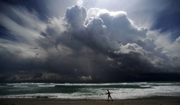
* photo above courtesy of Yahoo.
Climate Stories...

Climate Armageddon: How The World's Weather Could Quickly Run Amok (Excerpt). Here's a troubling excerpt of a story at Scientific American: "The eminent British scientist James Lovelock, back in the 1970s, formulated his theory of Gaia, which held that the Earth was a kind of super organism. It had a self-regulating quality that would keep everything within that narrow band that made life possible. If things got too warm or too cold—if sunlight varied, or volcanoes caused a fall in temperatures, and so forth—Gaia would eventually compensate. This was a comforting notion. It was also wrong, as Lovelock himself later concluded. "I have to tell you, as members of the Earth's family and an intimate part of it, that you and especially civilization are in grave danger," he wrote in the Independent in 2006. The world has warmed since those heady days of Gaia, and scientists have grown gloomier in their assessment of the state of the world's climate. NASA climate scientist James Hanson has warned of a "Venus effect," in which runaway warming turns Earth into an uninhabitable desert, with a surface temperature high enough to melt lead, sometime in the next few centuries."
Killer Heat Waves: Heat-Related U.S. Deaths Could Increase By 150,000 By Century's End Due To Climate Change. Here's a clip from an NRDC article: "NRDC released a report today projecting that more than 150,000 additional Americans could die by the end of this century due to excessive heat caused by climate change. This startling conclusion is based on peer-reviewed scientific papers published recently by Dr. Larry Kalkstein and colleagues. This is the kind of study that should make headlines around the country but is generally ignored when published only in scholarly journals. So NRDC is presenting the information in a more accessible manner, adding calculations of the cumulative additional death toll attributable to projected global warming by mid-century and century’s end (the report, including these additional calculations, was reviewed by Dr. Kalkstein to ensure that we have presented the information accurately)."

Climate Change Allows Once-Rare British Butterfly To Thrive. The story from The Christian Science Monitor: "Warming in Great Britain appears to have given a little brown and orange butterfly an edge. The brown argus butterfly has spread about 49 miles (79 kilometers) northward on the island over 20 years, observations indicate. Although it's well known that climate change can prompt plants and animals to shift the ranges in which they live, the brown argus (Aricia agestis) has widened its living quarters with unusual speed, according to an analysis of decades of data collected by British volunteers. The butterfly's secret? A new host plant to feed its larvae."
Photo credit above: "Warming has allowed the brown argus butterfly to rapidly expand its range in England and Wales." Louise Mair.
Climate Change And The Media. Here's a post from redding.com: "According to Yahoo News, the Casey Anthony trial was the number one issue in 2011. Global climate change did not make the top ten, although, according to the National Oceanic and Atmospheric Administration, the U.S. experienced "14 weather and climate disasters in 2011, each (of which) caused $1 billion or more in damages -- and most regrettably, loss of human lives and property." When Rasmussen recently conducted a national telephone survey of what Americans considered the most important issues, global climate change was not mentioned. Number one on the list was the economy with 82 percent of Americans reporting this as being very important. Their tenth concern was Afghanistan with 27 percent of Americans citing the war as very important."
Countries Doing Too Little On Warming: Research. Reuters has the details: "Greenhouse gas emissions in 2020 could rise to nine billion metric tons (9.92 billion tons) above what is needed to limit global warming as some countries look set to miss their emissions cut targets, a report by three climate research groups said on Wednesday. Countries have agreed that deep emissions cuts are needed to limit an increase in global average temperature to less than 2 degrees Celsius this century above pre-industrial levels, a threshold that scientists say is the minimum required to limit devastating effects like crop failure and melting glaciers. They believe the 2 degree limit is only possible if emissions levels are kept to around 44 billion metric tons of carbon dioxide equivalent in 2020."

No comments:
Post a Comment