Paul Douglas
Weather whiplash
Weather whiplash
"Keep your expectations low and you'll
never be disappointed." When was the last time someone blamed you for
ruining their holiday? Meteorologists live in mortal fear of summer
holiday weekends, and for good reason. If you "bust" - people remember
for a long, long time. I'm still reminded of a July 4th (1976!) forecast that went south. I predicted sprinkles - we got a flood. Note to self: time to audition for a new career.
Just a month ago we were fretting about
drought; now we've made a U-turn into flood territory. Two thoughts: the
number of 3 inch downpours has doubled since 1961. And there's evidence
that jet stream winds have slowed, allowing weather systems over the
USA to get stuck, moving slower - meaning hotter heatwaves, deeper
droughts, and more serious floods.
A warmer atmosphere holds more water, more
fuel for tropical rains.
A month's worth of rain fell in the
last 36 hours, 3-5" reported.
We dry out today, the next round of T-storms Saturday PM; tomorrow will be the wettest, coolest day.
I'm feeling better about my prediction of
low 90s Sunday, the best beach/lake day. More storms Sunday night give
way to some sun Monday, a late-day T-shower is possible.
______________________________________________________________________________________Todd's Conservation MN Outlook for the Twin Cities and all of Minnesota:
FRIDAY: Drier day with some sun. Winds: WSW 5-15. High: 74
FRIDAY NIGHT: Thunder chances increasing late. Low: 57
SATURDAY: Warm front lifts north with showers and storms on it's leading edge. Some storms could be strong late. Winds: E 10-20. High: 73
SUNDAY: Hot sticky sun. Another unsettled day, strong thunderstorms possible. Winds: S 20+ Low: 60. High: nearing 90
MEMORIAL DAY: Cooler, maybe a few lingering showers. Winds: SW 15. Low: 63. High: 77
TUESDAY: Intervals of sun, drying out. Low: 54. High: 70
WEDNESDAY: Still cool. Increasing chance of thunderstorms late. Low: 49. High: 68
THURSDAY: Lingering clouds and light rain, cool temps. Low: 54. High: 66
__________________________________________________________________________________________
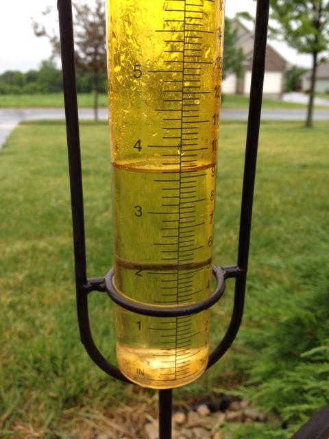
The
Minneapolis/St. Paul Int'l Airport as of 5pm Thursday picked up 2.58"
of rain for the day, which made it a new daily rainfall record
(previous: 1.27" set in 1937)
As of 5pm Thursday, the MSP Airport picked up 3.39" of rain since Wednesday (storm total)
The average May rainfall is 3.36"
That means we picked up a May's worth of rainfall in about 24 hours!
Total precipitation since January 1st is now up to 14.68" (5.86" above normal!)
As
of 5pm Thursday the MSP Airport had 8.19" of rain for May making it the
2nd wettest May on record. 2nd to the 10.33" set in 1906
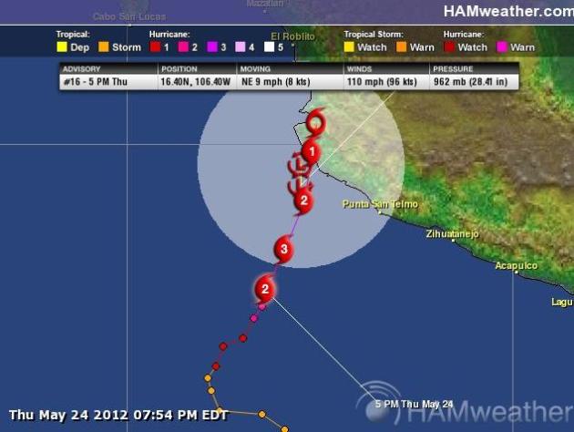
Tropical Update... Still Active
Say
hello to our first hurricane of the 2012 Eastern Pacific Hurricane
Season. Hurricane BUD was a category 2 hurricane on Thursday with wind
gusts topping 100mph.
"Hurricane Bud continues to
strengthen. As of early this afternoon, top sustained winds had reached
110 mph, a strong Category 2 hurricane on the Saffir-Simpson Hurricane
Wind Scale. Some additional strengthening is possible today, with
weakening expected to begin tonight and continue into Saturday.
Bud is centered about 250 miles southwest of Manzanillo, Mexico, moving northeast.
A Tropical Storm Warning and a
Hurricane Watch continues along the Pacific coast from Punto San Telmo
westward to Cabo Corrientes. A Hurricane Warning may be necessary later
today for a portion of the southwest Mexico coastline."

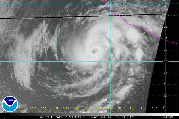

National Hurricane Center
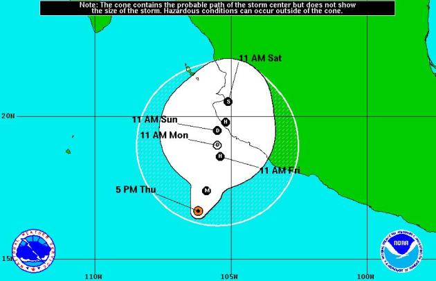
The
current forecast has it briefly warming to a category 2 hurricane
before putting on the brakes prior to making landfall with western
Mexico as a tropical storm. In fact, it throws it in reverse real quick
and weakens to a tropical depression.
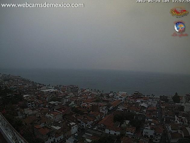
Puerto Vallarta Webcam
It might be worth a look every once in a while at the webcam from Puerto Vallarta, Mexico as BUD nears the west coast of Mexico.
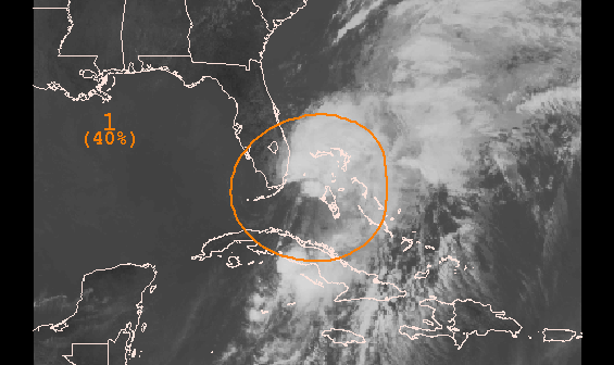
More Activity in the Atlantic Basin
Thanks
to the National Weather Service from Key West, FL for the blurb below
on a potential new tropical cyclone in the Atlantic Basin.
"An area of low pressure over the Middle Keys and Florida Bay
has become better organized during the past few hours. This area of low
pressure is producing tropical storm force wind gusts to the east of
the center over water. Strong wind shear continues to prevent this
storm system from developing into a subtropical or tropical cyclone.
Although conditions are not currently favorable for development, they
are anticipated to become more conducive for the formation of a
subtropical or tropical cyclone by Saturday as the area of low pressure
progresses northeastward into the southwest Atlantic Ocean. Regardless
of development, locally heavy rainfall, flooding, and gusty winds are
possible over south Florida, portions of the Florida Keys, and the
Bahamas this afternoon into Friday."
NOAA Predicts a Near Normal Hurricane Season
Despite
the early start to the Atlantic Hurricane season (Official start of the
Atlantic Hurricane Season is June 1st-November 30th)
"Conditions
in the atmosphere and the ocean favor a near-normal hurricane season
in the Atlantic Basin this season, NOAA announced today from Miami at
its Atlantic Oceanographic and Meteorological Laboratory, and home to
the Hurricane Research Division.
For
the entire six-month season, which begins June 1, NOAA’s Climate
Prediction Center says there’s a 70 percent chance of nine to 15 named
storms (with top winds of 39 mph or higher), of which four to eight
will strengthen to a hurricane (with top winds of 74 mph or higher) and
of those one to three will become major hurricanes (with top winds of
111 mph or higher, ranking Category 3, 4 or 5). Based on the period
1981-2010, an average season produces 12 named storms with six
hurricanes, including three major hurricanes."
Great News for Park Goers!
Great news from Coronado National Memorial Park in Arizona, the park is reopening after a wildfire.
"The park is reopening to the public today, Thursday, May 24,
2012 after being closed for the Campini Fire since Monday
afternoon. The picture from Montezuma Pass Overlook is showing the
burned area in Mexico from the Campini Fire and the School Canyon
Fire."
More wildfire News: New Mexico Baldy Fire
"Fires
in the Gila area of southwest New Mexico from the NASA Terra polar
orbiting satellite. The picture is a little fuzzy due to the position of
the satellite and its field of view as it passed. This was roughly
around noon Wednesday MDT."

Several Fires Burning
Look at all the fires burning in the Southwest. Get all the information HERE:

Satellite of Standing Lenticular Clouds
This
is neat! What looks like a fire, really is not. From the National
Weather Service out of San Diego, CA who shared this on their Facebook
page:
"Standing
wave cloud (lenticular) visible on MODIS 250 km visible satellite
image over Tehachapi mountains. Strong winds have been flowing across
this region the past 24 hours. Ice in this cloud also makes it show up
as a very cold cloud top when viewed on Infrared satellite."

Rain, Rain Go Away?
On
one hand, folks in the Upper Midwest would probably like to see the
rain exit the region before the long Memorial weekend, but on the other
hand, the heavy rain is helping with drought conditions and low lake
levels
Thanks to WNTV Meteorologist Bryan Karrick for the picture below at Cologne Park.

MNDOT Working on Keeping I-694 Open
Thanks
to MNDOT for sharing this on their Facebook page earlier Thursday as
crews worked on keeping I-694 open as heavy rain washed mud into traffic
lanes.

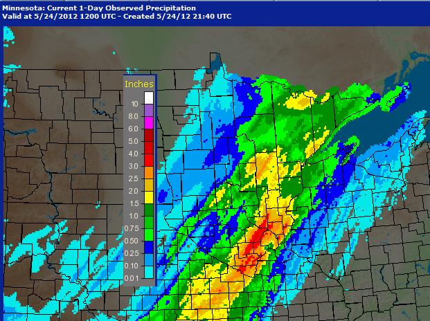
Rainfall From Earlier Thursday
This is a look at how much rain fell from Wednesday through early Thursday across the Twin Cities and places just west. Quite impressive!!

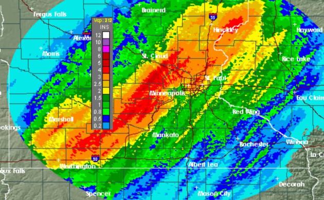
Radar Rain Estimates
The
radar rain estimates show a large swath of 2" to 4" + From southwest
Minnesota to northeast Minnesota from Wednesday through AM Thursday.
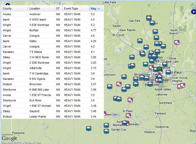
Heavy Rain Reports
This comes from the NWS Storm Report App, see HERE:
The heaviest came in from Andover @ 5.5"
The
Minneapolis/St. Paul Int'l Airport as of 5pm Thursday picked up 2.58" of
rain for the day, which made it a new daily rainfall record
(previous: 1.27" set in 1937)
As of 5pm Thursday, the MSP Airport picked up 3.39" of rain since Wednesday (storm total)
The average May rainfall is 3.36"
That means we picked up a May's worth of rainfall in about 24 hours!
Total precipitation since January 1st is now up to 14.68" (5.86" above normal!)
As
of 5pm Thursday the MSP Airport had 8.19" of rain for May making it the
2nd wettest May on record. 2nd to the 10.33" set in 1906
Twin Cities Climate Journal
"A sluggish cool front brought waves of thunderstorms from southwest to northeast Minnesota on May 23-24, 2012
May is proving to be quite a soggy
month for a good chunk of Minnesota. The latest round dumped from 1 to 3
inches in a swath 75 miles wide from Worthington in southwest
Minnesota, through the western suburbs of the Twin Cities, and then
northeastward to Duluth. The highest total found so far was 5.50 inches
over a 21 hour period in Andover in Anoka County. 5.20 inches was
measured at Montrose in Wright County. Other places with signifigant
rainfall totals ending the morning of the 24th included 2.64 inches in
Golden Valley, Plymouth with 3.59 inches, Maple Grove had 3.24 inches.
Target Field also picked up 2.97 inches.
The
Twin Cities International Airport saw 3.35 inches of rain from the
evening of the 23rd to 4pm on the 24th, making the monthly total 8.14
inches. This is enough for May 2012 to be tied for the 2nd wettest May
on record back to 1871. 1908 also had 8.14 inches. The wettest May on
record in the Twin Cities is 10.33 inches in 1906."
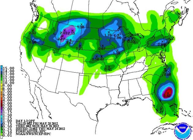
More Heavy Rain Expected!
Unfortunately for those who
have big weekend plans this Memorial weekend, the extended forecast is
looking a little soggy. The 5 day precipitation forecast From PM
Thursday-PM Tuesday) shows an additional 1" to 2" across parts of
northern Minnesota and Wisconsin!
Memorial Weekend Severe Threat
Again, keep up to date with
latest severe weather forecast across the Upper Mississippi Valley this
upcoming weekend. Strong to severe storms and heavy rain will be
possible in the areas shaded below. Sunday is shaded in RED and Monday
is shaded in PURPLE. Those are the two areas (for now) that could be
under the gun for severe thunderstorms during those days. I'm sure a
lot of folks have BBQ plans this weekend, but it might behoove you to
have a plan 'B' just in case you get chased indoors!

NWS Green Bay reports: Record Warm Spring Continues
"After the unprecedented
warm March, spring continues to be mild across much of northeast and
central Wisconsin. In fact, the spring of 2012 will likely go into the
books as the warmest on record in several locations, including Green
Bay and Wausau. As of May 22, here is how spring (March, April, May)
2012 ranks:"

Fleet Week 2012
New York Fleet Week 2012
Thousands of Sailors, Marines and Coast Guardsmen from US Navy and US
Coast Guard ships are in Manhattan for Fleet Week New York.
This cool video showing the Navy Blue Angels Flyover is from Darren Boddy in Edgewater, New Jersey.

Questions:
Hi Paul,
How do I find specific rainfall totals for the area I live in (Mendota Heights). You have the NAM graph but sometimes it’s difficult to know the exact amounts.
Do I need to purchase a rain gauge?
-Matt Steiner
Thanks for the question Matt. The National Weather Service receives weather reports from reporting stations (such as airports), trainers weather spotters and weather observers. The list of rainfall totals are released by the National Weather Service and are relayed to the public. The recent list of rainfall totals can be found HERE: If you don't see weather reports from your area and would like to know, you can always become a weather spotter yourself! The National Weather Service has a Coop Observing program and they're always looking for more observers! See HERE:
Hope that answered your question,
-Todd
___________________________________________________________________________________________
Paul,
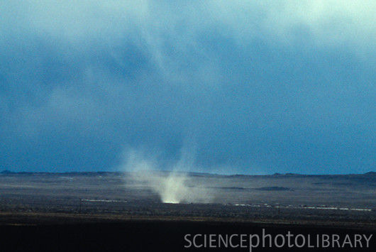
Last Friday May 18th I was camping on Leech Lake. The weather was unsettled to say the least. We already had one thunder storm come up out of the SE in the afternoon. In the evening another one came up east of the campground and went over the east side of the lake. The wind came up within a minute or two. Over the lake we could see a large anvil head with what looked like a water fall coming off of it. In side the water fall was a white spinning feature running from top to bottom. It was probably 10,000' high. I thought it was a water spout embedded in the hard rain. Do you have any thoughts what it might have been?
Regards,
Dan Fix
Dan, it's hard to say exactly what you saw without seeing it myself. Did it look anything like the image below? I pulled the storm report map from the 18th and it showed several hail and high wind reports across the state and as far north as Lake Mille Lacs and Bemidji. There were no tornado reports, but the damaging wind reports from out of the Bemidji area suspected a downburst as a 100yd row of trees was laid down. The leading edge of storms producing damaging straight line winds can sometimes produce what is known as a gustnado. The gustando develops on the front side of the storm and tends to be very weak, while the tornado or water spout would develop near the back of the storm.
Hope that helps,
Todd Nelson
Waterspout
Image courtesy of C.A. Scholz, Department of Earth Sciences, Syracuse, University

Gustnado
Thanks for checking in and have a great rest of your week.
Don't forget to check me out on Twitter @TNelsonWNTV

No comments:
Post a Comment