93 F. high in the Twin Cities Sunday.
77 F. average high for June 10.
62 F. high on June 10, 2011.
+6.1 F. Temperatures through the first 9 days of June are running more than 6 F. warmer than average at KMSP.
38 F. dew point by Tuesday afternoon; within 36 hours there will be half as much water in the air as Sunday.
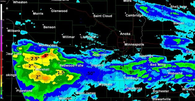 Sunday Soakers
.
A band of 1-1.5" of rain fell over the western metro, some 2 to 2.5"
amounts from near Willmar and St. Cloud to Little Falls and Wadena.
These are Doppler radar estimates.
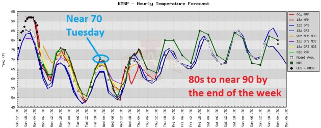
Two Comfortable Days - Heating Up Late Week. Tuesday
will feel like mid September - enjoy the vacation from heat and
humidity, because we heat back up to 90 by Friday. Showers and T-storms
are most likely Wednesday, again Saturday, based on ECMWF model data.
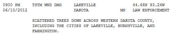
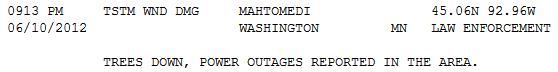
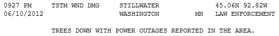
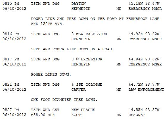
Damage Reports. There were no confirmed tornado
touchdowns, but numerous damage reports from strong straight-line
winds: trees down, numerous power outages. Click
here to see all the damage reports from NOAA.
Comfortable Front. By Tuesday dew points drop into
the 30s to near 40, meaning less than half as much water in the air as
yesterday. Highs return to the 80s later this week, the ECMWF hints at
90+ by Friday.
"
The report from CoreLogic,
a private company that provides financial and property information for
risk management, shows that for the country as a whole, more than 4
million residential structures are at risk from storm surge flooding in a
worst-case scenario storm, with a total estimated price tag of $710
billion." - from a Climate Central story, details below. Photo credit: msnbc.com.
"
It's sort of a mystery right now in our science community as to
why hurricanes intensify or de-intensify," said Chris Velden, a UW
scientist working on the project. "We hope to get some information from
this aircraft to be able to answer those questions." - excerpt from a story at The Milwaukee Journal Sentinel; details below.
“
What’s happening now is that we are changing the climate system,
especially in the Arctic, and that’s increasing the odds for the
negative AO conditions that favor cold air invasions and severe winter
weather outbreaks." - excerpt of an article below the 7-Day.
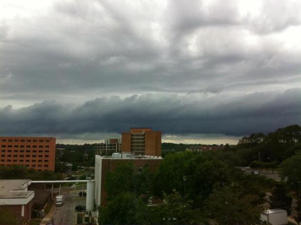
"Shelf Cloud". Here's a great photo and explanation from the Tallahassee office of The National Weather Service, via
Facebook: "
Here’s
a picture taken from our west-facing window a few minutes ago as a
shelf cloud moved over Tallahassee. This cloud formation is caused by
cool outflow from weakening storms that were approaching the area."
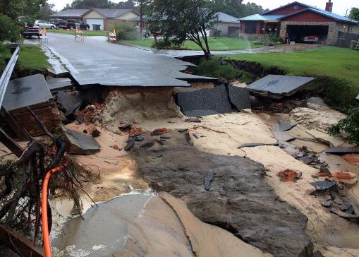
Record Rains Plague Pensacola, Florida. Here's a clip of an article from
Huffington Post: "
Record
amounts of rain dropped on the central Gulf coast Saturday, causing
what could be millions of dollars in flood damage in the Pensacola area
alone with more rain on the way. The National Weather Service said
13.11 inches fell on Pensacola over 24 hours by Saturday, coming close
to the city's all-time record of 15.29 inches set in 1934. The rain hit
a lull by Saturday night, but NWS meteorologist Jason Beaman said they
expected more showers and thunderstorms overnight and more intense
rain again on Sunday and into Monday."
Photo credit above: "
A section of Oak Valley Drive in
Escambia County, Fla., is washed out on Sunday, June 10, 2012, after
heavy rains fell on Saturday, in Pensacola, Fla. Floodwaters from
torrential rains damaged homes and closed roads throughout the Florida
Panhandle, cutting power to the county jail and sending residents to
emergency shelters as the area braced for additional rains Sunday." (AP Photo/The Pensacola News Journal, Tony Giberson) CREDIT: TONY GIBERSON/PENSACOLA NEWS JOURNAL AND PNJ.COM
Florida Floods Close Roads, Cut Power To Jails. Some additional details from
MSNBC.com: "
Floodwaters
from torrential rains damaged homes and closed roads throughout the
Florida Panhandle, cutting power to the county jail and sending
residents to emergency shelters as the area braced for additional rains
Sunday. One swimmer was reported killed. More than 600 inmates at the
Escambia County Jail were without power and air conditioning after the
rains left more than 5 feet of water in the bottom floor, which also
houses the laundry and kitchen facilities. Extra deputies were brought
in to beef up security, and generators powered lights outside the
facility to shine into the jail. Officials worked Sunday to pump out
the excess water and assess the damage."
Photo credit above: Dan Anderson/EPA. "
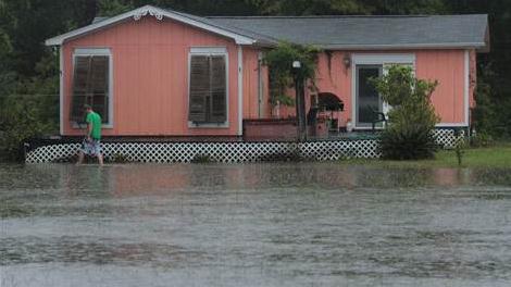
Josh Spinner
inspects his water-surrounded home in Perdido, Fla. Sunday. More than
13 inches of rain has dumped on the area in the last 24 hours,
according to the National Weather Service."
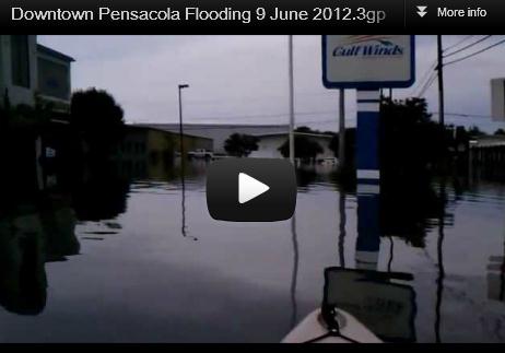
Serious Flooding. A hurricane's worth of rain has
swamped the Florida Panhandle, with some 15+" rainfall amounts in the
Pensacola area. More details (and an amazing video) via
YouTube: "
On
June 9th 2012 several storms rolled in from the southwest over the
Gulf of Mexico. The heavy rainfall caused flooding throughout the
Pensacola region. This video was filmed about 3 hours after the end of
the heaviest rainfall from my kayak immediately north of Fairfield Drive
between NL and NM streets." Video courtesy of
mxracerxxx157
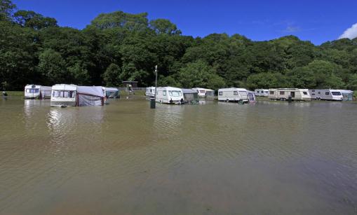
Wales Floods Leave Campsites And Villages Devastated. The Guardian has more on the record rains that have triggered widespread (serious) flooding across Wales, in the U.K.: "
Hundreds
of tourists have been left to survey the wreckage of their holiday
homes after floodwater devastated campsites and villages across west Wales.
Around 150 people were evacuated as up to 1.5 metres (5ft) of water
hit the area around Aberystwyth on Saturday when more than 13cm (5in)
of rain, twice the local average for June, fell in 24 hours. Floodwater
was still in evidence on Sunday, and Andy Francis, of Mid and West
Wales fire and rescue service, said there was "mass-scale damage to
caravan parks and private dwellings" across the area."
Photo credit here: "
The scene at Riverside Caravan Park in
Llandre, Wales after swollen waters breached the banks of the River
Lery and flooded the caravan park Saturday June 9, 2012. Around 150
people had to be rescued from homes and caravans after severe floods
hit west Wales. Holidaymakers and residents were helped to safety in a
large-scale rescue operation mounted by fire crews, coastguard
lifeboats and military helicopters when water swept through caravan
parks and villages near Aberystwyth in Wales." (AP Photo/PA Wire)
* The BBC has some amazing photos of the flooding in Wales
here.
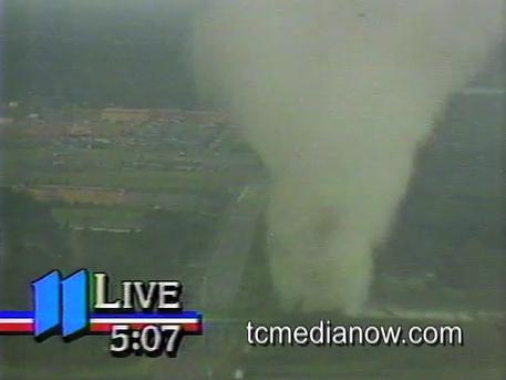
Stay In Your Car During A Tornado? There is some
degree of controversy about this - the notion of staying in you during a
tornado - instead of seeking some measure of shelter from flying debris
in a nearby ditch. If you have a newer-model vehicle, complete with
fancy airbags, this might not be a bad idea. An older car or ditch? I
would opt for a ditch. Of course a building, ANY building, will offer
more protection from the 150 mph. blender of debris whipped up by a
tornado. Details in a
Joint Statement from The American Red Cross and The National Weather Service; here's an excerpt:
The Red Cross and Weather Service believe that if you are caught
outdoors, you should seek shelter in a basement, shelter or sturdy
building. If you cannot quickly walk to a shelter:
• Immediately get into a vehicle, buckle your seat belt and try to drive to the closest sturdy shelter.
• If flying debris occurs while you are driving, pull over and park. Now you have the following options as a last resort:
- Stay in the car with the seat belt on. Put your head down below the
windows, covering with your hands and a blanket if possible.
- If you can safely get noticeably lower than the level of the
roadway, exit your car and lie in that area, covering your head with
your hands.
• Your choice should be driven by your specific circumstances.
The important thing to understand is that if you find yourself
outside or in a car with a tornado approaching and you are unable to get
to a safe shelter, you are at risk from a number of things outside your
control, such as the strength and path of the tornado and debris from
your surroundings. This is the case whether you stay in your car or seek
shelter in a depression or ditch, both of which are considered last
resort options that provide little protection. The safest place to be is
in an underground shelter, basement or safe room.
* screen-grab above courtesy of KARE-11 and
tcmedianow.com.
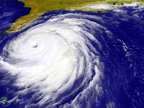
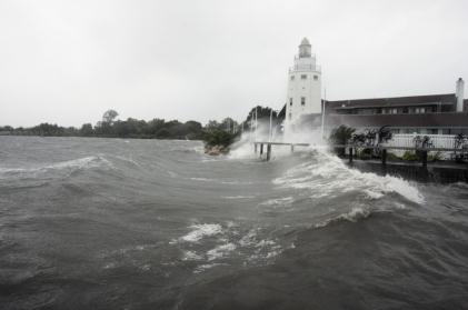
Report: Storm Surge Could Cost U.S. Hundreds of Billions of Dollars. I had to look this over twice to make sure it wasn't a typo - hundreds of billions of dollars?
Climate Central meteorologist Andrew Freedman has the story - here's a snippet: "
A
new analysis highlights the enormous exposure the U.S. has to storm
surge-related impacts, which is one of the most significant hazards
posed by a land-falling hurricane. The report from CoreLogic,
a private company that provides financial and property information for
risk management, shows that for the country as a whole, more than 4
million residential structures are at risk from storm surge flooding in a
worst-case scenario storm, with a total estimated price tag of $710
billion. The report ranks New York City and Long Island as the most
at-risk metropolitan area, where a Category 4 storm could inflict damage
to residential homes of up to $168 billion. “Even a Category 1
hurricane or low-level tropical storm can wreak billions of dollars of
destruction on cities and states many might have previously assumed to
be safe from the strong winds and floods of hurricane events,” the
report said. “Millions of homes are in fact at risk, from Maine to the
southernmost tip of Florida, facing hundreds of billions of dollars in
residential property damage.”
Photo credit above: "
A storm surge from Hurricane Irene batters Montauk, New York in August, 2011." Courtesy: Climate Central.
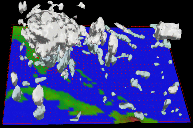
UW Researchers To Study Hurricanes For NASA Project. Details from Milwaukee's
JSOnline.com: "
In
a 15-story building, in the middle of landlocked Wisconsin, a team of
scientists waits for a hurricane. A multimillion-dollar, unmanned
aircraft will start flying from Wallops Island, Va., in September
loaded up with a University of Wisconsin-Madison-engineered instrument
to gather data from tropical storms off the Atlantic coast. The
deployment is the first time UW scientists will take part in a research
project to analyze storm data from a Global Hawk drone, which can
loiter over a storm at 65,000 feet for up to 30 hours - two to three
times longer than a typical aircraft - and cover a greater range."
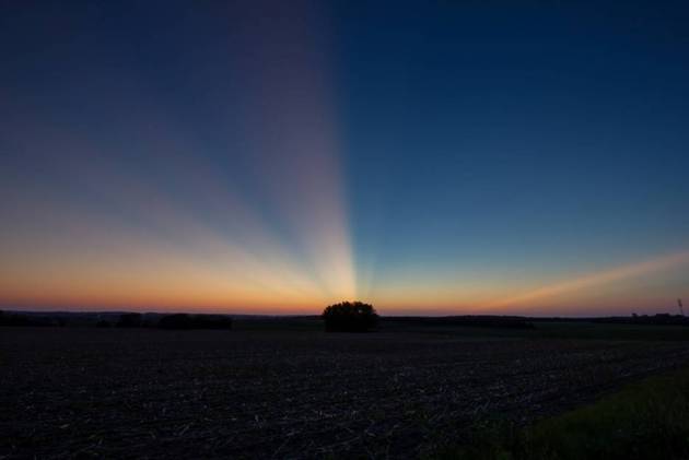
"Ask Paul". Weather-related Q&A.
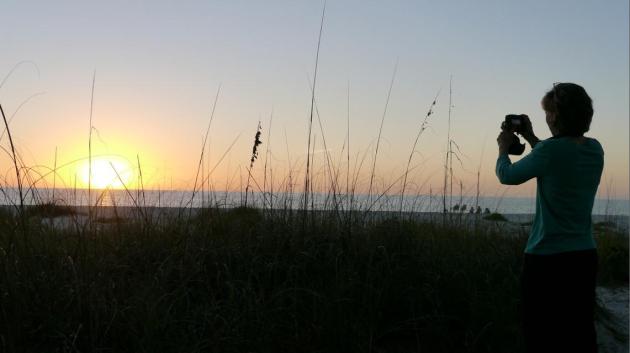
Paul,
"Were there thunderstorms to the west
yesterday? I took these on the way home from Afton SP and was able to
catch the light rays split as they shot over the horizon. I know
mountains will usually do this but wouldn't expect it out here.
Thunderheads?"
Steve Burns
Steve - you took a great photo of crepuscular rays,
sometimes called "twilight rays" caused by sunlight being scattered by
dust in the atmosphere. Your theory is sound - there were (big)
thunderheads over the Dakotas Friday evening around sunset, which may
have blocked out some of those rays, creating the effect above. Well
done!
The Crisis In Europe, Explained. Confused how a few bad banks in Greece and Spain are messing with your 401 account? Me too. This story, from
NPR, goes a long way toward explaining how Europe came to find itself in this mess; here's an excerpt: "
Before
the euro was introduced, governments in Greece, Spain and Ireland,
among others, had to pay a lot more to borrow money than governments
such as France and Germany. But after the euro was introduced, there
was this amazing convergence. Suddenly, all the countries could borrow
at the same rate.
Soros explains the convergence: "When the euro was
introduced the regulators allowed banks to buy unlimited amounts of
government bonds without setting aside any equity capital; and the
central bank accepted all government bonds at its discount window on
equal terms. Commercial banks found it advantageous to accumulate the
bonds of the weaker euro members in order to earn a few extra basis
points. That is what caused interest rates to converge which in turn
caused competitiveness to diverge."
Graph credit above: "
European yields".
Thomson Reuters Datastream
Sunbathing Alert. It turns out Apple and Google are flying planes to get ultra-high-resolution imagery for a new generation of 3-D mapping.
The U.K. Daily Mail has more disconcerting details: "
Spy
plans able to photograph sunbathers in their back gardens are being
deployed by Google and Apple. The U.S. technology giants are racing to
produce aerial maps so details they can show up objects just 4" wide.
But campaigners say the technology is a sinister development that brings
society a step closer. Google admits it has already sent planes over
cities while Apple has acquired a firm using spy-in-the-sky technology
that has been tested on at least 20 locations, including London."
Photo credit above: "
Hyper-real: 3D mapping services used
by C3 Technologies (as purchased by Apple) will form the main part of
the software giant's new mapping service."
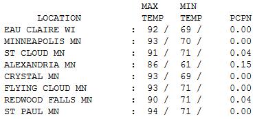
Sunday Sizzler. Highs reached the low to mid 90s
yesterday, 94 in downtown St. Paul, 93 at MSP International, 91 at St.
Cloud. Yes, it was "hot enough for me." Data:
NOAA.
Paul's Conservation Minnesota Outlook for the Twin Cities and all of Minnesota:
TODAY: Blue sky, breezy and less humid. Dew point: 55. Winds: W 15-25. High: 76
MONDAY NIGHT: Clear to partly cloudy and much more comfortable. Low: 48
TUESDAY: Sunny, best day of week. Dew point: 40. High: near 70
WEDNESDAY: More clouds, passing T-shower. Dew point: 55. Low: 55. High: 75
THURSDAY: Some sticky sun, humid, turning warmer. Dew point: 62. Low: 60. High: 85
FRIDAY: Hot & bothered. Sunny. Dew point: 65. Low: 67. High: 92
SATURDAY: Muggy and warm with some sun; T-storms likely. Dew point: 68. Winds: SE 10-20. Low: 68. High: 88
SUNDAY: More sun, still steamy. Dew point: 67. Low: 67. High: 87
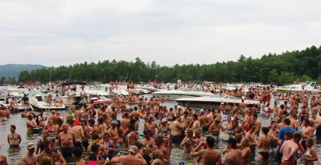
Smoke On The Water
Why do I love Minnesota? The people, the "mild
climate" and the water. Did I mention the water? And was that Snooki out
on Lake Minnetonka's Big Island Saturday?
Assume the guy in the channel in front of you
has had one too many. According to the U.S. Coast Guard alcohol use is
the leading contributing factor in fatal boating accidents. From 2011 to
2012 boating deaths increased nearly 13 per cent nationwide, from 672
to 758, a fatality rate of 6.2 deaths per 100,000 registered
recreational vessels. Have life vests handy: 70% of fatal boating
accidents drowned. Of those 84% weren't wearing a life jacket.
Sorry to be Debby Downer, but I saw stuff on the lake that made me want to make a Citizen's Arrest.
Sunday's noisy, "thundiferous" cool frontal
passage is history. Skies clear out today; dew points dropping to near
40 by tomorrow - meaning HALF as much water in the air as yesterday.
Enjoy the fleeting comfortable front, because we heat up above 90 again
by Friday.
The ECMWF (European) model is doing a
consistently better job, so I'll lean on that simulation for now. It
shows a round of heavy T-storms Saturday - drier/sunnier on Sunday;
weekend highs in the upper 80s.
* photo above courtesy of
TheSkiMonster.com.
Climate Stories...
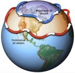
More Evidence: Arctic Effect On Jet Stream = More Extremes.
How could warming in the Arctic (twice as fast as the lower 48 states
of the USA) be impacting our weather, especially winter months? This
story, from
Climate Denial Crock Of The Week connects the dots: "
If you have not seen the video above from my “This is Not Cool” series at Yale Climate Forum,
take some time to watch. It was based on the most current research
that is beginning to explain the increasingly erratic swings in
northern hemisphere weather patterns over recent years. Now a team from
Cornell has published yet another paper underlining those findings,
which explain why climate change is producing not only unprecedented
warm events like this recent spring, but also wild swings into
record-breaking snow and ice storms. Cornell University: The dramatic
melt-off of Arctic sea ice due to climate change is hitting closer to
home than millions of Americans might think. That’s because melting
Arctic sea ice can trigger a domino effect leading to increased odds of
severe winter weather outbreaks in the Northern Hemisphere’s middle
latitudes — think the “Snowmageddon” storm that hamstrung Washington,
D.C., during February 2010."
America's New Energy Reality. American Energy
Independence? No longer a laughable oxymoron. Here's an excerpt of a
vaguely optimistic and encouraging story from Pulitzer Prize winning
author Daniel Yergin in
The New York Times: "
AMERICA
needs a new political discourse on energy. This would recognize the
emerging reality that the United States has turned around as an energy
producer and is on a major upswing. And the impact will be measured not
just in energy security and the balance of payments. Energy
development also turns out to be an engine for job creation and
economic growth — something that would hardly have been considered the
last time we were electing a president. In 2008, the rise in oil prices
was accompanied — and partly fueled — by a belief that an era of
permanent scarcity was at hand. This mentality had deep roots extending
back to the 1970s, when the United States went from being a minor
importer of oil to a major importer. In the 2008 rendition, falling oil
output was considered simply inevitable. The only questions were at
what rate petroleum imports would rise and whether that rate would be
slowed."
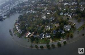
Lawmakers Avoid Buzzwords On Climate Change Bills.
Perception becomes reality when it comes to legislation to rein in
greenhouse gas or mitigate rising sea levels. Here's an excerpt of
interesting story from Hampton Road's
pilotonline.com: "
State
lawmakers ran into a problem this year when recommending a study on
rising sea levels and their potential impacts on coastal Virginia. It
was not a scientific problem or a financial one. It was linguistic. They
discovered that they could not use the phrases "sea level rise" or
"climate change" in requesting the study, in part because of objections
from Republican colleagues and also for fear of stirring up
conservative activists, some of whom believe such terms are liberal code
words."
Photo credit above: "
Mayflower Road in Norfolk’s Colonial Place neighborhood was mostly underwater as high tide approached in November 2009."
(Stephen M. Katz | Virginian-Pilot file photo)


No comments:
Post a Comment