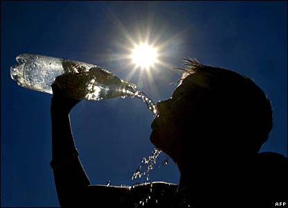
92 F. high Saturday in the cities; three degrees away from the all-time record of 95 in 1976.
77 F. average high for June 9.
68 F. high on June 9, 2011.
+ 5 F. Temperatures through the first 8 days of June are running 5 degrees F. warmer than normal in the cities.
 Severe storm threat
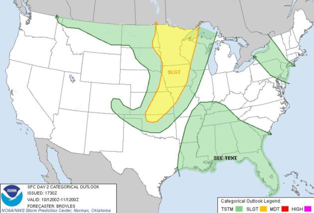
later today: Minnesota is in a "slight risk" according to NOAA's SPC.
That means severe storm watches/warnings are likely later - most likely
between 4 pm and 9 pm.
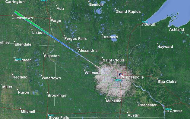
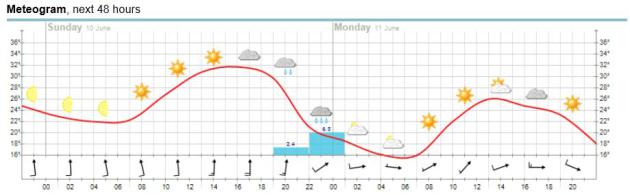 Meteogram.
I've always liked meteograms as a potent way to visualize expected
changes in weather - I think it works much better than text on a page.
The forecast calls for highs peaking around 32 C (93-95 F) by early
afternoon, the best chance of showers and storms this evening and early
tonight. Winds shift around to the west tomorrow, temperatures cooling a
bit (only 80 for a high on Monday, give or take). Source: yr.no.
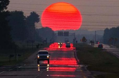
 Hot and Bothered
.
South winds may gust past 30-35 mph at times today, morning sun giving
way to increasing clouds this afternoon, the best chance of T-storms
after 5 pm.
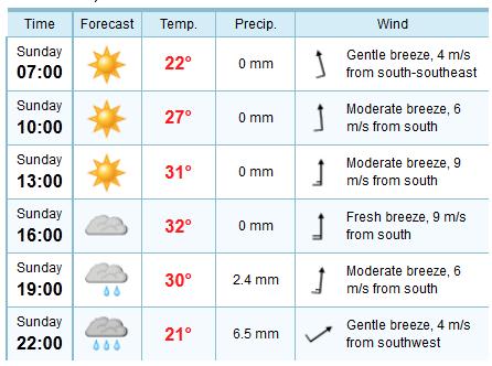
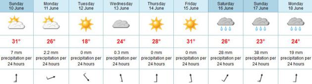
Sunday Databank:
Today: Sunny morning, clouds increase this afternoon with strong/severe storms after 3 or 4 pm. Dew point: 69.
Highs: 90-95 F. Winds: South/southwest: 15-25, gusts over 30 during the midday and afternoon.
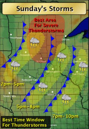 Timing The Front
.
Storms may push into western Minnesota by midday, but I think dry
(windy, stinking hot!) weather will prevail in the metro area until 4 or
5 pm. The best chance of strong to severe storms will come around the
dinner hour.
Map courtesy of the Twin Cities NWS office.
 Sunday Severe Threat.
An eastbound surge of much cooler, drier Canadian air will act as a
trigger, creating enough low-level convergence to initiate convection -
strong to severe storms most likely later today from Minnesota and
western Wisconsin southward to Wichita and Tulsa. Source:
SPC.
 Extended Outlook
. I'm highlighting the ECMWF
(European)
model just about every day now, because frankly (sadly) it seems to be
doing a consistently better job than the U.S. (GFS)
model,
at least recently. Tuesday looks like the most comfortable day of the
week: highs in the 60s to low 70s. We heat up to 90+ again by Friday,
the latest ECMWF model run hinting at a few inches of rain next weekend from heavy T-storms. I hope the model is wrong...
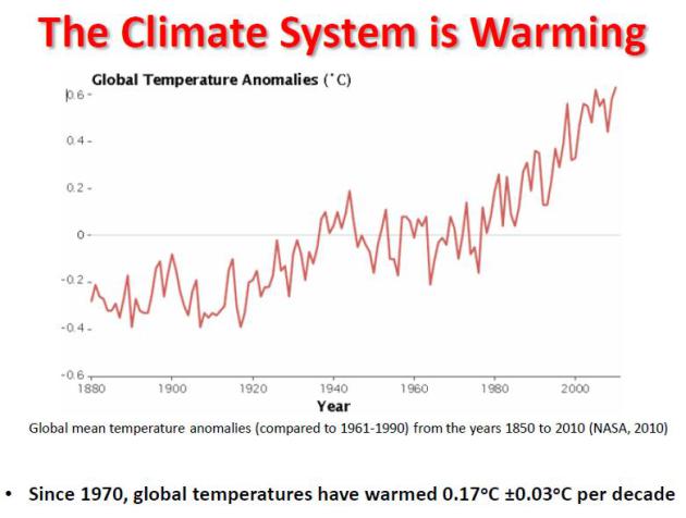
900+ high temperature records tied or broken in Minnesota in the last 12 months, according to Dr. Mark Seeley. Details below.
"Each of the 12 months
from June 2011 through May 2012 ranked among the warmest third of their
historical distribution for the first time in the 1895-present record.
According to NCDC, the odds of this occurring randomly during any particular month are 1 in 531,441.
Thus, we should only see one more 12-month period so warm between now
and 46,298 AD--assuming the climate is staying the same as during the
past 118 years." - from Dr. Jeff Master's latest Wunderblog; details below.
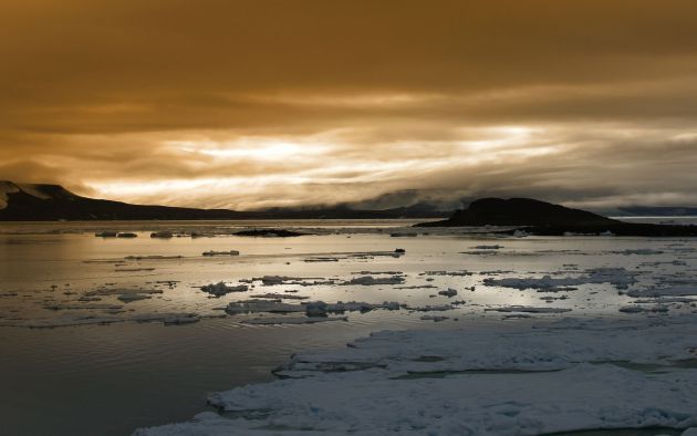
"
As the Arctic thaws, that prevailing westerly (jet stream wind)
flow has slowed measurably, by 20 percent in the past few decades." - from an article about the impact of Arctic warming on America's winters; details below.
64.4 F. average spring temperature at Wichita,
Kansas (almost 8 F. warmer than average), making it the warmest spring
in over 120 years. Source:
Wichita office of The National Weather Service.
900+ Minnesota High Temperature Records In The Last 12 Months. It's a staggering number - tabulated by Dr. Mark Seeley in his weekly
WeatherTalk Blog. Here are a few highlights (that made my jaw drop): "
The
estimated total number of daily maximum temperature records set or
tied in Minnesota over the past 12 months is at least 900, bearing in
mind a like or greater number of record high minimum temperatures is a
probable value as well. During the same period from June 2011 to May
2012, 13 new statewide high temperature records were set, and one was
tied. This level of statewide extremes in maximum temperature has not
been seen since the 1930s."
Number of Minnesota High Temperature Records (according to Mark Seeley):
2011
27 June 2011
26 July 2011
2 August 2011
12 September 2011
58 October 2011
11 November 2011
69 December 2011
2012
191 January 2012
12 February 2012
434 March 2012
14 April 2012
35 May 2012
Photo credit above: Matt McKean, AP.
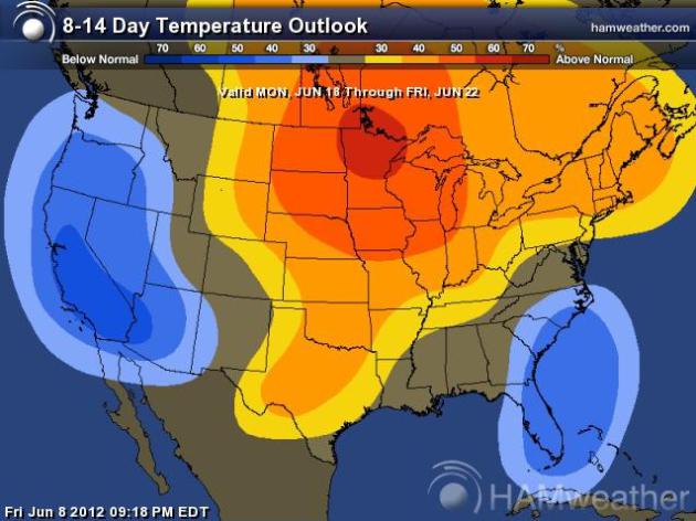
8-14 Day Temperature Outlook. Here is the forecast
trend looking out 2 weeks, according to NOAA CPC, showing a high
probability of significantly warmer than average temperatures through
the third week of June. Map:
Ham Weather.
Spring 2012: Most Extreme Season In U.S. History. Here's an excerpt from Dr. Jeff Master's must-read
Wunderblog: "
Spring
2012 in the contiguous U.S. demolished the old records for hottest
spring and most extreme season of any kind, said NOAA's National Climatic Data Center (NCDC)
on Thursday. With the warmest March, third warmest April, and second
warmest May, the March - April - May spring season was 5.2°F above
average--the largest temperature departure from average of any season on
record for the contiguous United States. What's truly remarkable is
the margin the old record was broken by--spring 2012 temperatures were a
full 1°F above the previous most extreme season, the winter of 1999 - 2000.
All-time seasonal temperature records are very difficult to break, and
are usually broken by only a tenth of a degree. To see the old record
crushed by a full degree is a stunning and unparalleled event in U.S.
meteorological history. "
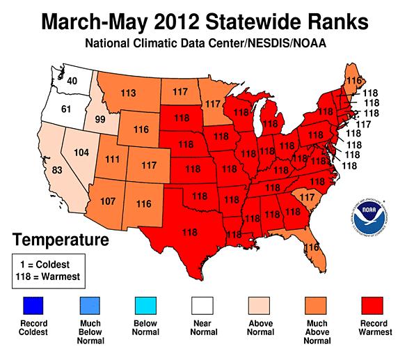
Graphic credit above: "
Temperature
rankings for spring 2012 in the Contiguous U.S. Thirty-one states were
record warm for the 3-month period, and an additional eleven states
had top-ten warmth. Spring 2012 beat the previous record for hottest
spring on record, set in 1910, by an remarkable 2°F. Image credit: NOAA/NCDC."
 Western Tornadoes (Rare, Not Impossible) Hit Wyoming, Colorado
. Details (and a compelling video) from the
L.A. Times: "
Parts of Wyoming and Colorado were working Friday to recover from the
week's harsh weather, including tornadoes that caused minor injuries. A rare tornado cut through open country in southeastern Wyoming
on Thursday, injuring at least one person and causing some property
damage in the Wheatland area. In Colorado, four tornadoes were reported
in the Elbert County area, southeast of Denver. A minor injury was also
reported there."
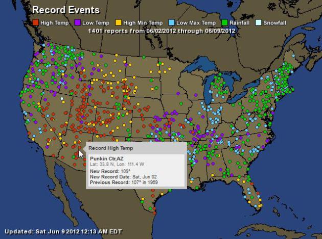
Record Events. Here are the towns that registered
record highs, lows and 24 hour rainfall amounts in the last 7 days. Data
courtesy of NOAA and
Ham Weather.
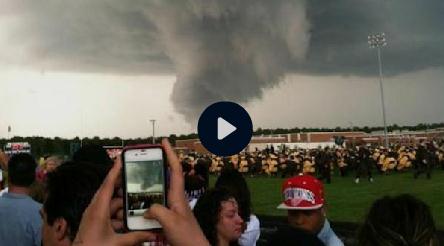
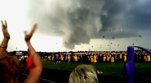
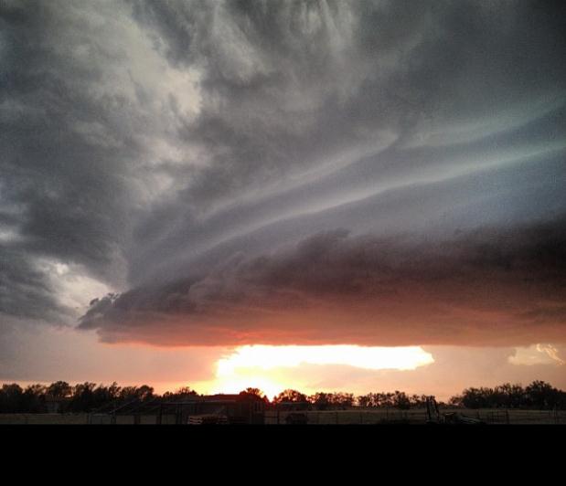
Wild Wall Cloud Scares New Jersey Graduates. Yes, if
you see a rotating cloud like this it probably can't be good - in this
case there was a lowering cloud base, but no tornado. Details (and
remarkable video) from Philadelphia's WPVI-TV,
6abc.com: "....
But
was it a tornado? Action News Meteorologist Cecily Tynan says no. On
Action News at 11, Cecily explained that what graduates and their
families saw was what's known as a wall cloud or pedestal cloud. It
forms when the base of a storm cloud extends towards the surface of the
ground. A wall cloud is in the area of the strongest updraft. If there
was rotation, a tornado could likely have formed, but since there was
no rotation in the storm, there was no chance for a tornado."
"What Was That Thing?" It wasn't a tornado - no
debris - the circulation never reached the ground and triggered damage,
but there is a difference of opinion in meteorological circles about
what formed in the skies above New Jersey. Here's an excerpt from The
Washington Post's
Capital Weather Gang: "
CWG’s Ian Livingston, who just spent two weeks storm chasing in the Plains and blogged earlier today about identifying scary storm types, offers the following explanation: Watching
the video, and examining radar from the time of the storm, it appears
the low-hanging cloud is a shelf cloud / outflow type feature with
scud-type clouds associated with it. At times, the videographer pans up
enough to see a “line” of similar low hanging clouds going up above
their head (and presumably further). A rain curtain to the left, likely
“behind” the low clouds, tends to back this up."
Photo credit above: "
Screenshot from video of Galloway Township, NJ storm. Video uploaded to YouTube by MatthewRBlanchard on June 7."
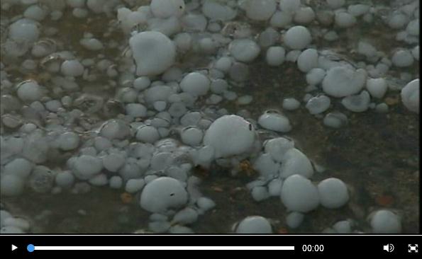
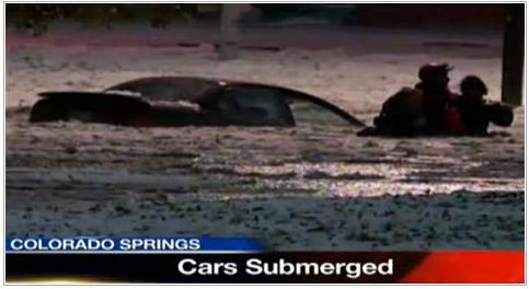
Hail, Flooding Swamp Cars In Colorado. The
Denver/Colorado Springs area has taken a pounding in recent days:
tornadoes, flash flooding and enough hail to call out the snow plows!
MSNBC.com has more details: "
Six
tornadoes touched down across northeast Colorado on Wednesday,
including one near Denver's airport, though none caused any damage. But
golf-ball sized hail punched holes in car windshields and combined with
heavy rain to flood streets in Colorado Springs, where NBC affiliate
KOAA-TV lost count of the numerous water rescues. "Holy hail," was how KOAA-TV anchor Rob Quirk began his broadcast Wednesday night.
KOAA video showed a person being rescued from a car swamped by hail
and water at an intersection near a mall, one of 10 rescues at that site
alone."
Photo credit above: "
Hail and floodwaters swamped this
vehicle in Colorado Springs Wednesday night. A rescuer is seen helping
someone from the vehicle, in this video clip from NBC Affiliate KOAA-TV."
Wednesday's Storm: "1 in 100 Year Event". Details from
KRDO.com: "
Mayor
Steve Bach called the massive storm a “once in 100-year storm.” The
Mayor said there were 21 home rescues and 25 car rescues throughout the
course of the evening. No one was injured or killed in the storm and
Mayor Bach says everything worked the way it should to keep people safe."
Photo above courtesy of aliving00 and
Instagram.
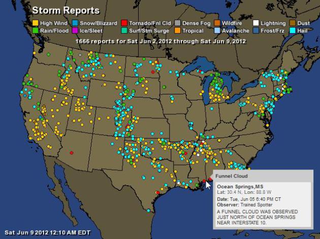
7 Days Worth Of Severe Storm Reports. 1,666 severe reports in the last 7 days, according to NOAA. For an interactive map from Ham Weather
click here.
7 Unusual Tips For Hurricane Preparedness. Here's an excerpt of an article from
The Milwaukee Journal-Sentinel:
* "Buy a local/state map: Whether you are waiting out the storm
or are forced to evacuate, a local and/or state map is essential. When
the power goes out, your GPS might not be fully charged or fully
functional, so a map will ease many headaches when either finding the
quickest way out of town or getting around closed/blocked roads.
* Do your laundry and dishes ahead of time: Having all of your
clothes, towels and dishes clean and ready to go will not only give you
more resources during the storm, but you also won't have to worry about
finding a place to wash them since you will have lots of clean ones on
hand.
* Place towels along window sills and the bottom of doors leading
outside: The towels will act as an extra barrier to keep water from
seeping into your home. This is especially important for any windows or
doors on lower levels and in basements."
9 Months After Irene, People In North Carolina Still Suffer. Details from
boston.com; here's a snippet: "
As
winds from the second named storm of the 2012 hurricane season picked
up speed, the sounds of recovery from the only hurricane to hit last
year still echoed through a rural area across the water from North
Carolina’s Outer Banks. Buzz saws, nail guns and other power tools
competed for attention with birds and frogs as almost 1,700 volunteers
from a group called Eight Days of Hope carried out their work in Pamlico
County. They pulled out insulation and Sheetrock, put down new
flooring and replaced electrical outlets submerged when Hurricane Irene
roared through eastern North Carolina in August before tearing a path
up the East Coast."
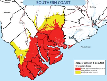
Hurricane Evacuation Survey Shows Many Along Coast Don't Know If They Are At Risk For Storm Surge.
You would think you'd want to know if you live in a potential hurricane
storm-surge flood-zone, but the reality suggests something else.
Details from Charleston's
Post and Courier:
"Too many people who live in the riskiest places for storm surges say
they wouldn’t evacuate unless a major hurricane threatened. At least
one-third aren’t sure if they live in a place that could be flooded by a
storm surge from a less powerful storm. Three in every 20 who do live
there think they don’t....Partly because of the survey, hurricane
evacuations will now be called for in
specific areas based on surge zones. Those zones can be viewed in the
S.C. Emergency Management Division’s 2012 Hurricane Guide."
Map above courtesy of the
South Carolina Emergency Management Division.
Weather Service May Impose Furloughs.
The Washington Post has the story; here's an excerpt: "
The National Weather Service notified
lawmakers Thursday that it plans to furlough up to 5,000 employees for
13 days between July and September if Congress and the agency cannot
find $36 million to cover its budget deficit. Weather Service officials
acknowledged to legislators, as well as the union, that requiring
employees to take unpaid leave could disrupt critical weather
operations at the peak of the hurricane season. But with labor
costs of $2 million a day, the Weather Service cannot pay its employees
through the end of the fiscal year in September without a solution to a
problem of its own making. An internal investigation concluded that
for years, the agency reallocated millions of dollars that Congress
approved for other projects to pay employees."
Death Ray? No worries, it's just the MPX
(Chanhassen) National Weather Service Doppler detecting the setting sun
at 9 pm Friday evening. If you check the radar frequently you'll notice
these beams of energy at sunrise and sunset. Yes, it's reassuring
knowing that Doppler can detect rain, hail, tornado circulations, dust,
insects, birds and even..the sun.
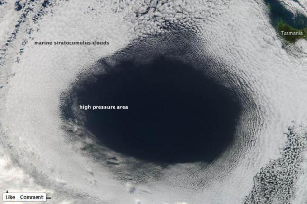 A Sudden Urge For Donuts
.
How's this for evidence of a high pressure bubble (near Tasmania),
warming, drying, sinking air under this high pressure system. More from
NASA's Earth Observatory, via
Facebook: "
High-pressure weather systems often bring fair
weather and relatively clear skies. In early June 2012, a high off the
coast of Tasmania did just that...and in spectacular fashion."
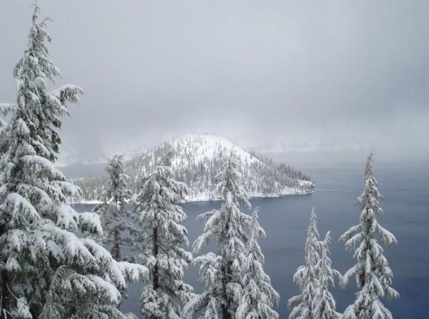
Spring Optional. It doesn't look much like spring up at Crater Lake, Oregon - details from The National Park Service, via
Facebook: "
Every
once in a while, Wizard Island peeks out from under the snow clouds.
Come and see it here at Crater Lake National Park tomorrow, June 9th
for National Get Outdoors Day. Admission to the park is free for the
day!"
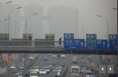
China Says Only It Has Right To Monitor Air Pollution.
Sadly, everyone living in China has to breathe the lousy air, but only
Chinese authorities can actually measure the level of pollution. Makes
perfect sense to me. More from
Reuters: "
A
senior Chinese official demanded on Tuesday that foreign embassies
stop issuing air pollution readings, saying it was against the law and
diplomatic conventions, in pointed criticism of a closely watched U.S.
embassy index. The level
of air pollution in China's heaving capital varies, depending on the
wind, but a cocktail of smokestack emissions, vehicle exhaust, dust and
aerosols often blankets the city in a pungent, beige shroud for days
on end. Many residents dismiss the common official readings of "slight" pollution in Beijing as grossly under-stated."
 Invasive Species Ride Tsunami Debris To U.S. Shore
. Just what we need: more invasive species crowding out the stuff that's been growing for millenia.
MyWay News from AP has the fascinating and vaguely troubling story; here's an excerpt: "
When
a floating dock the size of a boxcar washed up on a sandy beach in
Oregon, beachcombers got excited because it was the largest piece of
debris from last year's tsunami in Japan to show up on the West Coast.
But scientists worried it represented a whole new way for invasive
species of seaweed, crabs and other marine organisms to break the
earth's natural barriers and further muck up the West Coast's marine
environments. And more invasive species could be hitching rides on
tsunami debris expected to arrive in the weeks and months to come."
Photo credit above: "
This
June 7, 2012 photo provided by the Oregon Park and Recreation
Department shows an exotic mussel attached to a dock float that washed
up on Agate Beach near Newport, Oregon. Scientists are worried that
other debris from the 2011 tsunami in Japan could represent a new way
for invasive species to reach American shores. (AP Photo/Oregon Parks
and Recreation Department)."
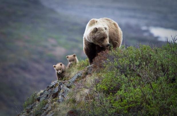
The Bear Necessities. From Denali National Park and Preserve, via
Facebook: "
Denali
is no place for the timid. These tiny cubs seemed oblivious to the
steep drop below them as they played in the remaining midnight light."
iPhone 5: What We Think We Know. Details, rumors and pure speculation from those uber-geeks at
gizmag.com: "
As
the fifth anniversary of the original iPhone's launch approaches later
this month, the Apple rumor mill has been particularly active and
everything from a larger screen, radical case design and all-new dock
connector have been cited as forthcoming alterations to Apple’s flagship
mobile device. While nobody outside Apple’s inner circle can be sure
exactly what the famously tight-lipped company has planned for the
iPhone, a skeptical reading of rumors makes it possible to build up a
picture of what we know, or rather what we think we know, so far."
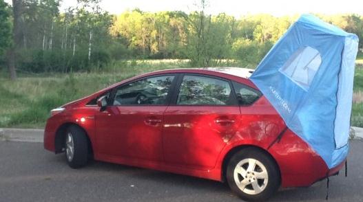
"Habitents": The Toyota Prius Camper. Now I've officially seen everything; details from
gizmag.com: "
We're
used to seeing campers and trailers here at Gizmag. Typically, they're
made for big, gas-drunk trucks, SUVs and vans - vehicles with the size
and hauling capacity to spend the night in. What we're not used to
seeing is campers made for small, fuel-frugal hybrids. But the
Habitents is just that - a camper extension for the Toyota Prius."
Congratulations Class of 2012! Here are a few
excerpts from a particularly well-done segment on Friday's "NBC News
with Brian Williams" that resonated with me. The entire video clip (well
worth watching) from msnbc.com is
here.
"
Life is full of contradictions. You want wealth? Create value for others. If you want to fly - fall down often."
- Newark Mayor Cory Booker
"
The key to success is continually maintaining an ever-present curiosity."
- Supreme Court Justice Sonia Sotomayor
"
You're going to fall down, but the world doesn't care
how many times you fall down, as long as it's one fewer than the number
of times you get back up."
- Screenwriter Aaaron Sorkin
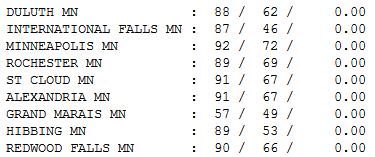
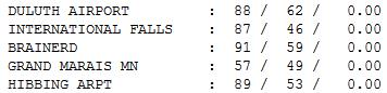
Saturday Stats.
With the exception of the North Shore (poor Grand Marais "peaked" at 57
Saturday) just about everyone saw upper 80s and low 90s yesterday; 91
at St. Cloud - 92 in the Twin Cities.
 Paul's Conservation Minnesota Outlook for the Twin Cities and all of Minnesota:
TODAY:
Sizzling sun. Windy with increasing PM clouds. Severe storms possible by late afternoon. DP: 68 S 25+. High: 94
SUNDAY NIGHT:
T-storms, some severe evening hours, cooling off a bit late. Low:
63
MONDAY: Sunny & comfortable. Dew point: 55. High: near 80
TUESDAY: Blue sky - free A/C. Dew point: 46. Low: 55. High: 72
WEDNESDAY: More clouds, few T-showers likely. Low: 58. High: near 80
THURSDAY: Steamy, strong T-storms. Dew point: 67. Low: 65. High: 89
FRIDAY: Hazy sun, tropical heat. Dew point: 69. Low: 67. High: 91
SATURDAY: Warm, sticky & stormy. Locally heavy rain? DP: 71 Low: 68. High: 89
SUNDAY: More heavy showers and T-storms, a few downpours. Low:
70. High:
86
1 in 531,441
I respond to data, where the numbers &
trends lead me. The odds of recent heat records being random are about the same
odds of me being drafted into the NFL.
"Each of the 12 months from
June 201 through May 2012 ranked among the warmest third of their
historical distribution for the first time in the 1895-present record.
According to NCDC, the odds of this occurring randomly during any particular month are 1 in 531,441" reports Dr. Jeff
Masters in his Wunderblog (link on my blog).
Dr. Mark Seeley writes
"The estimated total number of daily maximum temperature records set or
tied in Minnesota over the past 12 months is at least
900." Seeley reports 13 new statewide high temperature records tied or
broken since June 2011. "This level of statewide extremes in maximum
temperature has not been seen since the 1930s."
It's
getting warmer out there. No kidding Paul. Mid 90s are likely by 3 pm, before a
swarm of strong/severe storms arrive by the dinner hour. Stay alert later today.
Canadian air cools us off into Tuesday, but heat and
numerous T-storms return from Wednesday into next Sunday. Highs poke into the
90s again by next weekend.
The extended outlook: "Stinking
Hot!"
Climate Stories...
 NASA Hints That Thinning Arctic Sea Ice May May Slow Impact Of Global Warming
. The plankton will save us! Hopefully. Details from
The Capitol Column; here's an excerpt: "
Turns
out that increased amounts of CO2 could actually help the planet stave
off the effects of global warming. That is the consensus of a team of
NASA scientists, according to a
newly published report, which finds that a growing body
of microscopic plants may eventually provide the Arctic ice with
additional time. NASA researchers say microscopic plants could serve as a
solution to
increasingly high rates of CO2, one of the key contributors to global
warming. The team of scientists suggest that the large quantities of
phytoplankton, recently discovered growing under sea ice, could pull in
large amounts of the greenhouse gas, possibly curtailing any potential
consequences of global warming."
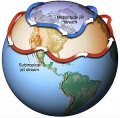
Global Warming: Cornell Researchers Say Arctic Ice May Be Setting The Stage For More Extreme Winter Weather. Details from
The Summit County Citizens Voice: "
Evidence
continues to mount that melting Arctic ice is having a significant
effect in the mid-latitudes, where most people live, and it’s not
something that’s going to take decades to develop. Instead, researchers
say, the warming of the high latitudes has decreased a historic
pressure gradient at the boundary of the high- and mid latitudes.
Basically, the pressure difference has decreased, and that is having a
fundamental effect on the way the jet stream moves from west to east in
the northern hemisphere. The jet stream is a high-elevation, high-speed
river of air that drives storm systems. Historically, there are
variations in the flow of the jet stream, which also influenced by
seasonal and decadal variations in sea surface temperatures and other
factors."
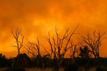
Climate Change To Bring More Severe Wildfires To British Columbia: Report. Here's an excerpt from
The Vancouver Sun: "
The
number of major forest fires in B.C. will likely increase by 50 per
cent or more in the next 40 years according to a recent report on
climate change. Telling the Weather Story, released this week by the
Insurance Bureau of Canada, addresses altering weather patterns across
the country in the coming decades and urges Canadians to adjust to the
realities of climate change. The study predicts B.C. can expect an
increase in wildfires over the average of nearly 2,000 blazes a year
between 2000 and 2010. Furthermore, the province will likely see a host
of other weather-related issues like warmer temperatures, declining —
and, in some regions, disappearing — mountain snowpacks, more intense
rainfall during the winter, and drier summers. The number of wildfires
sparked by lightning strikes — responsible for nearly 60 per cent of
fires — is also expected to rise."
Photo credit above: "The number of major forest fires in B.C.
will likely increase by 50 per cent or more in the next 40 years,
according to a recent report on climate change. Telling the Weather
Story, released this week by the Insurance Bureau of Canada, addresses
altering weather patterns across the country in the coming decades and
urges Canadians to adjust to the realities of climate change." File
Photo: Joshua Lott, Reuters
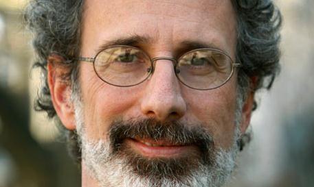
Climate Change Deniers Blinded By Political Ideology. Here's an Op-Ed from climate scientist Michael Mann in The Vancouver Sun: "
A
recent commentary by Frank Hilliard of the Individual Rights Party of
B.C. that appeared in The Vancouver Sun June 4 misinformed readers when
it comes to the reality and seriousness of human-caused climate
change. Further, Hilliard's tirade was riddled with fabrications and
dishonest personal attacks against me and other climate scientists.
Hilliard demonstrates that he does not understand the so-called "Hockey
Stick" graph that my co-authors and I published more than a decade
ago, which demonstrated that the nature of recent warming is
unprecedented. Our temperature reconstruction was based on hundreds of
climate "proxy" records around the world, including tree-ring data from
every continent as well as ice cores from polar regions, coral records
from the tropical oceans, and other sources of information. Yet,
Hillard claims they were based only on "one set of observations of tree
rings in Russia." That is simply a blatant fabrication."
Peter Gleick Reinstated By Pacific Institute Following Heartland Expose. Details from
The Guardian; here's an excerpt: "
The
scientist who exposed the inner workings of the ultra-conservative
Heartland Institute, triggering the defection of key donors, has been
reinstated after an investigation. Peter Gleick, who impersonated a
Heartland board member to obtain and make public confidential budget
and strategy documents, was restored to his position as president of
the Pacific Institute, the organisation announced on its website. The
Pacific Institute indicated in the statement that it had found no
evidence for Heartland's charges that Gleick had forged one of several
documents he released last February."
Photo credit above: "
The Pacific Institute gave every
indication that Gleick would suffer no further sanctions for his
actions, beyond his brief leave of absence." Photograph: Paul Chinn/The Chronicle.
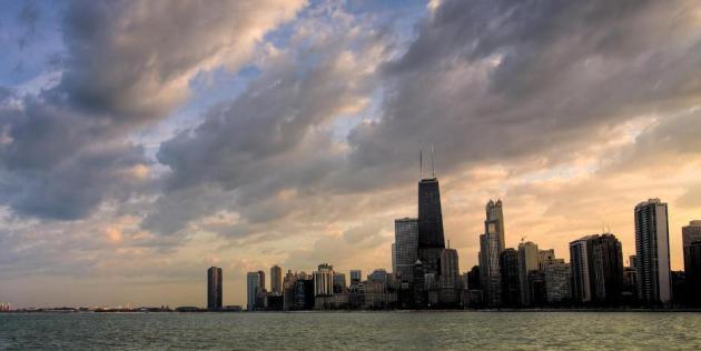
Fighting Climate Change, One Gorgeous Building At A Time: Chicago Commercial Building Initiative. Here's a story from
Huffington Post: "
Yesterday,
Mayor Rahm Emmanuel announced plans to tackle one of the biggest
sources of greenhouse gases in Chicago (or any city), and a key part of
the City’s economy at the same time -- the energy we use in commercial
buildings. With the mayor’s leadership, 14
of the biggest and most recognizable downtown buildings have signed up
to be leaders in creating a leaner, cleaner and more sustainable and
affordable city, by curbing their energy use by at least 20 percent
over the next five years. This initiative is smart business for
Chicago. It cuts one of the biggest expenses for most property owners
by using less energy. And it eliminates vast amounts of carbon
pollution by cutting down overall energy use -- that’s less coal and
natural gas burned with all the associated impacts the quality of our
air. It also makes our buildings more resilient, physically and
economically, while boosting the local retrofit industry and jobs for
building trades. This sets up a robust, growing source of new jobs here
in Chicago that cannot be outsourced."


Cool blog. Check out my "Garmin Golf Watch" blog.
ReplyDeleteGarmin Golf Watch