90 F. high on Monday in the Twin Cities.
80 F. average high for June 18.
72 F. high last year, on June 18, 2011.
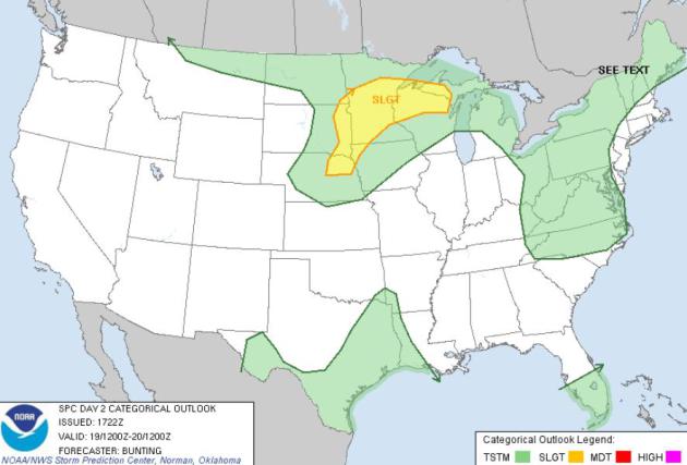
Severe risk today: much of Minnesota is in a "slight risk" area, including the Twin Cities.
93-95 F. predicted high today; a dew point close to 72 F. will make it feel like upper 90s by afternoon.
1.09" rain reported from 7 pm Sunday to 7 pm Monday.
18.67" rain since January 1 (6.6" above average, to date).
Flash Flood Watch. The
local NWS office
has issued a flood watch for much of Minnesota. The ground is saturated
from recent rains; another 1-3" of rain is possible by Wednesday
morning - much of that water will almost immediately run off into
streams, streets (and some basements). Details:
...HEAVY RAINFALL POSSIBLE TUESDAY AND WEDNESDAY...

.A FLASH FLOOD WATCH HAS BEEN ISSUED FOR MUCH OF CENTRAL AND
SOUTHERN MINNESOTA ALONG WITH A SMALL PART OF WEST CENTRAL
WISCONSIN FROM TUESDAY THROUGH WEDNESDAY. SOME LOCATIONS IN THE
WATCH AREA INCLUDE LITTLE FALLS...MORA...ST. CLOUDY...WILLMAR...
HUTCHINSON...THE TWIN CITIES METROPOLITAN AREA...OWATONNA...
RED WING...RIVER FALLS...NEW RICHMOND AND BALSAM LAKE.

SEVERAL ROUNDS OF THUNDERSTORMS WILL OCCUR TUESDAY AND WEDNESDAY AS
A WARM FRONT LIFTS NORTH ACROSS THE AREA ON TUESDAY FOLLOWED BY A
COLD FRONT TUESDAY NIGHT AND WEDNESDAY. TORRENTIAL RAINFALL MAY
OCCUR IN THE THUNDERSTORMS WITH RAINFALL RATES OF 2 INCHES AN HOUR
LIKELY. THE GROUND IS QUITE WET FROM PREVIOUS RAINFALL OVER THE
PAST TWO WEEKS AND REPEATED ROUNDS OF HEAVY RAIN WILL LEAD TO
SIGNIFICANT RUNOFF ALONG WITH FLASH FLOODING. RAINFALL TOTALS OF 3
TO 6 INCHES ARE POSSIBLE BY LATE WEDNESDAY IN AREAS WHERE REPEATED
ROUNDS OF THUNDERSTORMS TRAIN.
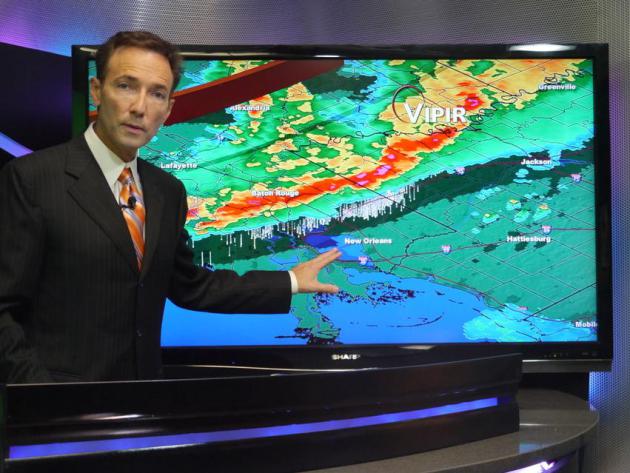
Tuesday Severe Risk. It's like clockwork - we seem
to get nailed with hail and high water every other day. You could almost
set your watch to these waves of severe storms.
SPC
has much of the eastern Dakotas, Minnesota and northern Wisconsin in a
"slight risk" of severe storms today, meaning damaging hail,
straight-line winds, even a few isolated tornadoes.
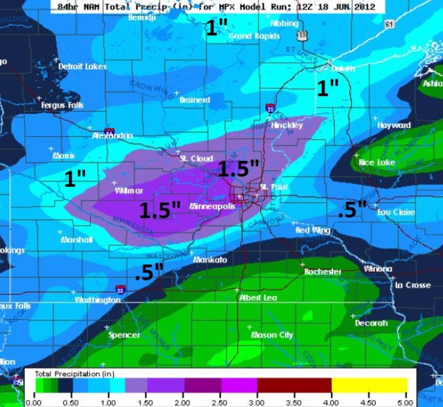
Rainfall Potential. The 00z NAM is predicting some
1-1.5" rainfall amounts by Wednesday evening over the northern and
western suburbs of the Twin Cities, the heaviest rain band extending
into St. Cloud and Hinckley.
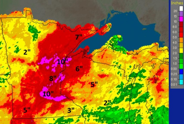
30 Day Rainfall Estimates.
NOAA
posted this map, showing Doppler radar rainfall estimates since May 17.
The southern and western suburbs of the Twin Cities have seen over 10"
of rain; just as much from near Cross Lake and Crosby to the Duluth
area. Meanwhile much of the Red River Valley has only seen 2-3" of rain,
which is closer to average for a 4 week period. The ground is
saturated, waterlogged - meaning any additional heavy rain will quickly
run off into streets and streams. Thus the Flash Flood Watch.
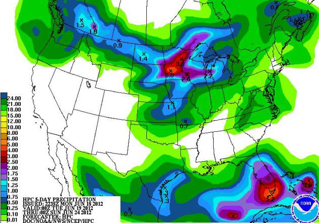
Soggy Bullseye. The latest NOAA HPC 5-day rainfall
forecast shows some 2-4" rainfall amounts over Minnesota, as much as 5"+
over the Florida Keys. Meanwhile most of the southwest remains
tinder-dry, only light showers and widely scattered T-storms for the
northeastern USA.
"
Last week in Virginia, the General Assembly approved a study on
the effects of sea-level rise only after references to “sea level rise”
were removed. The phenomenon has been rechristened “recurrent
flooding.” References to “climate change” have similarly disappeared
from the official Virginia lexicon." - from an article at
KansasCity.com. A great overview on the climate change equation, and why
it's time to do something (now) from Grist.com below.
"
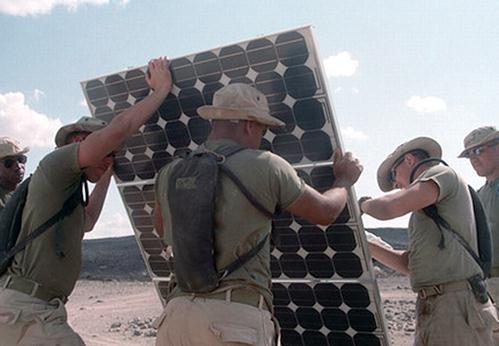
Retired Vice Admiral Dennis McGinn added:
“There is not a shred of political correctness in what the military is
doing with energy efficiency or renewable energy. From lance corporal
to general, they are on board. They live with the problems from the
over-reliance on fossil fuels.” Jon Soltz, an Iraq war veteran, underscored
this point in a Huffington Post op-ed: “[T]he military isn’t on some
kind of ecological mission when it comes to renewables. They’re trying
to help ensure men and women come home to their loved ones.” - from a story at EcoWatch; details below.
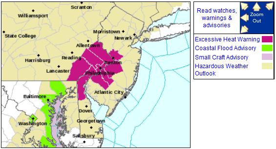
Excessive Heat Warning. The NWS has issued heat
warnings for the Delaware Valley, where the combination of heat and
humidity may result in a heat index as high as 110 F. by Thursday.
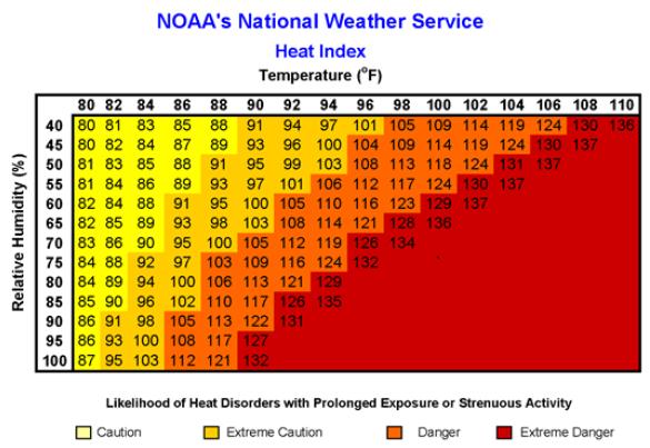
Heat Index. When there is a lot of water in the air,
like there will be today with dew points in the 70s, your body can't
cool itself naturally by evaporating sweat off your skin. There is less
"evaporative cooling", and it's much easier to overheat. The risk of
heat exhaustion and even heat stroke will be significant in the coming
days.
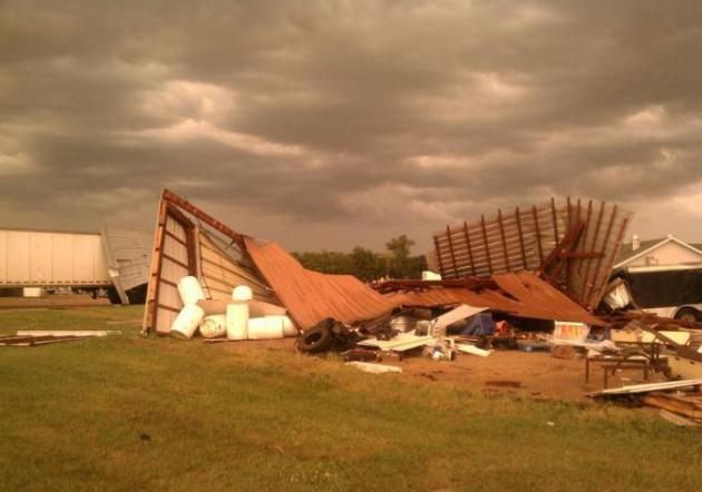
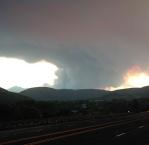
Tornado Damage In Ortonville. The photo above comes courtesy of The Ortonville Independent, via
Facebook: "
Ortonville hit by storm. Main St (2nd) is a mess."
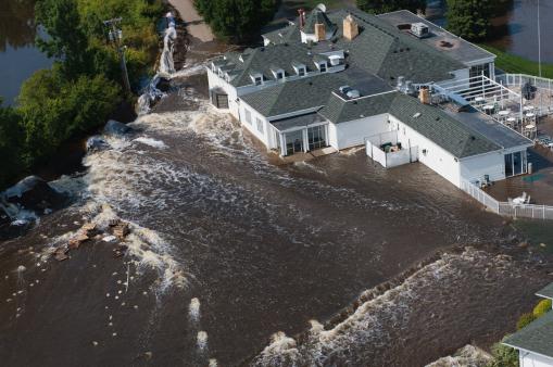
Minot Still Recovering A Year After Historic Flood. Details from AP and
The Dickinson Press: "
Events
are planned this weekend to celebrate Minot's recovery from the
historic Souris River flooding a year ago _ a rebound that North
Dakota's fourth-largest city is far from completing. The "Weekend of
Hope: Return to Oak Park" events will be highlighted by the reopening
of the area's largest park on Friday. Other family oriented events are
planned for Saturday. Mayor Curt Zimbelman said in a statement that it
is a time to remember how far the community has come in the past year.
"And since we still have a long way to go, we will rededicate ourselves
to do whatever it takes to continue restoring the hope needed for our
city and valley to rebuild from the 2011 flood," he said." (AP Photo/The Grand Forks Herald, Christian Randolph, File)
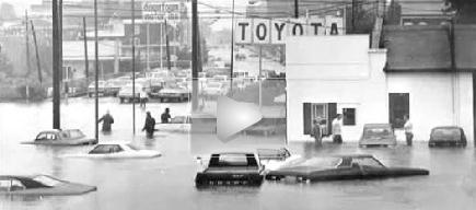
40 Years Ago Hurricane Agness Flooding Devastated Area.
This is the storm (Tropical Storm Agnes) that ultimately got me
interested in meteorology. Ask most TV meteorologists and they'll
probably confide that some sort of storm (flood, hurricane, tornado,
blizzard) put the fear of God in them, and got them started on a
meteorology path. Here's an excerpt (and video clip) from Norristown,
PA
The Times-Herald: "
The
Pottstown Mercury’s headlines in late June 1972 were as dramatic as
they come in the newspaper business." Words like “devastate,”
“critical,” “massive,” and “destruction” were bolded across the paper’s
top. As a reader goes through the pages, day by day, the headlines
don’t get much better. “Industry in Pottstown Crippled by Schuylkill” --
June 23."
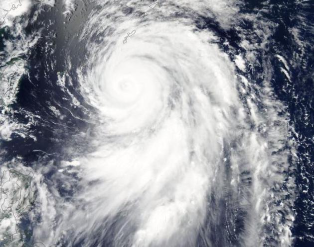
Typhoon Guchol. Here's the latest on Typhoon (same
thing as a hurricane) "Guchol", threatening coastal Japan, courtesy of
the University of Wisconsin
CIMSS: "
Here's a MODIS image of Typhoon Guchol heading toward Japan & forecast to make landfall Tuesday."
A Wider View. Here's another view of Typhoon Guchol from
Digital Typhoon, threatening southern Japan with a direct strike later today.
Hurricane Season Is Here: Are You Prepared? Some good information and advice in this article from
riverheadlocal.com; here's an excerpt: "
Advance
planning is the key to survival, he said. “Have a plan,” he cautioned.
There are many planning resources, including Riverhead Town's emergency preparedness webpage, the NOAA website, the Red Cross Hurricane Safety Checklist, and Suffolk County.
Dickman's top two suggestions: get familiar with the hazards in your
area, such as storm surge, flooding, and downed trees; and consider
evacuation/sheltering well in advance of the storm’s arrival. “Know
where nearby shelters may be located and plan your evacuation routes.
Leave plenty of time to get away,” he said, warning that the day before
the storm may be too late."
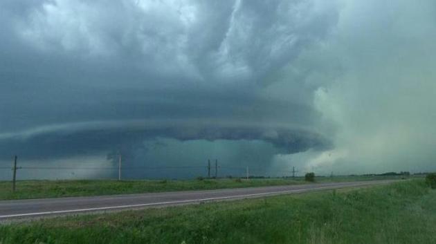
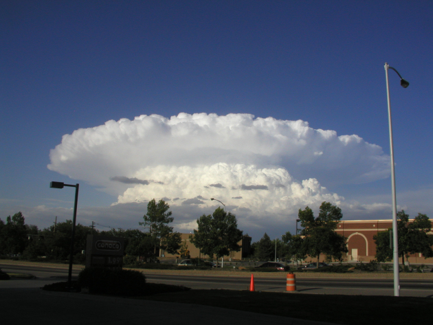
Photo Of The Day: "Supercell". Thanks to Jackie Noshea - who's sister sent in this remarkable photo from Herman, Minnesota Sunday afternoon.
Read more here: http://www.kansascity.com/2012/06/17/3656324/commentary-add-rising-sea-levels.html#storylink=cpy
"Ask Paul". Weather-related Q&A:
"Hello!
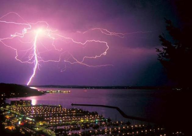
I was wondering about the lightning (Sunday) night that I noted
in the east-southeast skies, if it was lightning. I woke up and could
not figure out what the flashing lights were. When I looked outside it
appeared to be lightning of some type, but it was not like any type of
lightning I have seen before. I haven't heard anything on the weather
reports about it so I thought you might be able to help.
Thanks!"
Jan Rigsby
New Mexico Wildfire Threatens Smokey The Bear's Home. Details from
USA Today: "
One
of the serious forest fires in New Mexico is in the area where the
legendary Smokey the Bear was found as a cub. The "Little Bear" fire is
burning in the Smokey the Bear Ranger District, White Mountain
Wilderness and Lincoln National Forest
in southern New Mexico near Ruidoso. The forest is where the scared
bear cub was rescued in 1950. He went on to become the symbol of the
U.S. Forest Service, with an animated version growling, "Only YOU can
prevent forest fires!" in public service announcements."
Little Bear Fire Operations Brief On Chronology And Tactics. If you're tracking the western fires, check out this
Vimeo video update: "
Joe
Reinarz's Type 1 Southwest Incident Management Team, Operations Chief,
Carl Schwope details the chronology of the Little Bear Fire in New
Mexico that started on June 4, 2012. Schwope explains the tactics used
by the team to manage the fire when they arrived on June 9th."
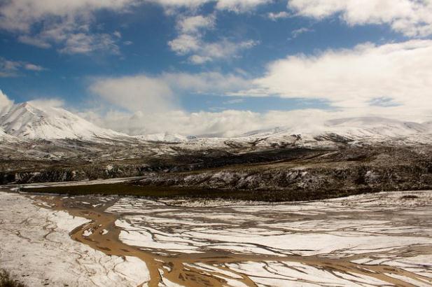
In Search Of Summer. Yes, summer comes only reluctantly to Denali National Park and Preserve; as explained in this
Facebook post: "
The June hours. Sometimes bring spring flowers. Sometimes snow showers." ~NH
Pssst...You Wanna Buy A Jet-Powered Go Kart? I know I do - details from
gizmag.com: "
Seth
Kettleman is no stranger to high-powered vehicles. The surplus
aircraft parts dealer provided the Boeing engine and technical support
for the building of a jet-powered Batmobile replica, and more recently attempted to sell his own similarly-outfitted Datsun 280ZX on eBay. Now, you have the chance to buy another one of his monstrosities – a custom-built jet-powered go-kart."
Hot Dog. Thanks to the BAMS Chase Team for sharing this photo via
Facebook: "
Even Guinness knows how to keep cool on these 90° days! A. #StayHydrated #HotDog #INwx."
Enough To Turn You Into A Vegetarian. Whoever wrote this headline needs a time-out.
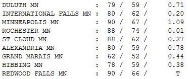
Steamy Monday. After a night of wild thunderstorms
and nearly continuous lightning, the sun was out most of the day Monday;
highs ranged from 62 at Grand Marais to 79 Duluth, 88 St. Cloud, and 90
in the Twin Cities and Redwood Falls.
Extended Outlook: Steamy Tuesday, Then More Comfortable.
The latest ECMWF (European) model is predicting a nice cool-down by
midweek, a welcome drop in humidity by Thursday. It's early, but right
now Saturday appears to be the wetter day of the weekend with scattered
showers and T-storms. Sunday appears to be the better day for the lake.
Paul's Conservation Minnesota Outlook for the Twin Cities and all of Minnesota:
TODAY: Stinking hot. Few T-storms likely, some severe. Dew point: 72. Winds: S 20. High: 94
TUESDAY NIGHT: More T-storms (best chance up north). Low: 65
WEDNESDAY: Much cooler with showers, possible thunder. Dew point: 65. High: 72
THURSDAY: Sunny, less humid. Dew point: 56. Low: 62. High: 81
FRIDAY: Fading sun, storms at night. Dew point: 61. Low: 64. High: 84
SATURDAY: Stormy start, slow PM clearing. Winds: NE 10. Low: 67. High: 78
SUNDAY: Sunnier, nicer day of the weekend. Dew point: 58. Low: 65. High: 81
MONDAY: Hazy sun, turning sticky again. Low: 66. High: 84
Showery Headaches
I want to apologize for Sunday's forecast. It
was a real stinker. "I thought you said it would be a nice day" my wife
helpfully reminded me. People are always thoughtful enough to point out
when we "bust" a forecast, especially on summer weekends.
"What time will it rain at my house Paul?"
Easy enough question. In fall, winter and spring
precipitation is "stratiform", big smears of steady rain or snow. But
in summer precipitation is "convective", showery, hit or miss. T-storms
are 5-10 miles wide, lasting 30-45 minutes. Computer models are pretty
useless until you get within about 12 hours of an event. All we can do
is tell when the atmosphere is RIPE for storms.
And every now and then (like Sunday) a cluster
of storms slips through the cracks altogether. It's a humbling
profession, but I try to admit when I'm wrong.
Sorry honey.
90s are likely today, strong storms up north. An
eastbound cool front ignites a few severe storms Wednesday, followed by
more comfortable air the latter half of the week.
Blast-furnace heat stays just to our south next
weekend; another round of T-storms Saturday AM giving way to a sunny,
comfortable Sunday. I pray.
Hey, it's June. Lower your expectations.
Climate Stories...
15 Military Leaders Say Climate Change Is A National Security Threat. Here's an excerpt of a story from Media Matters for America and
EcoWatch: "
Republicans in Congress are attempting to prevent the military from purchasing alternative fuels, which Senator Inhofe (R-OK) believes are merely “perpetrating President Obama’s global warming fantasies and his war on affordable energy.” And conservative media arebackingtheattacks
on climate change and clean energy programs, suggesting that these
investments come at the expense of national security. But experts across
the political spectrum agree
that climate change poses a serious threat to our national security,
and that transitioning to alternative energy will enhance military
effectiveness. Here are 15 current and former national security
officials in their own words on the threat of climate change: Thomas Fingar,
former chairman of President Bush’s National Intelligence Council: “We
judge global climate change will have wide-ranging implications for
U.S. national security interests over the next 20 years."
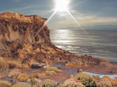
Ancient Climate Change Greened Antarctica.
Planet Save has the story; here's an excerpt: "
Ancient
Antarctica was much warmer and wetter than was previously thought,
according to a new study just released in the journal Nature Geoscience.
The climate supported lush vegetation, including stunted trees, along
Antarctica’s coastline. The research was done by the University of
Southern California."
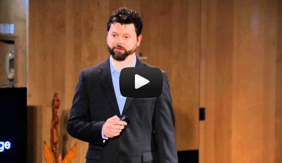
Climate Change Is Simple: We Do Something Or We're Screwed (My TEDx Video). Here's an excerpt of a great climate change overview and video from David Roberts at
Grist.com: "
Back in April, The Evergreen State College invited me to speak at a TEDx event called “Hello Climate Change: Rethinking the Unthinkable.” Videos from the event are now online. My talk was called “Climate change is simple.”
I’m proud to say that I used only 17 of my allotted 15 minutes. I’ve
put an annotated version of my slideshow beneath the video, linking to
sources and adding thoughts. The only thing I’ll say about the video
itself is that I’ve always thought these things would be better with a
soundtrack. If anybody out there on the web wants to make a mashup with
it, add some good beats, be my guest."
Stop Public Handouts To Oil, Gas And Coal Companies Now. Here's an excerpt of an Op-Ed from Robert Redford at
Huffington Post: "
Every year, around the world, almost one trillion dollars
of subsidies is handed out to help the fossil fuel industry. Who came
up with the crazy idea that the fossil fuel industry deserves our
hard-earned money, no less in economic times of such harsh human
consequence? We fire teachers, police and firemen in drastic budget cuts
and yet, the fossil fuel industry can laugh all the way to the bank on
our dime? Something doesn't add up here. We should not be subsidizing
the destruction of our planet. Fossil fuels are literally cooking our
planet, polluting our air and draining our wallets. Why should we
continue to reward companies to do that?"
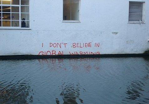
Commentary: Add Rising Sea Levels To List Of Banned Terms.
Now some state officials are banning the terms: "sea level rise" and
"climate change". Really? There are some forward-thinking "leaders".
More in an Op-Ed from the Miami Herald, reposted at
KansasCity.com: "
It
must be frustrating for our guys in Tallahassee. The governor and the
legislative leadership have made it plenty clear that they have no use
for this global warming stuff. Yet climate scientists keep dumping
water on Florida’s future. The latest damper comes from Climate
Central, which just published two papers in the peer-reviewed journal
Environmental Research Letters, warning that due to global warming and
rising sea levels, 3.7 million Americans reside in areas with an
escalating risk of storm surge and coastal flooding. Half of them are in
Florida. South Florida comes out looking particularly soggy."
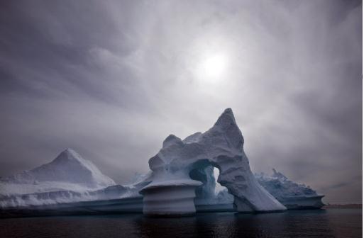
European Arctic Forest Expansion Could Result In Carbon Dioxide Release: Study. Here's an excerpt from a story at
phys.org: "
The Arctic is getting greener as plant growth
increases in response to a warmer climate. This greater plant growth
means more carbon is stored in the increasing biomass, so it was
previously thought the greening would result in more carbon dioxide
being taken up from the atmosphere, thus helping to reduce the rate of
global warming. However, research published in Nature Climate Change,
shows that, by stimulating decomposition rates in soils, the expansion
of forest into tundra in arctic Sweden could result in the release of
carbon dioxide to the atmosphere." (AP Photo/John McConnico, File).









No comments:
Post a Comment