93 F. high yesterday in the Twin Cities, tying for the hottest day of the year, so far.
82 F. average high for June 27.
77 F. high on June 27, 2011.
100 F. at several mesonet stations in the Mankato area Wednesday.
99 F. at New Ulm yesterday.
97 F. reported at St. James.
* no, it didn't get quite as hot as I thought it might yesterday. A
strong south/southwest wind never developed (favored for hottest
temperatures). Patchy clouds and high dew points may have also prevented
the mercury from climbing above 93 F. in the metro. Soil moisture
levels are high - some of the sun's energy went into evaporation instead
of heating up the air near the ground. Caveats and lame excuses aside,
it was hot enough for most folks.
Dew Point Prediction:
58 F. Today
61 F. Friday
66 F. Saturday
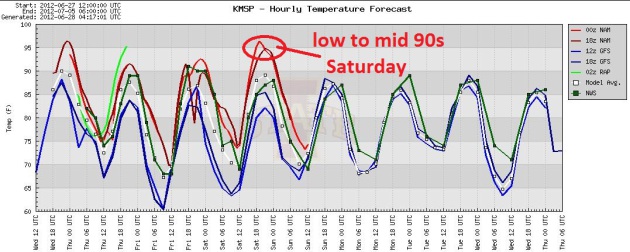
Hot Streak. We'll come close to 90 today (upper 80s
with a welcome dip in dew point). Every day from Friday through the end
of next week the ECMWF (European) model has MSP at or above 90, with a
chance of mid to upper 90s just in time for the 4th of July. 100
degrees? Not out of the question somewhere close to home by the middle
of next week.
So How Warm Was It Wednesday? Here's a post from the local Twin Cities National Weather Service: "
The
afternoon of the 27th saw the immense heat that had been building the
past several days to our southwest show up in a big way across southern
Minnesota in particular. The warmest observed reading at an airport
today was 99 at New Ulm, though a couple of 100 degree readings were
observed at mesonet stations in the Mankato area. Widespread 100 degree
highs were observed across Kansas up into the Omaha area, with highs
greater than 90 working up to about the I-94 corridor. The worst of the
heat has by far been observed in western Kansas, where Hill City saw
their second day in a row with a 115 degree high, and 5th day in a row
with highs greater than 110. We will see a small respite from the heat
through this weekend, but extended forecasts sow the warm dome of high
pressure returning next week into the following week, with the first two
weeks of July looking to get off on a rather toasty note across the
Northern Plains into the Upper Mississippi River Valley."
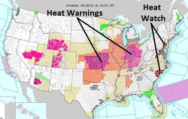
Heat Wave. NOAA's national
watch/warning map
shows Excessive Heat Warnings from the Central Plains into the Ohio
Valley, Excessive Heat Watches from the Delaware Valley and Washington
D.C. south to Wilmington, North Carolina.
Flirting With 90. We'll come close to 90 today, a
better chance of topping 90 Friday, low 90s likely Saturday. The U.S.
models have been (consistently) underestimating the warmth in recent
weeks - I still think the ECMWF has a better grasp on the
scope/intensity of the upcoming heat.
"
1 in 4 Colorado homes lies in a fire risk zone, and 100,000 people have moved into those zones in the last decade"
"
When you have Mother Nature in that kind of situation with those
3 factors that affect fire behavior: fuels, topography and weather,
when those three are in alignment, there's nothing anyone can do." - from the PBS News Hour Wednesday evening.
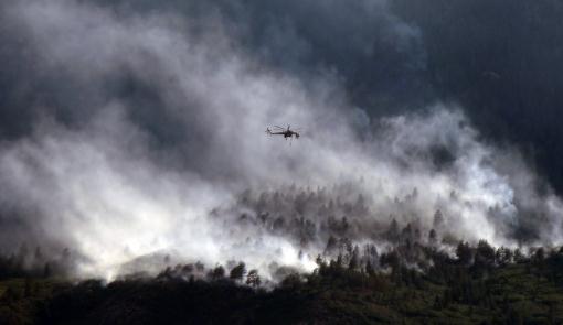
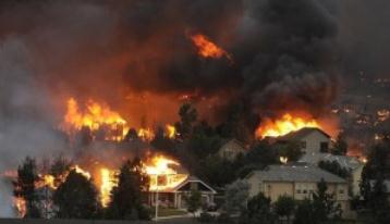
Photo credit above: "
A helicopters flies over as the Waldo
Canyon Fire continues to burn Wednesday, June 27, 2012, in Colorado
Springs, Colo. The wildfire doubled in size overnight to about 24
square miles (62 square kilometers), and has so far forced mandatory
evacuations for more than 32,000 residents." (AP Photo/Bryan Oller)
"
Between June 19-25, there were 14 all-time high temperature
records set or tied, along with two all-time overnight warm low
temperature records. There were no all-time cold temperature records
set or tied during the same period. In a long-term trend that
demonstrates the effects of a warming climate, daily record-high
temperatures have recently been outpacing daily record-lows by an
average of 2-to-1, and this imbalance is expected to grow as the
climate continues to warm." - from a post at Climate Central; details below.
“
As a species that’s why we’re all still here: we have spent our
entire existence adapting. So we will adapt to this,” he said. “It’s an
engineering problem, and it has engineering solutions.” - Exxon CEO Rex Tillerson, from a Think Progress story; details below.
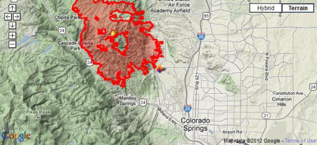
Colorado Wildfire Of "Epic Proporations" Displaces 32,000; Tests Firefighters.
CNN has a comprehensive report; here's an excerpt: "
Firefighters
again will battle inferno-like conditions on Wednesday as they try to
tame an explosive wildfire that has already chased some 32,000
residents from their homes near Colorado Springs, Colorado. "This is a
firestorm of epic proportions," Richard Brown, the Colorado Springs
Fire chief, said late Tuesday. Winds gusting to 65 mph through mountain
canyons blew the wildfire through containment lines into northwest
Colorado Springs on Tuesday afternoon. Gov. John Hickenlooper surveyed
the Waldo Canyon Fire, telling reporters it was a difficult sight to
see. "There were people's homes burned to the ground. It was surreal,"
he said late Tuesday night. "There's no question, it's serious. It's as
serious as it gets."
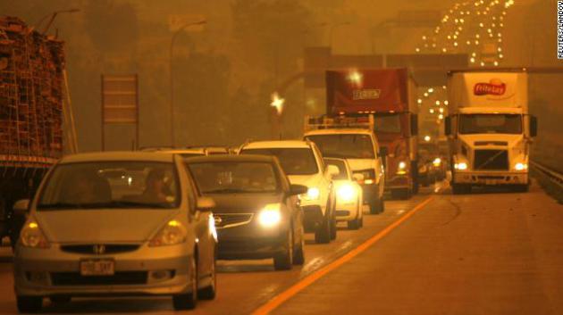
Photo credit
above: "Smoke from the Waldo Canyon Fire engulfs Interstate 25 north
of Colorado Springs, Colorado, as the blaze burns out of control
Tuesday, June 26. The 6,200-acre Waldo Canyon Fire has caused 32,000
residents to be evacuated. At least six other fires are active in
Colorado." Photo: Reuters.
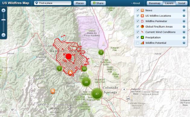
Tracking The Colorado Springs "Waldo Canyon" Blaze. Over 15,000 acres have already burned, over 30,000 residents of Colorado Springs impacted by the largest fire in memory.
The Denver Post
has a terrific interactive map that integrates Google Maps with layers
of data, including social media, photos, YouTube clips, etc - for a
comprehensive look at the fire status.
Inciweb. There is a wealth of additional information about evacuation orders and additional links at
inciweb.org, where you can find more information on every active fire in the USA.
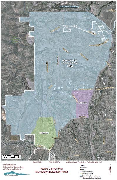
Colorado Springs Mandatory Evacuation Area. Here is a
map
showing where people have to get out - staying isn't optional - as far
east as Interstate 25, as far south as Highway 24, courtesy of
springsgov.com.
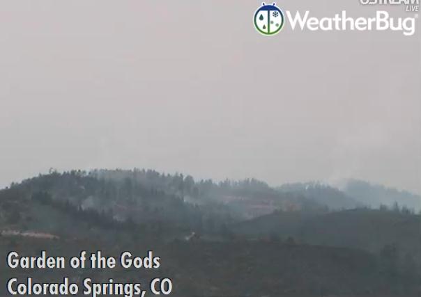
Live Webcam: Garden Of The Gods, Colorado Springs. On
WeatherBug webcams you can see smoke, and occasionally flames from the wildfires burning around Colorado Springs - a harrowing sight.
Heatwave Bakes The Plains And Midwest, Moves East.
My friend and fellow meteorologist Andrew Freedman has a good overview
of the latest heat-bubble plaguing the USA in this post from
Climate Central; here's an excerpt: "
A
prolonged and historic heat wave is baking the West and migrating
eastward, with temperatures from Texas to Chicago expected to approach
or exceed 100°F during the next few days. Already, several all-time high
temperature records have been set. On June 25 and 26, Denver
tied its all-time record high temperature for any month of the year
when the thermometer at Denver International Airport hit 105°F. That
was an all-time high temperature record for June as well, and marked
five straight days of 100 degree plus heat, which ties another record."
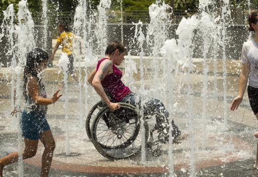
Photo credit above: "
Tanya Winters cools off in a fountain
at Butler Park in Austin, Texas, on Tuesday June 26, 2012. Tuesday's
high temperature of 109 was the highest ever recorded in June in Austin." (Jay Janner/Austin American-Statesman/MC
T)
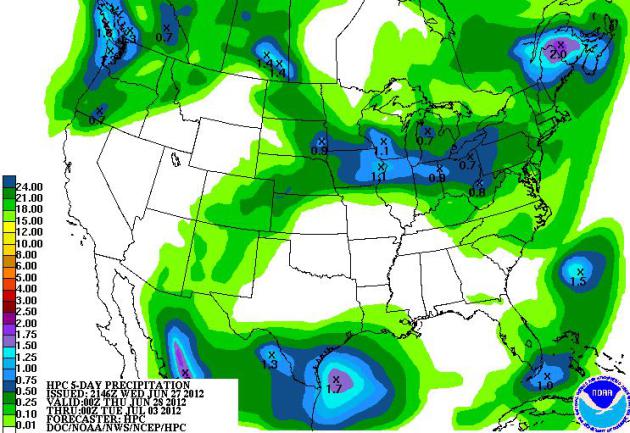
5-Day Outlook. Florida finally dries out, after some
unofficial 30" amounts near Tallahassee. A few T-storms rumble across
the Midwest, more rain (and unusually cool weather) for the Pacific
Northwest. QPF map courtesy of NOAA.
Debby Aftermath: Flooded Homes, Busted Roads.
MSNBC.com has a good summary of the havoc triggered by "Debby"; here's an excerpt: "
Tropical
Depression Debby moved off into the Atlantic on Wednesday, as many
Florida communities started the long process of drying out and cleaning
up. Flooding damaged thousands of homes, washed out roads, opened up
sinkholes and closed a section of Interstate 10 — the state's main
east-west highway. In the Tampa area, more than 20 sinkholes opened up
from the flash flooding, Tampa Bay Online reported.
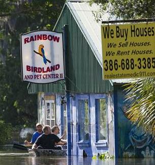
Water was up to the roofs at some homes in low lying areas of Live
Oak, Fla., on Wednesday. Several feet of water remained around
businesses in downtown near the courthouse and many roads were
impassable."
Photo credit above:
Dave Martin/AP. "A flooded business in Live Oak, Fla., is inspected from the outside on Wednesday."
Tropical Storm Debby: How A Deadly Storm Got Such A Cute Name. Some interesting weather nuggets in a story from
The Los Angeles Times; here's an excerpt: "
The
labeling and naming of hurricanes is a long-held practice that helps
ease communication and tracking -- especially when two or more tropical
storms occur at the same time, according to the National Oceanic and Atmospheric Administration.
It's more art than science, however, and can be fraught with
controversy. Still, there is something about Debby -- perhaps it's the
perky y at the end, reminiscent of a pigtailed schoolgirl practicing
penmanship -- that strikes many as being particularly ill-suited for a
deadly storm."
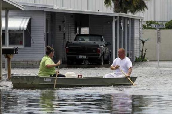
Photo credit above: "
Residents of the Suncoast Gateway
Mobile Village in New Port Richey, Fla., leave in a rowboat as Tropical
Storm Debby sends floodwaters in."
(Associated Press / John Raoux / June 26, 2012)
NASA Measuring Tropical Storm Debby's Heavy Rains From Space. Here's an except of a very interesting story from
phys.org - a new generation of low-orbiting satellites can derive rainfall rates (and total amounts) from space: "
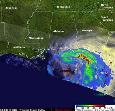
The
Tropical Rainfall Measuring Mission (or TRMM) satellite captured an
image of Debby when it passed over the storm in the north central Gulf
of Mexico on the morning of June 24 at 11:51 UTC (6:51 a.m. CDT). TRMM
revealed that most of the rain associated with Debby is well away from
the center. A large area of moderate rain north and east of the center
extends from near Tampa Bay all the way around to near Panama City. A
large band of intense rain lay just off shore, while light to moderate
rain covered a broad area of the Florida peninsula.
How Rainfall is Mapped:
Data from several TRMM instruments are used to create rainfall
images at NASA's Goddard Space Flight Center in Greenbelt, Md. Rain
rates in the center of image swaths are from the TRMM Precipitation
Radar (PR), while those in the outer swaths are from the TRMM Microwave
Imager (TMI). The rain rates are then overlaid on infrared (IR) and
visible data from the TRMM Visible Infrared Scanner (VIRS). TRMM is a
joint mission between NASA and the Japanese space agency JAXA."
Image credit above: "
In this image of rainfall on June 24,
2012, created by NASA's TRMM satellite, a large band of intense rain
(darker red) lies just off Florida's western shore, while light (blue
areas) to moderate rain covers a broad area of the Florida peninsula.
Moderate rain (shown in green) north and east of the center extends
from near Tampa Bay all the way around to near Panama City. Tornado
symbols mark the locations of tornado reports." Credit: SSAI/NASA, Hal Pierce
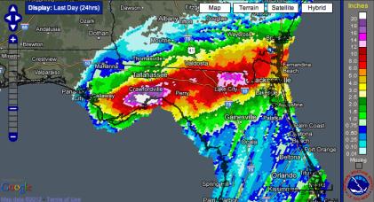
Tropical Storm Debby Floods Florida, Ends Drought. There is one (big) silver lining - the drought in Florida is history, as reported by
Climate Central; here's a snippet of the article: "
By following a slow and erratic path in the northeastern Gulf of Mexico, Tropical Storm Debby
has dumped extraordinary amounts of rain on the Sunshine State, with
many locations receiving at least 6 inches of rainfall — and the rain is
still falling. Wind shear has kept the most active part of the storm
on its eastern flank – directly on top of Florida. For example, as of
June 25, Tarpon Springs had already received 21.04 inches of rain
during June, eclipsing the record for the wettest June by nearly 3
inches. It has also been the wettest June in Tampa since records began
there in 1890, according to the National Weather Service."
Graphic credit above: "
24-hour precipitation totals between June 25 and June 26 across northern Florida. Click on the image for a larger version." Credit: NOAA/NWS.
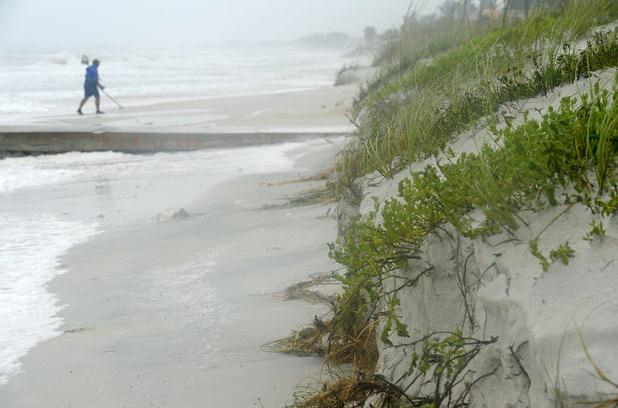
Tropical Storm A Reminder To Protect Our Vital Interests. This applies to all weather phenomena, including tornadoes and floods, not just Hurricane Alley. Some good advice from
The Bradenton Herald; here's an excerpt: "
While
emergency management officials have yet to assess all the damage to
beaches, homes and infrastructure, Gov. Rick Scott quickly declared a
state of emergency. With all the water and wind damage to structures,
insurance adjustors are already out on the streets inspecting damaged
roofs and flooded vehicles and homes. While auto and flood insurance
will cover much of the damage, roofs ripped apart by winds are the
province of property policies. And Florida's property insurance market
remains rocky. The state-run insurer of last resort, Citizens Insurance
Corp., holds $500 billion in risk exposure but only holds a $6 billion
cash surplus and could cover storm damage amounting to $20 billion
with its reinsurance policies and bond capacity making up the
difference."
Storm Chasers Head To Saskatchewan. Have you noticed
that "Tornado Alley" is shifting north over time? I don't recall
professional storm chasers heading into Canada 15-20 years ago. As the
climate warms and weather patterns shift north, for much of the summer
the biggest temperature gradients (and resulting atmospheric clashes)
will be north of the U.S. Canada border. Here's an excerpt of an
interesting article at
The Calgary Herald: "
A
storm chaser says he and others from the southern United States are
going to be watching the skies in southern Saskatchewan. Greg Johnson
says on his blog that - quote - "Tuesday is looking scary in
Saskatchewan." He says forecast models show that severe weather is
imminent and the risks include large hail, damaging winds, and strong
tornadoes. Johnson says he will be in an area north and slightly east
of Moose Jaw Tuesday looking for tornadoes and storms, adding the
potential is so great that fellow storm chasers from the southern
United States are converging on the Regina area with the expectation
they'll see some activity."
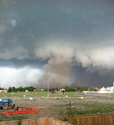
Photo credit above: "
Dust is kicked up as a possible
tornado touches down in Taber, Alberta on Tuesday June 5, 2012. A strong
storm cell moving north out of Montana triggered several tornado
warnings and watches between Coaldale and Taber." (AP Photo/Shannon Reynolds, The Canadian Press)
El Nino Comeback, Hurricane Setback? If we are, in
fact, heading into another El Nino warming phase of the Pacific, winds
over the tropics tend to be stronger, shredding developing tropical
cyclones, in some cases preventing them from maturing into full-blown
hurricanes. Tony Wood at
philly.com has an interesting post; here's an excerpt: "
This
morning, WSI Corp., the commercial weather service in Massachusetts,
tweaked its hurricane outlook in light of two very different
developments. First, since the season is off to a frisky start, with
four tropical storms worthy of a name, the company bumped up the
forecast for named storms from 11, to 12. More significantly, WSI now
believes the season will be losing steam at a critical time, in
September and October, when storms born off the African coast can crash
into the U.S. East Coast. WSI meteorologist Todd Crawford banks the
late-season outlook on the development of abnormally warm waters in the
tropical Pacific, or El Nino, later in the summer. During El Nino, the
heating of the overlying air ultimately results in strong upper-level
winds from the west that can shear off incipient tropical storms in
the Atlantic Basin before they can build into hurricanes."
"Ask Paul". Weather-related Q&A:
"
Dear Paul - I truly appreciate your efforts to raise awareness
about climate change. This is a hugely important issue that,
unfortunately, is not covered enough by journalists. Do you have any
advice for people who would like to get involved (beyond lowering their
own carbon footprint) but are unsure how to do so?"
Thanks,
Peter Groynom, Minneapolis
Peter - thanks for your note, and a thoughtful question. It can be an
overwhelming topic to consider. How can one person make a difference?
By setting an example, by making a series of small changes in your
behavior that just might, over time, rub off on friends and family
members. You're right about taking steps to lower your carbon footprint:
consider buying a more fuel efficient vehicle, make sure your home is
well insulated and operating at peak efficiency. The most important
thing you can do as a citizen? Make sure your elected officials know
that this is an important subject to you. Politicians respond to public
opinion and a (loud) and passionate electorate. I asked a few climate
scientists for their suggestions; here is a small sampling of what they
said:
"
Coordinated collective action is the only way to get out of this
mess. Small individual actions are feel-good Band-aids that wealthiest,
international-traveling, beef-eating,
more-than-replacement-level-children-having, exurb-living, SUV-driving,
McMansion-inhabiting, motorized-recreation-loving, big-box-shopping,
drive-through-fast-food-buying, single-occupant-vehicle-commuting,
kid-schlepping Americans do to feel good about themselves.
If you do all that, it doesn't matter if you use paper or plastic (or recycled bags).
There has to be a fundamental change in the way we do things. The
price of fossil fuels MUST include the cost of externalities associated
with the loss of environmental services. These services are a
fundamental property rights, and cannot be taken without just
compensation. That's how we need to pitch it from now on. Carbon dumping
fee with dividend to those whose property rights are being taken is the
only way out."
- Mark Boslough
"
A while ago someone (McKibben?) said that in order to minimize
our carbon footprint we need to maximize our political footprint, a
formulation I like very much.
I tell people that as far as their personal
consumption, the biggest, lowest hanging fruit are their electricity
supply (I live in a place where one can pick; I pay about one cent more
per kWh for 100% green electrons), transportation, and the embedded
energy/carbon/water impacts of the finished goods they consume. Sadly,
all of this gets into things people REALLY don't want to hear, like the
footprints of beef or running their swimming pool heater or driving
their kids all over creation in their Belchfire 9000 SUV, which tends to
end the conversation very quickly." - Lou Grinzo
"If you have decided that climate change is
something that we need to address, then you may be wondering what you as
an individual can do.
There certainly are personal choices you can make that will reduce your share of emissions of greenhouse gases. Some
of these choices will not only reduce emissions, but also save you
money and benefit you in other ways (e.g., get exercise by walking a
mile to a friend’s house instead of driving). Other choices may require
upfront costs, but will pay for themselves over subsequent years (e.g.,
add insulation to your attic or switch to LED lighting). Some choices
are difficult to justify on economic grounds alone (e.g., install
photovoltaic solar panels on your house). But
voluntary individual action is unlikely to motivate the emissions
reductions necessary to stabilize the climate. Such reductions will
require collective, coordinated action by society as a whole. That’s why
the single most important thing you can do is vote for politicians who
support action on climate. Even better would be to become politically
active – write letters to your representatives, participate in rallies,
talk to your friends and neighbors." - Andrew Dessler
"I really think the most important thing is
to make their concern known to their elected officials, whether they
voted for them or not." - Tenney Naumer
"
Join 350.org and ForecastTheFacts.org. And participate in the campaigns." - Brad Johnson
"One might also consider becoming a Climate Reality Group community speaker." - Scott Mandia
“Let’s be clear:
global warming is much greater in scope than a burning river and more
complex than a hole in the ozone layer. But…people caused the problem,
and people can solve it. We already have many of the tools and
technologies we need to address global warming. The key is for each of
us to begin to work toward solutions.”
- Aaron Huertas, who authored a terrific book with suggestions on what we can all do to help
Here is an overview of the book - you can get a pdf sample
here:
"
As we try to live a climate-friendly life, we face a seemingly
endless series of decisions: what to drive, what to wear, what to eat,
what technologies to use. Meanwhile, we're bombarded with often
conflicting messages from advertisers and the media about what products
and lifestyle choices can lower our carbon footprint. What we really
need is a reliable source of practical, science-based advice to help us make smart choices about the things that matter most. And now we have it. Based on an in-depth, two-year study, Cooler Smarter: Practical Steps for Low-Carbon Living
(May 2012, Island Press) shows you the most effective strategies for
reducing your global warming emissions, and how to take action at work,
in your community, and politically."
9 Beliefs Of Remarkably Successful People. Here's a snippet of an article at
Inc.com that caught my eye: "
I'm
fortunate enough to know a number of remarkably successful people.
Regardless of industry or profession, they all share the same
perspectives and beliefs. And they acto on those beliefs:
1). Time doesn't fill me. I fill time.
Deadlines and time frames establish parameters, but typically not
in a good way. The average person who is given 2 weeks to complete a
task will instinctively adjust his effort so it actually takes 2 weeks.
Forget deadlines, at least as a away to manage your activity. Tasks
should only take as long as they need to take. Do everything as quickly
and effectively as you can. Then use your "free" time to get other
things done just as quickly and effectively."
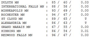
A Taste Of What's To Come. It was the 8th day at or
above 90 so far in 2012 in the Twin Cities. A trace of rain fell at
Alexandria and St. Cloud, highs ranging from 67 at Grand Marais to 89
St. Cloud, 93 Twin Cities, 94 at Rochester and 96 at Redwood Falls.
Read more here: http://www.bradenton.com/2012/06/27/4092680/tropical-storm-a-reminder-to-protect.html#storylink=cpy
Read more here: http://www.bradenton.com/2012/06/27/4092680/tropical-storm-a-reminder-to-protect.html#storylink=cp
9 Beliefs Of Remarkably Successful People. Here's a snippet of an article at
Inc.com that caught my eye: "
I'm
fortunate enough to know a number of remarkably successful people.
Regardless of industry or profession, they all share the same
perspectives and beliefs. And they act on those beliefs:9 Beliefs Of Remarkably Successful People.
Here's a snippet of an article at Inc.com that caught my eye: "I'm
fortunate enough to know a number of remarkably successful people.
Regardless of industry or profession, they all share the same
perspectives and beliefs. And they act on those beliefs
Paul's Conservation Minnesota Outlook for the Twin Cities and all of Minnesota:
TODAY: Partly sunny, turning slightly less humid. Dew point: 63. Winds: N 10. High: 89
THURSDAY NIGHT: Partly cloudy skies. Low: 68
FRIDAY: Some sun, heating up. Dew point: 61. Winds: S 10. High: 92
SATURDAY: Sticky sun. A mix of clouds and sun. Dew point: 66. Winds: Northeast 8. Low: 71. High: 93
SATURDAY NIGHT: Muggy with a slight chance of a T-storm. Low: 70
SUNDAY: Stray T-storm, steamy sunshine. Dew point: 68. Winds: SW 7. High: 92
MONDAY: Plenty hot. Bright sun. Dew point: 70. Feels like 105. Low: 73. High: 93
TUESDAY: Triple-digit heat? We may come close in the metro. Storms pop up north. Low: 74. High: 97
4TH OF JULY: Stinking hot! Hazy, murky sun - still very muggy. Dew point: 71. Low: 72. High: 98
Partly Sweaty
At least Mother Nature is crazy-consistent.
Spring came early. Planting season came early. And now the Dog Days are
coming 2-3 weeks ahead of schedule. That's right, you can throw "normal"
right out the window.
A Guam-like weather pattern lingers into most of
next week as "waves" of suffocating heat surge north into Minnesota.
90s will be the rule, the ECMWF is hinting at 100-degree heat next week.
The lake beckons. An air conditioned store would work nicely, too.
Expect a slight dip in dew point today before we
heat up again over the weekend - the pattern not ripe for widespread
storms. It'll be too hot aloft.
Are you paying attention to the maps? 10" rains
swamp Duluth, unprecedented wildfire evacuations in Colorado Springs;
many cities setting all-time record highs? It's all consistent with a
warming atmosphere.
I worry that it may take a series of climate
calamities for Americans to wake up: a big western city burning down or
running out of water. Thousands succumbing to extreme heat. Too
alarmist? We'll see.
The trends ARE alarming. Some climate scientists are saying "I told you so."
Hunker down. Yesterday was just a taste. The main (100-degree) course arrives next week.
Climate Stories....
As Exxon CEO Calls Global Warming's Impacts "Manageable", Colorado Wildfires Shutter Climate Lab. Life is full of irony, and this story underscores just how "manageable" a warming atmosphere really is. Here's an excerpt from
Think Progress: "
Fueled by a warming climate,
Colorado is experiencing its worst fire season in its history. As
researchers at Boulder’s National Center for Atmospheric Research (NCAR)
joined 32,000 other Coloradans in fleeing the fires, ExxonMobil
CEO Rex Tillerson spoke to the Council on Foreign Relations about the
“manageable” risks of climate change: Rex Tillerson said at a meeting at
the Council on Foreign Relations in New York that climate change was a
“great challenge,” but it could be solved by adapting to risks such as
higher sea levels and changing conditions for agriculture."
Federal Appeals Court Upholds CO2 Rules. Andy Revkin at
The New York Times has the story - here's an excerpt: "
The United States Court of Appeals for the District of Columbia Circuit has bluntly rejected challenges to the Obama Administration’s rules
restricting carbon dioxide emissions as a pollutant under the Clean
Air Act. Here’s the core conclusion of the panel and the full ruling:
Following the Supreme Court’s decision in Massachusetts v. EPA, 549
U.S. 497 (2007)—which clarified that greenhouse gases are an “air
pollutant” subject to regulation under the Clean Air Act (CAA)—the
Environmental Protection Agency promulgated a series of greenhouse
gas-related rules. First, EPA issued an Endangerment Finding, in which
it determined that greenhouse gases may “reasonably be anticipated to
endanger public health or welfare.”
Court Decision Clears Way For Climate-Change Controls.
The Salt Lake Tribune has more on the implications of the recent EPA ruling; here's an excerpt: "
Cleaner
air and less of the pollution blamed for climate change will be among
the benefits Utahns and other Americans can expect as a result of a
federal appeals court ruling on Tuesday. That was the consensus of
environmental groups reacting to a U.S. Court of Appeals for the District of Columbia decision
to uphold the U.S. Environmental Protection Agency’s "endangerment"
finding, clean-car standards and pollution permit requirements for new
and expanding large industrial plants."
Energy And Climate Change In The Southwest: A Prologue. Another interesting post from the climate scientists at
Climate Central; here's a snippet: "
Last
year was the hottest and driest on record in Texas. There were 90 days
of 100-degree heat in Austin. The Texas drought of 2011 was the driest
12-month period on record, by a large margin. The state is just
beginning to emerge from under the deep red blotch that consumed it on
precipitation maps. 2011 was my first full year in Texas. But meanwhile
across the rest of the American Southwest, where I’ve spent most of my
life, other inauspicious records were being set. The Wallow Fire became
the biggest in Arizona’s history, burning 538,049 acres. New Mexico,
with my hometown of Santa Fe, experienced its biggest forest fire ever
just a few weeks ago."
More Evangelicals Fight Against Climate Change. Yes,
you can love the Lord and still respond to science, data, and facts on
the ground. Thank God there are people that still think like stewards
and understand, on some level, that actions have consequences. Here's an
excerpt of a recent press release in
The Vancouver Sun: "
The Evangelical Environmental Network (EEN) will be running TV spots in
key states asking viewers to tell their Senators “that defending the
EPA’s ability to reduce carbon pollution is the right thing to do.” On
Monday, May 25th, EEN’s President, the Rev. Mitch Hescox, will meet
with Environmental Protection Agency (EPA) Administrator Lisa Jackson,
play the TV spot for her, and hand-deliver more than 40,000 messages of
support from pro-life Christians. “We’re happy to stand side
by side with Administrator Jackson as the EPA leads our country in
reducing carbon pollution,” Hescox says. The TV spots highlight
the extreme weather that has been plaguing the United States and point
out that the poor in lesser developed nations are and will continue to
experience more frequent and intense heat waves, droughts, floods and
other harmful impacts due to climate change. “You do whatever
it takes to protect someone you love,” the video narrator says. “What
about the less fortunate in poorer countries? Climate change is
threatening their lives. Jesus taught us to care for ‘the least of
these,’ and today this means working to overcome climate change.”
Photo credit above: "
The Evangelical Environmental
Network's TV spots highlight the extreme weather that has been plaguing
the United States and point out that the poor in lesser developed
nations are and will continue to experience more frequent and intense
heat waves, droughts, floods and other harmful impacts due to climate
change."
Evangelicals And Climate Change: Global Warming Skeptics (Part 3). Here's an excerpt of an interesting story at
The Christian Post: "....
The
mainstream press for the better part of 20 years has given them equal
time when they didn't deserve it. When the arguments weren't really
compelling, the press has always been willing to say, 'well the other
side of the argument is ...' as if that side has equal weight to it."
What's an Evangelical to Do?
Though on opposite sides of the issue, Beisner and Cizik made
similar claims. They both agreed that atmospheric carbon causes the
Earth to get warmer. They both appealed to scientific evidence and
believe the evidence is on their side. And, they both displayed concern
for the poor and vulnerable. Perhaps the biggest difference between
them has to do with how they view the Earth – fragile or robust.
Beisner views the Earth as robust, able to handle the human-caused
changes to the atmosphere. Cizik believes the Earth is fragile and too
much human tinkering will have catastrophic effects."








No comments:
Post a Comment