82 F. high in the Twin Cities Tuesday.
82 F. average high for June 26.
79 F. high on June 26, 2011.
6. Today will be the 6th day this month of 90-degree heat, the
8th day in 2012 of 90+ readings.
76.9 F. predicted dew point at 7 pm this evening in the Twin Cities.
 Heat Advisory
 in effect for the metro.
Air Pollution Health Advisory in effect for the metro.
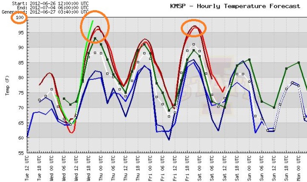 Hottest Day Yet?
I'm feeling a little better about going out on a limb and predicting
upper 90s later today. The 2 most recent NAM simulations show 97, the
RAP (rapid update) model is hinting at 100. High dew points may limit
how hot it gets today (our hottest days usually come on lower dew point
afternoons). But if the sun stays out and winds keep blowing from the
south/southwest we should see mid to upper 90s. A few towns just south
of MSP may sample 100 F.
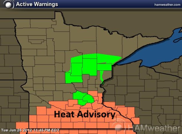 Heat Advisory.
 Here's the latest from the local NWS office:
A HEAT ADVISORY IS IN EFFECT FROM 1 PM TO 8 PM CDT ON WEDNESDAY
FOR MOST OF SOUTHERN MINNESOTA...THE TWIN CITIES METROPOLITAN
AREA AND PORTIONS OF WEST CENTRAL WISCONSIN. A MUCH WARMER AND
HUMID AIR MASS WILL MOVE INTO MINNESOTA WEDNESDAY MORNING. BY THE
AFTERNOON...THE COMBINATION OF HEAT AND HUMIDITY WILL CREATE HEAT
INDEX VALUES BETWEEN 100 AND 105 DEGREES. THE HEAT AND HUMIDITY
WILL INCREASE THE RISK FOR HEAT RELATED ILLNESSES.
 Heat Spike
.
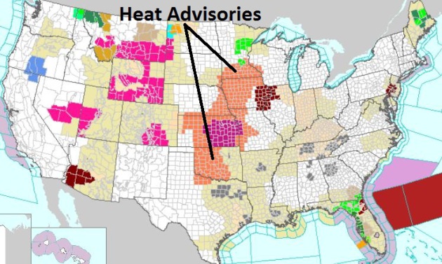
Heat Advisories are posted for much of America's midsection, an
Excessive Heat Watch for Kansas City and eastern Iowa/northwestern
Illinois. Air Stagnation Advisories (gray) are posted from Dallas to
Atlanta to Little Rock and Knoxville. Latest watches and warnings from
NOAA
here.
105 F.
at Denver Tuesday. That's two days in a row of 105 degree heat, both
days tying the all-time record for hottest weather ever recorded in The
Mile High City.
111 F. high at Miles City, Montana Tuesday - hottest temperature on record.
101 F. high at Colorado Springs Tuesday, the hottest temperature ever recorded. Previous record:
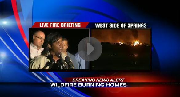
Major Evacuations In Colorado Springs. As of 10 pm
Tuesday evening an estimated 30,000 residents of Colorado Springs had
been evacuated in advance of raging wildfires. KKTV-TV has live coverage
of this major breaking news story
here.
Kids, Pets & Hot Cars = Tragedy. Here is an excerpt of a very timely story from Chuck Mai at
newsok.com in Oklahoma, where locals are accustomed to 100-degree heat (unlike Minnesotans): "
It’s
important to remember that temperatures inside a car on a day with
outside temperatures in the mid-to-high 90’s can quickly soar to nearly
200 degrees, which is hot enough to cook many foods and to kill most
living things. Never leave children or pets in a parked car. If you do
see a child or pet locked in a car and cannot find the owner of the
vehicle, call 911 immediately.
Child passenger summer safety tips:
• Never leave a child alone in a car – even with the windows
partially opened– as a vehicle’s interior can still heat up quickly to
deadly temperatures.
• Make a habit of looking in the vehicle – front and back – before
locking the door and walking away. Children have died because they fell
asleep in their car seats and their parents didn’t realize they were
still in the car.
• If your spouse or a guardian is taking your children to day care,
ask him or her to call you to make sure the drop-off went according to
plan."
Air Pollution Health Advisory. Here's the latest from
MPCA: "
The
Minnesota Pollution Control Agency (MPCA) has issued an air pollution
health advisory due to forecasted increases in ozone pollution for the
Twin Cities metropolitan area and Rochester effective from noon until
midnight on Wednesday, June 27.
At-Risk Populations: Ozone is expected to near a
level that is considered unhealthy for sensitive groups. Those
sensitive to ozone include people with preexisting respiratory
conditions, the elderly, children, and individuals who participate in
outdoor activities requiring extended or heavy exertion. These
individuals are encouraged to postpone or reduce vigorous outdoor
activity, or schedule outdoor activity in the morning, when ozone levels
are lower. Even persons who are otherwise healthy may experience health
effects when ozone levels increase.
Health Impacts: Elevated levels of ozone have
been linked with respiratory health effects. Exposure to high levels of
ozone may exacerbate preexisting health conditions. High ozone levels
may make it more difficult to breathe deeply and vigorously, cause
shortness of breath and breathing discomfort, and result in coughing and
a sore or scratchy throat. If you experience these symptoms, contact
your physician."
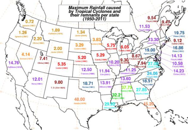
45.2" rain at Yankeetown, Florida from Hurricane
Easy in 1950, the record for most rain from a tropical cyclone in
Florida. Details below.
Hundred-Degree Highs In The Metro:
103 F. June 7, 2011
101 F. July 31, 2006
101 F. July 13, 1995
100 F. July 3, 1990
101 F. August 1, 1988
105 F. July 31, 1988
102 F. July 15, 1988
101 F. June 24, 1988
102 F. June 8, 1985
100 F. July 5, 1982
* thanks to Greg Spoden, Climatologist at the Minnesota DNR, for passing this along.
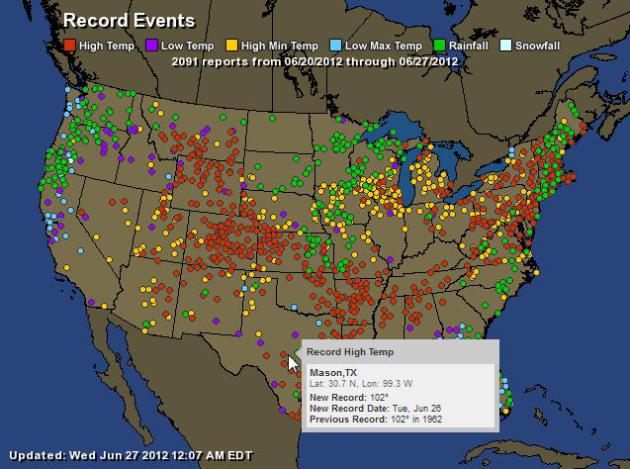 A Week's Worth Of Records
.
2,091 records in just the last week, record rains from the Pacific
Northwest to Duluth to New England, and a surge of record heat. Map
courtesy of NOAA and
Ham Weather.
“
We’re seeing these conditions 30 to 45 days earlier, as far as
the level of fuel and the low moisture,” he said. “We’ve seen the fire
season develop much earlier in Colorado than in the past.” - excerpt from a New York Times article on the rash of wildfires impacting the western USA. Photo: NOAA.
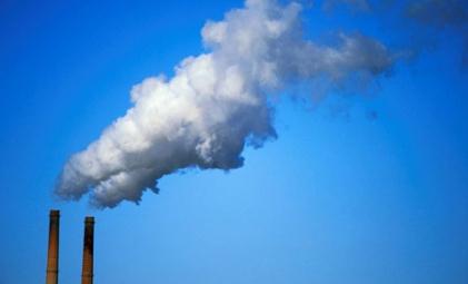 Score One For The Environment
. "Federal Court Upholds EPA's Global Warming Rules". Bloomberg Businessweek has the full story
here.
List Of Wettest Tropical Cyclones In The USA. Wikipedia has an interesting (and relevant) entry: "
Many of the wettest tropical cyclones in the United States have moved into the contiguous United States from the Atlantic Ocean, the Gulf of Mexico, and the eastern Pacific Ocean. The highest rainfall totals in the country have been measured across the Gulf Coast and lower portions of the Eastern Seaboard. Intermediate amounts have been measured across the Southwest, New England, and the Midwest. The northern Great Plains and Pacific Northwest have received the lowest amounts, as those regions lie exceptionally far from the breeding grounds of Atlantic and Eastern Pacific tropical cyclones. Tropical Storm Amelia's total rainfall is the most recorded within the contiguous United States. Tropical Storm Claudette
holds the national 24-hour rainfall record, with 42 inches (1,100 mm)
falling within a day. Taking place only one year apart, in 1978 and
1979, Amelia and Claudette are the two wettest tropical cyclones to have
occurred in Texas. Hurricane Hiki in 1950 led to significant rainfall in the mountains of Hawaii; with 52 inches (1,300 mm) of rainfall reported, this is the most rainfall reported to have been produced by a tropical cyclone within the United States."
* Cyclone "Easy" dumped 45.2" of rain on Yankeetown, Florida in 1950, the Florida state record.
NOAA Fire Detect. Here is a map showing real-time wildfires and forest fires around the USA, courtesy of NOAA's
Fire Detect program. Smoke plumes are also displayed - don't be surprised if you notice some extra-red, smoky sunsets in the coming days and weeks.
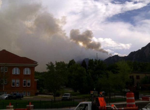
Boulder Blaze. Thanks to Dan G. Bergeron who snapped this photo of the Boulder, Colorado wildfire from Broadway, near the campus of CU.
Colorado Wildfires 2012: "Worst Wildfires In A Decade". More details from
Huffington Post: "
COLORADO
SPRINGS, Colo. -- Flames forced thousands of Colorado residents from
their homes over the weekend and disrupted vacation plans for countless
visitors as smoke shrouded some of the state's top tourist
destinations, including majestic Pike's Peak and tranquil Estes Park.
Colorado is having its worst wildfire season in a decade, with more
than a half dozen forest fires burning across the state's parched
terrain. Some hotels and campgrounds are emptying ahead of the busy
Fourth of July holiday."
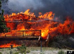
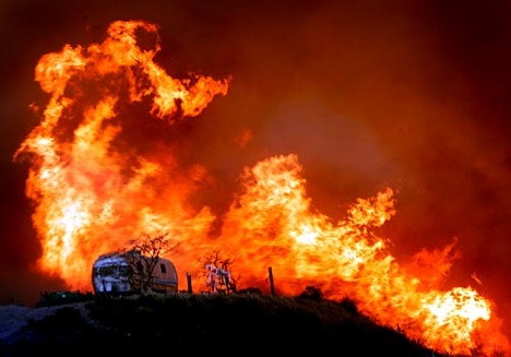
Photo credit above: "
In this Saturday, June 23, 2012 photo
provided by Darrell Spangler, a firefighter works the scene of a home
being consumed by flames in Estes Park, Colo. As many as 21 structures
were destroyed by the fire on Saturday. Eight separate wildfires are
burning across Colorado, which is seeing record-breaking heat." (AP Photo/Darrell Spangler)
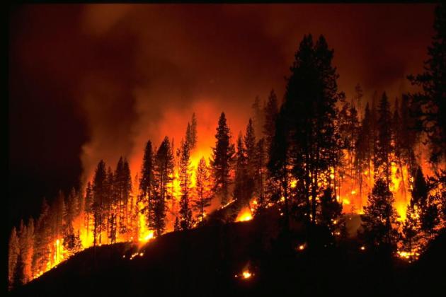
Heat-Driven Wildfires Continue To Consume The West.
100-degree plus heat, coupled with persistent (tinder-dry) winds, are
creating explosively-ripe conditions for wildfires in the western USA.
Here's an excerpt from
The New York Times: "....
Explosive
wildfires have burned across much of the West in recent weeks. In
southwestern New Mexico, the largest wildfire in state history has
burned nearly 300,000 acres. And in Utah, firefighters were nearing full
containment of the Dump Fire, which forced thousands from their homes
before evacuation orders were lifted on Saturday. By Sunday evening,
the evacuation orders were lifted for Manitou Springs, but they
remained for some of the other tiny mountain communities tucked around
Colorado Springs. With temperatures reaching well into the 90s on
Monday and summer winds whipping through the mountains, the 450
firefighters now battling the blaze were bracing for another tough day."
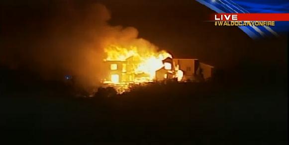
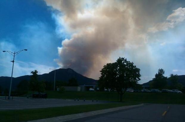
Colorado Springs Fire. This photo of the Waldo
Canyon Fire was taken near the Air Force Academy. Thanks to @RaRoulette
for sending this into WeatherNation TV.
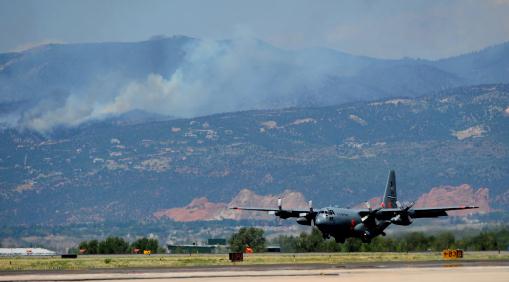
Colorado Wildfires: C-130 Air Tankers Called In For "Surge Capability". They're calling in (all) the reinforcements - the equivalent of fighting a war out west. Here's an excerpt from
The Denver Post: "
The
battle to contain devastating wildfires across Colorado reached a new
and more aggressive stage Monday as C-130 military tankers joined the
fight to bombard the Waldo Canyon blaze with thousands of gallons of
fire retardant. Four of the C-130 aircraft, two from the 302nd Airlift
Wing of the U.S. Air Force Reserve at Peterson Air Force Base and two
from the 153rd Airlift Wing of the Wyoming Air National Guard in
Cheyenne, took to the skies with 3,000 gallons of fire retardant in
each of their bellies."
Photo credit above: "
A C-130 Hercules lands at Peterson
Air Force Base for more fire retardant Tuesday, June 26, 2012, while
fighting the Waldo Canyon Fire. Four air tankers were battling the fire
west of Colorado Springs, Colorado. The tankers dropped 3,000 gallons
of water or fire retardant in less than five seconds, covering an area
one-quarter mile long by 100 feet wide." (Christian Murdock/Colorado Springs Gazette/MCT)
Colorado Evacuees Wait As Wildfires Blaze On. The
sad fact: it's still very early for fires of this magnitude and scope -
at this rate 2012 may turn into an historic year for wildfires west of
the Mississippi. Here's an excerpt from
The Los Angeles Times: "..
.Low
winter snowfall brought on an early fire season, said Tom Tidwell,
chief of the U.S. Forest Service. Years of drought, record-breaking heat
and low humidity, coupled with miles of dead, dry trees killed from
beetle infestations, have converged to make for the incendiary
conditions. On a fire danger index of 1 to 6, based on temperature and
moisture content of vegetation, Colorado has measured a "super 6" since
Saturday, said Steve Segin, public information officer for the Rocky
Mountain Area Coordination Center, which coordinates firefighting in
five states."
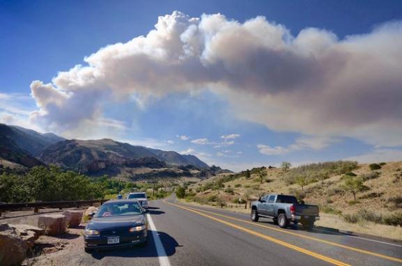
Photo credit above: "
Smoke billows from the hills west of Colorado Springs, Colo., where the Waldo Canyon fire had forced thousands to evacuate."
(Bob Pearson, European Pressphoto Agency / June 25, 2012).
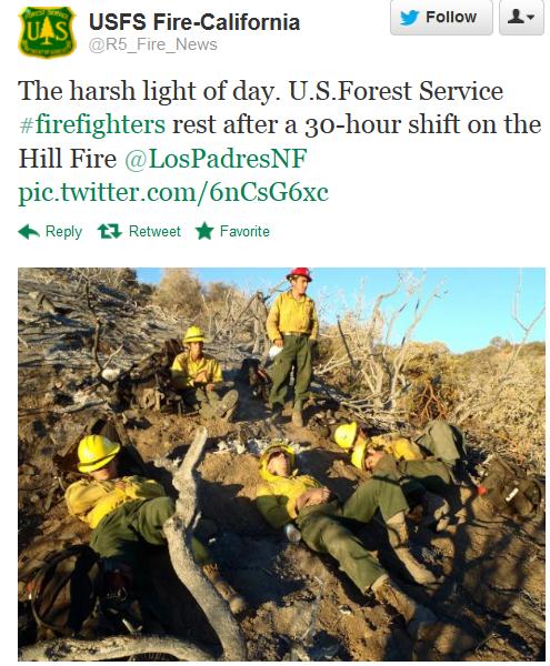
"The Harsh Light Of Day". Thanks to the U.S. Forest Service and
Twitter for passing this one along.
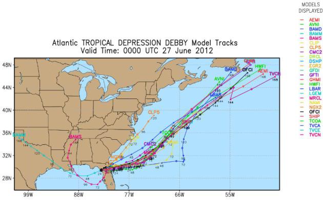 Good Riddance
.
Debby was downgraded to a tropical depression yesterday evening, before
sweeping into the Atlantic tonight and early Thursday, accelerating
quickly out to sea. All the models agree on that. Source
here.
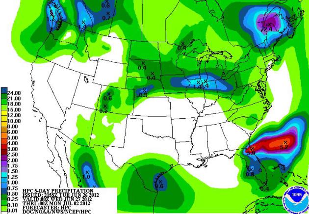 5-Day Rainfall Prediction
.
Another 5" of rain is predicted for the Jacksonville area, but Florida
will dry out the latter half of this week. T-storms may dump over 1" of
rain on Rockford, Madison and Chicago, but dry (hot) weather is the rule
through much of next week. Source:
NOAA.
Robot Boats To Sail Into Tropical Storms, Improve Forecasts. Here's a snippet from a fascinating article from Sun Sentinel and
seacoastonline.com: "
FORT
LAUDERDALE, Fla. — They don’t look much like boats, or robots for that
matter. Yet a small fleet of crewless watercraft are to be sent right
into the paths of tropical storms for the first time this year with an
important mission: Collect valuable ocean and atmospheric data that
should improve hurricane forecasts. “We want to obtain swift and
continuous data from the eye of the storm for several days, which is
very difficult to get in real time,” said Justyna Nicinska, a program
manager with the National Oceanic and Atmospheric Administration. Two
different models of the aquatic drones will be launched into
hurricane-prone areas, likely near Puerto Rico and Key West. Both
models will be satellite-linked to transmit the data they collect back
to computers at the National Hurricane Center west of Miami." Photo above: NASA.
Social Media And Natural Disasters: Tropical Storm #Debby Proves Still Room For Improvement. Here's an excerpt of a very interesting post from
The Marketing Nut: "
For
those that may not be aware there is a tropical storm hitting the
South in the USA. Tropical storm Debby (#Debby on Twitter) decided to
hang out near Florida starting this past weekend. She has brought with
her massive amounts of rain and tornados. Practically the entire state
of Florida (where I live) has been under Tornado watch or Tropical Storm
warning since Sunday. Our home has water seeping thru carpet in two
rooms and an end to the rain is not on the horizon in the near future.
The purpose of this post is not to share with you our rain stories but
to share some discoveries I made during the past 48 hours regarding social media and the businesses who are and are not part of the #Debby conversation."
Cloud Formation Discovery Expected To Impact Future Military Operations. The Navy is pushing ahead with ground-breaking research, as reported by
globalsecurity.org: "
DAHLGREN,
Va. (NNS) -- A newly discovered radar capability to detect individual
cloud hydrometeors in the free atmosphere can impact future performance
of combat systems and military decision making, Navy scientists
announced June 21. The technical details of the capability - made
possible with a very high-resolution Doppler radar - are expounded in a
paper entitled "Radar Observations of Individual Rain Drops in the
Free Atmosphere" published in the Proceedings of the National Academy
of Sciences journal May 28. "This series of experiments demonstrate
classic science," said Dr. Mark Anderson, a Naval Surface Warfare
Center Dahlgren Division (NSWCDD) principal systems scientist who
co-authored the paper. "The Navy's ultimate hope in understanding these
cloud formations is to improve the description and forecasting of
severe weather which in-turn would help the Navy and DoD (Department of
Defense) in evaluating systems performance and in day-to-day decision
making." Image above: NASA.
How Navy Supercomputers Help Sailors Beat Ancient Nemesis.
We have a theme going here. My hope is some of that military
supercomputer know-how eventually trickles down to the private sector.
CNET.com has the story; here's an excerpt: "
MONTEREY,
Calif.--One after another, the framed pictures on both walls of the
narrow hallway tell the story: submarines and naval ships churning
white wakes as they slash through open ocean, each photo accompanied by
unbidden gratitude. "Thank you for your team's efforts & hard work!
You ensure my safety and enhance my tactical advantage," one reads.
Welcome to the U.S. Navy's Fleet Numerical Meteorology & Oceanography Center.
That long-and-hard-to-say name notwithstanding, this is one of the
United States military's sharpest weapons in the never-ending battle for
survival in rough seas all around the globe."
Map credit above: Fleet Numerical Meteorology & Oceanography Center
Lightning Fatalities in 2011. NOAA has a
URL
that describes all lightning-related deaths last year - the vast
majority of victims were camping or fishing. Remember, lightning is lazy
- it wants the easiest way from the cloud base to the ground. If you're
the tallest object in the area you run the risk of turning into a human
lightning rod. Not good.
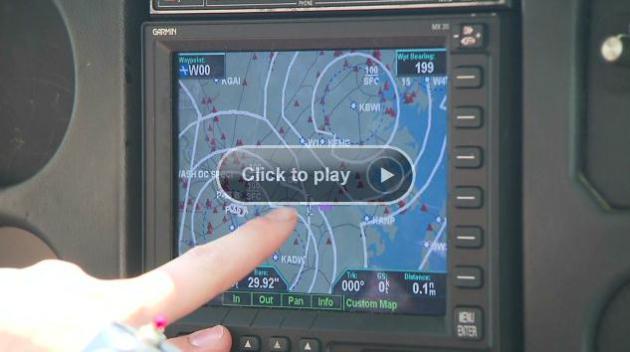
NTSB: Cockpit Weather Displays Could Mislead Pilots.
There's always a lag between when a Doppler radar image is "captured"
by a local NWS weather service office - and when that data reaches the
public. In the case of aviation, with split-second decisions involving
routing around T-storms, that 10-20 minute lag can be dangerous, as
reported by
CNN.com; here's an excerpt: "
Weather
imagery that private pilots see on cockpit displays -- advertised as
"real time" data by some firms -- could be up to 20 minutes old, giving
pilots a dangerously false sense of existing conditions, federal
safety officials warned this week. While pilots generally know that
weather information is five minutes old, the actual age can be much
older, the National Transportation Safety Board said in a safety alert.
That "could mean the difference between life and death" in rapidly
changing weather conditions, said NTSB Chairwoman Deborah A.P. Hersman.
The problem affects thousands of general aviation aircraft, ranging
from small two-seat aircraft to large corporate jets, which use Next
Generation Radar, or NEXRAD, systems. It does not impact large
commercial jetliners, which use other weather-monitoring systems."
"Ask Paul". Weather-related Q&A:
"
Paul - After seeing the morning forecast today for out west,
there was pretty much Red Flag Advisories in the mountain states. I am
planning a trip to Yellowstone National Park at the end of July. What is
the risk of fire weather at that time? Thanks."
Aaron Coates, Golden Valley
Aaron - I'm genuinely worried about the scope and intensity of
wildfires this summer. Fire season is starting 1-2 months early, and I
suspect things will get worse before they improve by autumn. Peak fire
season is historically July, August and September. A lack of winter
snow, coupled with an early spring and unusually hot, dry weather, has
increased the fire risk out west. I wouldn't change my plans right now
for Yellowstone - but I would keep monitoring conditions and have a Plan
B in case active fires are going on nearby in late July.
______________________________________________________________________________
"
Hi Paul - this is Karl from Allied Tactical
Defense Firearm Training. We are wondering what the weather is
projected for on the 28th and 29th. We have a two day training event
and the Minnesota Horse and Hunt Club in Prior Lake and want to make
sure our clients are prepared for what mother nature has planned .
thanks much. www.alliedtacticaldefense.com Thanks Paul."
Karl Kirschstein
Karl - right now it looks dry Thursday and Friday.
You'll notice a slight dip in temperature and dew point on Thursday
behind a very weak cool front, but that steamy boundary shifts north
again Friday, when temperatures may reach the low to mid 90s by late
afternoon. Morning hours will be tolerable, especially Thursday.
T-storms may rumble in Friday night, but you should be OK during the
daylight hours. Good luck!
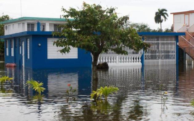
Car Accidents: 8 Driver Do's And Don'ts In Hurricanes, Floods And Storms That Flood. Here's an excerpt of some very good advice from the Brooklyn edition of
about.com:
DON'T Stop to Take That Amazing Photo of the Swollen River During Floods
"
If you find yourself staring at a swollen river overflowing that
picturesque, don't pop out of the car and start snapping pictures and
sending them from your mobile phone to your friends.
Everyone loves to get that unusual photo, but don't waste
precious time being a citizen journalist if you happen to be driving
through an area that's starting to flood.
Act quickly. That means move to higher ground."
DO Detour Around a Dangerous Route to Avoid Flood Areas
"There's always another way around something. Detour around a
flood zone even if it takes time. Or, postpone whatever meeting or
errand you were going to drive to if there's a flood warning. Is it
really essential? If not, don't go."
DON'T Try to Drive Through a Water-Covered Roadway
"You can't really judge the depth of a flood, and certainly not
when approaching in a car. How deep is it? Will you get stuck? If the
water is flowing, the current might be stronger than you'd expect."
* photo above courtesy of NOAA.
Bom Threat Disposal? There's An App For That. Now I've officially seen everything - details from
gizmag.com: "
Imagine
if you were a police officer who suddenly realized that the abandoned
vehicle you were assessing contained a bomb. While you might have had
some training in how to handle such situations, would it all easily
come back to you in the heat of the moment? Well, even if it wouldn’t,
you might still know what to do ... if you were using the FiRST app.
The U.S. Department of Homeland Security developed the application for
emergency response personnel, to serve as a step-by-step guide for
managing bomb threats."
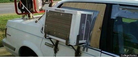
15 Funniest Ways To Beat The Heat. Not sure we'll be
chuckling out there later today, but here is an attempt to find humor
in our near-triple-digit heat, courtesy of
Huffington Post: "
With a brutal heat wave tearing across the U.S.,
those who aren't clinging to their A.C. units are probably looking for
new ways to beat the heat. With temperatures reaching up to 100
degrees in some places, those without air conditioning need to get
creative, fast. But don't worry! We found 15 funny, DIY ways to beat
the heat by creating your own cooling system. Some of the ideas are
pretty brilliant life-hacks
(like a fan mounted on the driver's side of a car) and some are just
plain dangerous and dumb (like taping a fan to the ceiling), but
regardless, the spirit of creative problem solving is what counts. Vote
for the funniest solution below."
Photo credit above: College Humor.
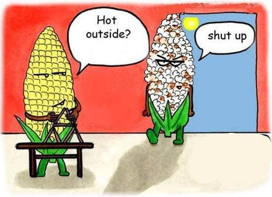
It's Hot Outside: Exhibit A.
It's Hot Outside: Exhibit B.
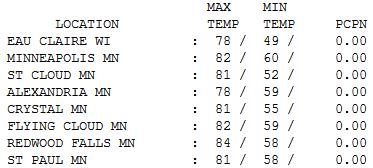 Tuesday Numbers
.
Yesterday was a perfectly normal day, an average day for late June in
Minnesota. A dry sky prevailed statewide, only a few light showers and
sprinkles this morning (most of which evaporated before reaching the
ground). Highs ranged from 78 at Eau Claire and Alexandria to 81 St.
Cloud, 92 in the Twin Cities and 84 at Redwood Falls.
"Gonna Be A Hot One". Photo courtesy of Matt McKean, AP
Paul's Conservation Minnesota Outlook for the Twin Cities and all of Minnesota:
TODAY: Heat Advisory. Air Pollution Health Advisory. Sizzling sun - free sauna. Dew point: 75. Winds: S 10-15. High: 97 (feels like 105 by late afternoon/evening).
WEDNESDAY NIGHT: Warm and sultry, dew points in the 70s. Low: 73
THURSDAY: Slightly more tolerable. Some sun, dip in humidity. Dew point: 58. High: near 90
FRIDAY: Sizzling heat returns. Dew point: 63. Low: 69. High: 95
SATURDAY: Few T-storms possible. Dew point: 68. Low: 68. High: 88
SUNDAY: Sunnier, hotter again. Dew point: 70. Low: 69. High: 92
MONDAY: Steamy sun, partly sweaty. Dew point: 71. Low: 71. High: 91
TUESDAY: Dog Days of July. Sticky sun. Dew point: 73. Low: 73. High: 93
4TH OF JULY: Intervals of sun, still very hot. Low: 72. High: 92
Flirting With 100?
Welcome to one of the hottest days of the year.
The same inflamed, desert airmass that sparked 105 in Denver Monday
(tied for the hottest reading ever recorded) will brush southern
Minnesota later today; a few thermometers may approach 100. Factor in a
dew point in the mid-70s and it may feel like 105-110 F.
Don't even THINK about leaving a child (or pet)
in a parked vehicle. When it's 95 F. outside the temperature inside your
vehicle can approach 200 F. within half an hour; a deadly heat spike.
According to Greg Spoden at the MN DNR, the Twin
Cities have endured 100-degree heat on 10 days since 1982. We may come
close later today.
Humidity levels drop off slightly Thursday, but
highs flirt with 90 into much of next week, as a bloated ridge of high
pressure stalls over America's midsection. No more sweeps of cool, clean
Canadian air until further notice. The Dog Days of Summer have arrived a
few weeks ahead of schedule, just like everything else this year. One
silver lining to this antiperspirant-worthy weather pattern: no monsoon
rains are brewing.
T-storms may rumble across southern Minnesota on Saturday, but much of the 4th of July week looks dry, and "hot enough".
Climate Stories...
U.S. Appeals Court Upholds EPA Greenhouse Gas Emission Rules. Think Progress has the story; here's an excerpt: "
The U.S. Court of Appeals for the District of Columbia Circuit
today unanimously ruled in favor of the Environmental Protection
Agency’s (EPA) legal authority to limit industrial carbon pollution
under the Clean Air Act to protect Americans’ health. Carol M. Browner,
former Environmental Protection Agency Administrator, and
Distinguished Senior Fellow at the Center for American Progress said:
“The Court’s decision should put an end, once and for all, to
any questions about the EPA’s legal authority to protect us from
industrial carbon pollution through the Clean Air Act. This decision is
a devastating blow to those who challenge the overwhelming scientific
evidence of climate change and deny its impact on public health and
welfare.”
Background Claims By Minnesota State Senate's Global-Warming Skeptic Fail To Check Out. Here is a video clip - and corrected version of a story Don Shelby wrote for
Minnpost.com on June 15, 2011: "
The
Minnesota Senate's most notable authority on global warming comes from
East Bethel. Michael Jungbauer was once its mayor. He is in his third
term at the state Legislature and he has fashioned himself into a force
of nature when it comes to the environment. But Jungbauer doesn't
believe the planet is warming. In fact, he told me, "I think the earth
is going to cool." From his position on the Senate Energy, Utilities
and Telecommunications Committee, he has the power to change the way
Minnesota approaches the issue. And his influence is apparent. The
Minnesota Legislature has been busy undoing much of Minnesota's
nation-leading policies enacted to deal with global warming."
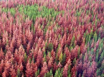
Goodbye To Mountain Forests. Here's an excerpt of an article from
The New York Times: "
When the smoke finally clears and new plant life pokes up from the scorched earth after the wildfires raging in the southern Rockies, what emerges will look radically different than what was there just a few weeks ago. According to Craig Allen, a research ecologist with the United States Geological Survey
in Los Alamos, New Mexico, forests in the region have not been
regenerating after the vast wildfires that have been raging for the last
decade and a half. Dr. Allen, who runs the Jemez Mountains Field Station at Bandelier National Monument,
says those forests are burning into oblivion and grasslands and
shrublands are taking their place. “Rising temperature is going to drive
our forests off the mountains,” he said."
A Fresh Look At Oil's Long Goodbye. Here's an excerpt of an article (and video) from Andrew Revkin at
The New York Times (subscription may be required to view this): "
My bedtime reading tonight is “Oil: The Next Revolution – The unprecedented upsurge of oil production capacity and what it means for the world.”
This mind-bending report points to a prolonged period of rising oil
production, particularly in the United States (for reasons laid out
below), and a potential collapse in oil prices, with all kinds of
implications for security, international politics, the economy and,
without doubt, climate. The report is written by Leonardo Maugeri, a top oil company executive from Italy who is currently a research fellow at the Geopolitics of Energy Project
of Harvard’s Belfer Center for Science and International Affairs.
Here’s a video interview with Maugeri posted by the Belfer Center."
Hey California, Hot Enough For 'Ya? Here's an excerpt of an Op-Ed in
The L.A. Times: "
....But wait, there's more! It seems that the Golden State is going to get goldener, as in burnt-toast gold:
“By the middle of the century, the
number of days with temperatures above 95 degrees each year will triple
in downtown Los Angeles, quadruple in portions of the San Fernando
Valley and even jump five-fold in a portion of the High Desert in L.A.
County,” according to a new UCLA climate change study.
Of course, I like to find silver linings in bad news. So here
it is: We’ll be hot, but if we want to go to the beach to cool off,
the ocean won’t be as far away."
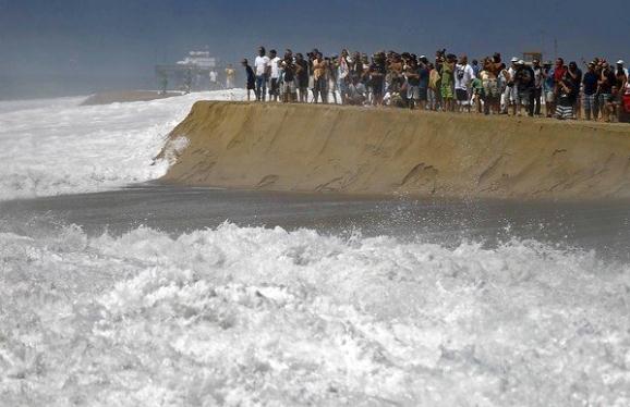
Photo credit above: "
The destructive power of rising sea
levels will be felt first when storms hit vulnerable places such as
Newport Beach, said Gary Griggs, director of the Institute of Marine
Sciences at UC Santa Cruz. Above, the Wedge at Newport Beach."
(Luis Sinco / Los Angeles Times / June 25, 2012).
"The World Will Be Drawn Into War Over Resources." Here's a portion of an Op-Ed from
The Guardian: "
Massive
geopolitical shifts seldom announce themselves with a bang. They tend
instead to creep up slowly, until it's hard to be sure exactly when
they began. I remember going to buy some steel about six years ago, and
being staggered by the price. "Ah," the man in the hardware store
explained, "it's the Chinese, you see. They're buying up so much steel,
the price has gone through the roof." The last time I visited my
brother, all the lead had been stripped from his garden shed – the
second theft in two months – thanks to rocketing lead prices. And it
must have been around the time of the Iraq war that I recall first
hearing someone say the next big war would be fought over water. At the
time the prediction had sounded far-fetched; these days, it's a
commonplace."


No comments:
Post a Comment