77 F. high Monday in the Twin Cities.
82 F. average high for June 25.
68 F. high on June 25, 2011.
95-100 F. heat possible late Wednesday in the Twin Cities.
Tomorrow should be the hottest day so far in 2012.
78.6 F. predicted dew point 7 pm tomorrow (NAM model).
38 F. low at International Falls Monday morning, tying the old record set in 1996.
105 F. high at Denver, Colorado yesterday, tying the record for the hottest temperature ever recorded.
109 F. high at Sydney, Nebraska, the hottest temperature ever recorded.
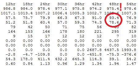
Withering Wednesday? The 2 meter temperature is
predicted to be 93.4 F. at 7 pm tomorrow, with a dew point of 78.6 F. I
want to see another run - but this could translate into a high ranging
from 95-100 F. tomorrow afternoon in and near the metro. Not sure the
dew point will rise to 78.6, but mid-70s seem likely, meaning a
potential heat index tomorrow as high as 105 F. by late afternoon and
evening. Yes, tomorrow will probably take your breath away.
7.11" rain reported at Tampa Sunday, breaking the old June 24 record of 5.29" in 1995.
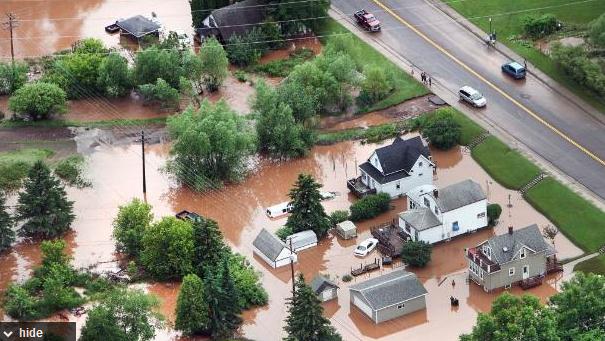
"
An event of this magnitude in 24 hours cannot be handled no matter what system we design," he said."
- from a Star Tribune article below focused on rebuilding Duluth's
critical infrastructure to better withstand extreme rainfall events in
the future. Photo courtesy of Reuters.
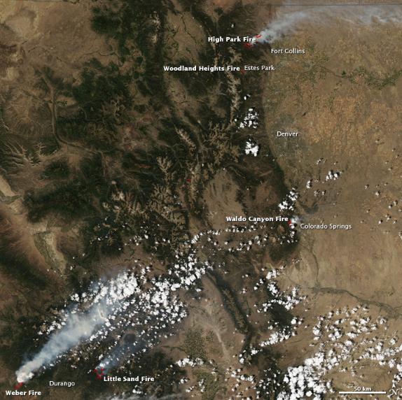
"Nearly half of the United States’ airborne fire suppression
equipment was operating over Colorado on June 25, 2012, CNN reported,
as tens of thousands of acres burned." - From NASAs Earth Observatory.
"The sea level on a stretch of the U.S. Atlantic coast that
features the cities of New York, Norfolk and Boston is also rising up
to four times faster than the global average." - from a Yahoo News report on sea levels rising faster than computer models predicted; details below. Photo: MSNBC.
Duluth Eyes Rebuilding For A Wetter Climate. No
infrastructure can withstand 10" of rain in less than 36 hours, but the
City of Duluth is taking steps to rebuild for the new, warmer, more
extreme environment we find ourselves in today. Here's an excerpt from
The Star Tribune: "....
Duluth
is maybe in the first wave of cities to adapt to climate change," said
University of Minnesota Extension climatologist Mark Seeley. Climate
scientists say increasing precipitation, particularly from intense
thunderstorms, is a symptom of ongoing climate warming, because warm
air holds more water vapor than cooler air. The Upper Midwest saw a 31
percent increase in "intense" rainfalls -- the statistical 1 percent
events -- from 1958 to 2007, over previous decades, according to the
National Climatic Data Center. Last Tuesday and Wednesday's Duluth
rainfall, measuring from 7 to more than 10 inches across the city, was
in some places nearly double what's regarded as Duluth's 1
percent-chance rainfall. That made it "next to impossible to plan for,"
Shaffer said."
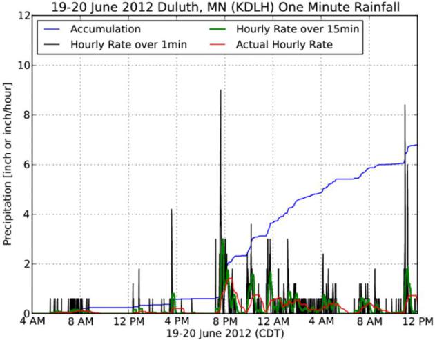
"Significant Flood Event". IEM,
The Iowa Environmental Mesonet has more details on last week's historic flooding in Duluth: "
A
significant flood event impacted areas in and around Duluth, Minnesota
this past week due to heavy rainfall over a multi-day period. The
feature chart presents the one-minute interval precipitation
observations from the Duluth ASOS sensor. Total precipitation for this
event was nearly seven inches at this site. This rainfall caused record
river heights in the area and significant damage."
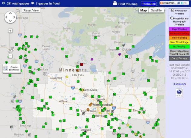
Flood Update. Moderate flooding is still being
reported at Brainerd. major flooding at Aitkin (where water levels
continue to rise) and the St. Louis River at Scanlon (where river levels
are falling rapidly). Map courtesy of
NOAA.
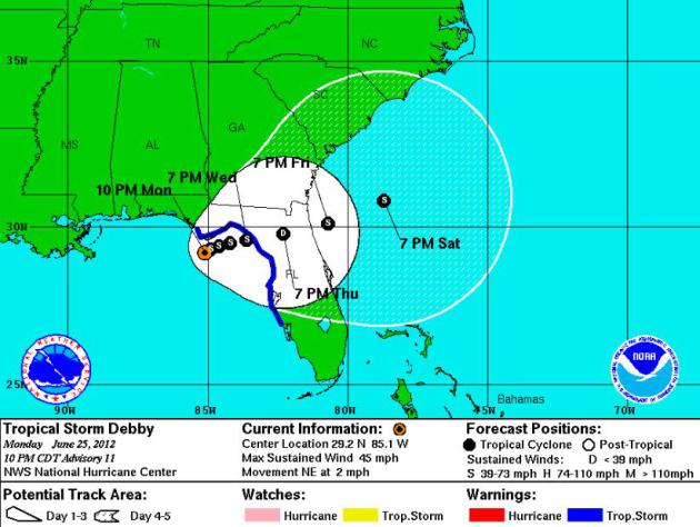
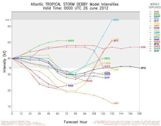
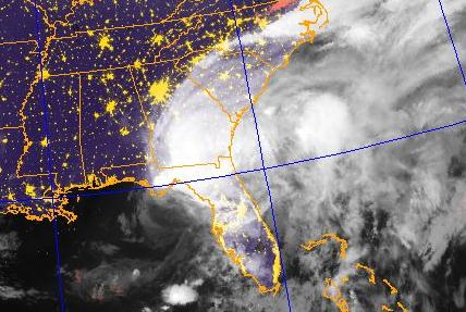
Slow Motion Storm Track. Tropical Storm Debby is nearly stationary - meandering around the northeastern Gulf at 2-4 mph.
NHC
forecasts the storm to weaken into a tropical depression near Ocala by
Thursday evening, pushing out into the Atlantic late Friday.
Debby: Weakening - Then Strengthening? The core of
the storm is about to pass over Florida, robbing "Debby" of much of its
strength (but not its rainfall potential). By late Friday the storm will
emerge near Jacksonville, potentially intensifying over warm Gulf
Stream waters this weekend.
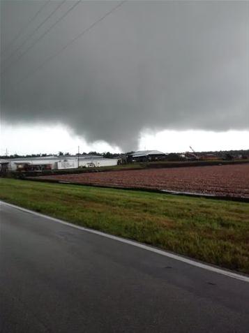
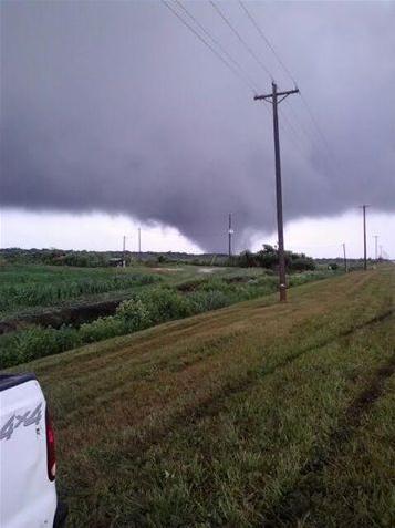
Debby's Violent Side Effects. Tropical storms can be
just as damaging as hurricanes, especially slow-movers like "Debby",
which is creeping along at 2-3 mph. As these massive cyclones encounter
land friction can spin up tornadoes, like the one that hit Lake Placid
(Highland County) Florida. Details and credit: "
Attached are two
pictures taken by my brother Skip (Hugh) Dent from his hometown of Lake
Placid, Florida. There were taken June 24, and you have his permission
to use them." - Stephen M. Dent, Golden Valley. Thank Stephen (and
Skip). I very much appreciate you thinking of me - and passing these
amazing photos along.
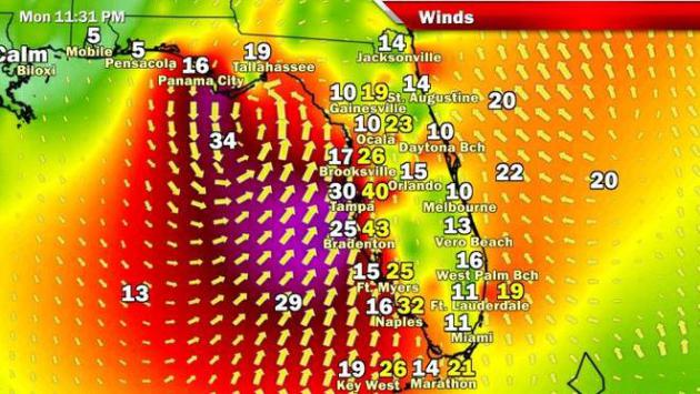
Weakening Debby Bound For Big Bend. Here's an excerpt from an update at
The Miami Herald: "
Tropical
Storm Debby began weakening Monday in the Gulf of Mexico but not
enough to spare an already soaked Central Florida several more days of
rain. The National Hurricane Center shifted Debby’s path yet again,
steering the slow-moving storm across Florida’s Big Bend area and North
Florida later this week. Over the next week, forecasters said it could
dump from 10 to 20 more inches of rain over the area. On the positive
side, Debby was disorganized and growing weaker. Dry air was swirling
into the core and wind shear shredded its rotating storm bands. Debby
had been stalled so long that it was also churning up cooler ocean
waters, further sapping its power."
Map above courtesy of
Bay News 9 in Tampa.
Storm Debby Shifts East, May Miss U.S. Gulf Oil Patch.
Reuters has the story - here's an excerpt: "
U.S.
companies shut in roughly 23 percent of the nation's oil and natural
gas production in the Gulf of Mexico on Sunday as a precaution due to
Tropical Storm Debby, even as forecasters revamped projections to show
the storm could head north and miss the vital offshore energy
facilities. The U.S.
National Hurricane Center reported late Sunday afternoon that the
storm's expected path toward Florida, away from the U.S. Gulf waters
that are home to about 20 percent of U.S. oil and 6 percent of natural
gas output."
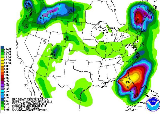
2012: The Year Of All Or Nothing. While fires
continue to rage across Colorado and New Mexico, the rain just won't
stop over north Florida. NOAA's latest QPF shows a 14.2" bulls-eye of
rain near Jacksonville by Sunday. Locally, amounts could go over 20"
from Tropical Storm Debby.
Wildfires Across Colorado. Here's an interesting post from
NASA's Earth Observatory: "
Nearly
half of the United States’ airborne fire suppression equipment was
operating over Colorado on June 25, 2012, CNN reported, as tens of
thousands of acres burned. Fires raged in southwestern Colorado,
northeastern Colorado, and multiple locations in between. The Moderate
Resolution Imaging Spectroradiometer (MODIS) on NASA’s Aqua
satellite captured this natural-color image on June 23, 2012. Red
outlines approximate the locations of actively burning fires. The High
Park and Weber Fires produced the largest plumes of smoke. The High Park Fire
continued to burn west of Fort Collins. Started by lightning on June
9, 2012, this blaze had consumed 83,205 acres (33,672 hectares), making
it the second-largest fire in Colorado history, after the Hayman Fire
that burned in 2002. As of June 25, more than 2,000 people were
fighting the High Park Fire, and firefighters had it 45 percent
contained, according to InciWeb. Nevertheless, The Denver Post
reported that the fire had destroyed 248 homes, making it the most
destructive in Colorado history, even if it was not the largest."
Read more here: http://www.miamiherald.com/2012/06/25/2867198/weakening-debby-bound-for-big.html#storylink=cpy
"Farthest Golf Shot Caught In A Moving Car" Record Set. Wow, I wish I had this much free time.
Gizmag.com reports: "
We’re
not sure how hotly contested this particular world record is, but at
the very least it does provide a nice bit of video to start the working
week – particularly for those who spent the weekend hacking around the
golf course chasing that elusive hole in one. Former Formula 1 driver
David Coulthard has claimed the record for the “farthest golf shot to
be caught in a moving car, ever.”
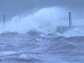
What Not To Do During A Tropical Storm.
Thanks to Wen Dee for passing along this photo of a couple lounging in
the roiling seas off Bayshore Boulevard in Tampa. Good grief.
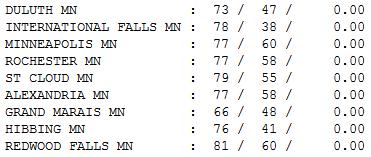
Magic Monday. Blue sky, light winds, low humidity -
dew points in the 40s. Too bad it didn't fall on a Saturday. Monday
highs ranged from 73 at Duluth to 77 in the Twin Cities, 79 St. Cloud
and 81 at Redwood Falls.
Paul's Conservation Minnesota Outlook for the Twin Cities and all of Minnesota:
TODAY: Warm sun. Dew point: 54. Winds: 10-20. High: 84
TUESDAY NIGHT: Mostly clear and warmer. Low: 67
WEDNESDAY: Blazing heat, feels like 105. Dew point: 74. High: 96. Heat Index: 105+
THURSDAY: Some sun, not as steamy - a bit less humid. Dew point: 59. Low: 71. High: 89
FRIDAY: Sticky sun, hot again. DP: 65. W 5-10. Low: 69. High: 93
SATURDAY: Muggy, few T-storms possible. Dew point: 70. Winds: S 8. Low: 68. High: 86
SUNDAY: Sunnier, drier, hotter. Dew point: 72. Low: 71. High: 92
MONDAY: Stinking hot again. Dew point: 74. Low: 73. High: 94
Hot Groove
"What dreadful hot weather we have! It keeps me
in a continual state of inelegance" wrote Jane Austen. Yes, it's hard to
look composed when the mercury pushes into the 90s, with a drippy dew
point above 70.
A Small Cooler Advisory and Hot Vinyl Car Seat
Warning has been issued for tomorrow; another heat spike imminent. Highs
will reach the mid 90s, a few thermometers close to home may brush 100
F. Factoring a dew point in the mid 70s and it may feel like 105 in the
shade by the dinner hour tomorrow - probably the hottest day of the
year, so far.
We've already enjoyed (?) 7 days of 90-degree
heat. Average for summer is 14. I'm predicting 20-25 days above 90 this
year. Don't bet the farm on that prediction, but I'm looking at cycles.
Right now we have no La Nina or El Nino to nudge
weather patterns in a specific direction. But the weather is falling
into a hot groove - a persistent heat-pump high amplifying over the
Plains and Midwest, while unusually cool, wet weather plagues the
Pacific Northwest and New England.
The jet stream is stuck in a rut,one that will
keep us steamy much of summer. CPC, NOAA's Climate Prediction Center,
forecasts a hotter than normal summer for most of the USA.
Mid-90s are likely tomorrow - maybe 4-5 day
above 90 by early next week, with a few Saturday T-storms. The prescient
ECMWF model predicts a rerun of pleasant 70s by the 4th of July. Then
again, that may be wishful thinking.
Climate Stories...
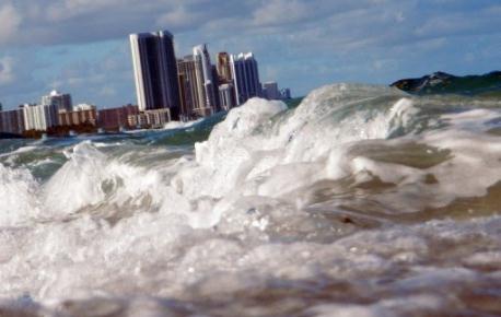
Rising Sea Level Puts U.S. Atlantic Coast At Risk: Report. Here's an excerpt from
Yahoo News: "The
sea level
on a stretch of the US Atlantic coast that features the cities of New
York, Norfolk and Boston is rising up to four times faster than the
global average, a report said Sunday. This increases the flood risk for
one of the world's most densely-populated coastal areas and threatens
wetland habitats, said a study reported in the journal Nature
Climate Change.
Since about 1990, the sea level along the 1,000-kilometre (620-mile)
"hotspot" zone has risen by two to 3.7 millimetres (0.08 to 0.15
inches) per year. The global rise over the same period was between 0.6
and one millimetre per year, said the study by the
US Geological Survey (USGS).
If global temperatures
continue to rise, the sea level on this portion of the coast by 2100
could rise up to 30 centimetres over and above the one-metre global
surge projected by scientists, it added."
Photo credit above: "
Buildings are seen near the ocean as
reports indicate that Miami-Dade County in Florida in the future could
be one of the most susceptible places when it comes to rising water
levels due to global warming. The sea level on a stretch of the U.S.
Atlantic coast that features the cities of New York, Norfolk and Boston
is also rising up to four times faster than the global average." AFP Photo/Joe Raedle.
Oil Companies Fear Financial Impact Of Climate Change.
Clean Technica has the article; here's an excerpt: "
We
all know oil companies make an amazing amount of money ($33.5 billion
in 2012 first quarter profits by the Big Five alone) selling gasoline
and other petroluem products to the world. The U.S. government gives
billions of our tax dollars back to these companies every year. The oil
companies spend big to keep the system running this way. Not a bad
system, if you're a huge fossil fuel corporation. Unfortunately, the oil
companies make a product that warms our planet and disrupts our
climate, which affects all of us. So what does the fossil fuel industry
do? They fund organizations and people that make the case for denial and
inaction. So this is an industry that profits from products that
science shows will change the climate, then spends money on cover-up."
Climate Change Is A "Wicked Problem". Here's an excerpt of a Jay Rosen post that caught my eye at a science-related blog, "
Die Klimazwiebel": "...
Every
wicked problem is unique, so in a sense there is no prior art and
solving one won’t help you with the others. No one has “the right to be
wrong,” meaning enough legitimacy and stakeholder support to try things
that will almost certainly fail, at first. Instead failure is savaged,
and the trier is deemed unsuitable for another try. The problem keeps
changing on us. It is never definitely resolved. Instead, we just run
out of patience, or time, or money, or political will. It’s not possible
to understand the problem first, then solve it. Rather, attempts to
solve it reveal further dimensions of the problem. (Which is the secret
of success for people who are “good” at wicked problems.) Know any
problems like that? Of course you do. Climate change! What could be
more inter-connected than it? How the hell do we define it? Is it the
burning of fossil fuels? Is it modernization? Capitalism?"
Climate Denial Hits Brazil. The story from Chris Mooney at
Desmogblog.com; here's an excerpt: "...
Basically,
the high profile denialism achieved liftoff due to the popular comedian
Jo Soares, who gave it quite a boost on his widely watched
Letterman-like Programma do Jo (The Jo Show, we'll call it). In May,
Soares had on the geographer Ricardo Auguston Felicio, for a nearly
half-hour denial-fest that has gone pretty viral. Who is Ricardo Augusto
Felecio? He's a professor at the University of Sao Paulo, specializing
in the study of Antarctic climate. His faculty webage says - according
to Google Translae - that he "Conducts research and serious criticisms
of climate variability and its consequences, demystifying the
"anthropogenic climate change" and its ideology embedded". In other
words, he seems to be wearing his denial proudly on his sleeve."


No comments:
Post a Comment