By Paul Douglas
"What makes this heat wave different?"
Air from the desert southwest, mixing with Gulf moisture, coupled with a
holding pattern aloft. The usual parade of fronts and hiccups of
Canadian cool fronts has been put on indefinite hold.
This is an extraordinary pattern. For a
few hours Thursday Norton Dam, Kansas was the hottest spot on Earth
(118 F). In a 2-day period - 32 towns from Colorado to Indiana set
all-time high temperature records.
Extreme heat and moisture set off a
deadly "derecho" Friday, a boomerang-shaped swirl of thunderstorms,
spawning hurricane-force gusts. From Chicago to Washington D.C.
overheated Americans experienced the equivalent of a 20-minute, Category
1 hurricane.
We shouldn't be too surprised: the hotter the air, the more moisture it can hold, increasing the potential for extreme storms.
Get ready for a week of 90s; mid-90s
today, 1-3 days this week near 100 F. Dew points top 70, making it feel
like 105-110. Serious heat.
In this kind of tropical stew timing random T-storms is a fool's errand. I'm not even going to try.
Slow down, stay hydrated; infants and the elderly are most at risk from the heat.
Think cool thoughts. This too shall pass
___________________________________________________________________________________________
Todd's Conservation MN Outlook for the Twin Cities and all of Minnesota:SUNDAY: Steamy sun, slight chance of a T-storm. Dew point: 68. Winds: S 10-15. High: 94
SUNDAY NIGHT: Slight chance of a lingering storm. Low: 74
MONDAY: Hot and very humid! Unsettled - a few heavy thunderstorms in the area. Dew point: 73. Heat Index: 100-105. High: 96
TUESDAY: Heat wave continues. Unsettled, few lingering T-storms Dew point: 73. Low: 76 High: 95
4th Of JULY: Summer sizzle. Hot, hazy & humid. Whew... Slight chance of thunder late. Dew point: 74. Low: 73. High: 95
THURSDAY: Is it over yet? Sizzling. Some afternoon thunder possibe. Dew point: 74. Low: 75. High: 98
SATURDAY: Still warm and unsettled. Low: 69. High: 89
Summer Sizzle
Thanks to my good friend, Rich Koivisto,
from Duluth MN for the picture below. This picture really sets the mood,
doesn't it? Not that we want to 'feel' any hotter, but the week ahead
could possibly be the hottest week of 2012!

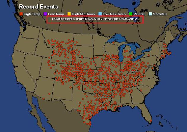
Extreme Heat
Look at all the record highs that have
either been tied or broken across the nation over the past week.
According to hamweather.com there have been nearly 1500 records!
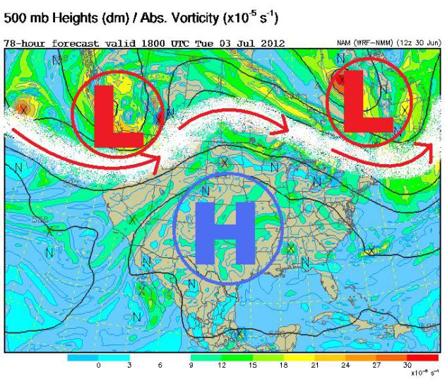
Why So HOT?
The 500mb vorticity map below shows the
reason for the extreme heat. The strong upper level winds have lifted
into Canada and a resulting "Omega" block has settle across the nation.
Two low pressure systems on either coast of Canada have kinked the jet
stream into what looks like the Greek letter Omega. Underneath, there is
a huge high pressure system... a big HOT dome that isn't going away any
time soon.
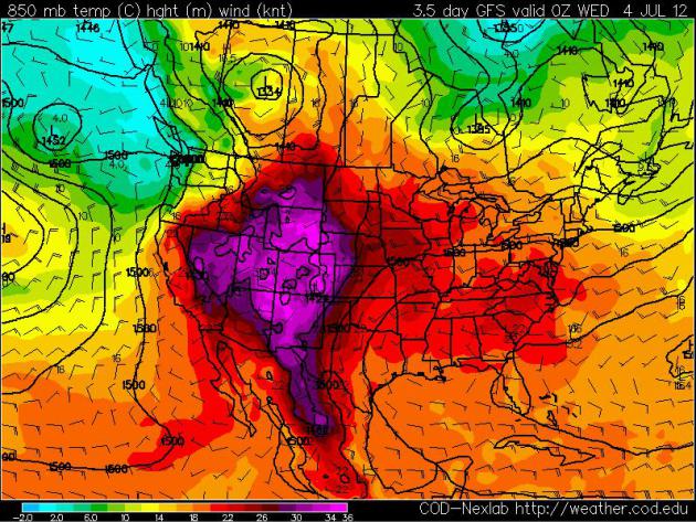
Temperatures Aloft
Look at the temperature map a few
thousand feet off the ground. The 850mb temps show lots of red and
purple, which is pretty typical for this time of the year. In fact, the
warmest part of the entire year typically comes around the early to
middle part of July.
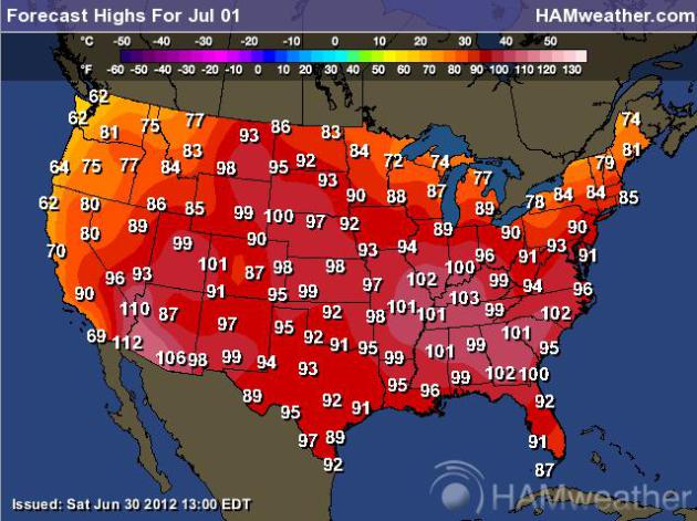
Sunday Surface Temps
Surface temperatures are still pretty
summery. 90s and 100s are still likely through much of the nation and
through most of the week.
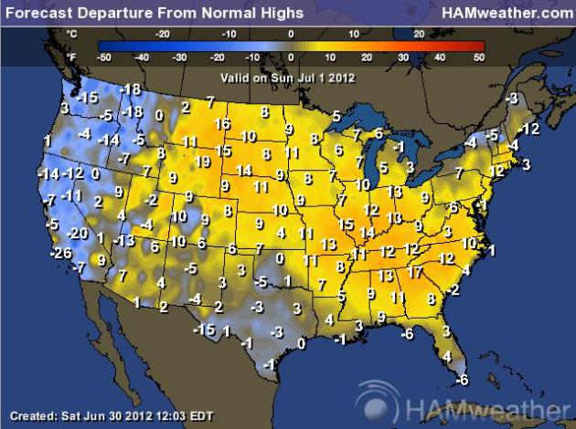
Highs From Normal
Sunday's high temperatures across the
eastern two-thirds of the nation will be well above average once again.
In some cases, temps will be nearly 20 degrees above average and at
record levels!
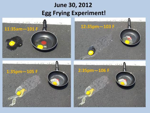
"It was so hot outside, you could fry an egg"
Every time the mercury rises, I think of a
song by Dave Matthews called Stay (Wasting Time)... In the song he
says, "We were walking just the other day. It was so hot outside, you
could fry an egg."
The National Weather Service out of
Huntsville, AL decided to try the egg frying on the last day of June
2012 as the temperature spiked into the 100s!
"Here are
the results of our egg frying experiment! We cracked the eggs at
11:35am and at 2:35 they were done! They were both done about the same
time with the pavement egg left with less egg whites."
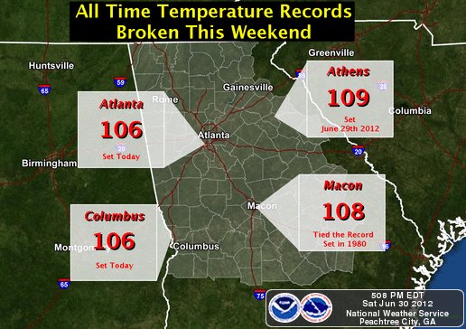
All-Time Temperature Records Broken This Weekend
These are some of the All-Time temperature records tied or broken this weekend in the state of Georgia!
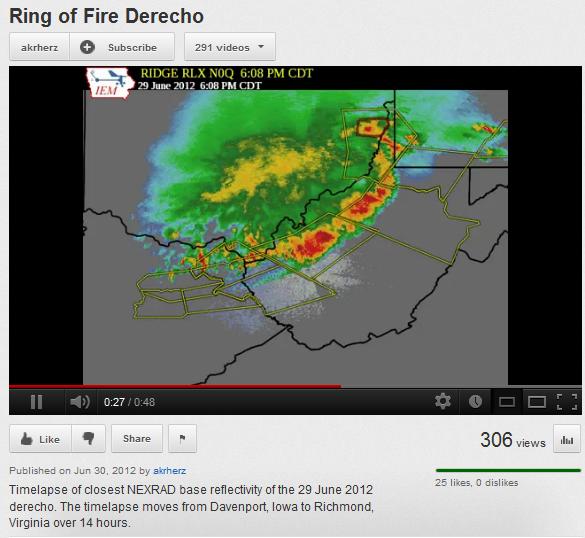
Summer Storms
On the northern periphery of this extreme
heat, storms tend to fire up. Saturday's "Derecho", responsible for
90+mph winds, was a classic example of these summer storms that feed off
of the extreme heat and humidity.
Youtube user: akrhertz put together a nice video of the Derecho that started near Davenport, IA and continued to Richmond, VA in over 14 hours.
A Leap Second?
I've heard of a Leap Year and a Leap Day, but this is the first time I've heard of a Leap Second!
"International timekeepers are adding
a second to the clock at midnight universal time Saturday, June 30,
going into July 1. That's 8 p.m. EDT Saturday. Universal time will be
11:59:59 and then the unusual reading of 11:59:60 before it hits
midnight."
"A combination of factors, including
Earth slowing down a bit from the tidal pull of the moon, and an atomic
clock that's a hair too fast, means that periodically timekeepers have
to synchronize the official atomic clocks, said Daniel Gambis, head of
the Earth Orientation Service in Paris that coordinates leap seconds."

Dry Weather in Flagstaff, AZ
This was from the Flagstaff, AZ National Weather Service...
"As long as there is no precipitation
at the Flagstaff airport today, then this will be the second most
number of consecutive days without precipitation. The last time the
airport recorded any precipitation was on April 26th! If the airport
does not receive precipitation through Thursday, then it will tie the
all-time record for the most consecutive days without precipitation."

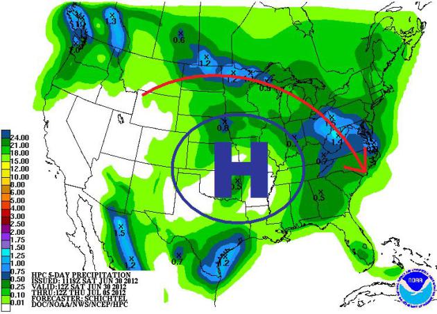
HPC 5-Day Rainfall Forecast
This is the 5-day rainfall forecast from
NOAA's HPC. Note that the heaviest precipitation is forecast to fall on
the northern periphery of the bubble of high pressure. Thunderstorms
will develop on the edge of the extreme heat, some of the thunderous
downpours could be locally heavy.
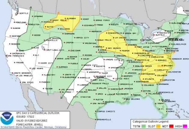
Sunday Severe Threat
Keep in mind that with as much heat and
humidity as there is... some of the storms could pack a punch! The Storm
Prediction Center has a SLIGHT RISK of severe weather on Sunday for the
areas in yellow.
Thanks for checking in and have a great rest of your weekend!
Don't forget to check me out on Twitter @TNelsonWNTV
-Meteorologist Todd Nelson-

No comments:
Post a Comment