MONDAY: Hot and very humid! Unsettled - a few heavy thunderstorms in the area. Dew point: 74. Heat Index: 100-105. High: 96
MONDAY NIGHT: Not much relief... scattered thunder, mainly north. Low: 77
TUESDAY: Heat wave continues. Unsettled, few lingering T-storms Dew point: 73. High: 95
4th Of JULY: Summer sizzle. Hot, hazy & humid. Whew... Slight chance of thunder late. Dew point: 74. Low: 75. High: 96
THURSDAY: Is it over yet? Sizzling. Some afternoon thunder possibe. Dew point: 74. Low: 77. High: 98
FRIDAY: Sweaty sun, chance of T-storms? Low: 76. High: 91
SATURDAY: Still warm, but slightly cooler. Low: 69. High: 88
SUNDAY: Another warm day, less humid. Low: Low: 67. High: 88
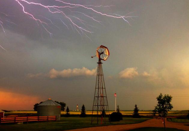
North Dakota Lightning
I happened to be out in North Dakota last
week for a family reunion/wedding. One of the days, we stopped at one
our family member's farm, beautiful place! This old windmill (which
still works as a water pump from the well below) was a perfect spot to
try some lightning photography... pretty lucky shot, huh?!
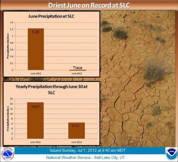
Salt Lake City Tied Driest June on Record
Hot and dry weather continues out west
and more records continue to fall. Salt Lake City, UT just had their
driest June on record with only a trace of precipitation.
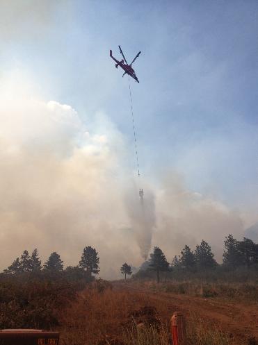
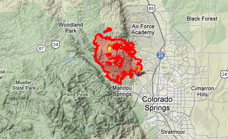
Wildfires Continue
There are still several wildfires ongoing out west. www.inciweb.org has the lastest:
"The Waldo Canyon Fire is the most destructive in Colorado history, with 346 homes lost.
Waldo Canyon started on June 23,
three miles west of Colorado Springs. Three days later, on June 26, it
exploded eastward toward the city, engulfing several neighborhoods.
Evacuations peaked on June 27 at 32,000.
On June 29, President Obama arrived
in Colorado Springs to visit burned neighborhoods, thank firefighters,
and visit a Red Cross evacuation center.
The cause of the fire remains under investigation."
The Waldo Canyon Fire has consumed nearly 18,000 acres and as of Sunday afternoon, it was 45% contained.
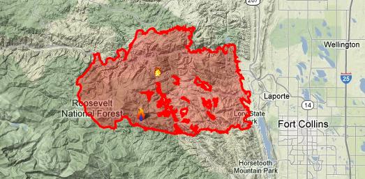
High Park Fire
The fire west of Fort Collins, CO has now been updated as 100% contained! Here's the latest from www.inciweb.org
"FIRE OVERVIEWContainment is now 100%. The Incident Command Post is located at the Pingree Park Campus. Fire crews are patrolling the fire perimeter, mopping-up hotspots near the edge of the fire perimeter, and conducting fire line rehabilitation, including chipping up fire line debris and slash and installing water bars to help prevent erosion."
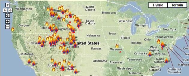
National Wildfires
This is a map of all the current
wildfires across the nation, the biggest of which is in southwest New
Mexico in the Gila National Forest. This wildfire is nearly 300,000
acres and is the largest wildfire in the state's history. The good news
is that it is 87% contained
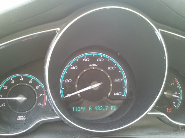
Extreme Heat Continues
Thanks to @mmarie1976 from Corbin, KY for
this picture. Not sure I've ever seen my car thermometer read 100F, but
113F... good grief!
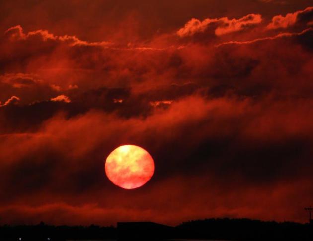
Perfect Lake Weather?
Thanks to Paul Douglas for this picture taken near Breezy Point on Pelican Lake...

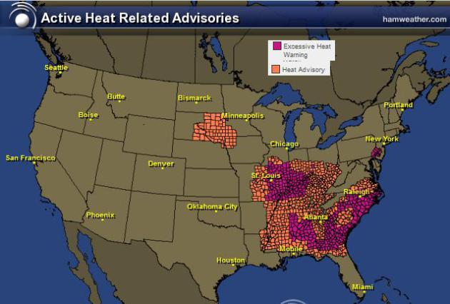
Excessive Heat Headlines
These
are all the heat advisories/excessive heat warnings that have been
issued by the National Weather Service. Heat index values in these areas
could top 100F... I expect to see more through the week ahead.
Heat Safety Tips
Serious Heat, Serious Problems
After Friday's massive wind storm (Derecho) from Davenport, IA to near Richmond, VA... there are still many without power and this extreme heat has folks really sweating it out!
"States declare emergency after storms leave at least 12 dead and millions without power
Powerful storms swept through the eastern United States Friday night, resulting in at least 12 deaths and leaving more than three million without power.
WASHINGTON – Utility crews untangled downed power lines and tree limbs Sunday, working to get the electricity turned back on for millions of people facing a second day of 100-degree temperatures without modern conveniences like air conditioning and refrigeration.
On Saturday, many people flocked to places like malls and movie theaters in the hope the lights would be on again when they returned home. Utilities were slowly making progress, but more than 3 million people still had no electricity and could only watch their thermostats climb. It could be several days before all the power outages are restored."
Duluth, MN
Thanks to my good friend, Rich Koivisto for the pictures above and below from Duluth, MN... Nice shots Rich!

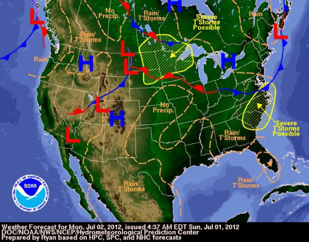
National Forecast For Monday, July 2nd, 2012
This
is the national forecast for Monday, July 2nd, 2012. Note how the
greatest severe thunderstorm chance is on the periphery of the extreme
heat.
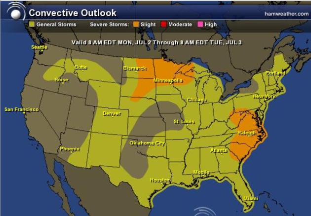
Monday Severe Threat
Thunderstorms
will bubble up on the periphery of the extreme heat, some of which
could be strong to severe. The Storm Prediction Center has issued a
SLIGHT RISK of severe weather for the areas in orange below. Hail and high winds will be the primary threat.
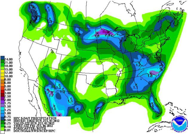
5 Day Rainfall
This
is the 5 day rainfall forecast from NOAA's HPC... pockets of heavy rain
will be accompanied with any thunderstorms that develop on outer edge
of the extreme heat.
Thanks for checking in, have a great week ahead!
Don't forget to check me out on Twitter @TNelsonWNTV

No comments:
Post a Comment