77 F. high on Sunday in the Twin Cities.
75 F. average high on June 3.
91 F. high on June 3, 2011.
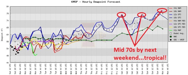
75 F dew points predicted for next weekend, meaning a tropical, uncomfortable airmass is 4-5 days away.
Warmest meteorological spring on record for the Twin Cities (dating back to 1873).
Second wettest meteorological spring on record (13.78" fell from March 1 through May 31, 5.87" wetter than average).
Smashing The Old Spring Record. Spring 2012 was 7.4 F. warmer than average, according to the
Minnesota Climatology Working Group. The two warmest springs in the Twin Cities have been observed since 2010.
A Quiet Week - Sauna-Like Sunday? Here are the
latest ECMWF (European) numbers, showing highs in the upper 70s to low
80s most of this week with only a slight chance of a Wednesday T-shower.
It's early, but Saturday looks like the wetter day of the weekend with
heavy T-storms, as a warm front surges northward. By Sunday highs may
top 90, a better chance of T-storms over central and northern Minnesota
and Wisconsin.
Enjoy the Good 'Ol (Comfortable) Days. Dew point, an
absolute measure of how much water is in the air, holds near 60 much of
this week, marginally humid but fairly tolerable. By the weekend dew
points are expected to reach the 70s...tropical weather is about 5 days
away. Make the most of the next few days...
"
As Climate Central reported
on May 23, the 2012 fire season is likely to continue the trend of
severe wildfire seasons in the Southwest, due largely to the prevalence
of long-term drought conditions in the region. Long-burning, massive
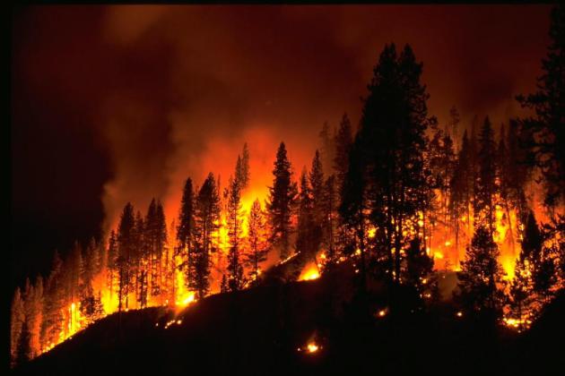
wildfires have become more common in the U.S. recent years." - details on the record blaze burning in southwestern New Mexico from Climate Central below. Photo courtesy of NOAA.
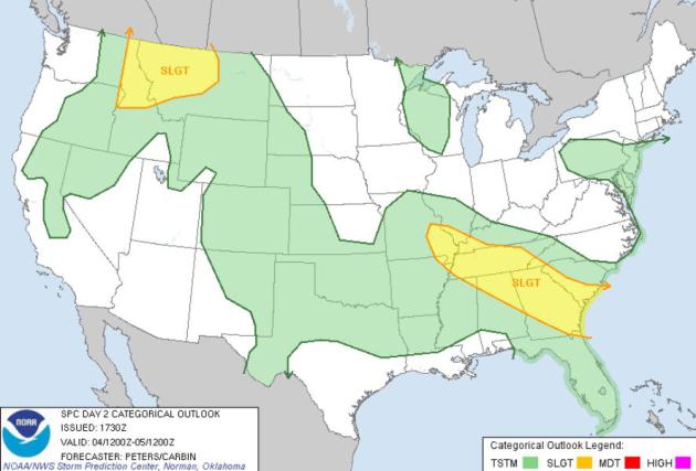
Partly-Severe. SPC is predicting a few severe
T-storms for Idaho and Montana, on the leading edge of unusually hot,
steamy air. Another band of rough weather may break out from the suburbs
of St. Louis to Memphis, Atlanta and Savannah.
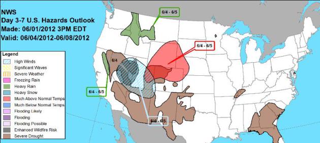
Day 3-7 Weather Threats. Here are NOAA's
major concerns
this week, ranging from significant heat from Denver northward into
Wyoming, highs winds for Salt Lake City and northern Arizona, heavy
rains for Idaho and Montana, and lingering drought for many southern
states.
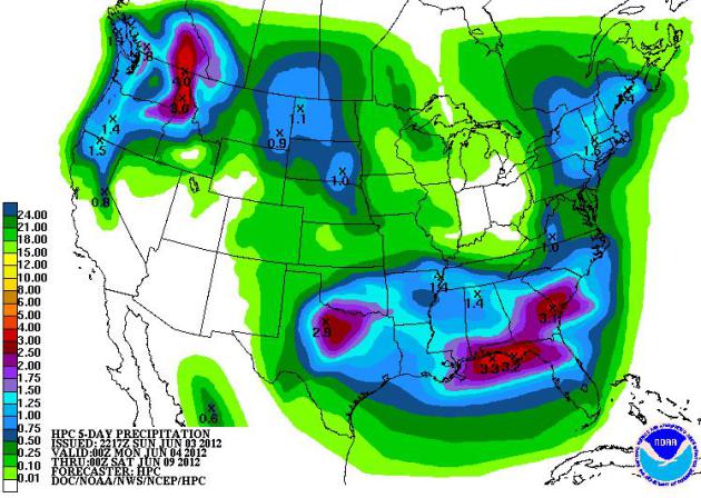
Rainfall Potential. A very soggy week is brewing for
the Pacific Northwest and much of the south, some 2-4" rains from Boise
to Dallas to the Florida Panhandle and Charleston. Map: NOAA.
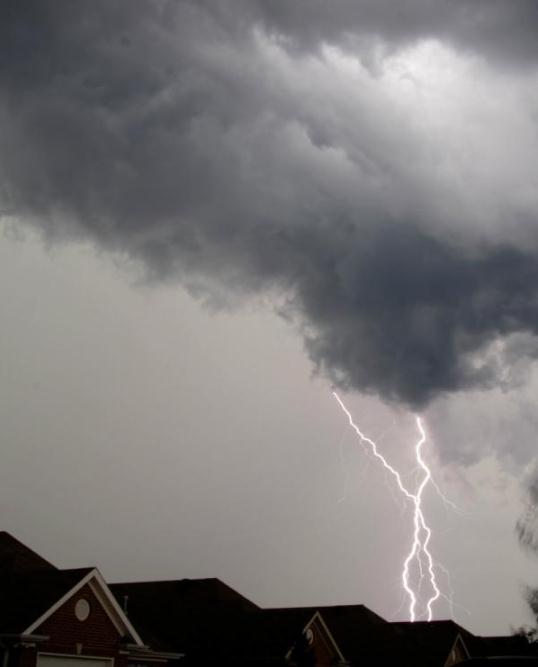
Wild Storms. Thanks to @rcoryjohnson, who snapped this shot in Fultondale, Alabama on Sunday.
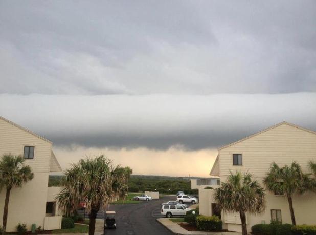
Roll Cloud. Severe thunderstorms rumbled through St. Augustine, Florida yesterday. Photo courtesy of Karen Nelson.
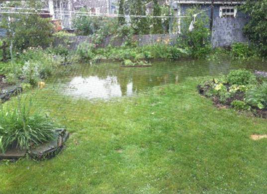
Flooded Yards. Robert Denton snapped this photo in
his backyard in Portland, Maine. Some 2-3" rainfall amounts soaked New
England over the weekend from an unusually slow-moving storm.
 180 Hour Forecast
.
Unusually cool, stormy weather grips the Pacific Northwest, while heat
builds across the Rockies and Plains by late week. Strong/severe storms
break out across the Deep South. No tropical storm development is
expected this week. GFS outlook courtesy of NOAA.
Record-Setting Blaze In Isolated Area Of Southwestern New Mexico Grows To Nearly 340 Square Miles.
It's already New Mexico's largest blaze on record, and it continues to
grow in size and intensity. Here's an update from AP and
The Washington Post: "
RESERVE,
N.M. — A wildfire burning in what New Mexico’s governor called
“impossible” terrain in an isolated, mountainous area of the state
continued its rapid growth Friday as forecasters called for
thunderstorms and dry lightning that could spark even more fires. The
massive blaze in the Gila National Forest in southwestern New Mexico is
the biggest in state history and the largest currently burning in the
country. It scorched an additional 39 square miles in the past day,
growing to nearly 340 square miles, as more than 1,200 firefighters
worked to halt its spread."
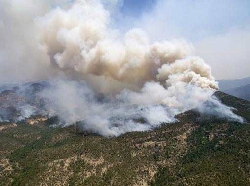
Photo credit above: "
In this Saturday, June 2, 2012 photo
provided by the U.S. Forest Service, a large cloud of smoke rises from a
fire in the Gila National Forest in New Mexico. The Whitewater-Baldy
Complex fire has scorched more than 377 square miles. (AP Photo/U.S.
Forest Service, Kari Greer)."
New Mexico Wildfires Now A Record-Setting "Megafire". Here's some perspective from meteorologist Andrew Freedman at
Climate Central: "...
The
megafire is the result of a merger of two separate, relatively
modest-sized fires. When the two merged in late May, the fire
dramatically expanded, burning 70,000 acres in just one day. As of
Friday, the fire had burned 216,000 acres, and was only 10 percent
contained. More than 1,200 personnel were battling the fire. There have
been no fatalities or major injuries. The fire has surpassed New
Mexico’s record fire, which occurred just last year. The Las Conchas fire burned more than 156,000 acres and came perilously close to Los Alamos National Laboratory, the birthplace of the atomic bomb."
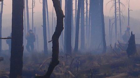
Photo credit above: "
Firefighters work burnout operations at the Gila National Forest." Credit: U.S. Forest Service.
Be Ready To Go; Hurricane Season Is Here Again.
Without an El Nino pattern to increase winds over the tropics (which
tends to weaken developing storms over the Atlantic and Caribbean), and
with water temperatures running 1-3 F. warmer than average, I suspect an
above-average year for hurricanes is brewing. Here's an excerpt of a
good article from
Longboat Key News: "...
Being
involved in evacuations with Sarasota County there were residents on
Siesta Key that refused to leave their home when we strongly encouraged
them to do so only later to find them calling the 9-1-1 Center asking
for the fire department to get them out of their home. The safety of
emergency workers is also at the top of the list and we do not go out
of our shelter when winds are sustained at 46 MPH. Evacuate early!
Our population must take evacuation seriously.
If you haven’t thought about hurricane preparedness than here is what is suggested:
1. Make a plan as to where you will go. Go to www.floridadisater.org
2. Contact Manatee or Sarasota County Emergency Management or Longboat Key Fire Rescue for a Hurricane Guide.
3. Develop a Disaster Supply Kit
4. Protect your home before the storm
5. Purchase a battery operated weather radio"
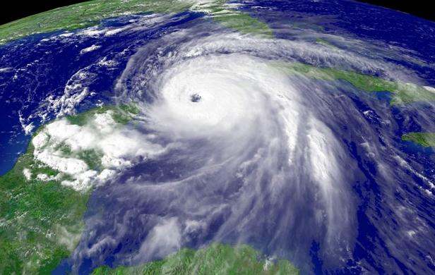
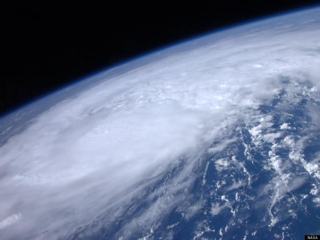
* Image above courtesy of NASA.
NASA To Fly Drone Aircraft Above 2012 Hurricanes.
NOAA NHC forecasters do a remarkably good job predicting hurricane
tracks. But forecasting hurricane intensity ("will Hurricane Bubba be a
Category1 or a Category 3 storm when it reaches land?") is much tougher
to pin down - models do a consistently poor job predicting intensity. It
turns out technology originally developed for the military has
potentially life-saving applications.
Brevardtimes.com has the fascinating details; here's an excerpt: "
Beginning
this summer and over the next several years, NASA will be sending
unmanned aircraft dubbed "severe storm sentinels" above stormy skies to
help researchers and forecasters uncover information about hurricane
formation and intensity changes. Several NASA centers are joining
federal and university partners in the Hurricane and Severe Storm
Sentinel (HS3) airborne mission targeted to investigate the processes
that underlie hurricane formation and intensity changes in the Atlantic
Ocean basin."
Hurricane Prep 2012: Answers From The Storm Experts. Here's an excerpt of an interesting post from
al.com:
Has there ever been an attempt or experiment to reduce the strength of a hurricane?
"
The U.S. government once supported research into methods of
hurricane modification, known as Project Stormfury. For a couple
decades the National Oceanic and Atmospheric Administration and its
predecessor tried to weaken hurricanes by dropping silver iodide -- a
substance that serves as a effective ice nuclei -- into the rain bands
of the storms. During the Stormfury years, scientists seeded clouds in
Hurricanes Esther (1961), Beulah (1963), Debbie (1969), and Ginger
(1971). The experiments took place over the open Atlantic far from
land. The seeding targeted convective clouds just outside the hurricane
eyewall in an attempt to form a new ring of clouds that, it was hoped,
would compete with the natural circulation of the storm and weaken it."
* Hurricane Irene image courtesy of NASA.
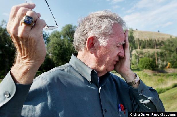
Memories Sharp, Emotions Strong For Those Who Lived Through 1972 Flood. A look back at what may have been a 1-in-500 year flood from
The Rapid City Journal; here's an excerpt: "
Tears
glistened in Don Barnett’s eyes as he stood on the city bike path near
Rapid Creek and remembered the horrors of that night 40 years earlier.
There, just downstream from the Omaha Street bridge, a woman who had
been swept down in raging flood waters from somewhere upstream was
clinging to a tree as a rope crew with the South Dakota National Guard
tried to save her. They could not. “Oh, it was so bad down here. The
water was so deep and fast, and it was so cold,” said Barnett, who was
Rapid City’s 29-year-old mayor on June 9, 1972, the night the flood
hit. “A young guardsman got to within 10 or 12 feet of that woman, and
then she just couldn’t hold on. And she was gone. And he was
devastated. That’s when I knew it was going to get bad.”
Photo credit above: "
Don Barnett was mayor of Rapid City
during the 1972 flood. Barnett is seen here along a bank of Rapid Creek
where he recalls a scene from that historic night." Photo: Kristina Barker.
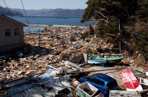
Japan City Could Watch Animals For Tsunami Signs. Here's an excerpt of an interesting story from
Yahoo News: "
A
Japanese city is considering introducing a tsunami warning system
which involves looking out for abnormal behaviour in animals and
monitoring water levels in wells for signs of an imminent disaster. The
southwestern coastal city of Susaki is contemplating studying whether a
rapid lowering of water in wells or chickens squawking loudly for no
apparent reason are indicators of an impending earthquake and tsunami.
"They may not foretell a future disaster in a perfectly accurate
manner, but the most important is to analyse such data thoroughly," said
deputy mayor Yoshihito Myojin, according to a regional broadcaster
late last month."
Photo credit above:
Yasuyoshi Chiba/AFP/File. "
A
general view shows tsunami damage in Onagawa, Miyagi prefecture in
2011. A Japanese city is considering introducing a tsunami warning
system which involves looking out for abnormal behaviour in animals and
monitoring water levels in wells for signs of an imminent disaster."
I Just Deleted All My Music. I don't know if this is
something you worry about, but I live in a constant state of perpetual
paranoia that all my data, family photos and important online documents
will get wiped out by a virus, a power outage or solar flare, or just
plain idiocy on my part. The "cloud" will save us? Not so sure. Anything
made my man can be broken. I've taken to using not only Apple's Time
Machine, but multiple hard drives to back up all my essential home
photos and movies - the stuff I would REALLY miss if I experienced a
massive computer failure. Do you back up your phones, tablets, laptops
and desktop systems religiously? Not to be a nag, but that old wise
proverb about "an ounce of prevention" really rings true with me. Here's
a cautionary tale from
NPR: "
I
just deleted over 25,000 songs from my iTunes library. I am going to
trust in the cloud, where my library now lives. I'm a bit scared, but I
backed everything up, took a deep breath and stepped into the future.
Abandoning the way I've come to listen to music over the last decade
feels like a big experiment, but in some ways, the decision was a long
time coming. I've been close to maxing out the hard drive space on my
laptop for a while, and in a single day this week, I reclaimed nearly
200 gigabytes."
Photo credit above: iStockphoto.com. "
Bob Boilen had more than 25,000 songs stored on his laptop's hard drive. Now there are none."
Sunday Numbers.
The clouds were more stubborn and prevalent than I thought they'd be,
keeping us a few degrees cooler than expected. Sunday highs ranged from
66 at Grand Marais to 77 in the Twin Cities, 78 St. Cloud and 79 at
Redwood Falls and International Falls. .08" of rain fell on Rochester
yesterday.
Paul's Conservation Minnesota Outlook for the Twin Cities and all of Minnesota:
TODAY: Partly sunny, dry. Winds: N 5-10. High: 82
MONDAY NIGHT: Mostly clear and mild. Low: 62
TUESDAY: Warm sun, feels like summer. High: 84
WEDNESDAY: More clouds, isolated T-shower possible. Low: 60. High: 77
THURSDAY: Sunny and pleasant. Low: 59. High: 81
FRIDAY: Hazy sun, warming up. Winds: S 15. Low: 63. High: 84
SATURDAY: Sticky & stormy. Tropical with a few heavy T-storms. Dew point: 65 Winds: SE 10. Low: 66. High: 83
SUNDAY: Steamy and hot. Storms north. Dew point: 70. Winds: S 10. Low: 69. High: 91
A Warm, Silver Lining
Now comes word from the
Minnesota Climatology Working Group that much of Minnesota just experienced the warmest spring on record. Accurate data goes back to 1873.
You don't have to like it, but our atmosphere is warming.
The western US is drying out with more
wildfires. In our lifetime a city like Las Vegas or Phoenix will
probably run out of water.
I'm still alarmed by the global trends, but
climate change may be a net-positive for Minnesota. In a century where
water is destined to become our most precious natural resource, we're in
good shape. The trends point to shorter winters (only 1 in 4 will be
"old fashioned" with average snow & cold), fewer subzero nights,
longer growing seasons, more rain, and more severe storms.
I'm still waiting for 3M to invent a hail-resistant film for my hybrid, btw....
Fortune 500 companies will have an easier time
luring fearful executives to MSP. I predict we'll be a Top 10 major
market by 2030. A northward migration is imminent. Wait for it. Talk
about a long-range prediction, but based on the trends I'm seeing that's
my extra-long-range outlook.
A dry, temperate week is on tap; nothing severe until next weekend, when a hot front sparks T-storms - 90s possible by Sunday.
Umbrellas optional for 5 days in a row? We've earned this weather-break!
Climate Stories...
Are We In The Midst Of A Sixth Mass Extinction?
"Honey, please pass me the sports page. Paul's on a rant about
extinction now - Monday's are tough enough." I realize this is tough to
read, but this book review in
The New York Times caught my eye on Sunday; here's an excerpt: "
NEARLY
20,000 species of animals and plants around the globe are considered
high risks for extinction in the wild. That’s according to the most
authoritative compilation of living things at risk — the so-called Red List maintained by the International Union for Conservation of Nature.
This should keep us awake at night.
By generalizing from the few groups that
we know fairly well — amphibians, birds and mammals — a study in the
journal Nature last year concluded that if all species listed as
threatened on the Red List were lost over the coming century, and that
rate of extinction continued, we would be on track to lose
three-quarters or more of all species within a few centuries."
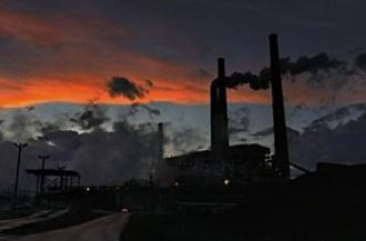
Why We Ignore Low-Tech Fixes For The Climate. Here's a thought-provoking piece from Ezra Klein's Wonkblog at
The Washington Post: "
Whenever
the conversation turns to greening the world’s energy supply, a lot of
the ideas tend to emphasize new and futuristic sources of power. Build
more wind turbines. Stack up more solar panels. Make sure fresh coal
plants don’t get built. But Catherine Wolfram, an economist at UC
Berkeley’s Haas School of Business, says that we too often ignore
simpler solutions, such as wringing more efficiency out of our existing
fossil-fuel and nuclear plants. Many of those power plants, after
all, are likely to stick around for decades to come. And there are
quite a few minor tweaks that can be made to these plants that can cut
greenhouse-gas emissions dramatically — tweaks that can have as much
impact as building hordes of new wind farms or solar panels."
Photo credit above: "A climate savior?" (Michael S. Williamson/The Washington Post)
Batterend By Erosion And Facing Global Warming, Some Places Are Moving Back From The Sea. Here's a clip of a story from AP and
The Chicago Tribune: "
LOS
ANGELES (AP) — Years of ferocious storms have threatened to gnaw away
the western tip of a popular beachfront park two hours drive north of
Los Angeles. Instead of building a 500-foot-long wooden defense next to
the pier to tame the tide, the latest thinking is to flee. Work is
under way to gauge the toll of ripping up parking lots on the highly
eroded west end of Goleta Beach County Park and moving a scenic bike
path and buried utility lines inland away from lapping waves. Up and
down the California coast, some communities are deciding it's not worth
trying to wall off the encroaching ocean. Until recently, the thought
of bowing to nature was almost unheard of."
 Global Warming Turns Tundra To Forest - Study
.
Reuters has the details: "
Plants and shrubs have colonised
parts of the Arctic tundra in recent decades growing into small
trees, a scientific study found, adding the change may lead to
an increase in global warming pressures if replicated on a wider
scale. Scientists from Finland and Oxford University investigated
an area of 100,000 square km, roughly the size of Iceland, in
the northwestern Eurasian tundra, stretching from western
Siberia to Finland. Using data from satellite imaging, fieldwork and
observations from local reindeer herders, they found that in
8-15 percent of the area willow and alder plants have grown to
over 2 metres in the last 30-40 years."
G.(reen) O.P. Here's an excerpt of a
New York Times Op-Ed from St. Louis Park native Thomas Friedman: "...
This
obsession with coal and oil strikes me as wrongheaded for three
reasons. First, there is a more intelligent conservative energy
strategy: a campaign to develop an energy mix that is “American,
diverse and clean.” Put the G.O.P. behind whatever fuel sources or
technologies the marketplace produces — be they natural gas, wind, wave,
solar, nuclear, efficiency, biofuels or sequestered coal — provided
they’re produced in America, give us diversity of supply and steadily
move us to cleaner air."
Politics Of Red, White And Green. Here's an excerpt of an Op-Ed from
The Boston Herald: "
It
was interesting while it lasted. But it looks like the “green
revolution” has entered the long slide into “What was all that about?”
In January, the Spanish government removed absurdly lavish subsidies
for its renewable energy industry, and the renewable energy industry all
but imploded. You could say it was never a renewable energy industry
at all. It was a government subsidy industry where in exchange for
creating conscience-soothing but other-wise inefficient windmills and
solar panels, the government gave the makers piles of cash consumers
never would."








No comments:
Post a Comment