83 F. high in the Twin Cities yesterday.
76 F. average high for June 5.
84 F. high temperature last year, on June 5, 2011.
Dry Wednesday on tap, highs topping 80 with more sun than clouds.
Slight severe risk Friday - best chance late afternoon into the early nighttime hours.
.14" rain predicted by Saturday morning in the Twin Cities (NAM model).
90+ highs still expected Saturday and Sunday.
 Dew Point Predictions:
Today:
58 F. (still fairly comfortable)
Thursday:
62 F. (humid)
Friday:
66 F. (very humid)
Saturday:
71 F. (tropical)
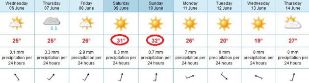 On Track For 90+ This Weekend
. The ECMWF has been consistent, and I'm still leaning more toward the European model than the U.S. GFS
model
(which is predicting 88 Saturday and 87 Sunday). I've discovered (the
hard way) that the ECMWF tends to do a better job looking 3-7 days out.
It's far from perfect, but it's helped me nail the last couple of heat
spikes at MSP. We'll see how it does this time around, but it still
looks like a good weekend for the lake or pool.
Transit Of Venus. No, I didn't have the equipment to
safely stare up at the sun yesterday evening, so I had to rely on the
good men and women at NASA (via
Facebook), who did the heavy lifting for me: "
A beautiful image from our Flickr group! Post your pictures of the Venus Transit at http://www.flickr.com/groups/venustransit/pool/."
"
According to historical records from the National Weather
Service, the last time that two Atlantic storms were formed before June
1 was in 1908. The only other year that two storms formed before the
official start of the hurricane season was in 1887." - excerpt of a
story at allvoices.com focused on the early start to hurricane season,
and new technology that may help to improve hurricane track/intensity
predictions. Details below.
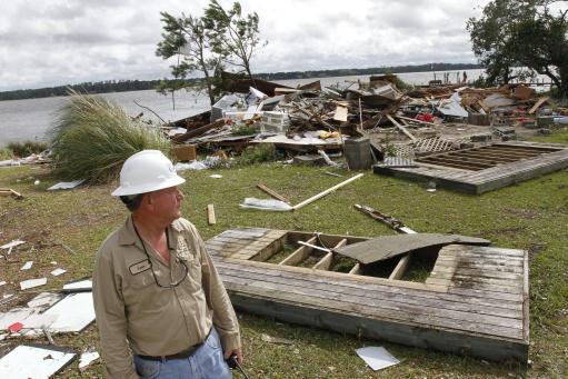
Photo credit above: "
Leon Whaley of Carteret-Craven
Electric Cooperative watches as others work to restore power after the
remnants of Tropical Storm Beryl spun off a tornado that destroyed
homes and damages dozens of others in the Pelletier community near
Swansboro, NC on Wednesday, May 30, 2012." (AP Photo/Tom Copeland)
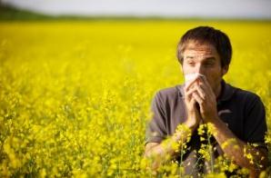
Asthma By The Numbers. We're suffering through a
mini-epidemic of asthma: perception or reality? It sure seems like more
Americans than ever are sneezing and wheezing; the
New York Times has the story: "
Federal health officials recently issued a gloomy report
noting that the percentage of Americans suffering from asthma reached a
record high of 8.4 percent in 2010, up from 7.3 percent in 2001. An
estimated 25.7 million people had asthma in 2010, including 18.7 million
adults and seven million children below the age of 18. It is a
frightening disease in which sufferers struggle to breathe. In severe
attacks, victims can die. Experts don’t know for sure what causes
asthma, but sounder public policy could help control some of the
triggers. Stronger regulations to reduce exposure to cigarette smoke
and to control air pollution are especially important."
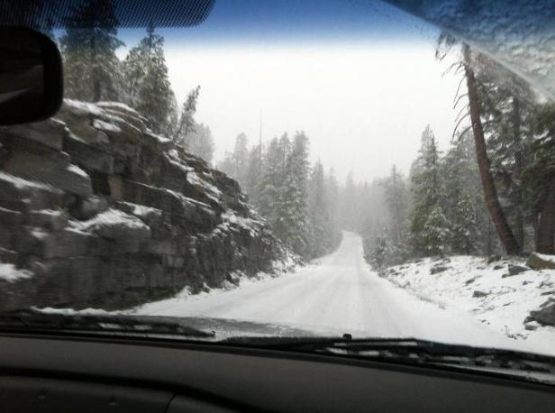
Nothing More Refreshing Than A June Snowfall. Good
grief: heavy, wet snow is falling on the highest elevations of
California and the Pacific Northwest. Hard to believe the summer
solstice is roughly 2 weeks away. Details from Yosemite National Park
via
Facebook: "
This
is a photo from the Tioga Road near White Wolf yesterday afternoon. We
got a bit of higher-elevation snow (and about 6/10 of an inch of rain
in Yosemite Valley). (The Tioga and Glacier Point Roads were closed
overnight but reopened this morning.)"
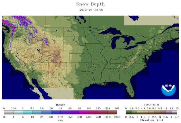 Winter Flashback
. It seems a bit odd to be showing a snowcover map (NOAA's
National Snow Analyses)
on June 6, about 2 weeks before the summer solstice. Flurries were
reported yesterday as far south as Elko, Nevada. As much as 10-80" of
snow remains on the highest peaks of the Cascade Range and northern
Rockies. Meanwhile extreme heat will push from the Intermountain Region into the Plains and Upper Midwest by the weekend.
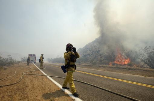
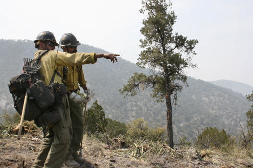
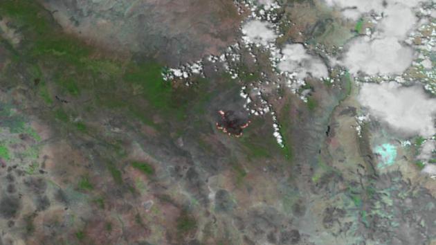 Whitewater-Baldy Complex Fire In New Mexico
. Here's the latest from NOAA's Environmental Visualization Laboratory: "
The Whitewater-Baldy Complex fire
is up to 259,025 acres burned. Aerial ignitions along multiple portions
of the fire boundary were carried out yesterday, June 4, 2012. This
image was taken by the VIIRS instrument aboard the Suomi NPP
spacecraft at 2015Z on June 4, 2012. The image combines high resolution
bands 3, 2 and 1 to make the colored land areas and clouds."
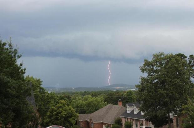
A 105% Probability Of A T-storm. Here is a photo of the thunderstorm
that swept across Little Rock, Arkansas on June 4, courtesy of the
Little Rock National Weather Service Office: "
This photo was taken by Chris McCrillis on the afternoon of June 4th as the storms moved into west Little Rock."
Nine Tornadoes In One Storm Not A Record For Maryland. Here's an excerpt from
wbal.com:
"Nine confirmed tornadoes as determined by the National Weather Service
investigators from Friday's storms, but that's not the most ever seeni n
the state during one storm. There were 35 confirmed with Hurricane Ivan
in 2004, the most on record, Howard Silverman of the National Weather
Service said. Ivan left more than a dozen people hurt in Maryland."
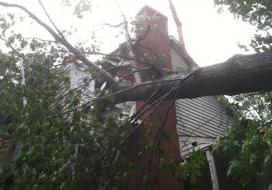
Photo credit: "
High winds tossed a tree into a home in Finksburg on Friday." (Photo submitted to WBAL News).
Social Media As A Tool In Flow Of Storm Information.
Increasingly storm spotters (and the general public) are using social
media to send in storm reports, especially twitter. Here's a snippet of
an interesting article at
jacksonville.com: "
From
Facebook updates on severe weather to mobile apps directing victims to
shelters during times of disaster, social media are becoming an
integral part of emergency preparedness and response. Relief groups such
as the Red Cross and local government emergency response departments
are increasingly using the power of social media to disseminate
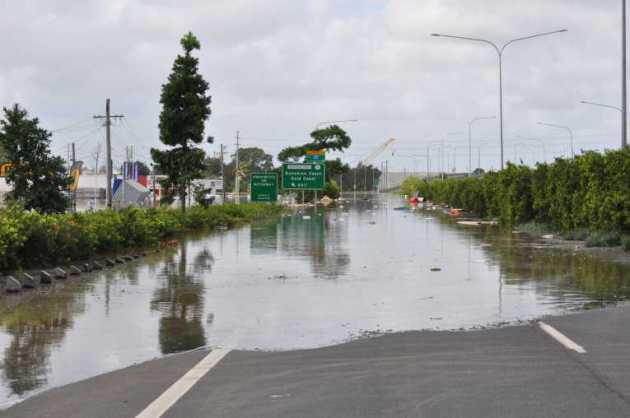
potentially lifesaving information when disaster strikes. When Tropical Storm Beryl
began dumping the first inches of what turned out to be more than a
foot of rain on Northeast Florida last week, Jacksonville's National
Weather Service used Facebook to provide information to residents. It
included where to find official forecast resources, maps and weather
condition updates."
Photo credit above: BRUCE LIPSKY/The Times-Union. "
The Times-Union sent out more than 500 tweets during the storm from Sunday morning to Monday evening."
Clean Up From 2011 Flood Continues. Hopefully we won't have a year like last year.
Cattlenetwork.com has some interesting details: "
The
flooding along the Missouri and Mississippi Rivers in 2011 left many
farmers struggling to recover. In 2012, many are still cleaning up the
mess and working to restore their cropland to productive levels seen
before the flooding. The flooding caused many corn and soybean fields to
become so damaged, that restoring the land will likely take multiple
years. “We’ll be working on this for years,” Mason Hansen, corn and
soybean farmer in Missouri Valley, Iowa, told the Des Moines Register.
“It’ll never be right. Ever. People don’t have any idea how big of a
mess this is.” Hansen told the Des Moines Register that he has spent
the past nine months removing sand from his crop fields and filling in
holes gouged out by the flood. He has cleared 140 acres of the sand,
but he still has 160 acres more to go."
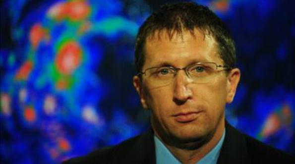
New Hurricane Director: Florida's Good Fortune Won't Last.
It's been 8 years since Florida suffered a direct hit from a hurricane -
there is growing fear that Floridians are becoming increasingly
apathetic. Some sage advice from the new Hurricane Center Director,
courtesy of a story and video at
The Sun-Sentinel: "
The new director of the National Hurricane Center
has a message for residents: Don’t assume Florida’s good fortune, six
years without a hurricane strike, will continue. “Someone is going to
get the next major hurricane, and you have to be prepared,” Rick Knabb
said on Tuesday. “It’s not a matter of if but a matter of when.” Knabb,
43, of Weston, is a veteran tropical forecaster, most recently the
hurricane expert for The Weather Channel and previously a hurricane specialist for the hurricane center."
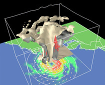
New Model Will Help NOAA Forecasters Study The Eyewall Of Hurricanes This Year. The story from
KATC.com in Lafayette, Louisiana - here's an excerpt: "
When
the first hurricane emerges from the Atlantic Ocean or Gulf of Mexico
this season, NOAA will use a new statistical model to help predict the
start of the "eyewall replacement cycle," a key indicator that a
storm's strength and size is about to change dramatically. This new
tool adds to a suite of forecast products NOAA uses to warn coastal
communities of imminent threats. An eyewall is an organized band of
clouds that immediately surround the center, or eye, of a hurricane.
The most intense winds and rainfall occur near the eyewall."
Photo credit above: NOAA.
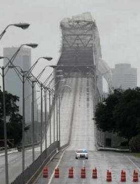
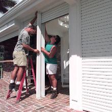
Hurricane Shutters Are On The Front-Line In Hurricane Defense. Here's some good advice from
The Miami Herald: "
If
your home isn’t secured with a shutter system, now is the time to move
this item to the top of your to-do list. Shutters are important not
only to protect your windows from flying debris but also to prevent
your home from being breached with hurricane-force winds if a window
breaks. When the wind gets in your home, it places intense pressure on
interior walls and can lead to a roof collapse. Commercially installed
shutters generally average $9 to $30 per square foot, according to the
Insurance Institute for Business and Home Safety. For
do-it-yourselfers, the cost is about 50 percent less per square foot."
Photo credit above: "
Installation: Workmen John Morales and Bruno Koti install Rolladen shutters at a Isle of Bahia home." LOU TOMAN/Sun Sentinel LOU TOMAN / Sun Sentinel.
Read more here: http://www.miamiherald.com/2012/05/30/2833912/hurricane-shutters-are-on-the.html#storylink=cpy
Read more here: http://www.miamiherald.com/2012/05/30/2833912/hurricane-shutters-are-on-the.html#storylink=cpy
Text, Don't Call When Natural Disaster Strikes.
Reuters has the story; here's an excerpt: "
It
is better to send text messages than to call when natural disasters
strike and networks get congested, a senior U.S. official said on
Wednesday, also urging people to add battery-powered cell phone
chargers to their storm emergency kits. Craig
Fugate, head of the Federal Emergency Management Agency, told
reporters that forecasts for a "normal" Atlantic hurricane season
should not keep those in potentially affected areas from getting ready
for storms that could make landfall.
"There is no forecast yet that says where they are going to hit or not
hit. So if you live along the Gulf Coast, the Atlantic, and as far
inland as the folks in Vermont found out last year, you need to be
prepared for this hurricane season," Fugate said at a White House news
briefing." (Photo above: NASA).
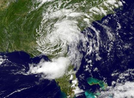
Early Start To Predicting Near-Normal Hurricane Season
According To NOAA Forecasters: Two Models Improve Forecaster's Ability
To Predict Storm Track and Intensity. O.K. This article gets top honors for "longest headline", but there are some interesting nuggets in this story from
allvoices.com: "
(Miami,
Fl) Despite forecasters predicting a “near-normal” 2012 hurricane
season, it is already off to an early start even before the June 1
official start date. Two tropical cyclones have already formed in the
Atlantic prior to June 1, the first, Tropical Storm Alberto formed off
the coast of South Carolina on May 19 and remained off the east coast
of the United States until it weakened and was no longer considered a
tropical cyclone by the National Hurricane Center on May 22. Tropical
Storm Beryl was first recognized as a tropical depression on May 25 at
11:00 P.M. by the National Hurricane Center off the Florida coast and
made landfall as a Tropical Storm with winds estimated at 70 mph near
Jacksonville Beach, Fl. shortly after 12:00 A.M. on Memorial Day." (Image above: NOAA).
Cal Fire Officials Anticipating A Busy Fire Season. A
lack of rain across the Southwest has many officials concerned about an
extra-severe fire season. Here's an excerpt of a story from
firehouse.com: "
The
central Sierra Nevada had a relatively calm fire season last year, but
an unusually dry winter and a December wind storm that blew down many
large trees has Cal Fire officials anticipating a busy summer for
wildfires. Several late spring storms brought some much-needed rain to
the Northern San Joaquin Valley and snow to the Sierra, helping to
lessen the fire threat. The weather, however, has returned to its
normal dry pattern for this time of year. The vegetation is drying up
and becoming fuel for a blaze, said Battalion Chief Barry Rudolph of
the Tuolumne-Calaveras unit of the California Department of Forestry
and Fire Protection." (May 25, 2012 fire image courtesy of Gregory Bull from AP).
TV: An Intervention. Remember when you had to
purchase an entire "album" to get the one track you really wanted to
listen to? TV is coming up to an inflection point, a moment of truth.
Increasingly, many viewers are spurning cable and satellite ("why pay
for 400 channels when I only watch a dozen on a regular basis?") This
"unbundling" effort is gaining steam. Only pay for what you watch. Makes
sense, right? It may to you and me, but it will create an ugly
revolution in the television industry and change the way shows are
financed. Here's a story from
Huffington Post: "
I've
complained numerous times in this space about the endless claims from
media pundits that "TV is dying." Despite pronouncements by experts
like David Carr and miscounted viewership by Nielsen, I can assure you,
TV IS NOT DYING. That said, despite a current heyday of creativity and
originality -- Television does have something wrong with it. Yes, as
Carr pointed out and Nielsen reported, "traditional TV viewing" has eroded. However, it has not been replaced by something other than TV, it's been replaced by more TV, just on other platforms. In some cases, those other platforms are legal; in other cases they are not. As Brian Stelter demonstrated last week, many twenty-somethings are using their parents' HBO GO account to watch Girls, without a TV. As TorrentFreak points out, many others are simply stealing TV."
Photo credit above:
techpinions.com.
What Is "SmartGlass"? Microsoft is showing it's
R&D chops here - some pretty interesting interactivity will be
possible between the big (TV) screen and the smaller screen on your lap.
Gizmag.com explains: "
Microsoft
used its E3 press conference to unveil its new SmartGlass technology
that will use handheld devices such as smartphones and tablets as both
an Xbox control device and as a second screen for the display of
dynamic, rich information. Head of Xbox Live, Marc Whitten, confirmed
that in additional to working with Windows 8 phones and tablets,
SmartGlass would be compatible with iPhone, iPad and Android devices.
The technology will finally see the arrival of Microsoft's Internet
Explorer web browser to the Xbox 360 before the end of the year."
Epic Fails. Thanks to failblog.org for sharing these. Math (and spelling) seem to be ongoing challenges for many in our midst.

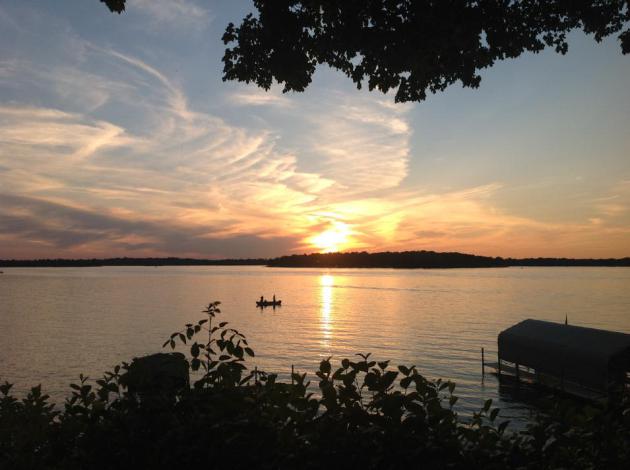
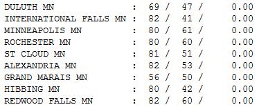 Pretty Close To Perfect
.
In case you slept in 'til the crack of sunset, or were in a
self-induced food coma yesterday, the weather was extraordinary. A cool
breeze blowing off Lake Superiod kept Grand Marais residents reaching
for jackets; a high of only 56 (69 at Duluth, up on the hill). Elsewhere
highs ranged from 81 at St. Cloud to 83 in the Twin Cities.
"If I find in myself desires which nothing in
this world can satisfy, the only logical explanation is that I was made
for another world.” – C.S. Lewis
Paul's Conservation Minnesota Outlook for the Twin Cities and all of Minnesota
TODAY: Partly sunny, probably dry. A pleasant June day. Winds: SE 10-15. High: 81
WEDNESDAY NIGHT: More clouds, slight chance of thunder late. Low: 63
THURSDAY: Sticky, few T-storms around town. High: 82
FRIDAY: Muggy. Strong T-storms (best chance central and northern MN). Winds: S 15. Low: 66. High: 86
SATURDAY: Hot sun. Feels like 98. Dew point: 72 Winds: S 15. Low: 68. High: 93
SUNDAY: Very lake and pool-worthy. Hot sun, sauna-like. Dew point: 73. Winds: S 10-20. Heat Index: 96-100). High: 95
MONDAY: Storms early, then clearing - turning less humid. Low: 67. High: 82
TUESDAY: Sunny, cooler, comfortable again. Low: 62. High: 76

Weekend Hot Front
I know I can get news on the web, tablets and
smart phones (soon on my dental fillings) but I'm still partial to
newspapers. And no, the Star Tribune didn't put me up to this. Holding a
paper, picking and choosing the stories that strike a nerve - is a
different animal than grazing a web site. There's something reassuring
and comforting about the feel of paper.
When I was 12 years old
I'd cut out the weather page of the Lancaster New Era newspaper,
scribble my own forecast next to it and come back the next day to see
how I did. I had notebooks full of "busted" forecasts.
The college degree is great but the only way to
learn how to predict the weather is trial and error. It's a painful
learning curve, a 3-D crossword puzzle, a rewarding and humbling way to
make a living. The best forecasts use computers AND human intuition. Not
sure we'll ever have Google iRobots reading us the 7-Day. Sure hope
not.
Today looks dry but the approach of tropical air
sets off T-storms Thursday and Friday; a tiny percentage may turn
severe. I'm still hanging my hat on the European ECMWF model, predicting
90s this weekend. Dew points in the 70s will make you want to go jump
in a lake.
Heat indices may approach 100F.
Lovely!
* photo above courtesy of
scrapetv.com.
Climate Stories...
Megafires, Record Heat And Drought. How Climate Change Is Affecting The Southwest. The story from
EcoWatch; here's a snippet: "
Huge and devastating wildfires are currently ravaging large expanses of the southwestern U.S.
As the Guardian reports, low intensity wildfires have always been part
of the landscape of the southwest, but a study by fire scientists last
month “charted a disturbing new trend of large and devastating fires, consuming record areas of land and burning for weeks.”
These “megafires” have become a regular summer occurrence in the
southwest “because of drought, climate change and human interference
with the natural landscape,” according to the Guardian.
New Mexico, for example, is currently experiencing the biggest fire in
state history. The fire, which started at the Whitewater-Baldy complex
in the southwestern part of the state, currently covers an area of 337
square miles."
Photo credit above: "
Crew members from the Granite
Mountain Hotshots of Prescott, Ariz., cut a fire line along a mountain
ridge outside Mogollon, N.M., Saturday, June 2, 2012, in an effort to
manage and contain the Whitewater-Baldy fire which has burned more than
354 square miles of the Gila National Forest in New Mexico. Unlike
last year's megafires in New Mexico and Arizona, this blaze is burning
in territory that has been frequently blackened under the watchful eye
of the Gila's fire managers." (AP Photo/U.S. Forest Service, Tara Ross)
Expert: Climate Change Will Increasingly Become Global Health Issue. Here's an excerpt from a report at U.S. News and World Report: "
Previously just the worry of climate scientists, environmentalists,
doomsday prognosticators, and gas-price watchers, climate change is
starting to worry some others— public health specialists, who say that
global warming could affect large swaths of the population. In a paper published in the journal PLoS Medicine Tuesday, a
group of European public health experts write that climate change could
alter "patterns of physical activity and food availability, and in some
cases [bring] direct physical harm." Slight temperature increases could
also change disease distribution in colder regions and make hotter
regions less hospitable to humans."
400 PPM: A Milestone That Means Everything, And Nothing. The story from
Climate Central: "
I’m
not big on taking note of milestones. They’re artificial, and usually
meaningless, but people get all worked up about them anyway. I don’t
like to stay up late on New Year’s Eve, for example, because Dec. 31 is
a purely arbitrary date. Nothing real actually begins the next day,
but we all pretend otherwise. I have similar feelings about the first day of spring,
the temperature reaching 100° as opposed to 99° and all sorts of other
magic-sounding dates and numbers that don’t have any real
significance. But since no law says I have to be consistent, I’m going
to take note of a milestone that happened some time in the past couple
of months, and which was reported last week
by NOAA. For the first time in recorded history, and almost certainly
for much longer than that, the atmosphere’s concentration of carbon
dioxide, or CO2, has nipped above 400 parts per million in at least one
part of the world. Monitoring stations in Alaska, northern Europe, and
Asia have all noted readings above that level during this past spring."
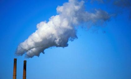
Geoengineering Efforts Against Climate Change Could Turn The Sky White. Well there's a lovely thought; details from
gizmodo.com: "
Scientists
have proposed injecting huge amounts of sulfate aerosols into the sky
as a way of reducing the effects of climate change. These scientists
also believe the particles could reflect away more sunlight, reducing
the direct sunlight which reaches the earth by 20 percent. New
Scientist writes: The blue colour of the clear sky comes from light
being scattering by molecules in the air. The scattering is much
stronger for short blue wavelengths than for longer red wavelengths."
What On Earth Is Happening To Canada? Answer: Black Out Speak Out. Here's an excerpt from
Huffington Post: "
June
4 is "Black Out Speak Out Day" in Canada. It's not a holiday. It's a
rare national day of protest against Prime Minister Stephen Harper's
conservative government's attack on civil society organizations
including labor, environment, immigration, and students. Over 13,000
Canadian websites will be blacked out in protest. Many U.S. groups,
including the Sierra Club, will join in solidarity. How did this happen
to our friendly neighbors to the north? Why did Harper become so
oppressive? Canadians pride themselves in being reasonable, open to
discussion, tolerant, process-oriented-a bastion of democracy. Harper's
attacks are happening for many reasons, not the least of which was the
success of environmental groups in Canada, the U.S. and Europe
threatening what Big Oil wants most: unlimited tar sands expansion and
pipelines like the Keystone XL to send its oil around the globe."
Photo credit above: "
Demonstrators hold up signs in front
of the White House in Washington, Friday, Sept. 2, 2011, to protest the
Keystone XL Pipeline project in the US, and the Tar Sands Development
in Alberta Canada." (AP Photo/Luis M. Alvarez)
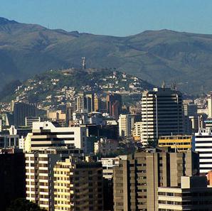
USA Trails Latin America And Asia In Climate Change Preparation. Some interesting stats in this article from
SciTechDaily.com; here's an excerpt: "
A
new survey from MIT is the first to systematically investigate the
efforts of cities around the globe to adapt to climate change, showing
that 95 percent of major cities in Latin America are planning for
climate change, compared to only 59 percent of such cities in the
United States. Quito, Ecuador, is not considered a global
leader by most measures. But there is one way in which Quito is at the
forefront of metropolises worldwide: in planning for climate change.
For more than a decade, officials in Ecuador’s mountainous capital have
been studying the effects of global warming on nearby melting
glaciers, developing ways of dealing with potential water shortages and
even organizing conferences on climate change for leaders of other
Latin American cities."
Photo credit above: "
Quito, Ecuador. Photo: wikimedia/Patricio Mena Vásconez."
Arctic Witnesses Climate Change. Here's an excerpt from
topnews.us: "
As per a report published in the journal Nature, it has been revealed that climate change is having disastrous effect on the Arctic. The report named as ‘Eurasian Arctic greening reveals that teleconnections and the potential for novel ecosystems’ was being studied by a group of researchers from the University
of Lapland, Finland, and Oxford University. The report was of the view
that they investigated an area which was around about 100,000 square
kilometers and stretched from western Sibera to Finland. First author
of the study Dr. Marc Macias-Fauria of Oxford University’s Department
of Zoology said that they studied vegetation pattern and after studying
the pattern, it was found that Salix and alder have increased by two
meters in size in last 2o to 40 years."


No comments:
Post a Comment