Exhibit A
By Paul Douglas
"Climate change is a bunch of
horse-hooey, just an excuse for scientists to get rich off all those
fat, government grants. Besides, a warmer Minnesota sounds pretty good,
huh?" How true, and the next time you see a climate scientist driving a
Ferrari into the lab give me a call.
A milder Minnesota does sound good on
some level. But a warmer atmosphere holds more moisture, loading the
dice in favor of more extreme rainfall events. 3 inch plus downpours
have doubled since 1961. Tell that to residents of Cannon Falls, where
10" rain fell Thursday evening. That's a SUMMER'S worth of rain, falling
in 8 hours. I think I'm going to need a bigger rain gauge.
Another precious weekend, and the
weather-news isn't all bad. A few hours of showers and thundershowers
are likely today, a drippy dew point nudging 70. A push of drier air
results in a (rare) sunny Father's Day. The only concern tomorrow will
be sunburn, as highs push into the mid-80s.
Early next week an atmospheric
tug-of-war plays out above Minnesota; 90-degree heat possible Monday,
again Wednesday, sparking more waves of strong to severe storms. Welcome
to Guam… with lakes.
At least we salvage a fine day for your dad.
____________________________________________________________________________________________
Todd's Conservation MN Outlook for the Twin Cities and all of Minnesota:SATURDAY: Wetter day of the weekend. Showers, possible thunder. Dew point: 68. Winds: SW 10. High: 81
SATURDAY NIGHT: Lingering showers or storms early with some clearing late. Low: 62
FATHERS DAY: Sunny and pleasant, risk of sunburn. Thunder developing overnight. Dew point: 55. Winds: SSW 10-15. High: 85
MONDAY: Hot, sticky, and unsettled with storm. Dew point: 65. Low: 69. High: 88
TUESDAY: Unsettled, more showers and T-storms. Low: 66. High: 84
WEDNESDAY: "Stinking hot". Some sun - Thundery up north. Low: 68. High: 88
THURSDAY: Front lingers with scattered thunderstorms, some strong?. Low: 67. High: 80
FRIDAY: Cooler, breezy and less humid. Lingering showers up north. Low: 60. High: 75
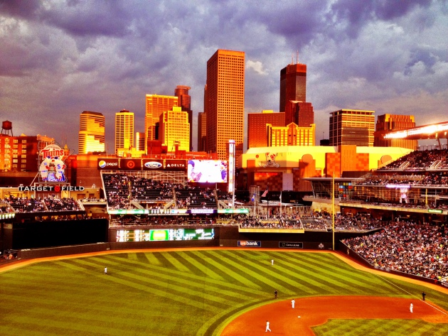
Baseball Weather
I had a chance to get to Target Field
Thursday night for the Twins vs. Phillies series and I'm still in awe of
the park! I can't go over how picturesque it is (no matter where your
are). Thunderstorms with flooding rains set up just south of the Twin
Cities, meanwhile the sun was peeking out across parts of the Metro.
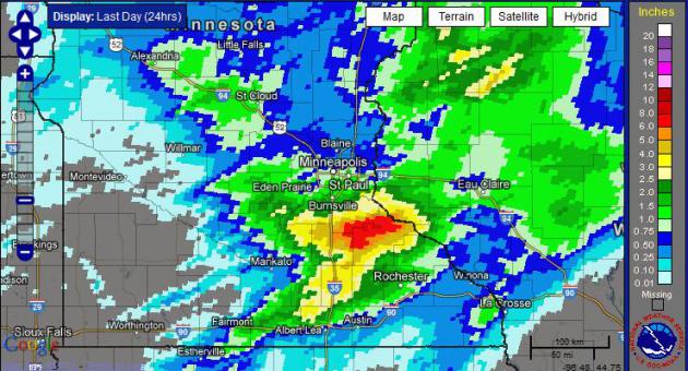
Thunderous Downpours
Look at the big red blob just south of the Twin Cities, that's from Thursday night's heavy (flooding) rain!
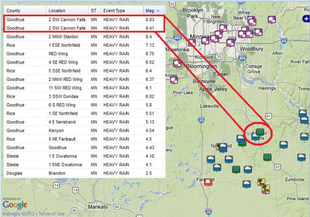
Rain Reports
Here are some of the actual rain reports from Thursday night...
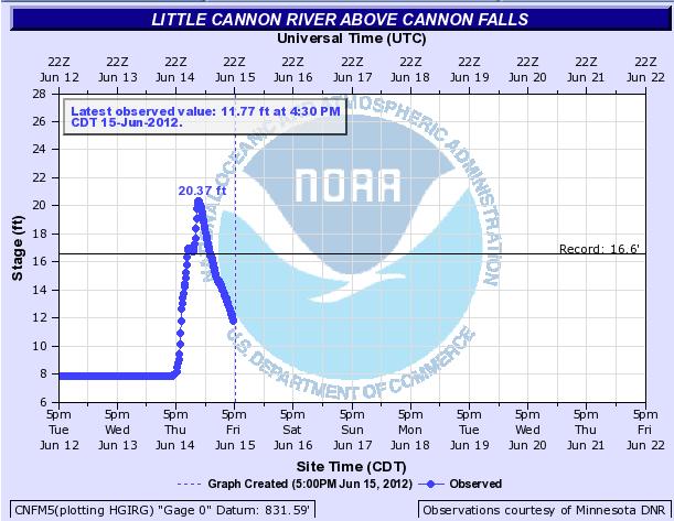
Incredible River Rise
This is a look at
the river gauge from on the Little Cannon River about Cannon Falls, note
the incredible river rise within a matter of hours... very scary! The
20.37' observed on the Little Cannon River early Friday morning becomes a
new record stage for that river gauge!
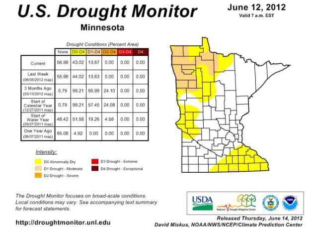
Minnesota Drought... Where'd It Go?
This is certainly
good to see! The U.S. Drought Monitor has it's new update on Thursday
with only 13% to 14% of the state under a MODERATE DROUGHT. This is
considerably better than 3 months ago when nearly 96% of the state was
under the moderate drought and around 24% of the state under a severe
drought (including parts of the Twin Cities. Thunderous downpours in May
and June have helped out tremendously! Minnesota lake levels have also
been reported to be on the rise.
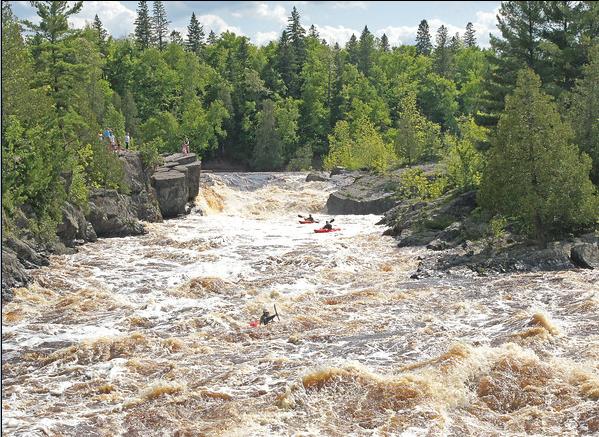
MN Lakes and Rivers on the Rise
Check out this
picture from a good friend of mine, Paul Sundberg, who snapped this shot
from Jay Cooke State Park in northeastern Minnesota. Read his
commentary below and check out his other spectacular photos at his
website:
"Along with some
friends I conducted two photo workshops this last weekend. One on
photographing birds and wildlife at the North House Folk School in
Grand Marais and the other on photographing wild flowers at Jay Cooke
State Park. But the excitement was not in the wildflowers due to the
huge amount of water coming through the St. Louis River gorge. I cannot
remember seeing this much water coming through Jay Cooke State Park.
Standing on the swinging bridge was incredible.
Some extreme kayakers came over the falls while the class was looking at the rapids. I could not imagine kayaking through rapids like that. As they came under the swinging bridge they had a very short margin of error to get themselves across the current and into the eddy where they could take their kayaks out of the river. I don’t think any kayaker could have continued beyond that point into the lower valley.
As the sun was setting some of us went to view the water coming out of the dam. The noise was like a huge freight train bearing down on you. The evening light made for some great slow motion shots of the water crashing over the rocks."
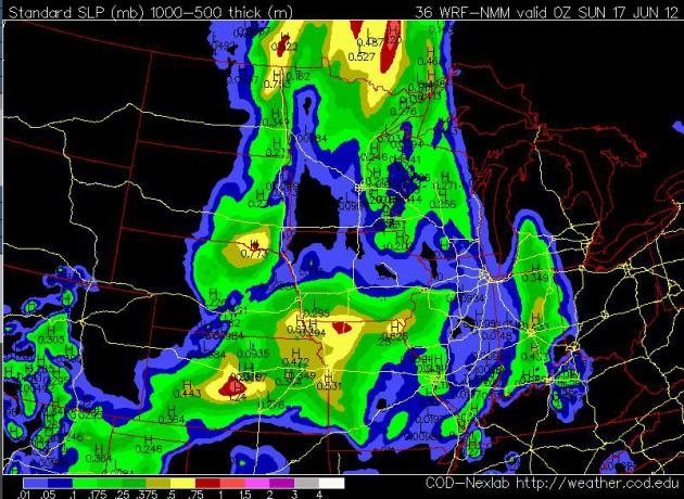
Somewhat Soggy Saturday
Weather forecasts
for Saturday look a little soggy... unfortunately for those
weddings/grad parties (or any other outdoor activities) we may have to
dodge a few rain drops/rumbles of thunder. The graphic below shows a few
more of the green and red blobs than what I would like to see.
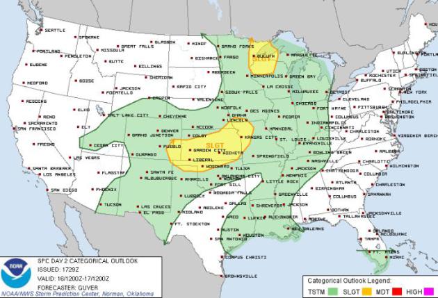
Saturday Severe Threat
The Storm Prediction
Center has parts of Minnesota and Wisconsin under a SLIGHT RISK of
severe weather for Saturday. The primary threat for Saturday's storms
would be hail and high winds... there may be a few watches or warnings
close to home Saturday afternoon, stay tuned.
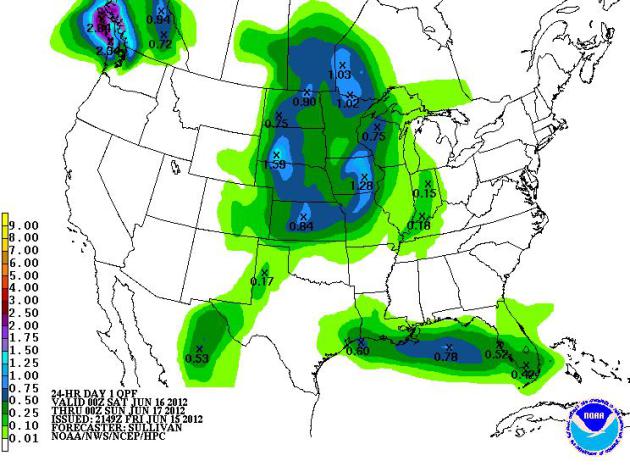
Rainfall Forecast
The HPC rainfall
forecast from 7pm Friday to 7pm Saturday suggests that parts of
Minnesota could see up to an additional 1" or more (in pockets where
thunderstorms develop).
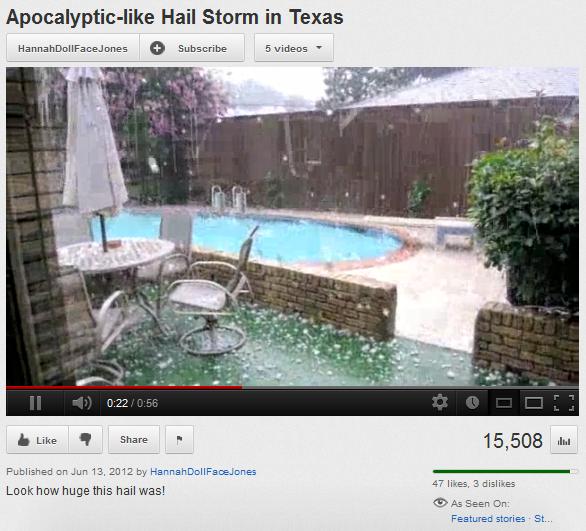
Big Dents in Dallas, TX
A massive hail storm in Dallas, TX earlier this week may result in several hundred millions dollars in insurance claims!
"The hail storms
were the worst in the North Texas and Dallas area since April 2003, the
National Weather Service said on Thursday. The storms likely
caused hundreds of millions of dollars in insured losses, and may even
top the $400 million in losses from a series of tornadoes two months
ago, the Insurance Council of Texas said on Thursday. No serious injuries were reported."
Soccer Match Halted Due to Thunderstorm
"DONETSK, Ukraine — The
Ukraine-France game at the European Championship was halted for nearly
an hour Friday because of a fierce thunderstorm.
Just five minutes into the game, Dutch referee Bjoern Kuipers
pointed upward and blew his whistle, signaling a rare stoppage for
weather. The players sprinted to the tunnel at Donbass Arena as
torrential rain poured and lightning flashed in the night sky."

Thanks for checking in and have a great weekend (Father's Day Weekend) Ahead!
Don't forget to follow me on Twitter @TNelsonWNTV
-Meteorologist Todd Nelson-

No comments:
Post a Comment