78 F. average high on June 13.
77 F. high on June 13, 2011.
Trace of rain reported at KMSP (Twin Cities International Airport) yesterday.
Friday, Sunday: two days with the best chance of seeing the sun in the coming days.

Slight severe storm risk today for the Twin Cities, St. Cloud, and much of central/southern Minnesota. Source: SPC.
.50" rain predicted for the Twin Cities today (00z NAM model).
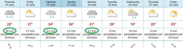
Watering Optional. OK. I've been ranting and raving about the European (ECMWF) model for weeks now, ad nauseum. It has done a better job, overall, than the (U.S.) GFS model looking out beyond 3-4 days. The ECMWF is hinting at Friday and Sunday as the sunniest, driest days in sight, but some very significant rain, coming every other day. Here are the predictions (converted from metric - millimeters - to inches):
1.5" Today
.17" Saturday
2.4" Monday
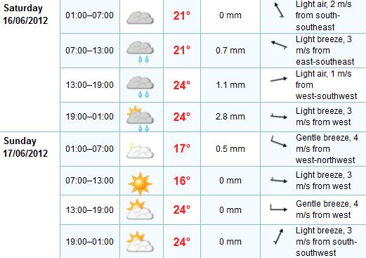
Weekend Details. Here is the detailed break-out of the weekend forecast, data provided by the ECMWF. Showers are likely Saturday (although not the soaking I feared a few days ago). A wind shift brings slightly drier air into Minnesota Saturday night and Sunday, highs on Fathers Day in the upper 70s and low 80s.
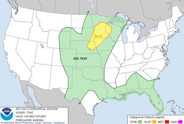
Severe Risk Today. SPC has a slight risk from Omaha and Sioux Falls into the Twin Cities, St. Cloud and Brainerd later today - expect watches and warnings in the slight risk area.
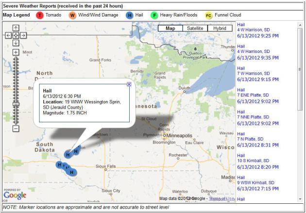
Latest Storm Reports. Here's a nice tool from NOAA, latest storm reports on an interactive Google map - in this case showing large hail that fell west of Sioux Falls, South Dakota Wednesday evening. Bookmark-worthy.
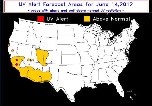
UV Alerts. NOAA has a new experimental product that highlights regions of the USA where UV (ultraviolet) radiation may reach dangerous levels. Keep in mind the sun overhead is as high in the sky as it ever gets over the Northern Hemisphere. The potential to tan (or burn) has nothing to do with air temperature, and everything to do with the date, the sun angle. Here's more information on UV Alerts from NOAA: "The UV Alert product is a joint venture between the NWS and the EPA to provide guidance for areas around the contiguous 48 states that are expected to experience well above normal UV radiation levels during the midday period. If you are within a UV Alert region extra precautions should be taken to protect oneself from the sun's UV radiation. Areas of above normal UV conditions are shaded (yellow), and areas expected to be "well above normal" conditions (red)."
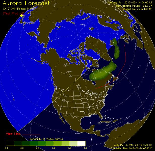
Risk Of An Aurora. With the sun heading into a more active phase (scheduled to peak in 2013) the odds of witnessing the Northern Lights (one of the more magical things you can see in the North Woods of Minnesota) may increase in the months to come. If you're looking for a good link showing real-time aurora potential, click here to see the latest Ovation Outlook, courtesy of NOAA (still an experimental product): "OVATION: An empirical model of the intensity of the aurora. The model uses solar wind conditions and the IMF at the L1 point as inputs. The Display: Shows the intensity and location of the aurora as expected for the time shown at the bottom of the map. This forecast is based on current solar wind conditions and the average time for the solar wind to propagate from the ACE satellite at L1 to Earth. The model produces an estimate of the intensity of the aurora. In this product a linear relationship between intensity and viewing probability is assumed. This relationship was validated by comparison with data from the UVI instrument on the NASA POLAR Satellite ."
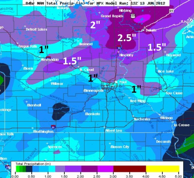
Bigger Puddles Up North. Here is the latest (NAM) rainfall prediction looking out 84 hours, over 1" for the metro (wetter north metro), with some 1.5 to 2.5" rainfall amounts possible from Alexandria to Brainerd and Duluth.
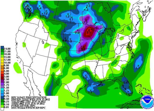
5-Day Rainfall Outlook. The heaviest rains looking out through Monday are forecast to fall over the Upper Midwest, Minnesota and western Wisconsin. The west stays dry, so does much of the east, only scattered T-storms from Florida into the Lower Mississippi Valley.
Q: The National Oceanic and Atmospheric Administration, called NOAA, predicts a near-normal 2012 Atlantic hurricane season with a 70 percent chance of nine to 15 named storms with top winds of 39 mph or higher. Four to eight storms will strengthen to hurricanes. Of those, one to three will become major hurricanes with top winds of 111 mph or higher, ranking category 3, 4 or 5. Do you agree?"

Backup records electronically. Dobzinski recommends keeping a set of backup records, including birth certificates, passport, tax returns and insurance policies, in a safe place away from the original set. "Even if the original record is only available on paper, it can be scanned into an electronic format," Dobzinski said. "With documents in electronic form, taxpayers can download them to a portable backup storage device such as an external hard drive, CD or DVD."
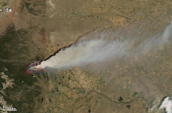
High Park Blaze From Space. Here's the latest from NASA's Earth Observatory: "The High Park Fire, about 15 miles (24 kilometers) west of Fort Collins, Colorado, was discovered just before 6:00 a.m. on June 9, 2012. Started by a lightning strike, the fire quickly grew, fueled by high winds and dry vegetation. By the morning of June 12, the fire had burned more than 43,000 acres (17,000 hectares), making it the third-largest fire in Colorado history. The Moderate Resolution Imaging Spectroradiometer (MODIS) on NASA’s Aqua satellite captured these images on June 9 (top) and June 10, 2012 (bottom). Red outlines show the approximate boundaries of actively burning fires. Thick smoke was carried eastward on both days."
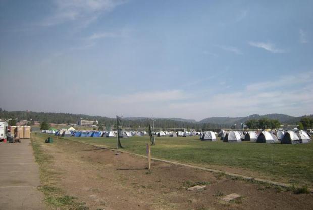
Temporary Housing. Hundreds of firefighters are fighting the blazes in New Mexico; here is a photo of the temporary housing, via Facebook: "Firefighter Housing at White Mountain Complex in Ruidoso, looking NW — with Brenda Dunn at White Mountain Recreational Complex.:
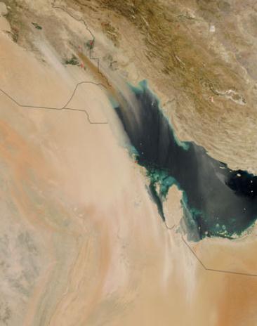
Massive Dust Storm. NASA MODIS has the details: "On June 2, 2012, a dust storm struck southeastern Iraq. Winds blew fine sediments toward the southeast, over the Persian Gulf, and into northeastern Saudi Arabia. Winds also kicked up streamers of dust in Qatar. The Moderate Resolution Imaging Spectroradiometer (MODIS) on NASA’s Aqua satellite captured this natural-color image the same day."

Photo credit above: "Wendy Bryan, a West L.A. graphic designer, says using reusable bags has paid off at her local Trader Joe's. Women in industrialized countries are more likely to buy ecologically friendly and organic foods, more likely to recycle and more interested in efficient energy use, according to research by the Organization for Economic Cooperation and Development." (Los Angeles Times / May 6, 2007)
America's Love Affair With The Motor Car Is Running On Empty. Another interesting article from The Guardian; here's an excerpt: "America's love of driving is iconic. The open road is a central manifestation of America the free. During the 20th century, the total movement of cars and trucks on our national roads and highways grew as fast as our economy, or faster. Movement – measured by total vehicle miles travelled (VMT) – was considered an unqualified blessing. In the 1960s each American drove about 5,000 miles a year in a car, van, or truck. By 2000 that number was 10,000 miles. Which means we are twice as well off – right? Wrong. In the early years of the 21st century, something very interesting happened. Individual vehicle travel in America lost its glamour – and its connection to economic growth. In 2003 when VMT was 2.9 trillion miles, US gross domestic product was just under $11tr. In 2011 GDP passed $15tr while total vehicle travel was still about 2.9 trillion miles."


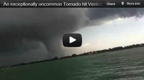
No Caption Necessary. Thanks to funtoosh.com for passing this one along. What I'd give for a sugar donut right now.
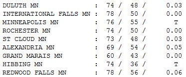
Unsettled Wednesday. A band of light showers drifted across Minnesota yesterday as warmer, stickier air pushed north. Clouds kept temperatures cooler; afternoon highs ranging from 60 at Grand Marais to 73 St. Cloud, 76 in the Twin Cities, and 78 at International Falls and Redwood Falls.
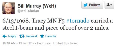
On This Date In History (courtesy of the Twin Cities National Weather Service):
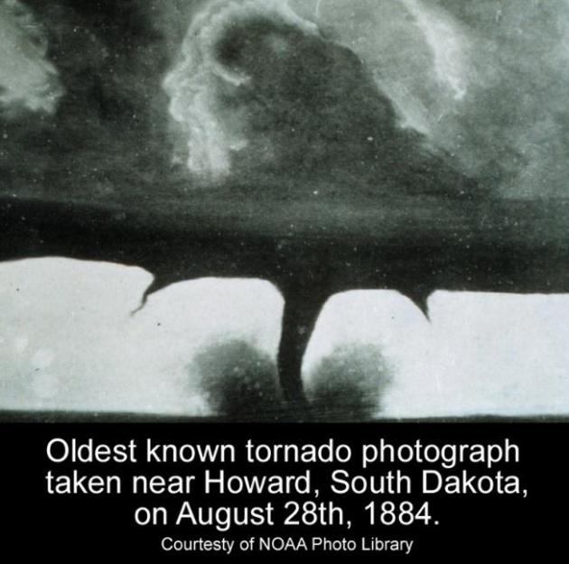
1981: Tornado hits Roseville, destroying homes and damages Har Mar Mall.
1956: 8 inches of rain fell in the Ivanhoe area in 3 and a half hours. 100 thousand dollars in damage to crops.
1943: Torrential downpours cause flooding in the Twin Cities and east central Minnesota. 2.5 inches of rain fell in St. Paul in two hours. In addition, four streetcars were hit by lightning.

Paul's Conservation Minnesota Outlook for the Twin Cities and all of Minnesota:
TODAY: More humid. Showers/T-storms likely, some severe later. Dew point: 65. Winds: S 15+. High: 81
THURSDAY NIGHT: Sticky, a few more T-storms possible. Low: 67
FRIDAY: Sunnier, isolated T-storm. Dew point: 60. Winds: SW 5. High: 89
SATURDAY: Wetter day of the weekend. A few showers, possible thunder. Dew point: 66. Winds: S 10-20. Low: 66. High: 79
FATHER'S DAY: More sun, probably the nicer day of the weekend. Dew point: 60. Winds: W/NW 8-13. Low: 61. High: 82
MONDAY: Another round of storms, possibly severe? Low: 69. High: 85
TUESDAY: Partly sunny, slight drop in humidity. Low: 68. High: 84
WEDNESDAY: Muggy again, more T-storms - some heavy. Low: 65. High: 82
* Long range mode guidance shows a significant drop in temperature and humidity by Thursday and Friday of next week.

Grad-Party-Paranoia
"Paul, I'm expecting hundreds of people in my
yard for a big grad party from 1 to 4 pm Saturday. Will it rain, and
what time?" If I could answer that question (now) I'd be semi-retired,
hanging out with Bill Gates and Warren Buffet.
We can tell when the atmosphere is ripe for
T-storms, but timing these brief, tiny, fickle storms - 10 miles wide at
times - is an exercise in futility. Computer models can't reliably
predict rain down to a city block, 48 hours in advance. They never will.
My oldest son, Walt, suggested an honest response. "Dad, tell her there will be some sun... in between tornadoes."
Right.
Mother Nature has a twisted, sadistic sense of humor. Have a Plan B.
T-storms later today may turn severe as another
hot front pushes north - stay alert. An isolated storm may pop tomorrow,
but most of Friday looks dry, highs near 90. Saturday looks like the
wetter day of the weekend; a few hours of showers and possible thunder
(but the latest computer run doesn't look quiet as wet. It should cool
off a bit over the weekend, readings may hold in the 70s Saturday, but
the sun should be out most of Father's Day; the nicer day of the weekend
- highs topping 80 across much of Minnesota.
A stalled front keeps us warm, muggy &
thundery from Monday into Wednesday, but cool, clean Canadian relief
arrives by Thursday.
My closing words of grad party advice: RENT THE TENT!
* image above courtesy of someecards.com.

Mitt Romney Worked To Combat Climate Change As Governor. The L.A. Times has the details; here's an excerpt: "During his first 18 months as governor of Massachusetts, Mitt Romney spent considerable time hammering out a sweeping climate change plan to reduce the state's greenhouse gas emissions. As staff briefed him on possible measures and environmentalists pressed him to act, Romney frequently repeated a central thought, people at those meetings said: That climate change is occurring, that the United States has the resources to handle its vast impact but that low-lying poor countries like Bangladesh would suffer greatly. "It was like a mantra with him," said a person who attended those meetings who declined to be identified because of the sensitivity of the topic. "His Cabinet members would look at him like, 'What?' He was the radical in the room."
Photo above: AP Photo/Evan Vucci.

1. Arizona, 0.639
2. Michigan, 0.622
3. Minnesota, 0.620
4. Wisconsin, 0.616
5. Vermont, 0.607
6. New Mexico, 0.603
7. Utah, 0.588
8. Maine, 0.587
9. Texas, 0.575
10. Massachusetts, 0.568
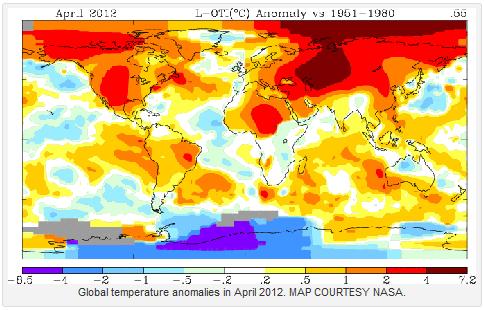
Global Warming: Yes, It Is The Greenhouse Gases. Here's an excerpt of a story from the Summit County Citizens Voice: "A detailed new modeling study of ocean temperatures reinforces the conclusion that observed warming is due to the buildup of heat-trapping greenhouse gases in the atmosphere. The scientists at Lawrence Livermore National Laboratory, together with international collaborators, said their results show that observed ocean warming over the last 50 years is consistent with climate models only if the models include the impacts of observed increases in greenhouse gas during the 20th century. “By using a “multi-model ensemble,” we were better able to characterize decadal-scale natural climate variability, which is a critical aspect of the detection and attribution of a human-caused climate change signal,” said Livermore Lab researcher Peter Gleckler, lead author of the new study that appears in the June 10 edition of the journal, Nature Climate Change."
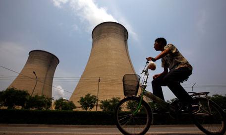
Coal's Resurgence Undermines Fight Against Global Warming. The Guardian has the story; here's an excerpt: "Coal has carved itself a 30% share of the global energy market - its highest level in over 40 years - undermining attempts by governments to reduce their carbon emissions, new figures show. China and India both increased their use of carbon-heavy coal by over 9% but Europe, where political consensus against global warming is strongest, also saw a 4% increase, according to the BP Statistical Review of World Energy. Christof Ruhl, BP's chief economist presenting the figures in London on Wednesday said industrialisation of developing countries and cheap prices were driving coal demand which had "profound implications" for CO2 output."
Photo credit above: "Coal-burning power station in Beijing, China. Coal's shares of the energy market is at a 40-year high." Photograph: David Gray/REUTERS
Obama's Hope....And Climate Change. Here's an excerpt of an Op Ed from investors.com: "Election '12: President Obama plans to make climate change his top priority for his second term. No, that's not from The Onion, a humor publication, but the left-leaning New Yorker. What planet does this president live on? 'Obama has an ambitious second-term agenda," wrote Ryan Lizza in this week's New Yorker. "The President has said that the most important policy he could address in his second term is climate change," supposedly to "improve the world." So forget about the abysmal jobless numbers above 8% for over three years, or the $15 trillion deficit that threatens to turn the U.S. into Greece. No, amid those very real calamities, climate change is more important."
No comments:
Post a Comment