Heat Warning
By Paul Douglas
In 1995 I was working in Chicago (long story - not one of my better decisions), when a sudden spike in temperature and humidity approached. I'll take this to my grave. The Executive Producer at the TV station wanted to do schtick. "Which city will be hotter, Chicago or Phoenix? C'mom Paul, let's have some FUN with this segment!" I told her that people were going to die, that this was no time for happy-talk-news. Within 3 days a total of 750 people had perished, mostly elderly and shut-ins.
Researchers found it wasn't the afternoon heat - but the
relentless nighttime warmth. People just couldn't find any relief as
"lows" stayed above 83F for a few nights.
NOAA has issued an Excessive Heat Warning thru Thursday
night. Temperatures "cool" into the mid-90s today, but bounce back up
to near 100 on the 4th and Thursday. Dew points above 70 will make it feel like
110F. Check on friends, neighbors and family. The elderly and sick are most at
risk of heat-related ailments.
The worst of the blast-furnace heat pushes south late week,
more numerous T-storms over the weekend, highs near 90. Almost tolerable.
Stay hydrated, avoid PM sun, and slow down. A 100-degree 4th
of July? Yep.
___________________________________________________________________________________________
Todd's Conservation MN Outlook for the Twin Cities and all of Minnesota:
TUESDAY: Heat wave continues. Unsettled, few lingering T-storms Dew point: 73. High: 95. Heat Index: Up to 105.
TUESDAY NIGHT: Partly cloudy and still quite sticky and warm. Low: 78
4th Of JULY: Summer sizzle. Hot, hazy & humid. Whew... Slight chance of thunder late. Dew point: 74. High: 96
THURSDAY: Is it over yet? Sizzling. Some afternoon thunder possibe. Dew point: 74. Low: 77. High: 96
FRIDAY: Sweaty sun, chance of T-storms across southern MN. Low: 76. High: 91
SATURDAY: Just a touch cooler. Still very warm with a lingering thunder chance. Low: 70. High: 89
SUNDAY: Another warm day and unsettled day, slightly less humid. Low: Low: 68. High: 87
MONDAY: More Sun and slightly cooler. Low: 67. High: 84
__________________________________________________________________________________________
Excessive Heat Continues
These are all the latest Excessive Heat
Warnings and Advisories that have been posted by the National Weather
Service. Heat Index values could top 100° again Tuesday afternoon for all
the counties in orange or pink.

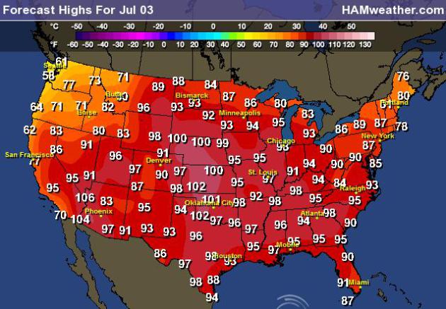
Forecast Highs Tuesday
These are the forecast
high temperatures for Tuesday across the nation. There will likely be more
record high temperatures as temperatures soar into the 90s
and 100s… stay cool!
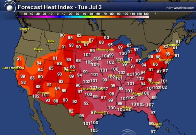
Heat Index Forecast
The
image below shows the forecast heat index for Tuesday, July 3rd, 2012.
These are some dangerous numbers, so be careful out there!
Steamy Week Continues
Looks like there won’t
be much relief from the heat for your 4th of July festivities. The
image below shows the maximum heat index for Wednesday, July 4th… It’s
going to be a steamy 4th of July as heat index values get up into the
100 to 110 range for much of eastern half of the nation!

Local Heat Index
Click on any city from
the link above and get the extended Heat Index forecast… Here’s
Minneapolis’ heat index forecast. The highest heat index values are
expected Wednesday-Friday (100° to 105°) with a 30% chance of seeing a
110° heat index on Friday.

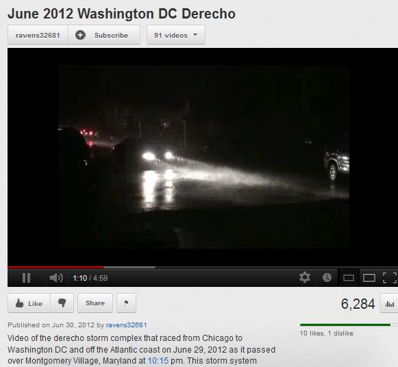
More on Friday's Derecho
These high temperatures could be even
more uncomfortable for folks who lost power over the weekend. Imagine
no air conditioning in this heat?
In Northern Illinois this morning,
100,000 Commonwealth Edison customers were still without power and a
spokesperson at ComEd says it could take several days to restore
service. Click Here to read more from the Chicago Tribune.
More than a half million customers are still without power in the Mid Atlantic. after Friday’s Derecho. Click Here to read more from CBS.
Extraordinary energy: Friday night’s derecho in Washington, D.C.

"One
of the key metrics for evaluating prospects for explosive thunderstorm
development is called Convective Available Potential Energy, or CAPE.
It’s an estimate of “fuel” available to developing thunderstorms.
The CAPE levels Friday night as the derecho approached Washington, D.C. were - in short - astronomical."
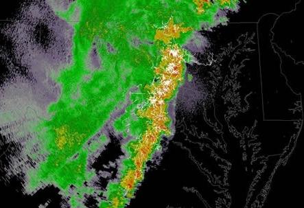
Crazy Lightning From Friday's Derecho
"The wind stole the show, but the second most striking feature of Friday night’s derecho was the vivid, almost continuous display of lightning.
The amount of atmospheric energy for this event was through the roof, priming the sky for the lightning spectacle.
It turns out the coverage and intensity of lightning was measured and mapped via a local network of 10 sensors known as the Washington, D.C. Lightning Mapping Array (DCLMA)."
Study Finds Coffee Could Cut Skin Cancer Risk
“Good news, java junkies: Researchers have found the more coffee
you drink, the more you may be protecting yourself against skin cancer.
Wildfires Continue
Are you seeing orange or red
sunrises/sunsets? There’s a lot of smoke in the air from wildfires out
west! The photo below is from the Arapaho Fire in Wyoming.

clouds of smoke turn the horizon orange and brown as a result of smoke on Saturday
The Arapaho Fire is currently 75,051.
Some structures have been destroyed but the area is still too dangerous
to allow a detailed assessment.
Waldo Canyon Fire Progress Report
Still no word on a cause for this
fire The Waldo Canyon Fire which is the most destructive in Colorado
history, with 346 homes lost. Cost to Date: $11,102,837 The blaze has burned 17,827 acres and is now 55 percent contained. From this morning’s update on Inciweb.com:
Firefighters continued to make
progress on the Waldo Canyon fire overnight. Higher humidity’s and
cooler temperatures helped crews to further secure the perimeter.
Smoke Seen From Space
“When volcanoes erupt, toxic plumes are released, or wildfires burn, NOAA’s HYSPLIT model
is used to answer some fundamental questions: where will it go and how
concentrated will it be? The HYSPLIT wild fire smoke model run on June
29th, 2012 at 6z shows the cloud of smoke being emitted from many of the
wildfires raging in the Western U.S. The actual locations of these
point-source pollutants can be seen as very high concentration smoke
areas. The ability of the GOES satellite to detect aerosols is an important input to these models, as are the wind measurements derived from GOES infrared imagery.”

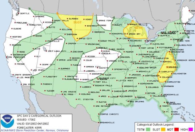
Severe Risk Tuesday
This is the severe
thunderstorm risk for today, which shows the greatest threat across the
northern part of Minnesota on the periphery of the extreme heat! Hail
and high winds will be the primary threat, but we can’t rule out an
isolated tornado.
Godzilla Wednesday?
Spicing it up in Richmond, VA… How about
this forecast from Aaron Justus from WTVR CBS 6. I’ll have to check the
latest model runs, I must have missed the global super storm being
deflected by Godzilla – LOL

Thanks for checking in, have a great rest of your week.
Don’t forget to check me out on Twitter @TNelsonWNTV

No comments:
Post a Comment