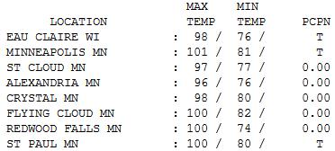
101 F. record high Wednesday in the Twin Cities (old record was 100, set in 1949).
81 F. morning "low" in the Twin Cities.
83 F. average high for July 4.
90 F. high on July 4, 2011.
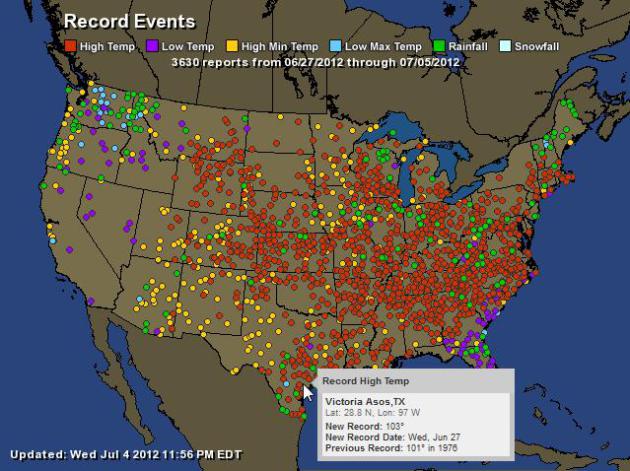
A Staggering Number of Record Highs. NOAA and
Ham Weather show 2,302 record highs in just the last week:
| Total Records: |
3630 |
| Rainfall: |
185 |
| High Temp: |
2302 |
| Low Temp: |
225 |
| Low Max Temp: |
90 |
| High Min Temp: |
828 |
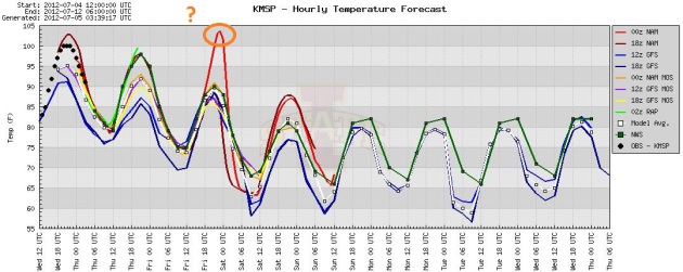
Two More Days of 90s - Then Some Relief. Expect mid
90s today, the 00z NAM model hinting at 100 again Friday (not so sure
about that; it's an outlier). But we're dealing with a fickle frontal
boundary. If that boundary lingers just north of MSP, then 95-100 F.
heat can't be ruled out again tomorrow. Either way all the models cool
us off into the 80s over the weekend.
European Solution. The ECMWF has been doing a
consistently better job than the (US) GFS model in recent month for Day
3-7. The latest run shows a cool-down over the weekend, highs next week
ranging from 95-100 F.
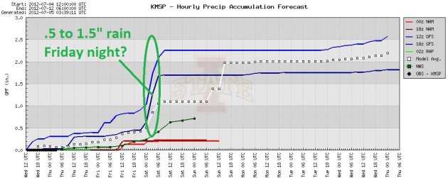
Continuity. The model ensemble continues to show the
best chance of rain (and heavy T-storms) late Friday into Saturday
morning as we make a transition from steamy 90s to more reasonable 80s,
as dew points drop into the 60s.
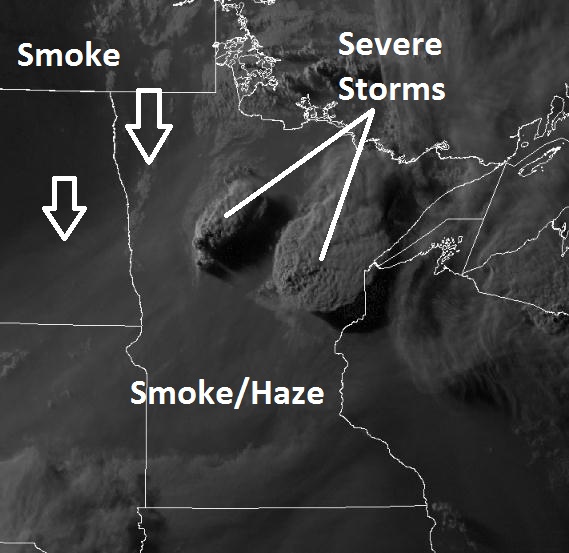
Hot And Smoky. The 8:30 pm Wednesday
visible satellite showed plumes of smoke from western wildfires pushing
into Minnesota (and severe storms popping up north).
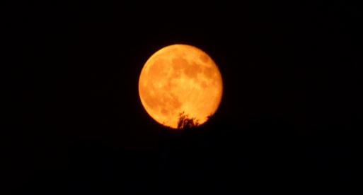
Blood-Red Moon. Susie Martin captured this photo Wednesday evening - smoke from western wildfires giving the moon an eerie orange cast.
Heat Safety Tips. Please take the heat seriously -
there will be problems with heat exhaustion and heat stroke later today.
Here's some timely advice from
NOAA:
Child Safety Tips:
- Make sure your child's safety seat and safety belt buckles aren't too hot before securing your child in a safety restraint system, especially when your car has been parked in the heat.
- Never leave your child unattended in a vehicle, even with the windows down.
- Teach children not to play in, on, or around cars.
- Always lock car doors and trunks--even at home--and keep keys out of children's reach.
- Always make sure all children have left the car when you reach your destination. Don't leave sleeping infants in the car ever!
Adult Heat Wave Safety Tips:
- Slow down. Reduce, eliminate or reschedule
strenuous activities until the coolest time of the day. Children,
seniors and anyone with health problems should stay in the coolest
available place, not necessarily indoors.
- Dress for summer. Wear lightweight, light-colored clothing to reflect heat and sunlight.
- Put less fuel on your inner fires. Foods, like meat and other proteins that increase metabolic heat production also increase water loss.
- Drink plenty of water, non-alcoholic and decaffeinated fluids. Your
body needs water to keep cool. Drink plenty of fluids even if you
don't feel thirsty. Persons who have epilepsy or heart, kidney or
liver disease, are on fluid restrictive diets or have a problem with
fluid retention should consult a physician before increasing their
consumption of fluids. Do not drink alcoholic beverages and limit caffeinated beverages.
- During excessive heat periods, spend more time in air-conditioned places.
Air conditioning in homes and other buildings markedly reduces danger
from the heat. If you cannot afford an air conditioner, go to a
library, store or other location with air conditioning for part of the
day.
- Don't get too much sun. Sunburn reduces your body's ability to dissipate heat.
- Do not take salt tablets unless specified by a physician.
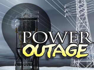
Potential For More Heat-Related Power Outages? The
combination of extreme heat (and humidity) and the specter of more
strong/severe T-storms into the weekend means a higher than usual
potential for power outages. Here's an excerpt from an article at The
Star Tribune: "
Xcel spokeswoman Mary Sandok said the high
temperatures can also cause outages. High energy use and heat can add
stress to the system, so there might be more outages as the hot weather
continues this week. Sandok said crews are working on outages around
the clock and encouraged people to reduce usage, particularly at peak
hours between the afternoon and early evening. She recommended users
try to run large appliances after 10 p.m. and to keep drapes and doors
closed to keep cool air in. Several thousand customers were without
power yesterday because of the heat, but their power was restored
before the storms." (image:
wtaq.com)
"
According to the National Oceanic and Atmospheric Administration
(NOAA), the period of January to May was the warmest on record for
Iowa, Illinois, Wisconsin, Michigan, Indiana, Ohio and Nebraska.
Minnesota and Pennsylvania ranked “much above normal.” - from The Des Moines Register; details below.
"
According to federal climate data, dozens of heat records have fallen or been tied
in the past week, and even more in the past month. In the past 30
days, the number of broken daily records climbed beyond 2,360, hitting
nearly 35,000 over the past year." - from an L.A. Times story; details below.
"The problem for those who dismiss climate change as a figment of
scientists' imagination, or even as a crypto-socialist one-worldish
plot to take away our God-given SUVs, is that the data are beginning to
add up." - from an Op-Ed at investors.com below.
18% of Americans questioned in a recent Washington
Post - Stanford poll said climate change was their #1 environmental
concern, down from 33% in 2007. Details from The Washington Post below.
10:1. Since January 1 the USA has experienced roughly
10 times more record highs than record lows, nationwide. Source:
NOAA NCDC.
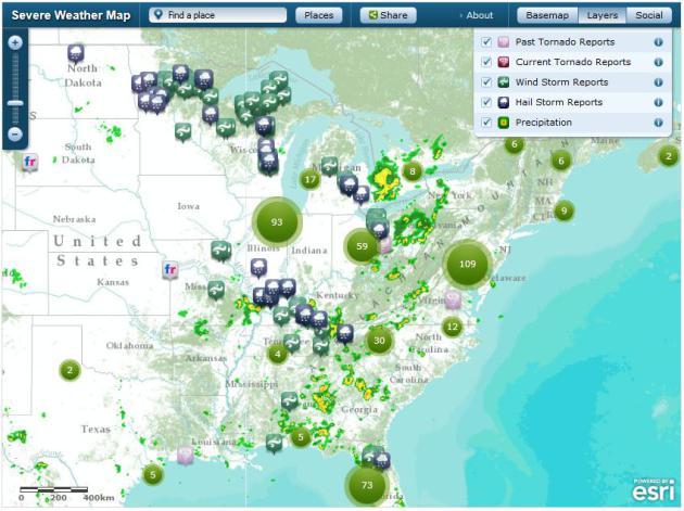
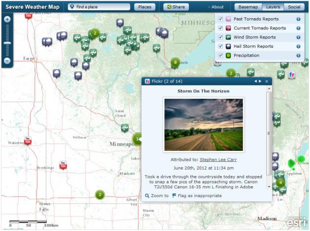
Severe Weather Visualization. The folks at
ESRI have done a very good job with this interactive map, showing real-time severe storm reports: "
View
continuously updated US tornado reports, wind storm reports, weather
warnings, and precipitation. See the real-time effects of the storm via
social media posts. To change the search terms, go to the Social menu,
click the settings icon, and update the keyword. For media inquiries,
contact us at newsmaps@esri.com."
As A Heat Wave Rolls Across U.S. - Scientists Predict More To Come. Here's an excerpt from a recent article at
The Los Angeles Times: "
Climate
scientists have this to say about the record-breaking heat wave
rippling across the country: Get used to it. This week’s spike toward
triple-digit temperatures is unusual, they say. But as Earth gets
warmer and greenhouse gases build, highs will keep getting higher.
“There have always been heat spells,” said Glen MacDonald, the director
of the UCLA Institute of Environment and Sustainability, in an
interview with the Los Angeles Times. “That’s just the climate system.
But … if you’re generally warming things, you have a greater chance to
reach new highs. Your hot spells become even hotter than they had in
the past.”
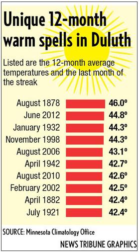
Past Year Among Warmest In Duluth Of All Time. The story from
The Duluth News Tribune; here's an excerpt: "
Duluthians
are about to complete a remarkable journey marking the warmest 12
months in 134 years, and maybe in recorded history. And there’s more on
the way. June in Duluth will end about 4 degrees warmer than the 30-year
normal if today’s weather turns out as forecasted. “It appears that
the past 12 months in Duluth, ending June 2012, will be among the
warmest 12-month periods of the climate record,” said Greg Spoden,
Minnesota’s state climatologist. “The only 12-month periods that top
our recent stretch are associated with the extraordinarily warm winter
of 1877-1878.”
In One Kansas Town, Even Hotter Than Usual. 115 F. air temperature at Hill City, Kansas last week? Hotter than Death Valley, California?
The New York Times has more details; here's an excerpt: "
For
five days last week, a brutal heat wave here crested at 115 degrees.
Crops wilted. Streets emptied. Farmers fainted in the fields.
Air-conditioners gave up. Children even temporarily abandoned the
municipal swimming pool. Hill City was, for a spell, in the ranks of the
hottest spots in the country. “Hell, it’s the hottest place on earth,”
Allen Trexler, an 81-year-old farmer who introduced himself as Old Man
Trexler. He spoke while standing in the shade of a tree on Saturday
morning, the temperature already sneaking toward 100."
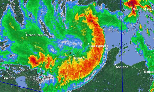
2012: Year Of The Derecho. Another massive bow echo
swelled up over northern Minnesota Monday evening, producing
straight-line winds in excess of 80 mph. at times - with numerous
reports of downed trees and powerlines.
* more on the straight-line wind damage from Monday night's severe thunderstorms up north from
The Star Tribune.
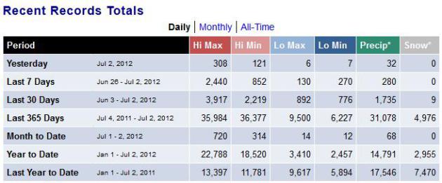
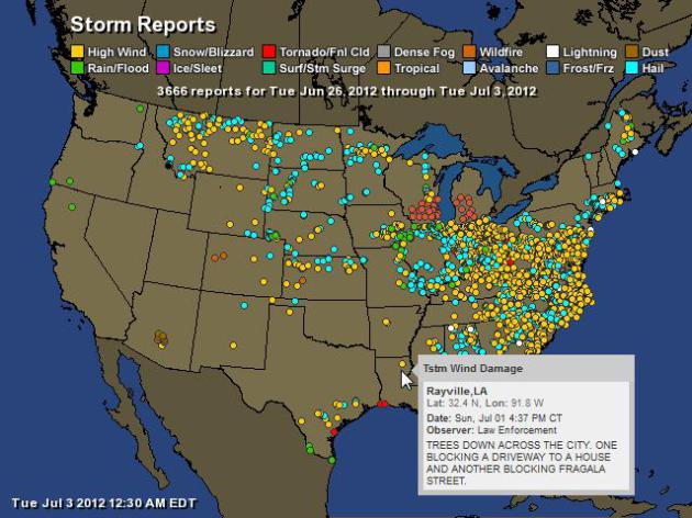
A Week's Worth Of Storm Reports. NOAA reports 3,666
storm and excessive heat reports in just the last 7 days. There were
2,374 severe (straight-line) wind reports in one week - I've never seen
anything like this, certainly not in mid-summer. For an interactive map
from Ham Weather
click here. Here's a breakout:
| Total Storm Reports: |
3666 |
| 0: |
1 |
| Wind: |
2374 |
| Rain: |
174 |
| Snow/Blizzard: |
1 |
| Tornado: |
15 |
| Hail: |
1003 |
| Fire: |
3 |
| Avalanche: |
1 |
| Lightning: |
21 |
| Dust: |
7 |
| 14: |
5 |
| 16: |
1 |
| Excessive Heat: |
60 |
Severe Storms + Social Media. One more look at the new online tool from
ESRI,
focusing on Minnesota's storms (and extreme heat). It's a mash-up of
NOAA storm reports, and weather-related tweets, photos and YouTube
clips. Pretty powerful.
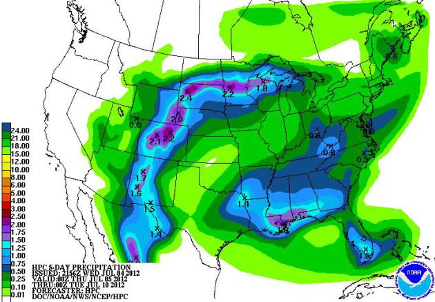
5-Day Rainfall. The tropics are quiet for the time
being, the best chance of heavy T-storms from New Mexico into the
High Plains, another rainy bullseye over the Gulf Coast. Map above: NOAA
HPC.
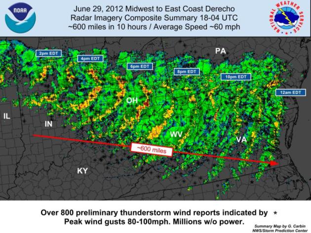
D.C. Derecho: Storm That Hit Capital Was Fast, Destructive - And Rare. Here's an excerpt of an article reprinted by The Washington Post at
The Seattle Times - from meteorologist Jason Samenow: "
It's
a hurricane. It's a tornado. No, it's a derecho. Only a meteorologist
was likely to have made the right guess about the violent storm system
that hit the Washington, D.C., area Friday night. Derechos occur only
about once every four years in the District of Columbia area, according
to the National Weather Service. They are more likely in the Midwest
and Great Lakes, between May and July. A derecho is a fast-moving,
long-lived, large, violent thunderstorm complex. By definition, it creates wind damage along a swath of more than 240 miles and produces wind gusts of at least 58 mph." (Image above: SPC).
* Friday's super-Derecho tracked nearly 700 miles, from Illinois to
coastal Delaware, moving at speeds as high as 60-70 mph, producing
straight-line winds over 90 mph. at times; roughly equivalent to a
Category 1 hurricane lasting less than 30 minutes.
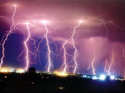
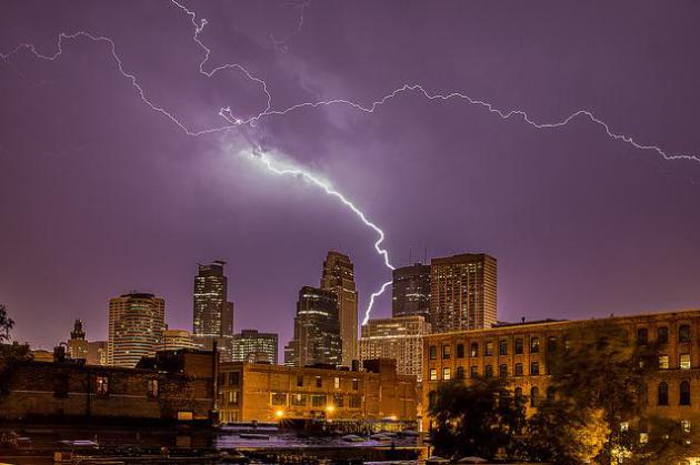
Photo Of The Day. Thanks to Bob Israel at RJI
Photography for this terrific show of cloud to ground lightning, taken
on June 19 in Minneapolis, via
flickr: "
This photo was taken on June 19, 2012 in North Loop, Minneapolis, MN, US, using a Canon EOS 5D Mark III."
"Ask Paul". Weather-related Q&A:
Hey, Paul.
"Here's a link I thought might interest you, if
you haven't already seen it. I received it from my son-in-law from
Arlington, Virginia.
I'm curious: we get this kind of thing all the
time, so why don't we call them derechos? Spanish for straight ahead, of
course, but I've never heard the word used in conjunction with a storm
before. We generally say straight-line winds, do we not? This
storm was so much bigger than it appeared at first report, and family
members in the area all said it just blew up out of nowhere. And yet, it
had ripped through three or four other states - which apparently do not
have the tracking and warning systems that we have. Your thoughts? BTW, please keep up the statements/warnings about global warming - we are still (collectively) not getting the message. Thanks for your decades of service to Minnesota!"
Best,
Maria Klein
Minnetonka, MN
Thanks Maria - appreciate the kind words and your interest in
derechos. If you Google "derecho" you'll find a wealth of information,
but these (boomerang-shaped) swirls of fast-moving severe thunderstorms
are still somewhat mysterious. They are most likely to form on highly
unstable days, with "CAPE" values higher than 3,000 or 4,000. Last
Friday CAPE values near Washington D.C. exceeded 5,000, off-the-scale
extreme. The more heat (and moisture) in the atmosphere, the greater the
potential for derecho formation.
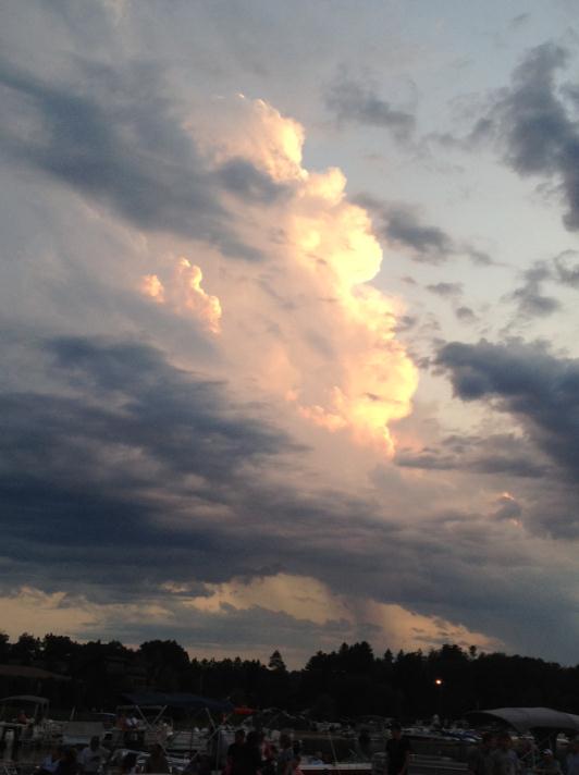
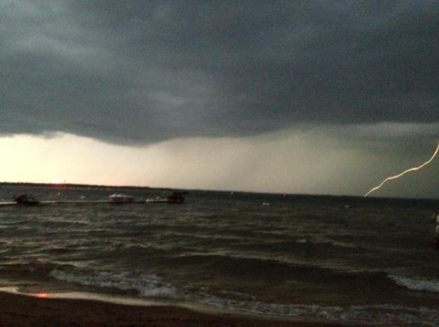
Towering Trouble. Note to self: taking the pontoon
over to Breezy Point Resort to see "Elvis" can be fraught with peril
this time of year, and a lousy pontoon doesn't offer much protection
from the elements. Massive cumulus congestus bubbled up overhead
Saturday evening, illuminated by the setting sun.
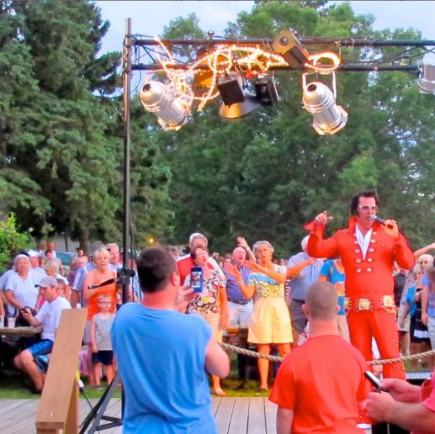
The...Real Deal? I'm starting to think so, yes.
Elvis can be seen up at Breezy Point Resort on Pelican Lake - I think
he's playing a few Saturdays through July - check the resort's web site
for details. Is it really...him? Not sure, but I have my suspicions. At
this point nothing would surprise me. BTW - he's good. Elvis hasn't lost
any of his charms or crooning abilities...
An Unstable Atmosphere. Either that or Mother Nature
was flipping me off. I snapped this photo Saturday evening up at Breezy
Point, on Pelican Lake. Monday evening a severe storm swept over
Pelican Lake, nearly continuous lightning - the southern extent of the
derecho that swept across northern Minnesota.
Fans Howl After Weather Site Buys Out Rival. What do
you think of The Weather Underground buy-out by TWC? They must have had
their reasons, I guess. With any luck The Weather Channel won't mess
with the secret sauce that made W.U. a must-visit destination. Here's
more from
The New York Times: "
The announcement on Monday that the Weather Channel Companies, owners of television’s Weather Channel and weather.com, would buy one of its rivals, Weather Underground,
set off howls of displeasure on social media platforms and around
water coolers across the nation. The purchase price was not disclosed.
In the eyes of Weather Underground’s ardent fans, the Weather Channel
appears to represent the wrong kind of weather information:
personality-driven sunniness and hype, they say, rather than the pure
science of data. As Mike Tucker, a computer professional in New
Hampshire, put it on Facebook, reacting to news of the deal:
“Nooooooooooooooooo! Waaaaaaaaaaaaaaaaaaah!”
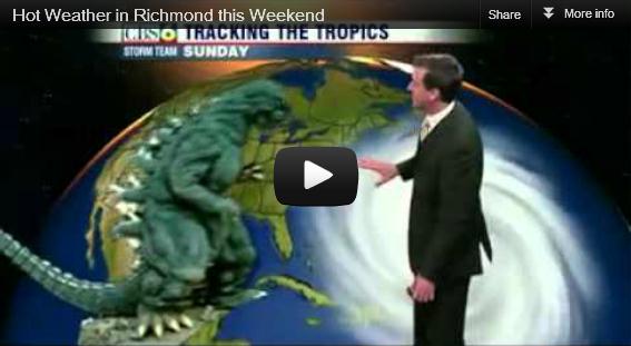
Hilarious Spoof Forecast In Midst Of East Coast Heat Wave.
I have to hand it to Richmond TV meteorologist Aaron Justus, who did a
very good job taking viewer's minds off the oppressive heat.
Huffington Post has details, and the video (which is worth a look): "
Aaron Justus, weatherman for local CBS affiliate WTVR, sure knows how to handle a high-pressure situation. Faced with volcanic eruptions, massive tropical storms and battles with Godzilla, Justus manages to maintain his professional tone
-- giving the good people of Richmond, Va., the information they'll
need to get them through the next few days of terror. Comedy aside, the
last few weeks have seen plenty of record-breaking weather across the
country."
Oops. My bad. Thanks to someecards.com for sending this along.
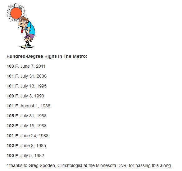
Fun With Triple Digits. The Twin Cities suburbs and
Redwood Falls all enjoyed (?) 100-degree heat yesterday; the morning low
in Eden Prairie a toasty 82. That's within 1 degree of our average high
for July 4.
* photo credit above
here.
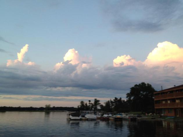
 Fireworks
 courtesy of WeatherNation TV meteorologist Susie Martin.
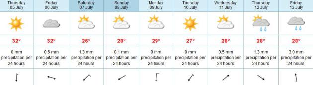
Paul's Conservation Minnesota Outlook for the Twin Cities and all of Minnesota:
TODAY: Stuffy and hot with intervals of sun, stray T-storm. Dew point: 74. N 5-10. High: 96
THURSDAY NIGHT: Muggy with a few T-storms possible. Low: 72
FRIDAY: Sticky, more numerous PM T-storms. Dew point: 70. High: 92
SATURDAY: Unsettled, few T-storms likely. Dew point: 67. Low: 70. High: 84
SUNDAY: Storms linger south, drier and sunnier north - not as oppressive. Dew point: 64. Low: 66. High: 85
MONDAY: Plenty of sun, more comfortable. Low: 68. High: 87
TUESDAY: Partly sunny & quiet. Dew point: 63. Low: 67. High: 88
WEDNESDAY: Mix of clouds & sun, plenty warm. Low: 68. High: 87
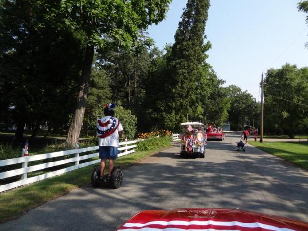
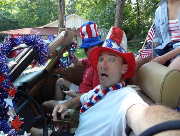
Glass Half Full
Norman Rockwell would be proud. My neighborhood
has a 4th of July celebration every year, with a 3 block "parade"... a
few token convertibles, a guy on a Segway scooter, little girls pulling
red wagons - all topped off with root beer floats.
Independence
Day is a chance to reflect and give thanks for the brilliance of
America's Founding Fathers. It's an opportunity to remind my 2 boys how blessed we all are.
"Do
you realize how lucky we are - to have been born here - at this moment
in time?" God knows we have big challenges, but would you really want to
live anywhere else?
Maybe someplace cooler, like Phoenix or Death Valley.
An
incendiary, character-building, 100-degree Wednesday gives way to real
relief: 80s return by the weekend - with a few heavy T-storms. Now
trying to time those storms is a hopeless cause; models hint at Friday afternoon into Saturday morning as the best window for puddles.
Winds shift to the north later today, highs in the mid to upper 90s. You
know it's a real summer when 96 F qualifies as a "cool front". Highs
next week range from 85-90 F; plenty warm, but not ridiculously hot.
Back to my root beer float.
Tempted to pour it over my head.
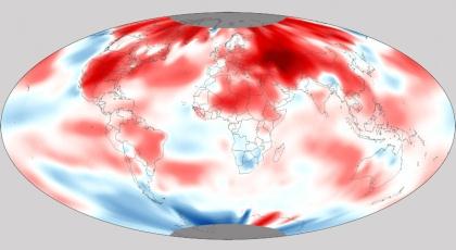
Climate Stories...
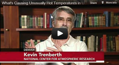
What's Causing Unusually Hot Temperatures U.S.? Can
we pin some of these extremes on a warmer atmosphere, or is all this
(atmospheric insanity) just normal, random weather. Most climate
scientists believe we passed normal a long time ago. Here's an excerpt
of an interview on Monday's
PBS Newshour with Judy Woodruff:
JUDY WOODRUFF: "
And when you say -- you used the term no parallel. You literally meant that?"
KEVIN TRENBERTH: "
I don't think there has been
anything quite like this before. Back in the 1930s, the Dust Bowl era
was very hot and dry. But, you know, I mean, every year is somewhat
exceptional. Last year, of course, there was heat waves and all kinds
of wildfires in -- centered in Texas, Arizona, New Mexico. And it was
extraordinarily hot in Oklahoma. The previous year, it was in Russia. In
2009, there were exceptional conditions in Southern Australia, in the
Melbourne area. And so these areas where the really hot and dry
conditions leading to wildfires has -- is moving around. We certainly
don't expect them to occur every year, but we do expect more of them.
The odds are changing for these to occur with climate change, with the
global warming from the human influences on climate."
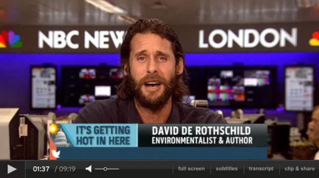
Summer Heat Wave An Early Indication Of Global Warming. Here's a video clip from
msnbc.com: "
Climate
change is driving temperatures up around the country, but are
conservatives ignoring all the talk of global warming? MSNBC's Alex
Wagner talks to author and environmentalist David De Rothschild about
what the heat means for the Earth, and what we should be doing to
prepare for future erratic weather."
This Summer "Is What Global Warming Looks Like." The story from AP and
seattlepi.com - here's an excerpt: "
Is
it just freakish weather or something more? Climate scientists suggest
that if you want a glimpse of some of the worst of global warming,
take a look at U.S. weather in recent weeks. Horrendous wildfires.
Oppressive heat waves. Devastating droughts. Flooding from giant
deluges. And a powerful freak wind storm called a derecho. These are
the kinds of extremes experts have predicted will come with climate
change, although it's far too early to say that is the cause. Nor will
they say global warming is the reason 3,215 daily high temperature
records were set in the month of June. Scientifically linking
individual weather events to climate change takes intensive study,
complicated mathematics, computer models and lots of time. Sometimes it
isn't caused by global warming. Weather is always variable; freak
things happen."
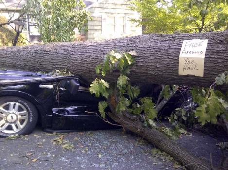
Photo credit above: "A
tree sitting atop a vehicle offers free firewood in Falls Church, Va.,
Monday, July, 2, 2012, as cleanup continued after Friday's storm,
Around 2 million utility customers are without electricity across a
swath of states along the East Coast and as far west as Illinois as the
area recovers from a round of summer storms that has also caused at
least 17 deaths." Photo: Matthew Barakat / AP
Feeling The Heat: It's Too Hot To Be A Global Warming Skeptic. Here's an excerpt of a post from
investors.com: "...
This
is the point in the column where I'm obliged to insert the disclaimer
that no one event — no heat wave, no hurricane, no outbreak of
tornadoes or freakish storms — can be definitively blamed on climate
change. Any one data point can be an anomaly; any cluster of data points
can be mere noise. The problem for those who dismiss climate change as
a figment of scientists' imagination, or even as a crypto-socialist
one-worldish plot to take away our God-given SUVs, is that the data are
beginning to add up. The National Oceanic and Atmospheric
Administration says the past winter was the fourth-warmest on record in
the United States. To top that, spring — which meteorologists define
as the months of March, April and May — was the warmest since
record-keeping began in 1895. If you don't believe me or the scientists,
ask a farmer whose planting seasons have gone awry."
"Climate Scores" Keeps Representatives Accountable On Climate Change Legislation. Details from
treehugger.com: "
A
new online scorecard helps you keep your representatives accountable
for their votes on climate change legislation and lets you reach out to
them via Facebook, Twitter, emails, and phone calls. How does your
Senator or Congressman score on important climate change legislation?
Now you can find out how they voted on key bills and amendments, and
reach out to them with either your kudos or your urging to work for
better and longer-lasting climate change legislation. Climate Scores
aims to make the actions of members of Congress on important climate
change issues more transparent, and hold them accountable to us, their
constituents."
Minnesota House Climate Change Legislation Grade. Here are the latest "grades" for Minnesota House legislators; more from Climate Scores
here.
Iowa View: More Extremes Seen As Climate Changes.
We're all witnessing the symptoms of a warming atmosphere: more intense
heat waves, more extreme thunderstorms (and super-derechos), more flash
flooding, while the west dries out, fanning more intense and
longer-lasting wildfires. Here's an excerpt of an Op-Ed at
The Des Moines Register: "
Many
people are asking the same question: As the climate changes, can we
expect more of this? The answer: Yes. There is a strong probability that
climate change is influencing extreme weather events — heat waves,
drought and floods. That’s what we know. We’re not alone. Insurance
industry leaders think so, too, and they have been meeting with U.S.
senators to call for action. The extreme weather events with huge costs
thus far in 2012 unfortunately reflect a growing recent trend. In
2008, 2010 and 2011, there were 100- or 500-year floods in Iowa,
Missouri and Wisconsin. In April 2011, the nation suffered through 875
tornadoes; the previous one-month record was 542."
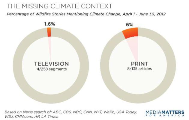
Study: Media Avoid Climate Context In Wildfire Coverage. From
Media Matters: "
While
numerous factors determine the frequency, severity and cost of
wildfires, scientific research indicates that human-induced climate
change increases fire risks in parts of the Western U.S. by promoting
warmer and drier conditions. Seven of nine fire experts contacted by
Media Matters agreed journalists should explain the relationship
between climate change and wildfires. But an analysis of recent
coverage suggests mainstream media outlets are not up to the task --
only 3 percent of news reports on wildfires in the West mentioned
climate change."
Clueless About Climate Change. Science literacy is
front and center - the sad fact: many Americans don't have the ability
to parse out the signal from the noise - and instead rely on talk radio
and TV "Talking Points". Instead of deferring to climate scientists, who
study this topic for a living, they automatically believe there are two
sides, that the climate deniers are somehow on an equal footing with
peer-reviewed Phd's. Here's more on the quandary from
climateaccess.org: "
There's
a dangerous meme drifting through the climate community: that when it
comes to "solving" climate change, literacy does not matter. True,
years of promoting filling the information deficit with more facts
hasn’t worked, but the current “literacy bashing,” repeated in climate
blogs and conversations, is unfortunate, oversimplified and, to be
blunt, nonsense. Literacy, particularly about 21st century challenges
such as climate and energy, does matter. The media is, as is often the
case, partly to blame. "Global warming skeptics as knowledgeable about science as climate change believers,"
read a recent headline from Fox News, reporting on a research paper by
Dan Kahan and colleagues published in Nature Climate Change entitled:
"The polarizing impact of science literacy and numeracy on perceived
climate change risks." Mother Jones' conclusion about the study: "Why Science Education Won't Solve Our Climate Problems."
Global Warming No Longer Americans' Top Environmental Concern, Poll Finds. More from
The Washington Post: "
Climate change
no longer ranks first on the list of what Americans see as the world’s
biggest environmental problem, according to a new Washington
Post-Stanford University poll. Just 18 percent of those polled name it
as their top environmental concern. That compares with 33 percent who
said so in 2007, amid publicity about a major U.N. climate report and Al Gore’s Oscar-winning documentary about global warming. Today, 29 percent identify water and air pollution as the world’s most pressing environmental issue."


No comments:
Post a Comment