96 F. high in the Twin Cities yesterday.
83 F. average high for July 5.
88 F. high on July 5, 2011.
97 F. predicted high today; dew points around 73 F. will make it feel like 105 by late afternoon.
Excessive Heat Warning posted from the Twin Cities south to the Iowa border.
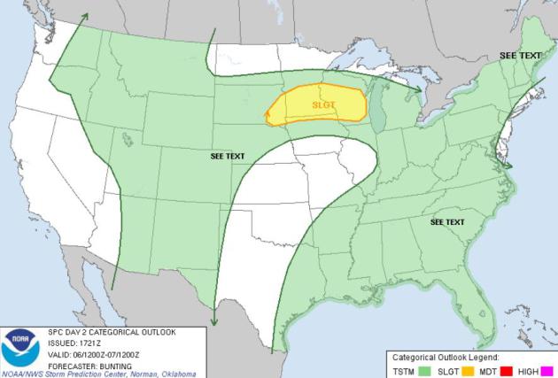
Severe Threat Today. A few storms today may spark large hail, straight-line winds over 60 mph, even an isolated tornado. Details from SPC below.
Irritable. A boundary separating 100-degree air over
southern Minnesota from 80s up north, coupled with a wave of low
pressure tracking across the Dakotas into northern Minnesota, may spark
enough wind shear and (extreme) instability for a few severe storms
today. Stay tuned for watches and possible warnings. Map: SPC.
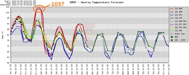
One More Heat Spike. The two latest NAM models (two
of the more reliable, short-range simulations) suggest a high from
103-105 F. later today. That may be overestimating the heat, but I'm
starting to believe that 100 F. is not out of the question this
afternoon, especially south of MSP. Low 80s will feel like a Christmas
present Saturday.
Hot Holding Pattern. The giant, sprawling heat-pump
high over the Plains wants to be a permanent feature on the weather map
this summer. After a few days of 80s early next week the ECMWF is
bringing more 90-degree heat into MSP the latter half of next week. No
more 100s in sight - thank God.
107 F. high at Evansville, Indiana Thursday, a new all-time record for July 5.
105 F. high at Paducah, Kentucky, another record for July 5.
"
Current temperatures are significantly hotter than the 1930s. We
saw the very significant impact on our country's farms back then; the
impacts now have the potential to be far more devastating. For instance,
the drought in Texas last year cost over $5 billion. This is real money
with real consequences. If we don't take action, we will be having
conditions worse than this on a regular basis." - Dr. John Abraham, climate scientist at the University of St. Thomas
"
The National Oceanic and Atmospheric Administration says the
past winter was the fourth-warmest on record in the United States. To
top that, spring — which meteorologists define as the months of March,
April and May — was the warmest since record-keeping began in 1895. If
you don’t believe me or the scientists, ask a farmer whose planting
seasons have gone awry."
"
NASA’s Goddard Institute for Space Studies, which monitors
global surface temperatures, reports that nine of the warmest 10 years
on record have occurred since 2000. The warmest year of all was 2010;
last year was only the ninth warmest, but global temperatures were
still almost a full degree warmer than they were during the middle of
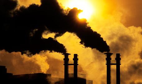
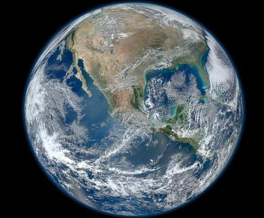
the 20th century." - from an Op Ed in The Miami Herald - details below. Image above: NASA.
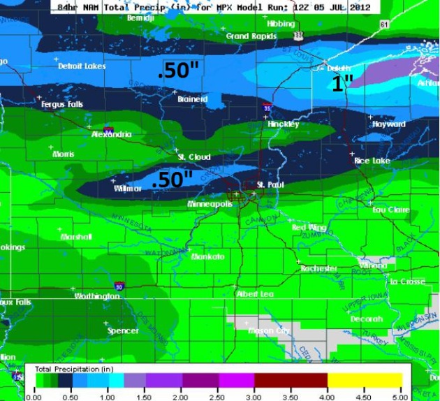
Heaviest T-storms: Central and Northern Minnesota?
The model ensembles are pretty consistent in guiding the heaviest
T-storms just north/west of the metro, some .50 to 1"+ amounts possible
from the Brainerd Lakes into Duluth.
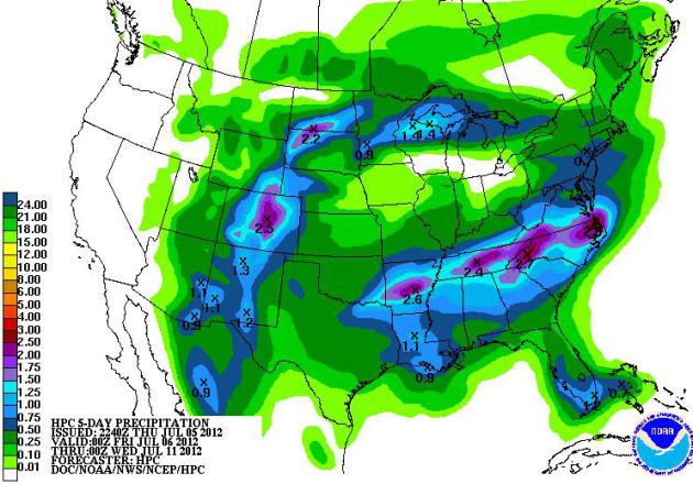
5-Day Rainfall Forecast. The latest QPF shows heavy
showers and T-storms (over 2") from Little Rock and Nashville to Atlanta
and Raleigh, more heavy storms near Denver and Colorado Springs
(helping to lower the fire risk). The west stays dry, the best chance of
some 1"+ amounts from Duluth into northern Wisconsin and the U.P. of
Michigan later today into Saturday morning.
Read more here: http://www.miamiherald.com/2012/07/05/2880449/feeling-the-heat-yet.html#storylink=cpy
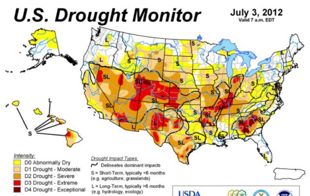
Searing Sun And Drought Shrivel Corn In Midwest. Here's a snippet from a
New York Times article about a growing drought gripping the Midwest: "....
Crop
insurance agents and agricultural economists are watching closely, a
few comparing the situation with the devastating drought of 1988, when
corn yields shriveled significantly, while some farmers have begun
alluding, unhappily, to the Dust Bowl of the 1930s. Far more is at stake
in the coming pivotal days: with the brief, delicate phase of
pollination imminent in many states, miles and miles of corn will rise
or fall on whether rain soon appears and temperatures moderate. “It all
quickly went from ideal to tragic,” said Don Duvall, a farmer in
Illinois who, in what was a virtually rainless June, has watched two of
his cornfields dry up and die as others remain in some uncertain
in-between."
* Image above courtesy of NOAA's
Drought Monitor.
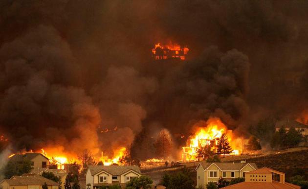
Colorado Wildfire Photos: The Waldo Canyon Fire in Colorado Springs. The
Denver Post
has a remarkable photo essay, including some of the most amazing (and
heart-breaking) photos I've ever seen, related to wildfires. A tornado
risk is one thing - but can you imagine a 5 mile wide wall of flames,
100 feet high, approaching your home at 40 mph? "
A three-day-old
wildfire erupted with catastrophic fury Tuesday, ripping across the
foothills neighborhoods of Colorado Springs, devouring an untold number
of homes and sending tens of thousands fleeing to safety in what was
shaping up as one of the biggest disasters in state history. “This is a
firestorm of epic proportions,” said Colorado Springs Fire Chief
Richard Brown. The Waldo Canyon fire in El Paso County
— which had been growing in the forested hills on the city’s west side
— blew into an inferno late in the afternoon, raging over a ridge
toward densely populated neighborhoods."
Photo credit above: "
The Waldo Canyon fire burns an entire
neighborhood in near the foothills of Colorado Springs, Colo. Tuesday,
June 26, 2012. Colorado has endured nearly a week of 100-plus-degree
days and low humidity, sapping moisture from timber and grass, creating
a devastating formula for volatile wildfires across the state and
punishing conditions for firefighters." (The Denver Post, Helen H. Richardson)
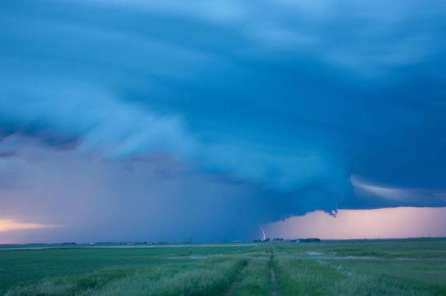
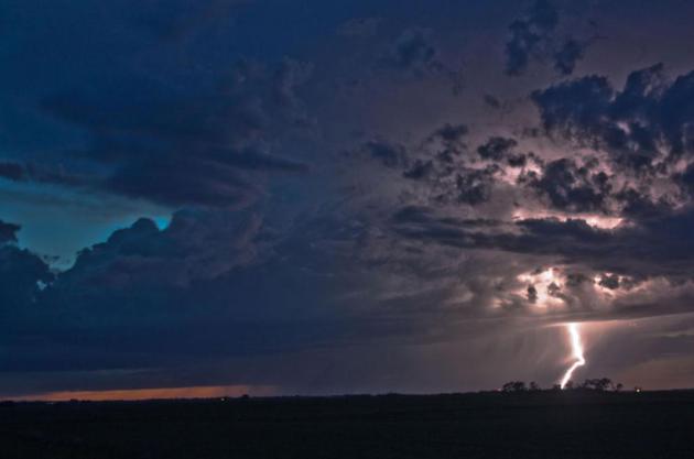
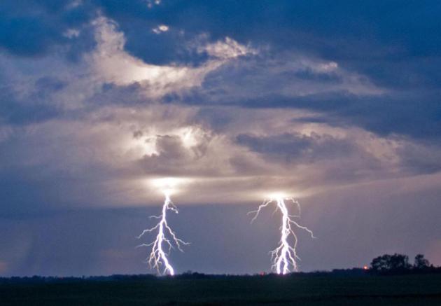
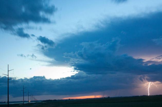
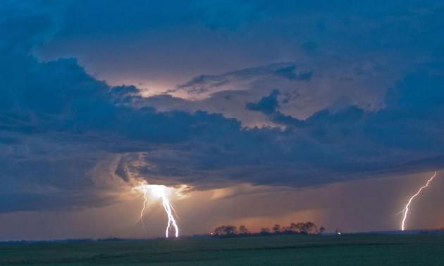
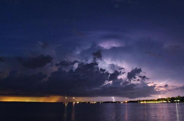
Spectacular Lightning Pics. Thanks to Warren Parsons, out in Penn, North Dakota, for sharing some
incredible lightning pics - taken at a safe distance, right? Appreciate you passing these along Warren!
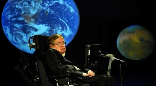
"iBrain" To Allow Stephen Hawking To Communicate Using Brainwaves Alone. Here's some amazing tech - the story from
gizmag.com;
here's an excerpt: "Tech startup Neurovigil announced last April that
Stephen Hawking was testing the potential of its iBrain device to allow
the astrophysicist to communicate through brainwaves alone. Next week
Professor Hawking and iBrain inventor, Dr Philip Low from Stanford
University, present their findings at the Francis Crick Memorial
Conference in Cambridge, England. In anticipation, Gizmag spoke to Dr
Low about the potential applications of the iBrain."
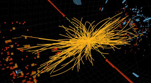
New "Boson" Discovered, Probably Higgs. This is
above my pay-grade, but I think it's a pretty big deal in the rapidly
changing world of physics. And what is "dark matter" anyway. The story
from
gizmag.com:
"Numbers are yet to be crunched and the data analysis goes on, but one
thing appears to be certain: scientists at CERN have discovered a new
boson, and it's probably the
Higgs particle,
the missing particle of the Standard Model which is thought to lend
all matter its mass. Both the ATLAS and CMS experiments at CERN observe
a new particle with mass between 125 and 126 GeV, comfortably within
the band of possible Higgs masses previously identified. "The results
are preliminary but the 5 sigma signal at around 125 GeV we're seeing is
dramatic. This is indeed a new particle."
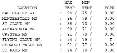
Hot Enough. No, we didn't crack 100 yesterday, but
with dew points in the low 70s it still felt pretty bad out there. Highs
ranged from 88 at St. Cloud (with a fresh north breeze) to 94 at Eau
Claire, 96 in the Twin Cities.
Paul's Conservation Minnesota Outlook for the Twin Cities and all of Minnesota:
TODAY: Heat Warning. Some sun, tropical again with T-storms, some possibly severe. Dew point: 73. Winds: S 15. High: 97
FRIDAY NIGHT: Muggy with more T-storms, some strong to severe. Low: 67
SATURDAY: Early storms, then some sun. Cooler, turning less humid. Dew point: 63. Winds: N 10-15. High: 83
SATURDAY NIGHT: Partly cloudy, much more tolerable out there. Low: 64
SUNDAY: Partly sunny, comfortable. Dew point: 58. High: 84
MONDAY: Sunny & pleasant. Dew point: 60. Low: 65. High: 85
TUESDAY: Warm sun, still dry. Low: 67. High: 87
WEDNESDAY: Hazy sun, heating up again. Low: 68. High: near 90
THURSDAY: Heat returns. Partly sunny and sticky. Dew point: 70. Low: 70. High: 92
Inflamed
"Ah, summer, what power you have to make us
suffer and like it" wrote Russel Baker.
Like? More like tolerate. I love
summer, but swamp-like heat is an acquired taste. If you could mash up
heat from Scottsdale with humidity from the bayous of Louisiana, you'd
have a pattern much like this.
At the rate we're going the Inflamed Summer of '12 may wind up hotter than the 1930s, at the height of the Dust Bowl.
Even accounting for the urban heat island -
nights have been trending warmer for 30 years now. It may be
counter-intuitive, but it's not the daytime heat, but sweltering nights,
that stress people, leading to life-threatening complications. People
can't find any relief, even at night. Not good.
One more day of Dubai (with lakes) as a wave of
low pressure pulls turbocharged heat north today; a few models hinting
at 100 F. The heaviest showers and T-storms soak central and northern
Minnesota, but a slow drying trend is likely over the weekend; Canada
leaking dew points in the upper 50s by Sunday. Improvement.
The shear scale and persistence of this heat wave is impressive, potentially historic.
After a few carefree days of 80s, more 90s return the latter half of next week.
Climate Stories...
Climate Change: "This Is Just The Beginning". Here's an excerpt of an article from Amy Goodman at
truthdig.com: "
Evidence
supporting the existence of climate change is pummeling the United
States this summer, from the mountain wildfires of Colorado to the
recent “derecho” storm that left at least 23 dead and 1.4 million
people without power from Illinois to Virginia. The phrase “extreme
weather” flashes across television screens from coast to coast, but its
connection to climate change is consistently ignored, if not outright
mocked. If our news media, including—or especially—the meteorologists,
continue to ignore the essential link between extreme weather and
climate change, then we as a nation, the greatest per capita polluters
on the planet, may not act in time to avert even greater catastrophe."
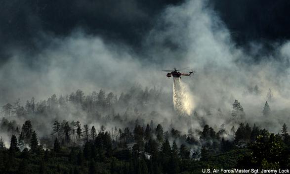
Photo credit above: U.S. Air Force; Master Sgt. Jeremy Lock.
Feeling The Heat Yet? Here's an excerpt of an Op-Ed in
The Miami Herald: "
Still don’t believe in climate change? Then you’re either deep in denial or delirious from the heat. "
As
I write this, the nation’s capital and its suburbs are in
post-apocalypse mode. About one-fourth of all households have no
electricity, the legacy of an unprecedented assault by violent
thunderstorms Friday night. Things are improving: At the height of the
power outage, nearly half the region was dark. The line of storms,
which killed at least 17 people as it raced from the Midwest to the
sea, culminated a punishing day when the official temperature here
reached 104 degrees, a record for June. Hurricane-force winds of up to
80 miles per hour wreaked havoc with the lush tree canopy that is
perhaps Washington’s most glorious amenity. One of my neighbors was
lucky when a huge branch, headed for his roof, got snagged by a power
line. Another neighbor lost a tree that fell into another tree that
smashed an adjacent house, demolishing the second floor."
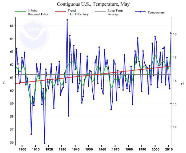
* graph above showing global temperature trends since 1900 courtesy of
NOAA NCDC.
Read more here: http://www.miamiherald.com/2012/07/05/2880449/feeling-the-heat-yet.html#storylink=cpy
 On The Media: Finally Seeing The Link Between Climate Change, Disasters?
 The story from NRDC and Bob Keefe at
Huffington Post: "
The
media just might be starting to see the obvious link between climate
change and extreme weather. Of course it’s hard to miss during a week or
so when we have deluges in Florida, wildfires in Colorado and deadly
freak storms in Washington D.C. and elsewhere along the Eastern
Seaboard. Scientists suggest taking a look at U.S. weather in recent
weeks.” Over in the new media world, Yahoo is carrying a story called “What’s Behind the Record Heat?” The answer: it could be “a hallmark of a warming planet.”
Climate Change Is Already Shrinking Crop Yields. Here's some bad news for farmers, an excerpt of a story from
Mother Jones: "
For
years now, people have wondered how climate change will affect
farming. How will humanity feed itself during a time of
rising temperatures and recurring drought? Here in the US, we're
starting to get a taste of things to come—and it's bitter. Brutal heat
is now roiling the main growing regions for corn, soy, and wheat, the
biggest US crops. According to Bloomberg News, 71
percent of the Midwest is experiencing "drier-than-normal
conditions," and temperatures are projected to be above 90 degrees in
large swaths of key corn/soy-growing states Missouri, Illinois, and
Indiana through July 7 if not longer."
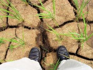
Photo credit above: IRRI Images, Flickr.
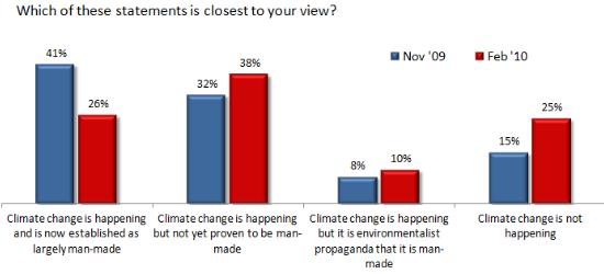
Climate Change Understanding Rebounds to 2009 Levels. Here's more from
Think Progress: "
Over
a short period at the start of 2010, belief that climate change is
real and manmade fell sharply. Since then, it recovered slightly but
had remained lower than it was at the end of 2009. But now three polls
have shown that the decline has been fully reversed."
Climate Change: Forest Warming Forces Warming. Here's a clip from a story at
Great Lakes Echo: "
A
rise of global temperatures will release more carbon dioxide from
forest soils, according to a new study that includes a look at a
Wisconsin forest. And that increased release of the greenhouse gas could
make the climate heat yet even faster. Scientists at the University of
the California Irvine heated by 10 to 20 degrees soil collected from
forests in Wisconsin and North Carolina. They discovered that the
warming released up to eight times more carbon dioxide. The study was published June 11 in the online edition of the Proceedings of the National Academy of Sciences journal."
Photo credit above: "
University of California-Irvine researcher Francesca Hopkins testing soil at an experimental forest in Wisconsin." Photo: University of California-Irvine.



Glad to read this amazing information which is so informative for me nice post. Compare life insurance prices
ReplyDelete