79 F. high yesterday in the Twin Cities.
83 F. average high for July 24.
83 F. high temperature on July 24, 2011.
1.74" rain fell yesterday at Twin Cities
International Airport, an all-time rainfall record for July 24. Previous
record: 1.44" on July 24, 1985
 ADHD Weather Update
 (for people in a big hurry):
"hot sun today (low to mid 90s) with the best chance of T-storms coming
this morning, north of MSP. A wind shift to the northwest brings today's
hideous (70-73 F) dew points down to near 60 by Thursday night, meaning
a welcome drop in humidity. A stray instability shower or T-shower is
possible late Thursday, but dry weather prevails Friday and Saturday
(the nicer, sunnier, more comfortable day of the weekend). We slowly
warm over the weekend; a few T-storms Sunday and Monday marking the
arrival of the next hot front. The ECMWF model is suggesting more mid
90s by the middle of next week."
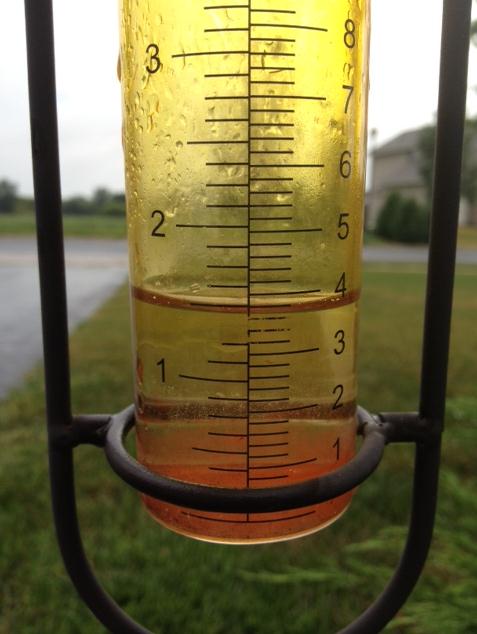
Multi-Million Dollar Rain. 1.5" in the rain gauge
out in Cologne - according to WeatherNation TV meteorologist Bryan
Karrick. Farmers in central and southern Minnesota are breathing a
little bit easier.
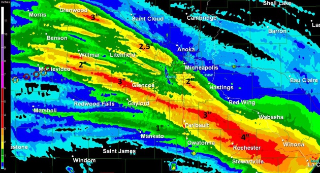
Multi-Million Dollar Rainfall. The storms that
lingered over central and southern Minnesota Monday night and Tuesday
morning squeezed out some 1-3" amounts from Glenwood and Glencoe into
the southern suburbs of the Twin Cities, as much as 2-4" near Rochester.
Farmers weren't exactly doing cartwheels, but it was enough rain to
make a real difference, coming at the end of the corn tassling phase.
7% of Americans work for the American government, about the same percentage as during the late 1970s. Details from
businessinsider.com.
70% of Americans now believe the climate is
changing, based on a recent University of Texas poll, up from a low of
52% during the winter of 2010. Details from philly.com below.
"
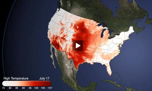
According to NOAA, more than 25,000 new record temperature highs have been set this year alone in the United States. A recent report from
the National Climatic Data Center noted that the past twelve months
were the warmest since record-keeping began in the U.S. in 1895. The
number and intensity of extreme weather events has also risen -- a shift
the Intergovernmental Panel on Climate Change concluded is linked to climate change. Four out of five Americans live in counties that have had natural disasters declared since 2006." - from a Huffington Post story; details below. Image above:
NOAA.
"
For several days this month, Greenland's surface ice cover
melted over a larger area than at any time in more than 30 years of
satellite observations. Nearly the entire ice cover of Greenland, from
its thin, low-lying coastal edges to its 2-mile-thick (3.2-kilometer)
center, experienced some degree of melting at its surface, according to
measurements from three independent satellites analyzed by NASA and
university scientists." - from NASA JPL, details below.
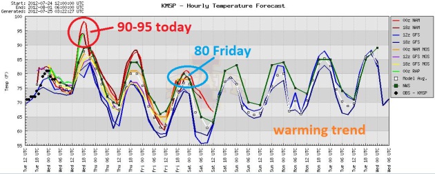
A Brief Respite From The Heat. After surging into
the low and mid 90s today (assuming a few hours of midday sun) a
northwest breeze "cools" us down to near 80 for a high by Friday. A
warming trend returns over the weekend, accelerating into the 90s again
next week (see the ECMWF model below).
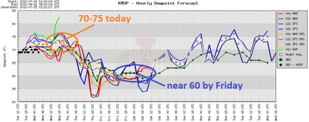
One More Day Of Swamp-like Humidity. Dew points soar
into the low and mid 70s today, before falling into the upper 50s to
near 60 by Friday. A case of the stickies returns by Sunday. Graph: Iowa
State Meteorology Department.
Endless Summer. Yes, that light at the end of the
tunnel is probably an oncoming train. I keep waiting for the Heat Wave
of 2012 to come to a close, but long-range (ECMWF) models suggest low
and mid 90s returning by the middle of next week. 35 days at or above 90
F. this year? It looks more likely than ever.
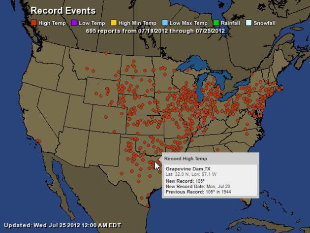
Record Highs. NOAA data shows 695 record highs in just the last week east of the Rockies. For an interactive map from Ham Weather
click here.
Drought-Stricken Farmers Buy Up Minnesota Hay. Here is an excerpt of a very interesting article from the
St. Cloud Times: "
As
a record drought parches the nation’s midsection, ranchers are turning
to Minnesota for hay to feed their cattle. Harlan Anderson, who grows
800 acres of hay near Cokato, said that he’s getting calls from just
about every corner of the country from farmers who view Minnesota as an
oasis. “I don’t think ever in my life I’ve seen it where the rest of
the country is as dry as it is and we’ve got a good crop,” Anderson
said. And the phone is ringing off the hook at Steffes Auctioneers in
Litchfield. Auctioneer Randy Kath has proof of the demand for
Minnesota’s hay: a legal pad scrawled with the 33 phone messages left
for him while he was in Canada over the weekend looking for hay to
broker in the U.S."
On Our Radar: Rising Corn Prices. Here's an excerpt from
The New York Times: "
World corn prices
have jumped 55 percent in six weeks to a new record as a result of the
Midwestern drought. [The Guardian] Japanese officials investigate the
possibility that workers at the Fukushima Daiichi nuclear plant were pressured to underreport
the amount of radiation they were exposed to so they could stay on the
job longer. [The Christian Science Monitor] Facing oil drilling, an
influx of freight haulers seeking a shortcut across the top of the
world and the arrival of passenger cruise ships as the ice melts, the
Coast Guard is scrambling to figure out how to police Arctic waters. [The New York Times]"
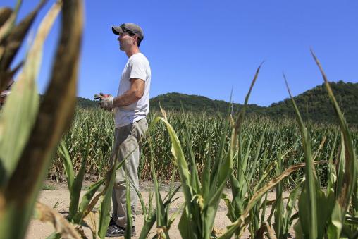
Photo credit above: "
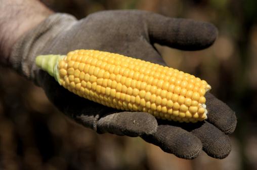
Keith Greshik, 43, a grain farmer
near Cochrane, Wis., took a look at some of the corn on one of his
fields that were ruined by the drought, Monday, July 23, 2012. The
drought that has hit the Midwest is the worst Wisconsin has seen in
nearly 25 years. On Thursday, Gov. Scott Walker said the entire state
was in a 'drought emergency' and sought federal disaster aid for 23
counties in the south central and southeastern part of Wisconsin." Courtesy: Elizabeth Flores, Star Tribune.
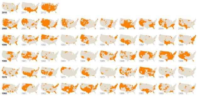
Drought's Footprint.
The New York Times has an amazing infographic that shows the "footprint" of drought across the USA, every year dating back to 1899. Details: "
More
than half of the country was under moderate to extreme drought in
June, the largest area of the contiguous United States affected by such
dryness in nearly 60 years. Nearly 1,300 counties across 29 states
have been declared federal disaster areas. Areas under moderate to
extreme drought in June of each year are shown in orange (above)."
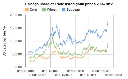
U.S. Drought Could Trigger Repeat Of Global Food Crisis, Experts Warn. More on what's happening in the Corn Belt from
The Guardian: "
America's drought
threatens a recurrence of the 2008 global food crisis, when soaring
prices set off riots and unrest to parts of Africa, the Middle East, and
Latin America, food experts warn. Corn prices reached an all-time
high on Friday, as the drought expanded across America, trading at
$8.24 a bushel on the Chicago exchange. Soybeans were also trading at
record levels. The US department of agriculture meanwhile predicted
there would be less corn coming onto global markets over the next year,
because of a sharp drop in US exports. America is the world's largest
producer of corn, dominating the market. Corn is also connected to many
food items – as feed for dairy cows or for hogs and beef cattle, as a
component in processed food – expanding the impact of those price rises."
Graphic credit above:
Food prices. Source: Rabobank
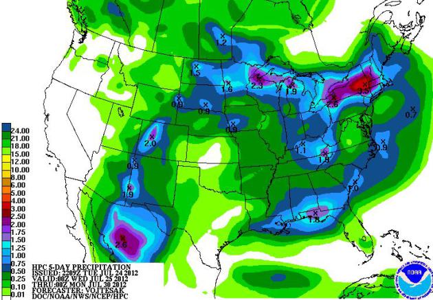
Drought Intensifies. Some counties in the Corn Belt (Ohio Valley) has received 1-2" of rain in recent days,
enough to put a small dent in the drought. But conditions are getting
worse over the Central Plains, the Wheat Belt, where little or no rain
is expected over the next 5 days. Map above: NOAA HPC.
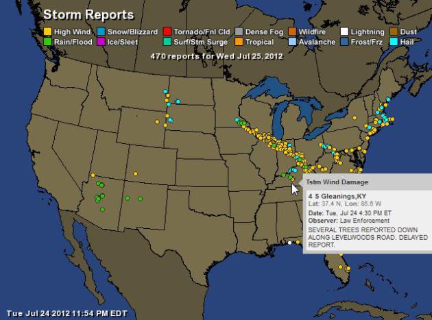
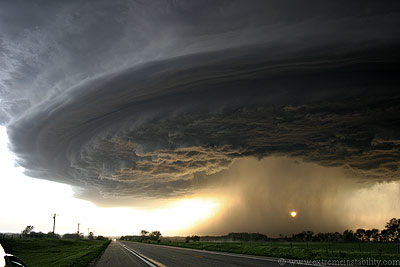
Another Derecho. The same storms that dumped up to
3" of rain on southern Minnesota Monday night went on to form into a
"derecho", a fast-moving, boomerang-shaped swirl of severe thunderstorms
that sparked 70 mph wind gusts from near Chicago into the Carolinas.
Although not as severe as the derecho that swept across the same region
in late June, it was violent enough to down countless trees and
powerlines from Indiana to West Virginia. Map above: NOAA and
Ham Weather.
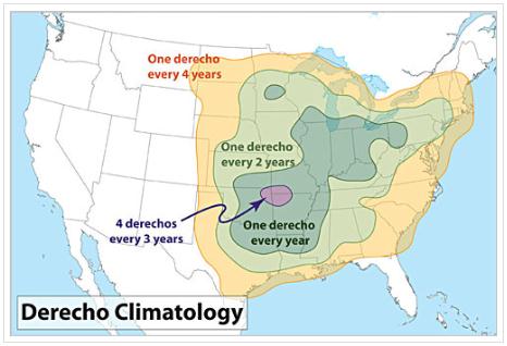
Derecho Climatology. NOAA data shows the highest
frequency of derechos over Texarkana, with a high probability extending
into the Midwest and Ohio River Valley.
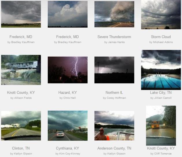
Another Wild Severe Weather Day.
Another derecho whipped up near Chicago - tracking eastward across the
Ohio Valley, surviving all the way into the Carolinas with 70 mph plus
wind gusts and large hail. The images above are from WeatherNation TV's social library - contributed by viewers around the USA.
Vincente: A Hurricane Forecasters Nightmare.
This really is the worst-case scenario for a hurricane forecaster: a
storm that flares up from Category 1 to Category 4 or 5, virtually
overnight. People along the coast are complacent ("hey, it's only a
Category 1"), only to wake up to a weather monster capable of 130-150
mph sustained winds and a 10 foot storm surge. Here's an excerpt from Democratic Underground: "
Vicente
was an example of a hurricane forecaster's nightmare. In six hours,
Vicente strengthened from a Category 1 typhoon with 80 mph winds to a
Category 4 storm with 135 mph winds. Even twelve hours before this
remarkable burst of intensification, there was little indication that
Vicente would undergo rapid intensification. It is very fortunate the
the typhoon missed a direct hit on the heavily populated areas of Hong
Kong and Macao, because there was no time to evacuate all the people
who would have needed to leave for the impact of a Category 4
storm--particularly since the storm hit at night. If a similar type of
storm were to affect a vulnerable area of the U.S. coast such as the
Florida Keys, New Orleans, Houston/Galveston, or Tampa Bay, the death
toll could easily be in the thousands. " (image:
gdacs.org)
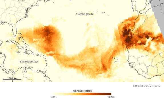
Saharan Sand Reaches Southeastern USA. NASA's
Earth Observatory has more details: "
Sand
in the Sahara Desert doesn’t always stay put. Tiny particles can be
lofted into the air, eventually landing elsewhere in that vast sandy
desert. Sometimes dust from the Sahara traverses an entire ocean. That
was what happened in July 2012, when a dust plume extended across the
Atlantic Ocean toward the Caribbean Sea and Florida. This color-coded
map is made from data collected by the Ozone Mapper Profiler Suite (OMPS) on the SuomiNational Polar-orbiting Partnership
(S-NPP) satellite. It shows relative aerosol concentrations across the
Atlantic Ocean on July 21, 2012. Lower concentrations appear in
yellow, and greater concentrations appear in dark orange-brown. Areas
in grey represent data that have been screened out due to sunglint
(reflection of sunlight) or other factors."
"Ask Paul". Weather-related Q&A:
Paul
"Much is said about the heaviest rains in six
decades in Bejing, but I cannot find anywhere in the articles how much
fell. Any ideas?"
Jon Miller
Jon - Here's an excerpt from a story at
msnbc.com: "
Meanwhile,
Beijing suffered through a 10-hour downpour over the weekend that
dumped 6.7 inches of rain in parts of the city and as much as 18 inches
in the worst hit parts on the outskirts of Beijing in what is being
called the worst flooding to hit the Chinese capital in six decades."
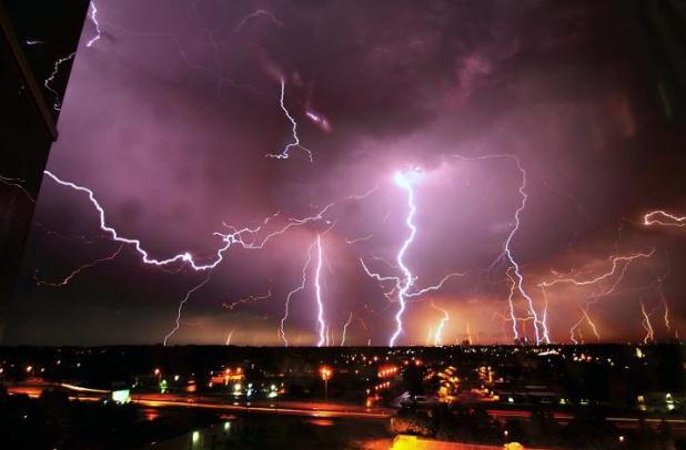
Hi Paul and crew.
"I left work in Eden Prairie last night
about half-past midnight, and headed home to Faribault. What a light
show in the south! After stopping midway for gas and a snack at
Lakeville Kwik Trip, I continued south on 35. The closer I got to
Faribault, the more lightning flashed almost constantly. After the
Northfield exit, I felt like I was in a huge Faraday Cage. Lightning was
everywhere, including a couple right in front of me. They seemed so
close to the road, I half expected fires when I passed the spot. It is
not often my commute is so exciting...."
Daniel Jensen
Faribault
* photo courtesy of Eric Jaakkola
Dan - Glad you got home safe and sound. Yes,
that was quite a display Monday night, strong enough to knock our power
out for 5 hours. There seems to be a correlation between the number of
lightning strikes and the potential for severe weather. Any storm that
produces more than 25 strikes/minute is probably severe, capable of
hail, damaging winds and torrential rains. As much as 2-3" of rain fell
out of some of those storms. The higher the dew point, the more water in
the air, the greater the amount of fuel available to power up some
memorable storms!
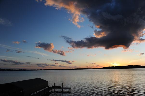
Could "Awe-Therapy" Make Us Nicer? What is awe-therapy, you ask? Great question. It's those rare moments in your life when there are no words. Here's a better explanation from
theweek.com: "
A
breathtaking view could be just what the doctor ordered. A new study
from Stanford University finds that an awe-inspiring experience — or a
moment that overwhelms to the point that time seems to stand still —
can improve our mental state and make us nicer people overall. What
exactly is "awe therapy," and why are perfectly reasonable researchers
lending the concept credence? ....Stanford psychologists say that awe
is the emotion we feel when we encounter something so beautiful that it
changes our perspective, at least for the moment. That could range
from finding yourself entranced underneath the northern lights to
gazing out at a perfect sunset over the Pacific to feeling tiny
underneath a moonlit sky full of stars."
Dunkin Donuts Takes A Page Out Of Disney's Book: Sprays Coffee Scents Into Buses. Hey, I'm being manipulated into craving a sugar donut (but I don't mind too much). The head-scratching article from thenextweb.com; here's an excerpt: "
Here’s
what’s new in the world of awesomely invasive advertising: Dunkin’
Donuts is now spraying the scent of coffee into South Korean buses in
order to attract new customers. The technology, as reported by BostInno,
works as such: #1. An aromatic sprayer is installed and outfitted with
Dunkin’ Donuts coffee smell. #2. Whenever the company jingle is played
over the bus radio, the device is triggered, and customers feel the
need for a fresh brew."
85 Amazing Animal Photobombs (Slide Show). O.K. My
dear sister in Pennsylvania sent me this - as a pet lover how I can I
resist. If you've had enough news and need a chuckle check out this
funny photo essay from
Huffington Post: "
At this point, it's pretty clear that animals are by far the best photobombers out there (for proof, just check out our Twitter avatar). Even since last month's slideshow,
the animal kingdom has been hard at work ruining people's pictures (or
making them way, way better, which is the way we prefer to look at
it). Check out 40 new and hilarious animal photobombs from the likes of
dogs, cats, llamas, dolphins and more at the top of the slideshow
below, plus 45 from last month that are still LOL-worthy."
Uncle Ben's To Compete Against Apple With Brand New Smartphone. Uh huh. Then again, the way things are going, I wouldn't rule anything out.
The Onion has more details: "
HOUSTON—Hoping
to boost profits by cutting into the valuable market share currently
occupied by Apple's popular iPhone 4S, top American rice manufacturer
Uncle Ben’s announced plans Tuesday to release its first-ever
smartphone. Uncle Ben's, a company traditionally known for producing
white, whole-grain brown, and flavored rices, confirmed a Nov. 23
launch date for its new "Basmati" phone, a 4G-capable device expected
to serve as the brand’s flagship product as the company makes its entry
into the lucrative mobile technology sector. "Whether it's instant
rice, country-style rice, boil-in-a-bag rice, or smartphones, Uncle
Ben’s has always been committed to innovation," a statement from the
company read in part. "In 1942, we introduced the world to easy-to-cook
parboiled rice."
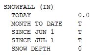
Am I Missing Something Here? I took a look at Tuesday's MSP
climate data
from NOAA and did a double-take. Under snowfall it listed T (trace) for
the month to date, a trace of snow since June 1. One question: huh? Did
I sleep through a freakish outbreak of 90-degree snow flurries?
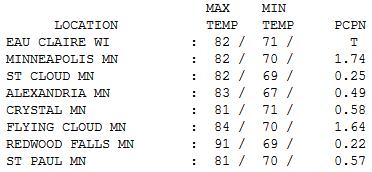
Wettest July 24 On Record For KMSP. I
was impressed by the variation in rainfall amounts yesterday just
across the metro, close to 2" southern suburbs, with only .58" at
Crystal Airport and .25" at St. Cloud. Clouds and rain kept temperatures
cooler; highs ranging from 81 at St. Paul and Crystal to 82 St. Cloud
and 91 Redwood Falls.
Paul's Conservation Minnesota Outlook for the Twin Cities and all of Minnesota:
TODAY: Still hot and humid - risk of a passing
T-storm (best chance central/northern Minnesota). Dew point: 72.
Winds: NW 15+ by afternoon. High: 92
WEDNESDAY NIGHT: Clearing, turning less humid. Low: 68
THURSDAY: Morning sunshine, late day T-storm possible. Better. Dew point: 62. High: 87
FRIDAY: Sunshine, less humidity. A beautiful summer day. Dew point: 58. Low: 63. High: 80
SATURDAY: Sunnier, nicer day of the weekend. Dew point: 61. Winds: S 10. Low: 64. High: 86
SUNDAY: More clouds, unsettled and stickier; few T-storms. Dew point: 68. Low: 68. High: 85
MONDAY: Steamy again, late-day thunder? Low: 70. High: near 90
TUESDAY: Here we go again. Plenty hot. Low: 72. High: 93
Million Dollar Rain
I've never been happier to see red on the old
Doppler radar screen. Some 1-3 inch rainfall amounts were reported over
central & southern Minnesota, enough to put a serious dent in
moderate drought conditions south of the metro.
Summer rains are always fickle: one town picks
up 3 inches, while 10 miles down the road the sun is out, and farmers
feel cheated.
Master Gardener Tricia Frostad has some timely
advice for your garden: let your lawn grow longer; 3 inches is fine.
"Taller grass will help shield the soil and conserve moisture. It will
also reduce weeds (which by the way also take up moisture, so keep your
gardens weeded as well)" she said. Water in the early morning or
evening, and consider mulching; a 3-4" layer of mulch preserves moisture
in your garden. My plants shudder when they see me coming, but I'm
trying.
The heaviest storms are winding down; 90+ heat
possible today, in spite of a wind shift to the northwest. By Thursday
it should feel tolerable, as dew points dip into the 50s.
A dry sky lingers Friday & Saturday; more
storms Sunday. Highs flirt with 90 again next week. I'm feeling better
about my forecast of 35 days above 90.
Better isn't quite the right word.
Climate Stories....
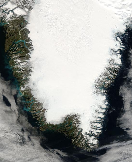
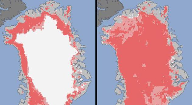
Satellites See Unprecedented Greenland Ice Sheet Melt. Some troubling details from
NASA's JPL,
the Jet Propulsion Laboratory; here's an excerpt: "For several days
this month, Greenland's surface ice cover melted over a larger area
than at any time in more than 30 years of satellite observations.
Nearly the entire ice cover of Greenland, from its thin, low-lying
coastal edges to its 2-mile-thick (3.2-kilometer) center, experienced
some degree of melting at its surface, according to measurements from
three independent satellites analyzed by NASA and university
scientists. On average in the summer, about half of the surface of
Greenland's ice sheet naturally melts. At high elevations, most of that
melt water quickly refreezes in place. Near the coast, some of the
melt water is retained by the ice sheet, and the rest is lost to the
ocean. But this year the extent of ice melting at or near the surface
jumped dramatically. According to satellite data, an estimated 97
percent of the ice sheet surface thawed at some point in mid-July.
Map credit above: "
Extent of
surface melt over Greenland's ice sheet on July 8, 2012 (left) and July
12, 2012 (right). Measurements from three satellites showed that on
July 8, about 40 percent of the ice sheet had undergone thawing at or
near the surface. In just a few days, the melting had dramatically
accelerated and an estimated 97 percent of the ice sheet surface had
thawed by July 12. In the image, the areas classified as "probable
melt" (light pink) correspond to those sites where at least one
satellite detected surface melting. The areas classified as "melt"
(dark pink) correspond to sites where two or three satellites detected
surface melting." Image credit: Jesse Allen, NASA Earth Observatory and Nicolo E. DiGirolamo, SSAI and Cryospheric Sciences Laboratory."
Sea Level Rise And Greenland Ice Melt. More on the implications of accelerating ice melt on Greenland from
scienceblogs.com; here's an excerpt: "...
Some
have estimated that the Greenland Ice sheet can mostly melt off if
there is enough Carbon in the atmosphere. If it did, sea levels would go
up about 6 or 7 meters. During the last inter-glacial, sea levels were
not THAT much higher than they are now, but they were close. Between
the Antarctic and Greenland, there’s plenty of ice to convert to sea. I
am concerned that melting conditions in Greenland could cause a lot of
that ice to become sea water in a much shorter period of time than
current, in my view conservative, predictions suggest. If something
similar happens in the Antarctic … a wider and more even spread of
warmth in the Southern Hemisphere most years … than there would be more
than enough melt-water to produce surprising and catastrophic results."
Climate Scores. How are Minnesota legislators doing on the climate change issue? Click over to
Climate Scores
and find out for yourself. One of the most important things all of us
can do is make our voices heard with our representatives, in St. Paul
and in Washington D.C. More from Climate Scores: "
We believe in
holding Congress accountable on climate change. Find out how your
representative has been voting on climate change issues by clicking on
the map (above)."
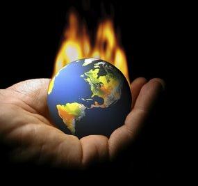
Will Fire And Brimstone Help In The Fight Against Climate Change? Here's a portion of an illuminating post from
philly.com: "
Leave it to some good ol’ hellfire to get the American public believing again in climate change. According to polling
done last week by the University of Texas, 70 percent of Americans now
believe that the climate is changing, compared to 65 percent just a
few months back, and up from a low of 52 percent during the record
winter snowfalls of 2010. These changes, of course, come in the wake of
record heat across the United States and a widening drought now
afflicting 29 states and covering 61 percent of the continental U.S. With the drought damaging crops and driving grain prices up, food prices are likely to rise in the coming months."
Climate Change's Costs Hit The Plate. The impact on
agriculture? This summer may be a cautionary tale. We've always had heat
waves and drought, but scientists are increasingly concerned that we're
loading the dice in favor of more frequent and intense drought. Here's
an excerpt from
theglobeandmail.com: "
In
the past few years, agricultural scientists have shown that crops
critical to humankind’s caloric supply – including corn and soybeans –
are extremely sensitive to even short periods of high temperature.
Output of these crops increases as the temperature rises to about 30
Celsius, but then it falls sharply as the temperature keeps rising. For
instance, just one day of 40-degree (Celsius) weather will produce a
7-per-cent drop in the annual yield of corn compared with its yield if
the temperature stays at 29 through the growing season. In the past,
40 degrees might have seemed unusual, but nowadays it isn’t. In recent
weeks, temperatures have topped this level repeatedly in key
corn-growing states such as Nebraska, Iowa, Illinois and Indiana. The
U.S. grain-growing regions are being hit, in fact, by a particularly
brutal combination of drought and high heat."
Drought Grips Nation And Shows What Climate Change Does To Our Communities.
Huffington Post has the story; here's an excerpt: "
The
worst drought in 50 years has descended on America and left
communities struggling to cope. "If no significant rain comes, I will
have to go out of business," explained Karen
Harrelson, one of many farmers and ranchers fighting to hang on
through the drought. "I just don't have any grass and won't be able to
afford the hay prices." She has already been forced to sell 100 of her
250 herd of cattle. The summer from hell continues to bring wave after
wave of extreme weather events, and each one provides yet another
example of what climate change is doing to our families and businesses.
After the fires and heat waves, came the drought. The National Weather
Service's Drought Monitor said more than half the country is in its grip and nearly 1,300 counties have been designated disaster
areas as a result. The number of lives impacted and the amount of money
lost will be tallied for months and years to come."
Photo credit above: Elizabeth Flores, Star Tribune.
Environmentalists Target 5 Republicans Who Question Humans' Impact On Climate. Here's an excerpt from a story at
The Washington Post: "
The League of Conservation Voters
will launch a $1.5 million campaign Tuesday targeting five House
Republicans who question the connection between human activity and climate change, in an effort to test whether the issue can sway voters. Prominent conservative Republicans have challenged the scientific consensus
that greenhouse gas emissions from fossil fuels and other sources are
transforming the Earth’s climate. But it has not emerged as a central
issue in a national political campaign, and President Obama, who pushed
unsuccessfully for national limits on greenhouse gas emissions at the
start of his term, has played down the issue over the past two years." (File photo above: Wikipedia).
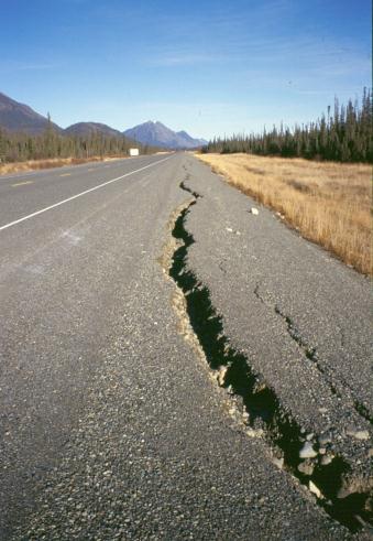
With Warming, Peril Underlies Road To Alaska. The
Alaska Highway is under assault from a variety of factors, including
warming and rapid melting of permafrost. Here's an excerpt from
The New York Times: "...
But
today the Alcan faces challenges that could not have been predicted
when it was built. By far the biggest is permafrost, the permanently
frozen ground that underlies much of the road. As the climate warms,
stretches of permafrost are no longer permanent. They are melting —
leaving pavement with cracks, turning asphalt into washboard and
otherwise threatening the stability of the road. Not all of the melting
is due to climate change.
Road improvements like heat-absorbing dark pavement alter conditions
in the ground beneath, particularly if a lens of ice lies close to the
surface. Merely removing roadside vegetation to uncover dark soil can
have a melting effect."
Photo credit above: "
In an undated handout photo, cracking
on the shoulder of the Alaska Highway north of Burwash Landing, Yukon.
The highway, built during World War II, is now facing big challenges,
including the effects of climate change on the underlying permafrost.
(Government of Yukon via The New York Times)."


No comments:
Post a Comment