90 F. high on Thursday in the Twin Cities.
26 days at or above 90 so far in 2012.
July: 14th month in a row of above-average temperatures in the Twin Cities.
83 F. average high for August 2.
88 F. high on August 2, 2011.
Friday Severe Risk. SPC has the eastern Dakotas and
much of Minnesota in a slight risk - the best chance after 5 or 6 pm, as
a squall line sweeps from west to east, forming 100-200 miles ahead of
the most vigorous cool front since mid June.
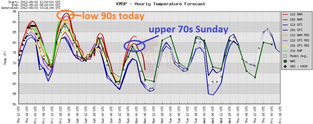 Last 90+ In Sight.
Will we see more 90s by mid-September? The rate this year is going I'd
count on it. But temperatures cool significantly over the weekend, by
Sunday highs hold in the 70s over most of Minnesota (for the first time
since June 25).

 Tour de Tonka.
 Saturday is the big day, the annual
Tour de Tonka bike ride.
A few showers are possible, especially morning hours, but the sun
should peek thru, a cool, comfortable breeze behind a cool front. BTW,
that's WeatherNation TV's Susie Martin (upper right), joined by
meteorologist Kristin Clark (upper right). Good luck to everyone
participating!
 Weekend Details
.
The ECMWF model keeps a few showers around thru midday Saturday as
winds swing around to the west/northwest. Sunday still appears to be the
sunnier day of the weekend, winds easing a bit by afternoon.
 Extended Outlook: Not As Hot.
Call me a naive optimist, but I suspect that the worst of the
eye-watering, hair-curling heat is behind us now. After more 90s today
we enjoy a hint of September over the weekend, warming into the mid to
upper 80s Monday, again Thursday, based on ECMWF guidance. The best
chance of rain:
Saturday, again next Friday.
"
As of this week, nearly half of the nation's corn crop was rated
poor to very poor, according to the USDA's National Agricultural
Statistics Service. About 37 percent of the U.S. soybeans were lumped
into that category, while nearly three-quarters of U.S. cattle acreage
is in drought-affected areas, the survey showed." - excerpt of a Huffington Post article below.
"
Jonathan Overpeck, professor of geosciences and atmospheric
sciences at the University of Arizona [said] “The extra heat increases
the odds of worse heat waves, droughts, storms and wildfire. This is
certainly what I and many other climate scientists have been warning
about.” - excerpt from The Hill, details below.
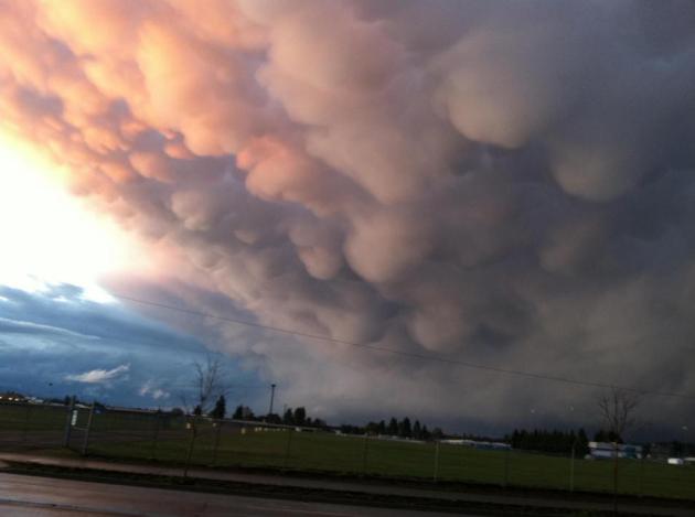
Severe threat later today. A small percentage of
T-storms may produce large hail, damaging winds, even a few isolated
tornadoes. Photo above courtesy of Randy Widmayer.
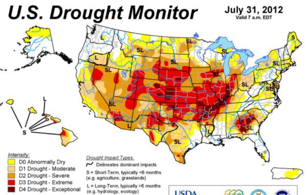
U.S Drought 2012: Half Of Nation's Counties Now Considered Disaster Areas.
In a drought there are no warnings, no evacuations, no volunteers to
help people restore their lives or businesses. It is a slow-motion
catastrophe, and much of America's heartland continues to wither away in
the worst drought since 1936. This will probably surpass 1988 to become
the worst U.S. drought in nearly 80 years. Details from
Huffington Post: "ST.
LOUIS -- Nearly 220 counties in a dozen drought-stricken states were
added Wednesday to the U.S. government's list of natural disaster areas
as the nation's agriculture chief unveiled new help for frustrated,
cash-strapped farmers and ranchers grappling with extreme dryness and
heat.
The U.S. Department of Agriculture's addition of the 218
counties means that more than half of all U.S. counties – 1,584 in 32
states – have been designated primary disaster areas this growing
season, the vast majority of them mired in a drought that's considered
the worst in decades. Counties in Arkansas, Georgia, Iowa,
Illinois, Indiana, Kansas, Mississippi, Nebraska, Oklahoma, South
Dakota, Tennessee and Wyoming were included in Wednesday's
announcement. The USDA uses the weekly U.S. Drought Monitor to help
decide which counties to deem disaster areas, which makes farmers and
ranchers eligible for federal aid, including low-interest emergency
loans.
* NOAA's latest U.S. Drought Monitor is
here.
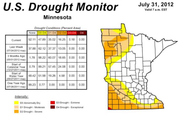
Minnesota Drought Update. The drought has eased a
bit, statewide, at least in terms of coverage area. The percentage of
the state described as "abnormally dry" or worse has shrunk from 62%
last week to 47% this week. But the region of severe drought in far
southern, southwestern and northwestern Minnesota has expanded slightly,
from 13% to 16% this week, a touch of extreme drought into far
southwest Minnesota. More details
here.
Drought Details. Here's more information on the intensifying drought across the USA, courtesy of the
U.S. Drought Monitor: "
The
July 24 U.S. Drought Monitor showed widespread intensification of
drought through the middle of the country, according to the National
Drought Mitigation Center at the University of Nebraska-Lincoln. The map
also set a record for the fourth straight week for the area in
moderate drought or worse in the 12-year history of the U.S. Drought
Monitor. The July 24 map put 53.44 percent of the United States and
Puerto Rico in moderate drought or worse, up from 53.17 percent the
week before; 38.11 percent in severe drought or worse, compared with
35.32 a week earlier; 17.2 percent in extreme drought or worse,
compared with 11.32 percent the week before; and 1.99 percent in
exceptional drought, up from .83 percent the preceding week.
“We’ve seen tremendous intensification of drought through
Illinois, Iowa, Missouri, Indiana, Arkansas, Kansa and Nebraska, and
into part of Wyoming and South Dakota in the last week,” said Brian
Fuchs, a climatologist and U.S. Drought Monitor author. “The amount of
D3 developing in the country has increased quite a bit for each of the
last several weeks.”
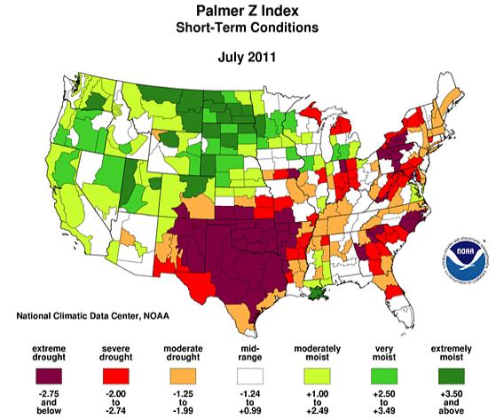
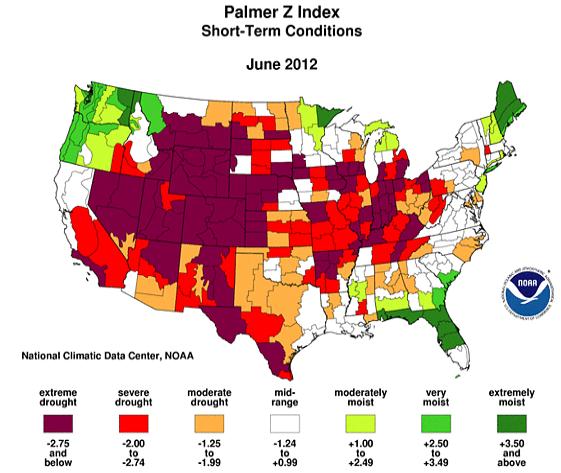
Images Above: "Palmer Index". Here's a good explanation of
NOAA's Palmer Index:
"The Palmer Z Index shows how monthly moisture conditions depart from
normal (short-term drought and wetness). The maps show the geographical
pattern of the moisture anomalies for the last 12 months. On these maps,
the red shading denotes dry conditions, while the green shading
indicates wet conditions."
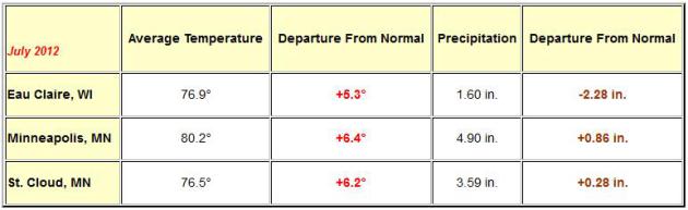
An Amazing 14 Month Warm-Weather Run. Details from
the local NWS office: "For the Twin Cities...here's a look at the
departure from normal for the average monthly temperature, and its
historical ranking, back to June of 2011.
|
Month
|
Temperature Departure from Normal
|
Rank
|
|
July
|
6.4
|
2
|
|
June
|
3.5
|
10
|
|
May
|
4.5
|
11
|
|
April
|
2.5
|
23
|
|
March
|
15.5
|
1
|
|
February
|
6.8
|
13
|
|
January
|
7.7
|
8
|
|
December
|
8.1
|
13
|
|
November
|
5.6
|
9
|
|
October
|
6.5
|
9
|
|
September
|
0.9
|
42
|
|
August
|
2.4
|
19
|
|
July 2011
|
5.6
|
6
|
|
June 2011
|
1.1
|
40
|
"...
it's been so hot in Minnesota, even ifs famous lakes provide
little relief....We have temperatures probably pushing 90 degrees in
some of our shallow lakes....causing fish kills in at least 25 lakes." - from Wednesday's NBC Nightly News with Brian Williams.
89.9 F. average high temperature in the Twin Cities during the month of July. Only two months have been warmer, in 1988 and 1936.
May, 2011. Last time the Twin Cities, St. Cloud and Eau Claire all had below average temperatures for a given month.
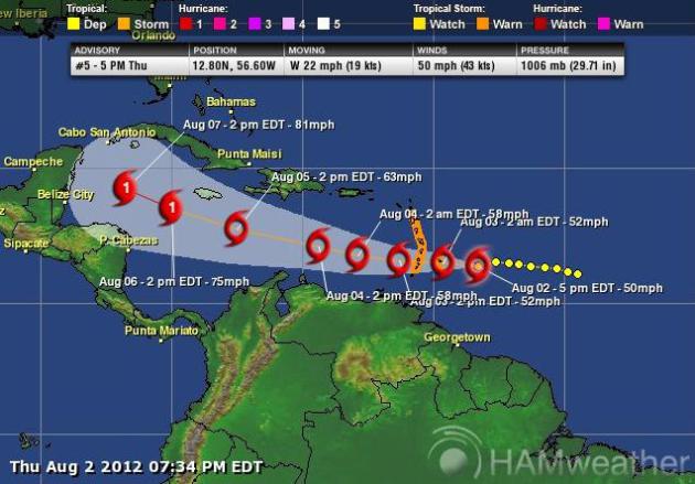
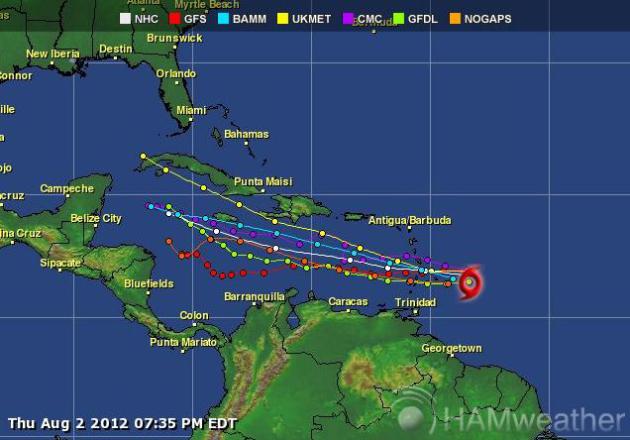
Tropical Storm Ernesto NHC is tracking Tropical
Storm Ernesto, forecast to push south of Puerto Rico and the Dominican
Republic, strengthening to Category 1 hurricane status by early next
week well south of Cuba. Ernesto may move into the Gulf of Mexico; it's
simply too early to speculate whether the storm will impact the USA. Map
courtesy of
Ham Weather and Alerts Broadcaster.
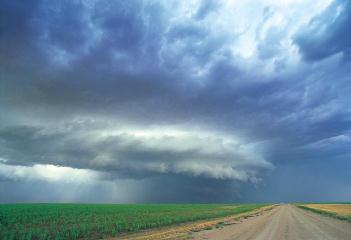
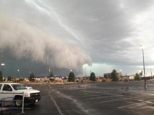
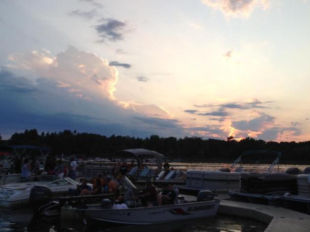
Shelf Cloud. Thanks to WeatherNation TV
meteorologist Bryan Karrick for sending in this photo of a severe storm
pushing toward Carver, Minnesota. Severe storm warnings were issued for
parts of the south metro Wednesday evening.
24 tornadoes, nationwide, in July,a new record low -
the result of persistent heat and drought. Canada saw more tornadoes
than the USA last month, which is highly unusual. Details from Climate
Central below.
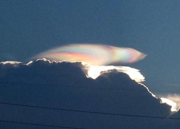
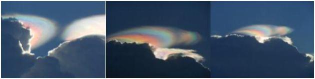
What Would Produce An Effect Like This? A terrific example of "iridescent clouds" below.
"
At this point, temperature readings alone aren't necessary to validate climate change, since seasonal events like flower blooms and bird migrations are shifting, Peterson said. "If
we did not have any thermometers here on the planet, we would know
darn well that it is warming because of all these other indicators." - from an article at
LiveScience.
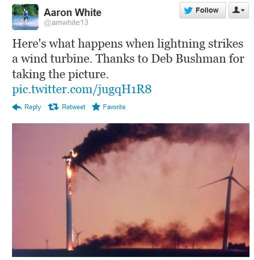
Don't Stand Next To The Wind Turbine. Thanks to Severe Studios for passing this along. Original tweet
here.
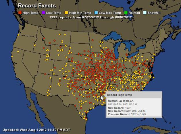
Last Week's Worth Of Warm Weather Records. According
to NOAA, 1337 warm weather records (maxes and mins) were set,
nationwide, since July 25. For an interactive map from Ham Weather
click here.
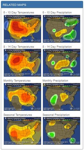
Smart Money? Warmer Than Average. We'll see a break
from the heat and humidity over the weekend, but the 6-10 and 8-14 Day
Outlook is still trending warmer than average for the Upper Midwest, the
worst of the heat shifting into the Intermountain West.
Click here to see full-screen NOAA CPC predictions, courtesy of Ham Weather.
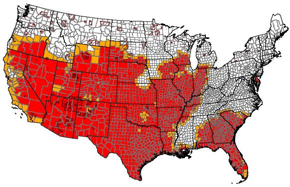
Official Drought Designation Counties From USDA. Over 50% of U.S. counties are now in a major drought. The USDA has more information on drought assistance
here.
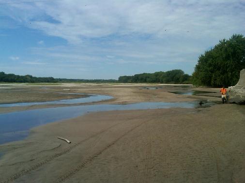
Deepening Drought. This photo (from the USGS) sums it up. That's what's left of the Platte River at North Bend, Nebraska. Not good.
A Look At How Rising Corn Prices Will Impact Prices At The Supermarket. The Star Tribune has the story; here's an excerpt: "
Cornflakes
won't necessarily be more expensive as a result of rising corn prices,
but the milk you pour over them might be. A drought covering two-thirds
of the country has damaged much of the country's corn crops and pushed
grain prices to record levels, triggering fears that a spike in food
prices will soon follow. But there are many factors that determine the
price of goods on supermarket shelves. A diminished corn supply doesn't
mean that all food prices will be affected the same way. In fact,
you're more likely to see higher prices for milk and meat than corn on
the cob. That's because the sweet corn that shoppers buy at a grocery
store is grown differently and not as vulnerable to drought conditions.
As for the corn that's used as grain feed for cows, however, farmers
are paying more as the drought persists."
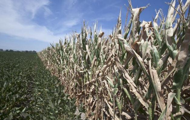
Photo credit above: "
A field of soy beans, left, meets
drought-damaged corn in Mead, Neb., Tuesday, July 31, 2012. Soy beans,
while distressed, are less sensitive than corn to the drought. The
drought covering two-thirds of the continental U.S. had been considered
relatively shallow, the product of months without rain, rather than
years. But a report last Thursday showed its intensity is rapidly
increasing, with 20 percent of the nation now in the two worst stages
of drought up 7 percent from the week before." Photo: Nati Harnik, Associated Press.
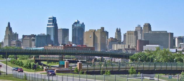
Driest 4-Month Period On Record For Kansas City. Here are a few remarkable details, courtesy of NOAA and Facebook:
- For the month of July, Kansas City received only 0.49″ of rain, which is 3.96″ below normal.
- For the 4 month period of April 1st through July 31st, Kansas City has received just 5.88″, which is 12.60″ below normal.
- This makes this period of time the driest on record for Kansas City beating 1911 by by 0.02″. In that year only 5.90″ fell.
- To put this into a little more perspective the 5.88″ this year
is drier than 1936 by 1.04″, 1988 by 1.42″, 1980 by 2.71″, 1953 by
2.83″, and 1934 by 3.63″. Those years represent the 3rd – 7th driest
April 1st – July 31st periods of time on record at Kansas City. (photo
above: Wikipedia).
Driest July On Record For Sioux Falls, South Dakota. A few details from NOAA:
- July 2012 will go down in the record books as the driest July on record in Sioux Falls.
- Rainfall for the month totaled only 0.24″ at the airport in
Sioux Falls, breaking the previous record of 0.25″ which fell back in
July 1947.
- Normal rainfall for the month of July is 3.09″.
July Weather Summary. Here's a good overview of a very warm month, from the local
Twin Cities National Weather Service: "
July
of 2012 will likely be remembered for near record
warmth. July continued a long standing trend of seeing above normal
temperatures across the area, with most locations seeing temperatures 5
to 7 degrees above normal. In fact, this marks the 15th
consecutive month that all three climate locations have seen above
normal temperatures. One has to go way back to May of 2011 to find a
month where the average temperature for the month was below normal at
all three locations. It was the 2nd warmest July on record for
the Twin Cities (since 1873), the 5th warmest for St. Cloud (since
1893), and the 2nd warmest in Eau Claire (since 1950). In fact, the
lowest temperature recorded at the Minneapolis St. Paul International
Airport during the month of July was 64 degrees."
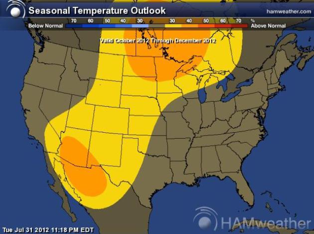
Warm Bias To Continue...? Place your bets. The map
above (from NOAA CPC) shows the (very) extended temperature outlook from
October thru December. Based on a developing El Nino warming phase in
the Pacific, and the mild trends we've seen for the last 12-15 months, I
suspect going warmer than average probably isn't going out too far on a
limb.
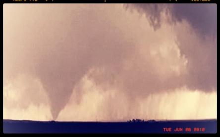
A Silver (Tornadic) Lining. Climate Central's Andrew
Freedman explains why we had a record (low) number of tornadoes,
nationwide, during July - here's an excerpt of a
recent article: "
Thanks,
in part, to the record-setting drought that is gripping much of the
U.S., the country had a record low number of tornadoes for the month of
July, and the lowest number of tornadoes for any May-through-July
period since high quality recordkeeping began in 1954, according to the U.S. Storm Prediction Center
in Norman, Okla. With just 24 tornado reports in July, the U.S. saw
fewer tornadoes this month than Canada did, which is unusual...The
majority of the lower 48 states are currently in the grips of one of
the most widespread and intense droughts in U.S. history, and the
drought itself is inhibiting storm formation by keeping the air drier
than it otherwise would be. The sinking motion caused by a stubborn
“Heat Dome” of High Pressure has also acted as a limiting factor for
storm formation."
Photo credit above: "
A tornado captured near MooseJaw, Saskatchewan on June 26, 2012." Credit: Twitpic/@JeffAdams.
Iridescent Clouds. Thanks to meteorologist Bay
Scroggins in Miami for sharing these very unusual and spectacular cloud
formations over south Florida. What is an iridescent cloud? Here's a
good explanation from
NASA: "
Why would a cloud appear to be different colors? A relatively rare phenomenon known as iridescent clouds can show unusual colors vividly or a whole spectrum of colors simultaneously. These clouds are formed of small water droplets of nearly uniform size. When the Sun is in the right position and mostly hidden by thick clouds, these thinner clouds significantly diffract sunlight in a nearly coherent manner, with different colors being deflected by different amounts. Therefore, different colors will come to the observer from slightly different directions. Many clouds start with uniform regions that could show iridescence but quickly become too thick, too mixed, or too far from the Sun to exhibit striking colors."
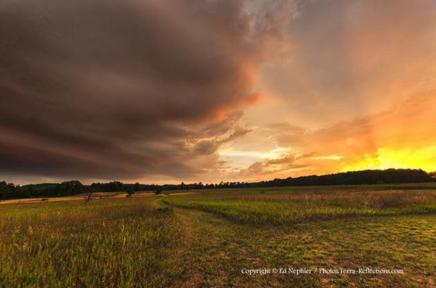
Photo Of The Day. Ed Nepler snapped this terrific
shot out in the (aptly named) town of Bliss, Michigan. Image courtesy of
photos.terra-reflections.com.
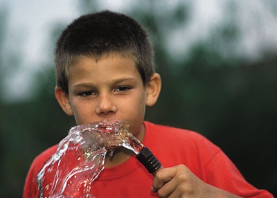
Is Your Garden Hose Toxic? Great. One more thing to worry about. According to this article at
Time Magazine you may want to think twice before drinking from the old garden hose: "
As
a gardener, I’m always sipping water from the hose — especially during
these brutally hot days when I have no choice but to get out and weed.
You can imagine how dismayed I was to come upon research
released by the Ecology Center, which tested water coming from
standard garden hoses and found that it can contain lead, endocrine
disruptors, and neurotoxins, especially in older hoses. Hose fittings
contain brass, an alloy that can contain up to 8% lead. One in three
hoses tested had levels of lead that exceeded drinking water
standards — one as high as 18 times the level. It turns out that hoses
aren’t covered by the same lead laws that govern plumbing
fixtures — even though those hoses are watering our food." (Photo: USDA).
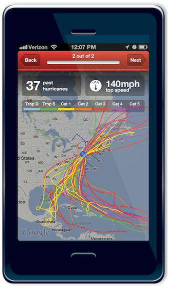
Hurricane App Debuts For Free From American Red Cross. If you have a collection of weather apps on your smart phone you may want to consider adding one more - details from
computerworld.com: "
A
new, free hurricane app from the American Red Cross offers
location-based NOAA weather alerts and a one-touch "I'm safe" message
that users can broadcast via social networks to family and friends in an
emergency. The app became available today, the start of the third
month in the Atlantic Ocean hurricane season, which runs from June 1 to
Nov. 30. The season starts in mid-May for the eastern Pacific Ocean.
The app, dubbed simply "Hurricane," can be found in both the Apple App Store and the Google Play Store for Android by searching for American Red Cross."
Watch Live TV On Your Phone (or Tablet)! No, Really.
Do you want to watch live TV on your phone or tablet? That's a bigger
question - I can definitely see the appeal, especially on tablets,
especially if you can have a DVR capability built in. Here's a snippet
of an intriguing article from c
net.com: "
But
more than two years later and at a cost of around $10 million, the
broadcasters, operating under an alliance called Mobile Content Venture,
are on the verge of making good on their crazy, ambitious plan. Along
the way, big-name players such as NBC and Fox have picked up a cadre of
allies, including handset manufacturers Samsung Electronics and LG
Electronics, and regional prepaid carrier MetroPCS. Dyle will
officially launch in many major markets when MetroPCS sells the first
Dyle-compatible Samsung smartphone, which is expected shortly, CNET has
learned. Dyle declined to comment on the specific timing of the
launch. "The big thing is, this is real," Salil Dalvi, who in addition
to running Mobile Content Venture as co-general manager also serves as
senior vice president of digital distribution at NBC Universal, told
CNET. "There is a real product out there."
Apple's Next iPhone: The Complete Rumor Roundup.
Gizmodo has the latest: "
There's
been so much rumor-hawking and speculation the past few weeks that
whether you're ready or not, we're squarely in the middle of iPhone
season. So here's a quick rundown of everything we think we know about
Apple's next iPhone.
Appearance
We think we have a pretty good idea of what the new iPhone will look like; we've been seeing leaked parts for months now, and recently that has moved up to fully assembled phones, and possibly a whole phone smuggled out of a plant."
Do Olympic Swimmers Pee In the Pool? "Nearly 100 Percent" Do, Says Former U.S. National Team Member. This may be my favorite headline of all time - remind me not to swim in any public pools until further notice. Details from
Huffington Post: "
Carly Geehr has answered one of life's eternal questions: Do Olympians pee in the pool? The answer, is, yes, but the extent to which this is true may disturb many. Geehr, a former USA Swimming National Team Member, decided to provide the icky details when faced with the question on Quora:
Nearly 100% of elite competitive swimmers pee in the pool. Regularly.
Some deny it, some proudly embrace it, but everyone does. The more
interesting question is *when* does said peeing happen?
- Just about the only time you can get away with
peeing during a race is during a breaststroke pullout. You spend
enough time gliding that if you really gotta go, you probably could.
Otherwise, you're too tense and too, well, busy to even think about
peeing."
Photo credit above: "
The USA's Missy Franklin swims in the
second semifinal of the women's 200m backstroke at the Aquatics Center
during the 2012 Summer Olympic Games in London, England, Thursday,
August 2, 2012. Franklin won her semifinal, and moved on to the final." (Chuck Myers/MCT)

 Ditto
Ditto. Another 90?
No
big deal, at least not this summer. After early morning clouds and a
trace of rain in the Twin Cities the sun stayed out most of the day,
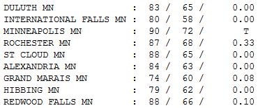
enough for a high of 90 at KMSP. Statewide highs ranged from 74 at Grand
Marais to 88 at St. Cloud. Rochester saw a third of an inch of rain early in the day.
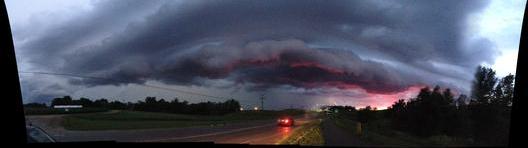
Shelf Cloud courtesy of Mike Leuchtenberg.
Paul's Conservation Minnesota Outlook for the Twin Cities and all of Minnesota:
TODAY: Hot sun, 27th day this year above 90 F. PM storms up north. Dew point: 60. Winds: SE 10-15. High: 92
FRIDAY NIGHT: T-storms likely, a few may be strong to severe. Low: 70
SATURDAY: Unsettled with a passing shower, gusty. Turning cooler and less humid. Winds: W 15-20. High: 80
SATURDAY NIGHT: Sweatshirt weather? Clearing, still breezy..."cool". Low: 62 (50s in greater Minnesota).
SUNDAY: Comfortable sun, very pleasant. Dew point: 53. Winds: NW 15. High: 78
MONDAY: Plenty of sun, pleasant. Dew point: 56. Low: 63. High: 85
TUESDAY: Blue sky, a bit cooler. Low: 65. High: 82
WEDNESDAY: Partly sunny, still quiet. Low: 64. High: 83
THURSDAY: Warmer, chance of thunder. Low: 66. High: 88
Shifting Gears
Breaking news: you may need a "sweatshirt" or
"light jacket" by Saturday night, especially if you're heading up north.
The first puff of autumn is brewing for the weekend, a chance for all
of us to catch our breath.
The greater the contrast in temperature, the
stronger winds have to blow to keep the atmosphere in a state of
equilibrium. Low-level wind shear may whip up severe storms by tonight;
large hail and damaging winds can't be ruled out. 90s are likely today
(27th day this year), but cool, comfortable 70s are imminent. A chance
to exhale.
48 percent of Minnesota is abnormally dry (or
worse), down from 62 percent last week). That's good news, but the area
covered by severe drought rose from 13 to 16 percent.
More than half the country has been declared a
drought disaster; a slow-motion crisis for agriculture, impacting food
supplies & prices well into 2013. Unlike other weather disasters
there are no evacuations, no tearful survivors - but the impact will be
equivalent to 2 or 3 hurricanes; possibly approaching $50 billion before
it's all over.
I'm counting my blessings, atmospheric and otherwise. Minnesota is in better shape than much of America.
I'm ready for a genuine cool front!
Climate Stories...
Extreme Weather From Climate Change Increases Urgency Of Pollution Reductions.
As they say, the writing is on the wall. Will Congress (or President
Obama) do anything about it? I'm not holding my breath. Here's an
excerpt from
The Hill: "....
Climate
science deniers argue that no single weather occurrence is definitely
caused by climate change. However, it is the wrong question to ask
whether global warming caused a specific record smashing weather event.
Dr. Kevin E. Trenberth of the National Center for Atmospheric Research
found that “all weather events are affected by climate change because
the environment in which they occur is warmer and moister than it used
to be.” Climate change makes heat waves longer and more intense. This
in turn makes droughts longer and more intense, which then makes
wildfire seasons longer and more intense. And warmer temperatures yield
more water vapor in the atmosphere, which makes rainstorms more
intense."
Conversion Of Climate Change Skeptic Not Likely To Sway GOP. Here's an excerpt of an article from the
L.A. Times: "
Are two of the left’s most useful villains, Charles and David Koch,
not quite as unredeemable as liberals believe? Could it be they might
change their minds about climate change and admit that it is real? UC Berkeley
physics professor Richard A. Muller says that, after years of paying
for studies by global warming skeptics, the Koch brothers honestly want
to get the science clarified. They helped fund Muller who, only three
years ago, doubted that the Earth was heating up to dangerous levels due
to human activity. Now, with his Koch-funded research complete, he has
reversed himself. In a column published in the New York Times, Muller
wrote, “Call me a converted skeptic."
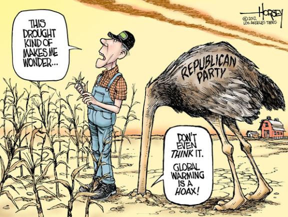
Cartoon credit above: "
Republicans heads are buried in the climate change sand (David Horsey / Los Angeles Times / August 2, 2012)."
Climate Change On Back Burner. The forecast calls
for severe apathy from bickering politicians in Washington D.C. Keep
your expectations low and you'll never be disappointed, right? Here's an
excerpt from a story at
politico.com: "
The
planet may be getting hotter, but Washington’s debate on climate change
isn’t heating up. Amid a summer marked by droughts, wildfires, record
temperatures and freak storms, Congress is squeezing in just one
hearing on the changing climate before it dashes out for a hot August
recess. And that hearing, set for Wednesday, is unlikely to be a
show-stopper: No federal officials will testify, and no big-name
witnesses will appear — none of the elements that could help this
gathering compete for an Olympics-mad public’s attention. It’s a
reminder of how much things have changed for Democrats in Congress
since their hopes for passing a major cap-and-trade bill died in 2010,
reducing the entire climate issue to second-tier status. Now,
Republicans are eager to argue, Democrats are reluctant to even talk
about the issue in an election year."
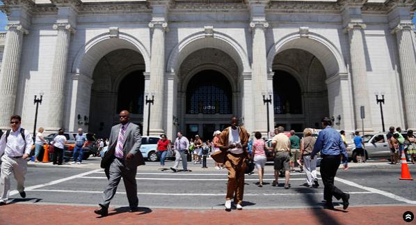
Photo credit above: "
This summer's record-high temperatures could help bring attention to the issue". | AP Photo
Skeptics, Contrarians And Deniers Of Climate Change. Here's an excerpt of a Doug Craig post at
redding.com: "
Bob Baker reads Juan Cole and from the looks of it I should too. Like a lot of us, Mr. Cole was impressed with Dr. Richard Muller's public conversion from skeptic to alarmist. And wrote a nice, long piece
worth taking the time to read. First, some definitions. A global
warming or climate change alarmist, from my perspective, is someone who
is alarmed at the idea that we are systematically destroying the
crucial ecosystems that birthed Earth's various life forms including Homo sapiens. I
am an alarmist. I am alarmed. If your house is on fire, you would
want me to be alarmed and to sound the alarm. To be an alarmist is to
be alert, aware, and awake and willing to alert others when a viable
threat is present. I am also a skeptic which means I am not alarmed by
matters that cannot be proven scientifically. Human-caused climate
change is supported by science, as Muller states."
Should Accountability For Global Warming Be Linked To Crimes Against Humanity? Huffington Post has the Op-Ed; here's an excerpt: "
We
define as having criminal intent any person who calculates that there
is a definite possibility their actions will result in harm to others.
Equally, we define as criminally negligent anyone who is aware that an
individual is likely to harm others but who ignores the situation. In
the not-too-distant future will politicians who intentionally ignore
global climate change, or who obstruct action to implement conscientious
policies to prevent deterioration of climate conditions, be deemed
criminally negligent? The scale of death and destruction resulting from
global warming may potentially exceed losses due to genocides and world
wars. We need discussion of legal and moral accountability for gross
negligence when it comes to destruction at this level."
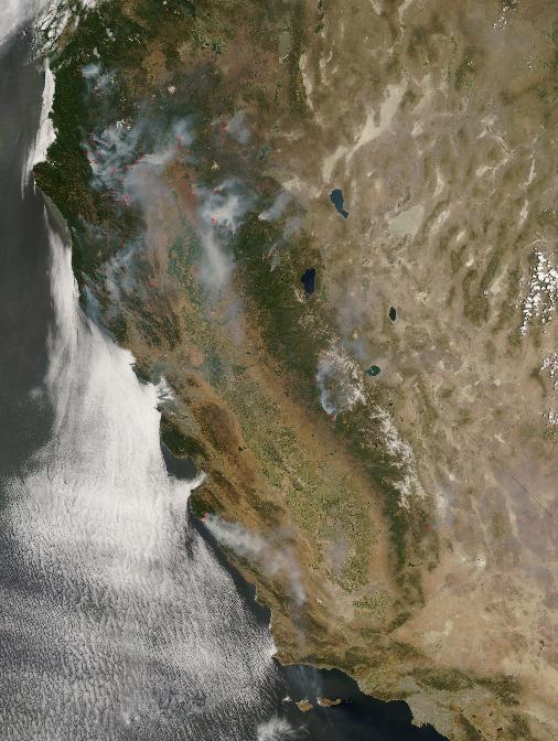
California Prepares For Harsh Realities Of Changing Climate. Here's an excerpt of a recent story at
mercurynews.com: "
Climate
change is real and unfolding, and the outlook for California is bleak,
according to new state-sponsored studies. Released Tuesday, the studies
warn that California can expect more scorching heat waves, severe
wildfires and strain on the electric grid as the Earth warms and sea
levels rise along the state's 1,100-mile long coast. Higher
temperatures in the coming decade mean that many more of the state's 37
million people will depend on air conditioning -- increasing demand for
electricity by up to 1 gigawatt during hot summer months. One gigawatt
is roughly the size of two coal-fired power plants and is enough
energy to power 750,000 homes." (Image: NASA).


No comments:
Post a Comment