By Paul Douglas
No, you can't please all the people all the time. Don't waste your time trying. "Paul, this summer has been TOO NICE!" a Nisswa bookstore owner told me Friday. Say what? "Every day has been sunny. No soggy days to bring in the shoppers. Main Street is hurting." Too nice? 5 inches rain over 3 days would qualify as "nice weather" for farmers in southwest Minnesota, suffering thru severe drought.
But bikers at today's Tour de Tonka want light winds and no puddles. Cue the theme from Mission Impossible. All weather, like politics, is local.
The coolest front since June is charging south of the border, whipping up morning/midday showers, maybe a clap of thunder - but skies try to clear this afternoon. Sweatshirt weather tonight - lows dip into the 50s. Fresh air!
High pressure builds into Minnesota Sunday, meaning more sun, a stiff breeze and a dry sky; the nicer day. We'll see more 80s next week, but the pattern is finally shifting, the heat wave migrating into the western USA.
Ernesto may push into the Gulf of Mexico next week, reaching hurricane strength.
But for now I'm feeling better; our weather is becoming "un-stuck". The worst of the heat wave is behind us now.
______________________________________________________________________________________________
Todd's Conservation MN Outlook for the Twin Cities and all of Minnesota:
SATURDAY:Unsettled start with a passing shower or thundershower,. Slight chance of a passing shower or sprinkle in the afternoon. Turning cooler and gusty with less humidity. Winds: WNW 15-20. High: 80
SATURDAY NIGHT: Sweatshirt weather? Clearing, still breezy..."cool". Low: 58 (Low 50s in greater Minnesota).
MONDAY: Pleasant, a few more clouds and a little more humidity by afternoon. Slight chance of a spotty shower or storm late. Dew point: near 60. Low: 61. High: 84
TUESDAY: Blue sky, a bit cooler. Low: 65. High: 83
WEDNESDAY: Afternoon clouds develop, slight chance of a late day shower. Low: 64. High: 84
FRIDAY: Unsettled. still mild. Low: 66. High: 83.
______________________________________________________________________________________________
Greatest Olympian Ever?
I've heard the phrase "Greatest Olympian
ever" tossed around quite a bit when it comes to USA swimmer Michael
Phelps. I can think of MANY great USA Olympians from the past, but no
other Olympian has claimed as many as he has! Thanks to @SummerSanders_
for the picture below from London during Phelps' last SOLO finish
during these games, a race in which Phelps won gold. Congrats again to
Michael Phelps!

Elsewhere in the Solar System
Keeping an eye on Curiosity! NASA expects
the Mars explorer Curiosity to arrive on the red planet sometime on late Sunday. Here's to hoping for some amazing images, data and theories in
the near future!
"Late Sunday night, the 1-ton Curiosity
rover's spacecraft will barrel into the Red Planet's atmosphere going
about 13,000 mph (21,000 kph). A huge parachute will deploy about 7
miles (11 kilometers) above the ground, slowing the vehicle down to 200
mph (320 km) or so. Rocket engines will then fire, reducing the
craft's descent speed to less than 2 mph (3.2 kph)."

Be one of Curiosity's near 150K Twitter followers @MarsCuriosity

TMI or Too Much Information?
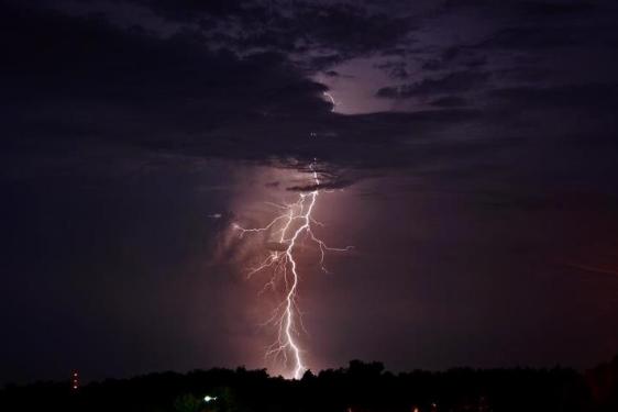
"A study put out by Trojan Brand
Condoms finds that 70 percent of Americans have had sex during
tornadoes and thunderstorms. Seven percent of people admitted to having
sex during a hurricane, including 27 percent of those who live in
Miami."
Thanks to Dale Miscuraca for the picture below from Republic, MO
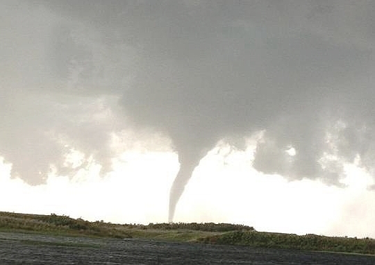
"Saskatoon Canada Seeing Record Tornado Activity in 2012 "
"REGINA — Southern Saskatchewan has seen yet more tornadoes in
what is shaping up to be a potentially record-breaking summer for
twisters in the province.
Environment Canada issued tornado warnings for the RM of Craik and the RM of Huron on Thursday, and received several reports from the public of tornadoes touching down near the town of Tugaske, Sask. about 150 kilometres northwest of Regina. Environment Canada also confirmed that at least one tornado touched down in Douglas Provincial Park, about 180km northwest of Regina.
“The average number of tornadoes between 1991 and 2011 has been 12 per year,” said John Paul Cragg, a warning-preparedness meteorologist for Environment Canada. Cragg added that the current record for tornado touchdowns in that period is 32, set in 1991. Cragg said 2012 may have already broken that mark, with somewhere between 27 and 34 twisters touching down.
Cragg says a warmer-than-average summer has been partly to blame. The warmer temperatures, more moisture than normal in the air and the arrival of low-pressure systems in the mid-afternoon have created ideal conditions for the kinds of thunderstorms that can produce funnel clouds."
Read more from Leaderpost.com HERE:
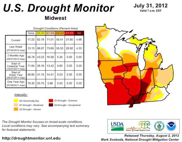
Drought Continues and Worsens
The US Drought Monitor released their
update last Thursday, which showed conditions even worse than the week
before throughout the central part of the country. Folks living in
eastern Minnesota and northern Wisconsin have been getting adequate
moisture, but areas in red (EXTREME DROUGHT and deep red
(EXCEPTIONAL DROUGHT) seem to be getting worse.
"The Midwest: Most of
the region registered above-normal temperatures for the period ending
Tuesday morning. In fact, preliminary data show that July came in at
5-10 degrees above normal for the month of July. The region continues
to be impacted not only by oppressive heat, but also by depleted soil
moisture, desiccated pastures and widespread crop damages, livestock
culling and elevated fire risk. Recent concerns have now turned to
soybeans and water supply as the drought’s duration persists. Some
fared a bit better than others; southern Minnesota and southern and
eastern Wisconsin benefitted the most from rains, leading to general
1-category improvements this week. Rains also fell across northern
Indiana and southern Michigan, leaving things pretty much unchanged
from last week. That said, there is a slight expansion of D3/D4 across
western and central Indiana. Much of southern Ohio and eastern
Kentucky also saw measurable improvement on the order of 1-category
this week, pushing the drought to the west. Longer-term impacts still
remain even given the short-term relief, but parts of eastern Kentucky
and Ohio are seeing a rebound in streamflows, which is a good sign.
In the western half of the region, things continue to worsen across
Missouri and Arkansas, with continued deterioration and encroachment
of D3 and even D4."
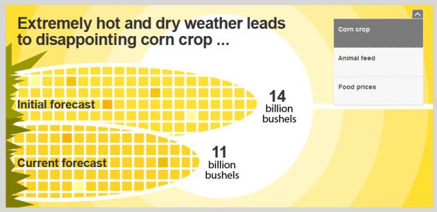
"Why the Drought Will Make Food Cost More"
"The U.S.Department of Agriculture says
food prices will rise because the drought is harming the corn crop.
Corn becomes feed, and as the price of feed goes up, the price of
animals goes up. Meat and poultry prices are affected the most because
feed is the biggest production cost."
"Drought May Cost $20 Billion in Crop Insurance"
"WASHINGTON (CNNMoney) -- As the
drought continues to ravage the nation's corn, wheat and soybean
fields, crop insurance losses are expected to break records.
"It will be a major loss situation,"
said Thomas Zacharias, president of the National Crop Insurance
Services, a lobbying group representing private crop insurers. "The
companies are in the field adjusting claims as we speak."
An economist with the group roughly estimated that losses could top $20 billion and taxpayers will ultimately shoulder most of the cost the nation's scorched fields."

Watching the Tropics
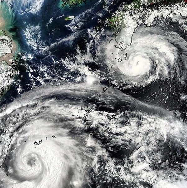
Two Typhoons Saola and Damrey were making headlines in the Philippines, Taiwan and China earlier this week
"In the Philippines, Saola (locally
known as Typhoon Gener) brought torrential downpours earlier this week
forcing 154,000 to evacuate their homes. The storm tracked slowly just
north of the Taiwan after its brief landfall. The Central Weather
Bureau in Taipei reported more than 800 mm [app. 31 ½ inches] of
accumulated rainfall from Tuesday to the present at 35 stations in
northern and central portions of Taiwan. The city of Taipei has
reported about 355 mm [app. 14 inches] of precipitation. Anticipating
high water levels, administrators at Taiwan’s seven major reservoirs
have released water to mitigate flooding.
Meanwhile, Typhoon Damrey has made
landfall along China’s coast farther to the north than Saola. Damrey is
the tenth typhoon of the season and hit northern Jiangsu province with
maximum 1-minute sustained wind speeds of 150 km/h (93 mph, or a
strong Category 1 hurricane on the Saffir-Simpson scale), according to
the Japan Meteorological Agency’s 15:45 UTC advisory. It is moving to
the west-northwest with a forward speed of 25 km/h."
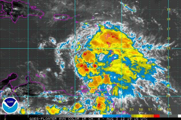
ERNESTO Eases West
Closer to home, ERNESTO continues moving
west northwest toward the Gulf of Mexico. This is something that the
National Hurricane Center is keeping a close eye on, which is forecast
to become a hurricane within the next several days.
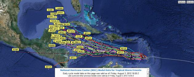
Spaghetti Plot
How about the image below huh?!? Talk about
a meteorological mess. The picture below is a list of several different
models that the National Hurricane Center will be looking at over the
days to come as the storm moves west. It's quite confusing, but the
general trend is through the Caribbean and near the Gulf of Mexico by
next week.
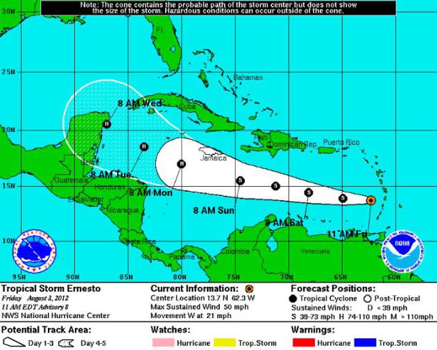
National Hurricane Center Forecast
The NHC's forecast isn't quite as confusing
and takes a similar track to what the spaghetti plots are saying above.
Note how the forecast shows ERNESTO becoming a hurricane by early next
week.
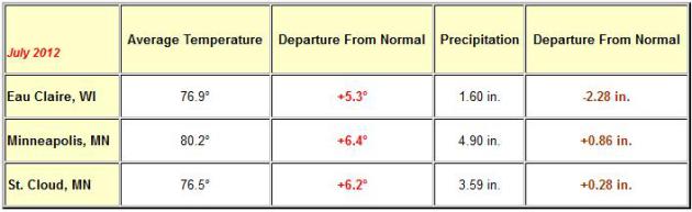
2nd Warmest July on Record @Minneapolis
"It was the 2nd warmest month and 2nd
warmest July on record for the Twin Cities (since 1873), the 5th
warmest for St. Cloud (since 1893), and the 4th warmest in Eau Claire
(since 1893). In fact, the lowest temperature recorded at the
Minneapolis St. Paul International Airport during the month of July was
64 degrees."
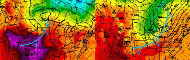
Talk About a Cool Front!
A cool front sliding through the region
this weekend will be responsible for a soggier start to our weekend.
Showers and thunderstorms should exit the area by PM Saturday, making
way for a brilliant, cooler and much less humid Sunday! In fact,
temperatures are forecast to be in the 70s by Sunday, which would be the
first time a high temperature has been below 80F since June 25th at the
MSP Airport. The image below represents temperatures a few thousand
feet off the ground from Friday afternoon (Left) to early AM Sunday
(Right). The resulting surface temperature drop will be nearly 10-15
degrees cooler from Friday to Sunday with a significant drop in humidity
values!
Thanks for checking in, have a great weekend!
Don't forget to follow me on Twitter @TNelsonWNTV

No comments:
Post a Comment