76 F. high in the Twin Cities Sunday.
82 F. average high for August 5.
85 F. high on August 5, 2011.
90+ possible again today, slight chance of thunder tonight as cooler air arrives for Tuesday.
No record heat in sight next 7-10 days.
"
The odds that natural variability created these extremes are
minuscule, vanishingly small. To count on those odds would be like
quitting your job and playing the lottery every morning to pay the
bills," wrote (NASA's James) Hansen." - from a CNN story below.
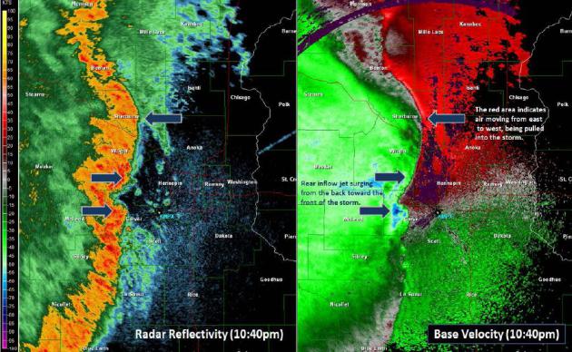
Recap Of Friday Night's Severe Wind Event. Here's a
very good overview of the bow echo/severe wind storm event from Friday night (pdf), courtesy of the local Twin Cities NWS office: "
Multiple
severe thunderstorm warnings were issued as the line of thunderstorms
moved east into south central Minnesota. Many automated weather
observation sites recorded wind gusts from 45 to 55 mph, but severe
criteria winds (58mph or greater, or damage to structures or trees) were
only observed in isolated areas. As the storms moved further east,
warning forecasters debated whether or not to continue issuing warnings
on the storms as very few reports of severe strength winds or wind
damage were received. However, storms began strengthening as they
approached the western edge of the Twin Cities metro area."
* as I referenced below, the high winds knocked our dining room
windows out - that's never happened before. A little too much
excitement...
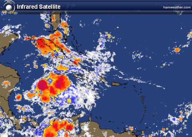
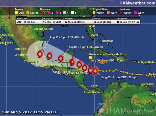
Ernesto Fizzles Tropical Storm Ernesto is not
looking terribly impressive right now - wind shear aloft shredding the
storm's circulation, preventing rapid intensification. NHC models
suggest Ernesto may become a weak, Category 1 hurricane before coming
ashore over Mexico's Yucatan Peninsular (probably passing well south of
Cancun and Cozumel), only a moderate tropical storm after reemerging
into the Bay of Campeche, probably passing south of Texas late in the
week.
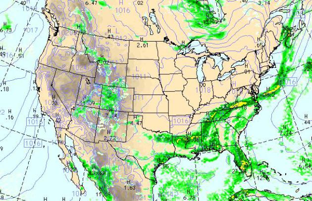
Monday PM Weather Map. the sprawling high pressure
bubble responsible for a spectacular Sunday shifts south and east of
Minnesota today, putting us into a warmer, southwest wind flow at the
surface. On the boundary of cooler, Canadian air and tropical
moisture: heavy showers and T-storms from Louisiana into the Carolinas.
WRF model valid at 4 pm above courtesy of NOAA.
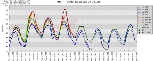
Hot Enough 90 F. is possible in the metro today, a
slight chance of 90 again Wednesday ahead of the next cool front. Our
saving grace: dew points will be low, mostly 50s and low 60s - no long
fetch of moisture from the Gulf of Mexico capable of dredging up (awful)
dew points in the 70s. We do cool down the latter half of this week.
Graphic: Iowa State.
No Heat Records In Sight. Based on the latest ECMWF
model (above) I don't see any records falling by the wayside anytime
soon, although 90 is possible today, again Monday and Tuesday of next
week. The wettest day in sight: Wednesday of this week, but right now I
don't see any widespread, soaking rains looking out 7-10 days.
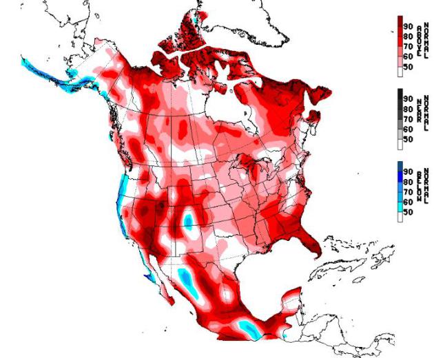
NOAA Drought Outlook. This isn't the weekly Drought
Monitor, but rather a prediction of where drought is expected to expand
or contract. The worst drought since 1956 is forecast to push into North
Dakota and eastern Montana (as well as much of Texas), but some
improvement is likely over the southeast and Arizona, courtesy of a
persistent "monsoon" flow of moisture. NOAA's latest Drought Outlook is
here.
Hot Weather Factoids:
110+ F. weather for three straight days at Oklahoma
City? This is only the second time in recorded history this has happened
- the last year: 1936. Stat: #OKwx.
Saturday was the 4th straight day above 110 F. at OKC - most ever. #OKwx.
24 days at or above 95 F. in Washington D.C. Most to date on record.
Saturday: 39th straight day of 80+ highs in the Twin Cities, second longest 80+ stretch on record.
24 days of 90+ at Denver as of Saturday, tying the longest streak on record.
32 days so far in 2012 with 90+ highs at Cincinnati. 30-year average is 21 days/year.
* thanks to WeatherNation meteorologist D.J. Kayser for tracking down these (remarkable) numbers.
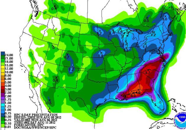
Southeastern Soaking. NOAA HPC's
5-day rainfall prediction
prints out impressive (3-5") amounts from near Pensacola to Raleigh,
North Carolina, generous rains for New England, but little rain west of
the Rockies.
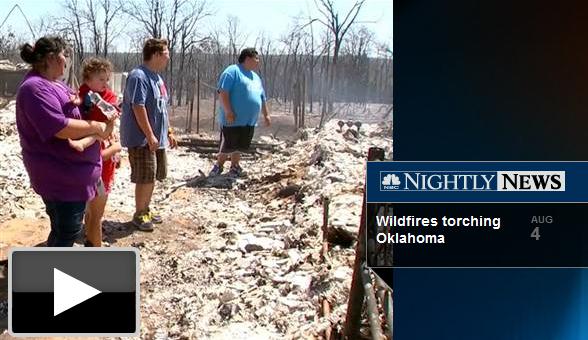
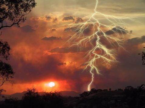
Dozens Of Homes Destroyed In Oklahoma Wildfires. A withering drought is producing ripe conditions for major fires -
NBC News has the story (and video): "
At
least 121 structures, many of them homes, have been destroyed by
wildfires in Oklahoma, officials said Saturday as temperatures topped
100 degrees for a 19th straight day. New evacuations were under way
Saturday as well: Included were the entire towns of Glencoe, population
of around 600, and Mannford, population about 3,000, and surrounding
areas. Thousands were on the move as a fire spread quickly in Creek
County, 20 miles west of Tulsa, the Oklahoma Highway Patrol
reported. Gusty winds were expected in the area on Saturday evening."
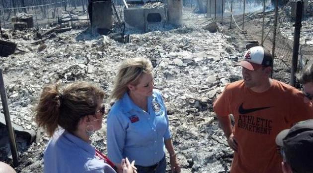
Red Cross Assists Oklahoma Fire Victims. From The Red Cross of central and western Oklahoma
FB site: "
Red Cross CEO Janienne Bella and Governor Mary Fallin touring fire damage in Oklahoma County."
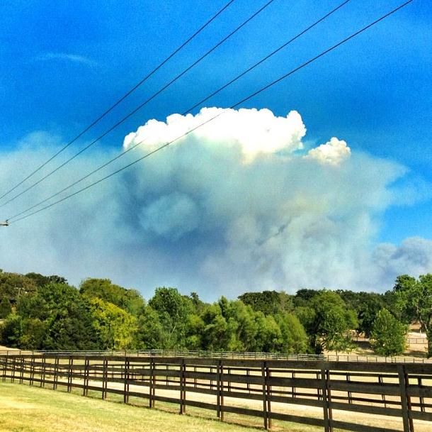
Pyrocumulus. Here's a spectacular example of
"pyrocumulus", updrafts from wildfires providing enough lift for cumulus
formation over Slagherville, Oklahoma. Pic courtesy of
@southshorechick.
Don't Write Summer Off Just Yet. You may need a
light jacket or sweatshirt this morning, and there's little doubt our
weather is transitioning into more of a "progressive" pattern, meaning
more frequent changes, with intrusions of cooler Canadian air coming
with slightly greater frequency and intensity. The heat-pump high
pressure bubble that has been nearly stationary over the Central Plains
and Ohio Valley since late June is weakening, and migrating westward,
allowing the flood gates to open up, pushing cooler fronts farther
south, from the Upper Midwest into New England. That could also mean
more frequent rains for the Corn Belt, but over the Plains the damage
has already been done; wilted crops are past the point of no return,
many farmers plowing under their (stunted) crops. The map above shows
NOAA's "
NAEFS" long-range model for August 12-18.
Latest On Ernesto. Packing 50 mph. sustained winds,
Ernesto is a moderate tropical storm, but latest model guidance keeps
the track of Tropical Storm Ernesto south of the United States, a
potential prolific rain-maker for Mexico, but right now the odds of
impact in South Texas are less than 1 in 5. Maps above courtesy of
NHC and Ham Weather.
Threat Of Hurricanes Looms Over RNC Convention. No, it couldn't possibly happen, right? The odds are small, but not zero, as reported by
Fox News Latino; here's an excerpt: "
The
Republican National Convention is scheduled for late August, prime time
in the Atlantic's dicey hurricane season. Though planners are banking
on years of data that a major storm won't hit, they also have laid out
worse-case scenarios that include canceling if it's clear the 70,000
expected delegates, officials, journalists and protesters would be in
harm's way. Tampa is one of the places in the region most vulnerable to
storm surge. In a major hurricane, floodwaters could reach some 3 miles
inland — Tampa is on a bay, not directly on the Gulf of Mexico — and
storm surge could reach as much as 17 feet. The Tampa Bay Times Forum,
the convention's home, is in an area that would be required to evacuate
if winds exceeded 96 mph."
"Ask Paul" Weather-related Q&A:
"
What was the winter like in the Twin Cities after that hot summer in 1988?"
Thanks Paul,
Ginger Knaff, West St. Paul, MN
Ginger - it's tempting to go back in time to a similar
(blazing) summer for clues about what we can expect this upcoming
winter. After 44 days at or above 90 during the steamy summer of 1988,
we had an old fashioned fall and winter in the Twin Cities; 15.8" snow
in November - a total of 70.1" for the entire winter. It would be (too)
simplistic to say we're in for a tough winter this time around. One big
mitigating factor: El Nino. NOAA is predicting an El Nino
winter, which correlates with milder winters for Minnesota (with less
snow overall). One thing I've learned the hard way: don't buck the
trends. We've had 14 months/row of warmer than average temperatures, and
if I had to gamble and make a long-range (winter) prediction I'd go
with a continuation of milder than normal, with more sporadic snowfall
(based on El Nino). Lately it seems maybe 1 in 4 or 1 in 5 winters is an
old-fashioned (butt-kicking) winter with bitter temperatures and
excessive snowfall. Personally, I hope we see more than the meager 22"
that fell last winter, but I'm not (yet) convinced we're going to see a
70" snowfall this winter. Somewhere between 23" and 70" would be my
guestimate. How's that for vague?
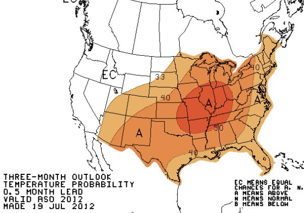
* 3 month outlook from NOAA's CPC (
Climate Prediction Center) shows a lingering warm bias east of the Rockies from August through October. Beyond that, place your bets. Good luck.
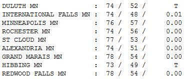
Perfect Sunday.
Warmer temperatures aloft (a more stable atmosphere) meant fewer
clouds, and slightly less wind yesterday, dew points in the 40s creating
almost perfect conditions for outdoor activities. Highs were in the 70s
statewide, ranging from 73 at Hibbing to 77 St. Cloud, 78 Redwood Falls
and Grand Marais. A trace of sprinkles were observed in Duluth and
Hibbing.
Dog Days of August. That's our 1 year old spaniel, Leo, helping me in the kayak - his first time out on the water.
Paul's Conservation Minnesota Outlook for the Twin Cities and all of Minnesota
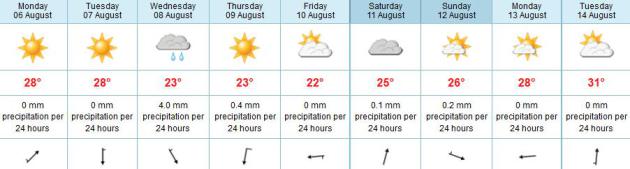
TODAY: Cool start, hot finish. Low humidity. Dew point: 56. Winds: SW 10-15. High: near 91
MONDAY NIGHT: Slight chance of a T-storm. Low: 65
TUESDAY: Partly sunny, a cooler breeze and winds swing around to the north. Dew point: 58. High: 85
WEDNESDAY: Unsettled with a few T-storms. Dew point: 58. Low: 66. High: 89
THURSDAY: Cooler, passing shower or two, turning breezy. Low: 63. High: 79
FRIDAY: Sunny and beautiful. Dew point: 53. Low: 61 (50s greater Minnesota). High: 78
SATURDAY: Some sun, thunder up north? Low: 62. High: 81
SUNDAY: Partly sunny, warmer & drier. Right now it looks like the better day for outdoor plans. Low: 64. High: 83
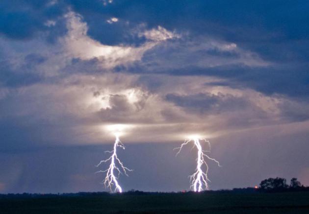
Super-Sized Lightning
Heat has obviously been the big weather story
this summer, interrupted by noisy tantrums of atmospheric madness. I
returned from our cabin only to find our dining room windows blown in by
Friday night's wild straight-line winds.
That's a first.
Severe storm alerting services, resilient
storm-proof materials for homes & vehicles, and new, more
drought/heat resistant strains of wheat, corn & beans will open up
new doors for innovation.
The hotter and wetter the atmosphere - the
greater the potential for crazy lightning displays. More than 25
strikes/minute? The oncoming storm is, in all probability, severe.
A Maryland company called Earth Networks has
deployed a national lightning sensor network, with 1 minute updates
(compared to 4-6 minutes for NOAA Doppler). A sharp, 100-300 percent
uptick in lightning can tip us off to a particularly severe cell, often
preceding a storm warning by 10-15 minutes.
No more free A/C; highs approach 90 F. today.
Wednesday thunder announces the arrival of a reinforcing jab of Canadian
air by Thursday.
It's wrong to be day-dreaming about next weekend, but I can't help myself: Saturday T-storms; highs near 80.
Call me crazy but I see a few more 90s next week. Big surprise!
Climate Stories...
Is It Hot Enough For 'Ya? Here's an excerpt of a timely Op-Ed at
The New York Times: "...
For
now, though, Americans, long cynical about global warming, are
confronting the facts. According to a survey conducted in July by the
University of Texas, 70 percent of Americans believe the climate is
changing, compared to 65 percent in March, and only 15 percent say it
isn’t. Party affiliation continues to divide public opinion, but today
most Republicans, 53 percent, believe in climate change, as do 72
percent of independents and 87 percent of Democrats. Perhaps that’s
because this year’s extreme weather has afflicted residents of red and
blue states equally. The United States Drought Monitor, based at the
University of Nebraska, reports that moderate to severe drought
conditions this summer are affecting 64 percent of the lower 48 states,
leading to domestic food inflation and record high prices for grain.
The Midwest is becoming a Dust Bowl, the Southwest and Rocky Mountains a
tinder box. Lakes and rivers across the South are drying up. And a
series of brutal heat waves, severe storms and prolonged power failures
has punished residents of the Northeast, generating widespread concern
that the region’s infrastructure is woefully unprepared for the strange
weather that’s become our new norm."
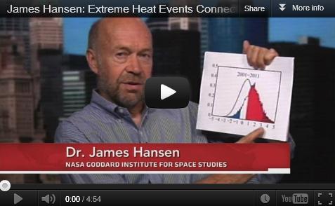
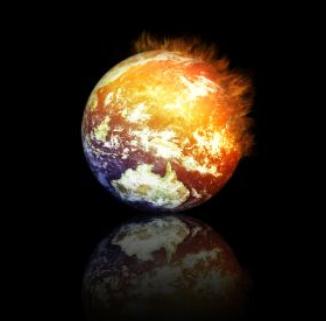
NASA Scientist Links Climate Change, Extreme Weather. CNN has the story; here's an excerpt: "
What
do the 2010 heat wave in Russia, last year's Texas drought, and the
2003 heat wave in Europe have in common? All are examples of extreme
weather caused by climate change, according to a new study from NASA
scientist James Hansen. "This is not a climate model or a prediction
but actual observations of weather events and temperatures that have
happened," he wrote in a Washington Post opinion piece
meant to accompany the study. "Our analysis shows that it is no longer
enough to say that global warming will increase the likelihood of
extreme weather and to repeat the caveat that no individual weather
event can be directly linked to climate change. To the contrary, our
analysis shows that, for the extreme hot weather of the recent past,
there is virtually no explanation other than climate change." The
study, which was published by the Proceedings of the National Academy
of Sciences, looks at the past six decades of global temperatures and
finds what Hansen described as a "stunning" rise in the frequency of
extremely hot summers."
Hansen On The New Math Of Climate Extremes. (PBS video) from
Climate Denial Crock Of The Week: "
PBS Newshour interviews James Hansen on the increasing likelihood of extreme events under climate change."
Study By "Global Warming Godfather": Texas Drought, Europe Heatwaves Are Climate Change.
Some breaking news from NASA's James Hansen, one of the first
scientists to raise awareness of global temperature trends in the
mid-80s, courtesy of
The Washington Post: "
The
relentless, weather-gone-crazy type of heat that has blistered the
United States and other parts of the world in recent years is so rare
that it can’t be anything but man-made global warming, says a new
statistical analysis from a top government scientist. The research by a
man often called the “godfather of global warming” says that the
likelihood of such temperatures occurring from the 1950s through the
1980s was rarer than 1 in 300. Now, the odds are closer to 1 in 10,
according to the study by NASA scientist James Hansen. He says that
statistically what’s happening is not random or normal, but pure and
simple climate change."
Photo credit: AP
* "Public Perception of Climate Change and the New Climate Dice" paper (pdf) is
here, courtesy of Cornell University Library.
Climate Change Is Here - And Worse Than We Thought. James Hansen attempts to connect the climate and (extreme) weather dots in this excerpt of a
Washington Post Op-Ed: "...
To
the contrary, our analysis shows that, for the extreme hot weather of
the recent past, there is virtually no explanation other than climate
change. The deadly European heat wave of 2003, the fiery Russian heat wave of 2010 and catastrophic droughts in Texas and Oklahoma
last year can each be attributed to climate change. And once the data
are gathered in a few weeks’ time, it’s likely that the same will be
true for the extremely hot summer
the United States is suffering through right now. These weather events
are not simply an example of what climate change could bring. They are
caused by climate change. The odds that natural variability created
these extremes are minuscule, vanishingly small. To count on those odds
would be like quitting your job and playing the lottery every morning
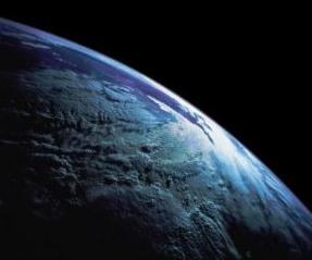
to pay the bills." (Image above: NASA).
Presidential Contenders Can't Duck Climate Change - But They Are. An excerpt from
current.com: "
How
much more proof do we need? Few scientists doubt that Earth's climate
is changing and growing warmer. Only a small number of skeptics dispute
that humans are a prime cause of the problem. But still, as a nation,
we dither. The United States is among the world's top three emitters of
carbon dioxide and other greenhouse gases, along with China and India.
And yet our so-called leaders continue to tiptoe around the issue as if
they might wake a sleeping baby. At least some people are awakening.
They've slept late, but they're awakening nonetheless."
Study Shows Planet Keeping Pace With CO2 Emissions.
The big question: when will the oceans be unable to soak up some of the
excess CO2 floating overhead? Great question. Here's a snippet from
Climate Central: "
Climate
change is a serious enough problem, but it could be a lot worse. About
half of the carbon dioxide we’ve pumped into the atmosphere by burning
fossil fuels has been absorbed by plants and oceans, rather than
staying in circulation to drive up temperatures. Scientists are
convinced this can’t go on forever — but a new study in Nature
shows that we haven’t come to the danger point yet. Over the past 50
years, says the report, humans have quadrupled our emissions, but the
planet has kept up by doubling the amount of CO2 it absorbed. That comes
as something as a surprise: several earlier, small-scale studies have
suggested we might be on the verge of a tipping point where the planet
can’t absorb any more carbon dioxide. “So we decided to take a step
back and ask, ‘do we see this at a global scale?’” said Ashley Ballantyne of the University of Colorado and lead author of the new report, in an interview, “and the answer is no.”
Climate Science Still Trumps Skeptics. Good for Climate Central's Michael Lemonick for debunking many of the regurgitated claims of skeptics in this
L.A. Times article; here's an excerpt: "...
Also
quite predictably, several of the comments repeated critiques of
mainstream climate science that have been raised and thoroughly
debunked literally hundreds of times. Here’s a sampling, along with my
responses:
"theblooms" writes: "Anthropogenic Global Warming is FAR FROM
PROVEN. If the evidence is so damn clear-cut, then why did the East
Anglia University Climate Research Unit cook the books and falsify the
data?"
Response: The East Anglia researchers didn’t
cook the books. Any suggestions otherwise are based on taking fragments
of emails completely out of context. Several investigations have
cleared these researchers of any scientific misconduct whatsoever. The
were reprimanded only for failing to respond with enough thoroughness
to a barrage of freedom-of-information requests from climate skeptics."
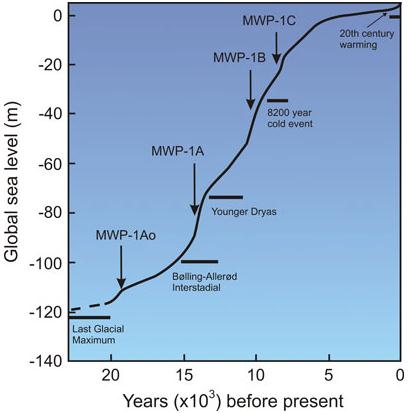
The Great Ice Meltdown And Rising Seas - Lessons For Tomorrow. Here's an excerpt of an interesting paper from
NASA:
"As accumulating atmospheric greenhouse gases lead to further climate
warming, sea level rise will accelerate, endangering coastal communities
by more frequent flooding, exacerbated beach erosion, and saltwater
penetration into streams and aquifers. Twentieth century global sea
level rise has averaged 1.7 mm/yr, increasing to around 3 mm/yr since
1993, as measured by TOPEX/Poseidon and Jason satellite altimetry.
Current trends exceed those of the last few millennia by 1 to 2 mm/yr, based on saltmarsh data from many localities."
Graphic credit above: "
Generalized sea level rise since
the last ice age showing several meltwater pulses (MWP). MWP-1A0, c.
19,600-18,800 years ago; MWP-1A, 14,600 to 13,800 years ago; MWP-1B,
11,000-8,800 years ago; and MWP-1C, ~8,200-7,600 years ago."
Climate Change Is Real - Just Ask My Cows. Here's an excerpt of an Op-Ed from
coshoctontribune.com: "...
In
our part of the country, rain has tended in recent years to come in
great spring and fall floods -- six-to 12-inch deluges bookending
hotter, drier summers. Pretty much nobody whose livelihood depends upon
the weather denies it: The climate hereabouts is changing, mostly for
the worse. The underlying fear, of course, is that the scientists are
right: that what we're experiencing is the knife-edge of worldwide
global warming. People don't much talk about that aspect of it, because
the whole thing's gotten bound up with politics, and rural people tend
to avoid issues with ideological and theological overtones. Farm
Bureau and Cattleman's Association publications tend to be filled with
strident climate change denial, and regional newspapers with
predictable right-wing boilerplate."


No comments:
Post a Comment