82 F. average high for August 6.
88 F. high on August 6, 2011.
69 minutes of daylight lost since June 20 in the Twin Cities.
1 day at or above 90 over the next week (next Tuesday).

Ernesto. As of late Monday night "Ernesto" was still a tropical storm with sustained 65 mph. winds, tracking west, toward Mexico's Yucatan Peninsula and the nation of Belize. It still looks like Ernesto will stay well south of the USA.

More Frequent Intrusions Of Canadian Air. We'll see more hot air - count on it, but looking out into next week I see more frequent and intense pushes of Canadian air south of the border. One such clipper-like system over southern Alberta last night will push showers and T-storms across Minnesota Wednesday, followed by 70-degree air Thursday and Friday.
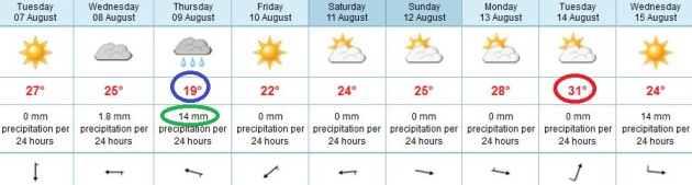
Roller-Coaster Ride. The ECMWF predicts Thursday will be the wettest (and coolest) day of the week, highs may hold close to 70. Under a partly sunny (dry) sky temperatures mellow over the weekend, the European simulation hinting at 90+ by Tuesday of next week, before cooling off again the middle of next week. No sustained 90s in sight.
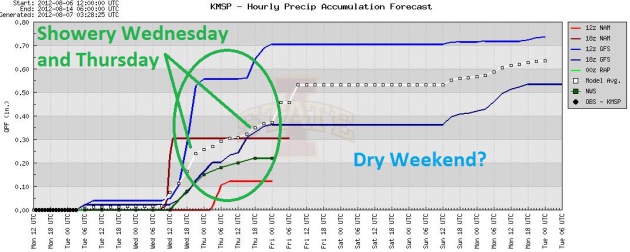
Precipitation Trends. The models show significant divergence in amounts, but timing of the rain showers is fairly consistent: Wednesday and Thursday the two wettest days, followed by a dry weekend. Hey, a guy can hope.

Photo credit above: "In this July 26, 2012 photo, dead fish float in a drying pond near Rock Port, Missouri. Multitudes of fish are dying in the Midwest as the sizzling summer dries up rivers and raises water temperatures in some spots to nearly 100 F." (AP Photo: Nati Harnik).
Photo credit above: "People wade in flash flood waters in Johnson City, Tenn., Sunday Aug. 5, 2012. Heavy rains pounded northeast Tennessee Sunday stranding vehicles and surrounding homes and apartments with flood waters." (AP Photo/The Johnson City Press, Dave Boyd)
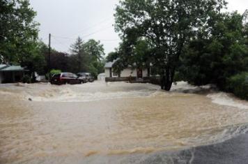
State of Emergency. Tennessee's governor has declared the Johnson City area under a State of Emergency. 3-4" of rain fell in roughly 1 hour, resulting in historic flooding. Photo courtesy of the Johnson City Press.
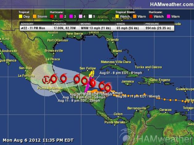
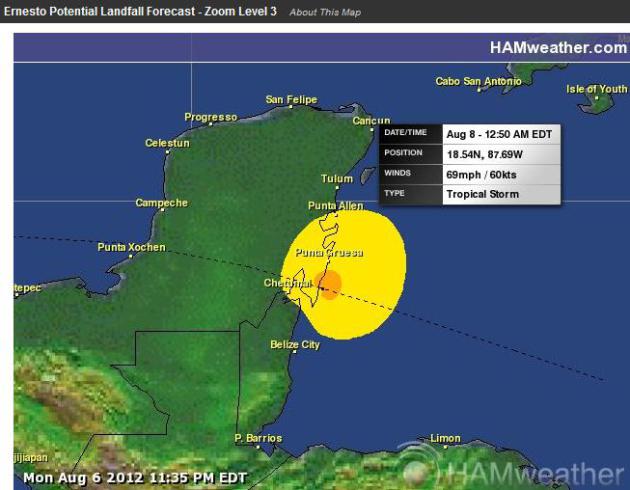
Ernesto Update. Based on NHC data, "Ernesto" will be either a strong tropical storm or a minimal hurricane when it comes ashore late tomorrow night near the border of northern Belize and Mexico, packing sustained winds near 70 mph. The storm should remain well south of Texas, impacting primarily Mexico (twice). Maps above courtesy of Ham Weather.
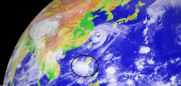
Torrential Rains Paralyze Philippine Capital. Details from Huffington Post: "Torrential rains pounding the Philippine capital on Tuesday paralyzed traffic as waist-deep floods triggered evacuations of tens of thousands of residents and the government suspended work in offices and schools. Incessant downpours set off by the seasonal monsoon overflowed major dams and rivers in Manila and nine surrounding provinces and put authorities on alert. The death toll from last week's Typhoon Saola, which battered Manila and the northern Philippines for several days, has climbed steadily to 51. The head of the government's rescue agency, Benito Ramos, said there were no immediate reports of new casualties early Tuesday after the rains pounded already saturated Manila for more than 24 hours."
Image above: Digital-Typhoon.
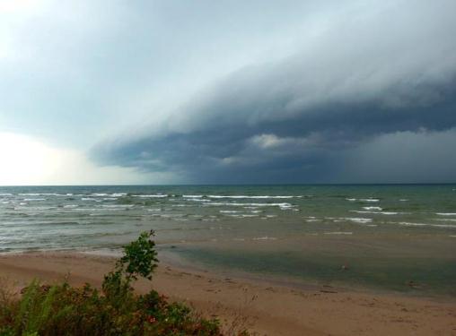
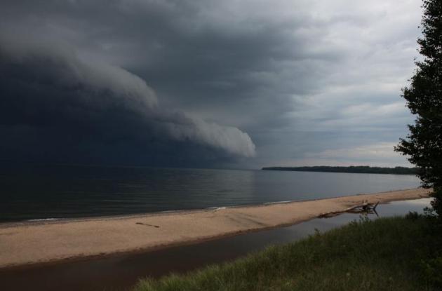
Photo Of The Day: Shelf Cloud. Thanks to Andrea Creighton for capturing a terrific shelf cloud rolling toward Southwick Beach, New York.

Image credit above: NASA.

Photo credit above: "A screenshot from a video by Japanese site Macotakara purporting to show the upcoming iPhone." (YouTube: Macotakara)


In Search Of Real Weatherpeople. No, you can't make this stuff up. Belinda, Dave, Chris - I feel a meteorological cage-match coming on. More details via Facebook:
"THE PRODUCERS OF BRAVO’S “MILLION DOLLAR LISTING” ARE NOW CASTING FOR REAL WEATHERMEN & WEATHERWOMEN FOR A NEW DOCU-SERIES FOLLOWING THE LIFE AND CAREER OF A GROUP OF COMPETITIVE ON AIR WEATHER STARS. WE WANT TO KNOW WHAT HAPPENS ON AND OFF THE AIR. WHAT DOES IT TAKE TO BE THE BEST IN YOUR MARKET? IF YOU ARE A TOP WEATHERMAN IN YOUR CITY OR TOWN AND WOULD LIKE TO BE CONSIDERED, SHOOT AN EMAIL TO:
WEINGRADCASTING@GMAIL.COM
Include all contact info, your reel, and photos. Thank you!"
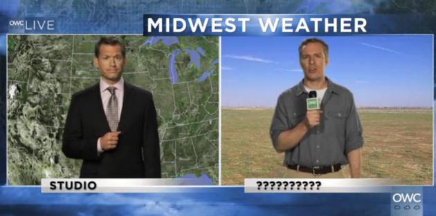
Onion Weather Center: "Extreme Storms To Rip Through God-forsaken Midwestern Wasteland". Breaking news (and a very funny weather clip) from The Onion: "The Onion Weather Center focuses on the Midwest, where a storm system should recede into the distance like any hope of a stable economic future; a tornado bears down on a podunk, backwater hick town; and field reporter Matt Jennings is live from God knows where."
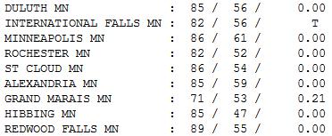
Above-Average Monday. No, the mercury never quite made it up to 90 (we started out a few degrees cooler than I had expected, making it tougher to reach the 90 F. mark). 47 F. Monday morning up at Hibbing, recovering nearly 40 degrees to reach 85. Elsewhere highs ranged from 71 at Grand Marais to 86 St. Cloud and the Twin Cities, 89 at Redwood Falls.
Paul's Conservation Minnesota Outlook for the Twin Cities:
TODAY: Partly sunny, a quiet day. Dew point: 55. Winds: N 10-15. High: 85
TUESDAY NIGHT: Partly cloudy and mild. Low: 64
WEDNESDAY: Free lawn-watering. T-storms likely. Dew point: 61. High: 79
THURSDAY: Showers linger, cool breeze under a mostly cloudy sky. Low: 63. High: 73
FRIDAY: More sun, dry day. Dew point: 57. Low: 58. High: 75
SATURDAY: Intervals of sun, not bad (T-showers may brush far western MN). Low: 61. High: near 79
SUNDAY: Partly sunny, probably dry, a couuple degrees milder. Low: 62. High: 81
MONDAY: Hazy sun, warm & sticky again. Low: 66. High: 88
* Temperatures may hit 90 next Tuesday before cooling off again the latter half of next week.

Favorite Weather Apps?
There's a revolution going on in weather. The
old model: wait for the information to reach you, on radio or TV. Now,
with web sites and apps, everyone really is an armchair meteorologist -
armed with the very latest maps at their fingertips, on their schedule,
for their neighborhoods.
"I don't want a statewide overview, I want weather for my house!" I get it.
If you want another level of safety
download a few apps for your smart phone. My two favorites: My-Cast
Weather Radar (my old company) and RadarScope.
And no, I don't make a penny off either app, but
right now they're the best in the industry - and they may just keep you
out of trouble the next time 70-mph straight-line winds invade your
back yard bash.
We cool off a bit today, a stronger push of
cool, Canadian air ignites more T-storms Wednesday; puddles linger into
Thursday. A fleeting bubble of high pressure treats us to a fine Friday,
and most of the T-showers stay west of town into next weekend. No more
beastly-heat in sight looking out 10 days.
Hurricane Ernesto roughs up Mexico's Yucatan Peninsula today, tracking well south of the USA.
Climate Stories....

Extreme Summer Heat Linked To Climate Change, Scientists Say. Here's an excerpt from The Los Angeles Times: "...The researchers showed the chances of temperatures spiking past their normal variability are much greater now than during the base period. “They found that prior to the onset of human-caused global warming, there were very few of these [anomalous] events,” said John Abraham, professor of thermal sciences at the University of St. Thomas in St. Paul, Minn., and co-founder of the Climate Science Rapid Response Team, an information clearinghouse. “However, with each decade, the number of these very rare events has increased significantly. Not only have the average temperatures increased around the world but so too has the variability. Hansen and his team also showed that while all extreme “hot events” have increased globally, “the occurrence of cold events has virtually disappeared,” Abraham wrote."
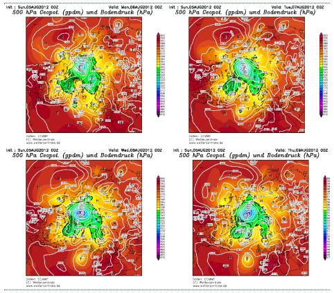
Cyclone Warning! I had to do a double-take on this one. Meteorologists are tracking an unusually vast (and intense) cyclone over the Arctic Circle, unusually deep for early August. One theory: a record amount of melting may be adding additional flux into the atmosphere, fueling and deepening this almost October-like storm raging over the top of the world. Who cares? High winds generated by this super-storm may accelerate the break up of Arctic ice, with unknown effects. We are truly in uncharted waters, as described in the Arctic Sea Ice Blog; here's an excerpt: "I have postponed this post until I was sure that what follows is going to happen. Remember the term 'flash melting'? That's when from one day to the next large swathes of ice disappear on the University of Bremen sea ice concentration maps. We witnessed one such instance last year when a relatively large and intense low-pressure area moved in from Alaska over the ice in the Beaufort and Chukchi Sea regions (see blog post). It lasted about a day or two and then quickly faded, but the effects were spectacular. Well, it looks like we have something bigger coming up this year. This is the ECMWF weather forecast for the coming four days (click for a bigger version)."
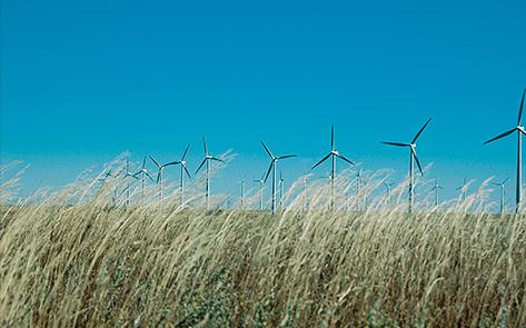
Photo credit above: "Xcel's Ponnequin Wind Farm on the Colorado-Wyoming border. The wind farm helped the utiltiy produce 57% of its power from wind one night this spring - a U.S. record." Picture: Steve Berry.


No comments:
Post a Comment