80 F. high yesterday in the Twin Cities.
82 F. average high for August 8.
82 F. high on August 8, 2011.
.01" rain fell on KMSP yesterday (strong to severe storms bubbled up over southeastern Minnesota around the dinner hour).
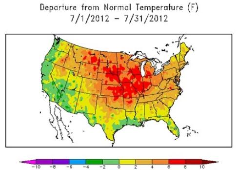
July 2012: Hottest Month In U.S. History. Accurate
weather records go back to the late 1800s. Since then there has never
been a month as hot as July, 2012. Details from NOAA: "According to NOAA
scientists, the average temperature for the contiguous U.S. during July
was 77.6 F, 3.3 F above the 20th century average, marking the hottest
July and hottest month on record for the nation. The previous warmest
July for the nation was July 1936, when the average U.S. temperature was
77.4 F. The warmest July temperatures contributed to a record-warm
first 7 months of the year, and the warmest 12-month period the nation
has experienced since record-keeping began in 1895. Just looking at the
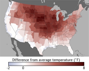
map I was struck with the thought that this gives new meaning to "red
states".
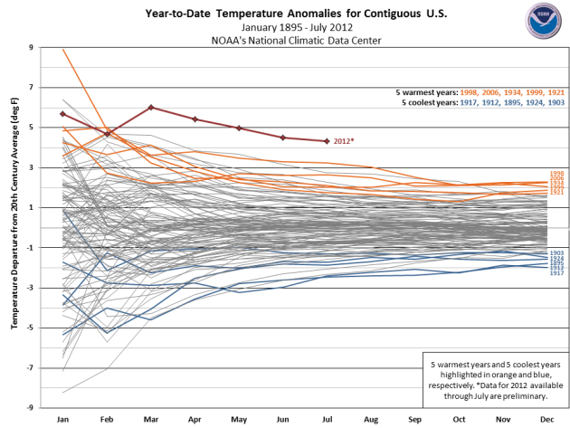
Wake-Up Call. More like a smack upside the head. You can't look at this graph and not, on some level, be a little troubled. According to
NOAA NCDC
2012 is running 4-6 F. above average, nationwide, blowing away the
previous hot weather records: 1998, 2006, 1934, 1999 and 1921.
U.S. Has Hottest Month On Record. More perspective on an historic July from meteorologist Jason Samenow, at The Washington Post's
Capital Weather Gang: "
In
118 years of U.S. records, July 2012 stands as king, hotter than any
month previously observed. NOAA reports today that the average
temperature across the continental U.S. was 3.3 degrees Fahrenheit
warmer than the 20th century average, 0.2 degrees hotter than the
previous record set in July, 1936. Not only was the month of July
unrivaled for its hot temperatures across the nation, but so too were
the first seven months of the calendar year and the last 12 months. In
fact, the last four 12-month periods have each successively established new records for the warmest period of that length."
Map credit above: "
Temperatures compared to normal in July across the Lower 48 states (Regional Climate Centers)."
State Of The Climate.
NOAA NCDC has more details on our record-shattering summer:
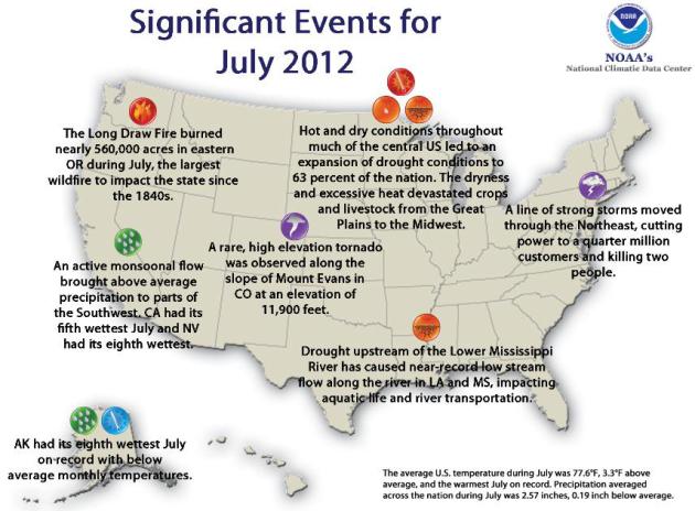
- According to the July 31, 2012, U.S. Drought Monitor (USDM),
62.9 percent of the contiguous U.S. was experiencing moderate to
exceptional drought at the end of July. This is an increase of about
6.9 percent compared to the end of June. The maximum value of 63.9
percent reached on July 24 is a record in the 13-year history of the
USDM.
- The area of the country in the worst drought categories (extreme
to exceptional drought) doubled from 10 percent last month to 22
percent this month. The extreme dryness and excessive heat devastated
crops and livestock from the Great Plains to Midwest.
Ouch! July In U.S. Was Hottest Ever In History Books. Here's more information from a story at
Bloomberg Businessweek:
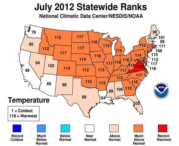
"...Three of the nation's five hottest months on record have been
recent Julys: This year, 2011 and 2006. Julys in 1936 and 1934 round
out the top five. Last month also was 3.3 degrees warmer than the 20th
century average for July. Thirty-two states had months that were among
their 10 warmest Julys, but only one, Virginia, had the hottest July on
record. Crouch said that's a bit unusual, but that it shows the
breadth of the heat and associated drought."
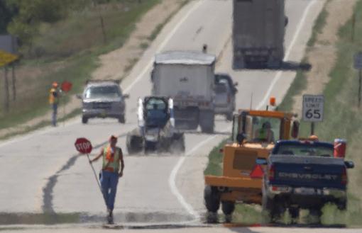
Photo credit above: "
Heat waves rise while a Kansas
Department of Transportation road crew works on a section of US 59 near
Nortonville, Kan., Monday, Aug. 6, 2012." (AP Photo/Orlin Wagner)
3rd Hottest July On Record In Minnesota. Virginia has the warmest July on record, across the Upper Midwest ever state was in the top 5 warmest Julys on record. Map:
NOAA NCDC.
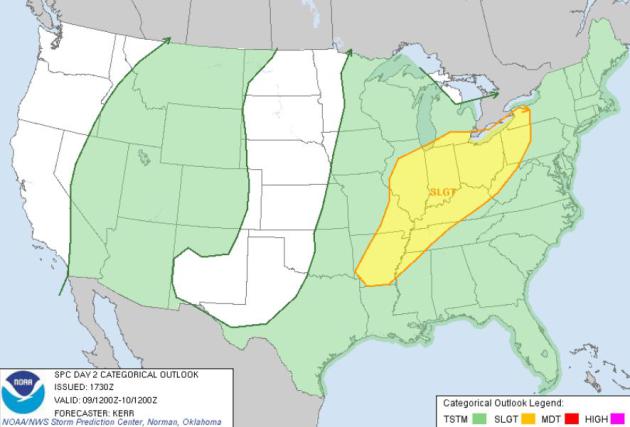
Thursday Severe Risk. SPC shows an elevated risk of
hail and damaging straight-line winds from Chicago and St. Louis east to
Detroit, Louisville and Pittsburgh, as an upper level low irritates a
stalled frontal boundary over the Ohio River Valley.
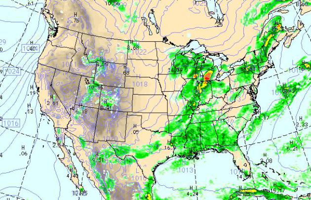
Today's Weather Map. The WRF model (valid 4 pm
today) shows light to moderate showers over the Upper Midwest, strong to
severe T-storms over the Great Lakes and Ohio Valley, more spotty
T-storms over the Mid South and Lower Mississippi Valley. West of the
Mississippi: precious little rain
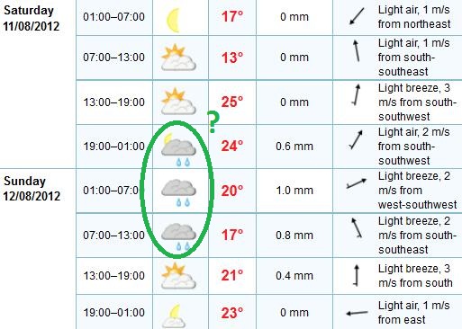
Weekend Preview. The ECMWF model shows a ripe
environment for a few widely scattered showers and T-showers Saturday
night into Sunday morning. At this point Saturday looks like the nicer
day with more sun, upper 70s to near 80. Sunday should be more humid,
the best chance of a little sun afternoon hours.
More Hints Of Autumn. Today and Friday look very
comfortable, highs in the mid 70s today, upper 70s tomorrow with low
humidity. We heat up next week - 90+ possible by Wednesday, but any
discomfort will be brief. A vigorous cold front arrives the middle of
next week;
by next Friday highs may hold in the 60s over most of Minnesota!
Weather? Climate Change? Why The Drought Is Persistent And Growing. Yes, a dying La Nina may have contributed to the drought, one of many factors, according to this story at
The Christian Science Monitor; here's an excerpt: "
Several
factors have contributed to the expanded drought, meteorologists say.
The lingering aftereffects of two years' worth of colder-than-normal
sea-surface temperatures in the eastern tropical Pacific – a condition
known as La Niña – set the stage. La Niña events drive average storm
tracks farther north than usual as they snake across North America. And La Niña tends to stifle hurricane formation in the Atlantic and Caribbean.
Both contributed to a drier southern tier. But for some parts of the
United States, some researchers add, the dryness encouraged by this
natural climate cycle appears to be reinforcing a longer-term drying
that is consistent with climate models gauging the effects of global
warming. For the West in particular, conditions may be setting up for
what researchers call a “megadrought” by the end of the century."
Photo credit above: "
A damaged corn crop in Rice County, in central Kansas, August 7." Jeff Tuttle/Reuters
The Silver Lining In The Drought. Here's an excerpt of an Op-Ed in
The New York Times: "
FROM
where I sit on the north end of America’s grain belt, I can almost
hear the corn popping to the south of me. The drought threatens to drive
up global corn prices beyond their level in 2007-8, when food
demonstrations broke out around the world. But such crises often lead to
change — and transformation is what is needed to make our food system
less vulnerable. We have become dangerously focused on
corn in the Midwest (and soybeans, with which it is cultivated in
rotation). This limited diversity of crops restricts our diets,
degrades our soils and increases our vulnerability to droughts."
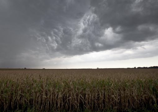
Photo credit above: "
Dark clouds from a passing thunder
storm hang over a dry cornfield in Blair, Neb., Wednesday, Aug. 8,
2012. The area received some rain from the storm. Farmers in the
nation's Corn Belt are confronting a drought that stretches from Ohio
west to California and from Texas north to the Dakotas. Only in the
1930s and the 1950s has a drought covered more of the U.S., according to
the National Climatic Data Center in Asheville, N.C." (AP Photo/Nati Harnik)
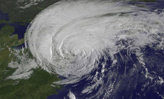
Hurricanes, Typhoons And Cyclones: Storms Of Many Names. Yes, they are different names for the same warm-core storms that form over warm ocean water, worldwide.
Live Science has a good explanation; here's an excerpt: "
There has to be a perfect storm, so to speak, of conditions for a hurricane to form, including:
- Water that is at least 80 degrees F (26.6 C)
- Relatively moist air
- Very warm surface temperatures
- A continuous evaporation and condensation cycle
- Wind patterns of varying directions that collide (converging winds)
- A difference in air pressure between the surface and high altitude
Tropical cyclones form all around the world, generally about
300 miles (480 kilometers) north or south of the equator. When they
form in the Atlantic or Eastern Pacific, the storms are called
hurricanes. They are called typhoons in the western North Pacific and
cyclones in the South Pacific and Indian Ocean. [Infographic: How, When & Where Hurricanes Form]"
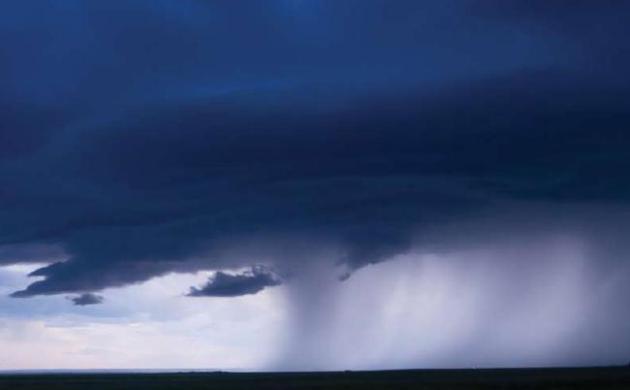
 Shelf Cloud
.
A tip-off to potentially severe winds, beware of T-storms with a
protruding "lip". Thanks to A.J. Lane, who snapped this photo near Ames,
Iowa Wednesday.
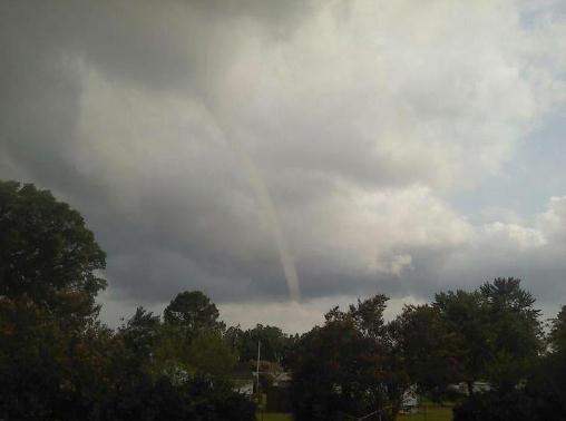
Tornadoes In Unusual Places. Thanks to John Andrew Bordash for sharing this photo; details: "
This
tornado was near Hallowing Point, MD yesterday around 6:00PM. It
started as a waterspout over the Patuxent River then moved on land in
Calvert County. The NWS in Sterling, VA issued a Tornado Warning. The
storm was slow mover but quickly dissipated."
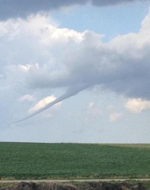
From Drought To Tornado. Thanks to Virginia Semerad
and the Omaha, Nebraska office of the National Weather Service for
sharing this. It looks strange to see a tornado hovering over fried
fields.
Not A Honda In Sight. I'm glad the weather is
cooperating with bikers gathered at Sturgis, South Dakota. Thanks to
Willy Bondling for passing this one along.
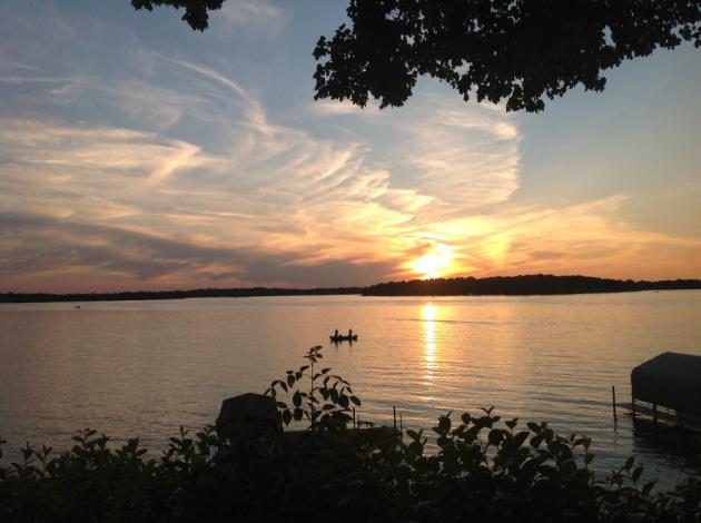
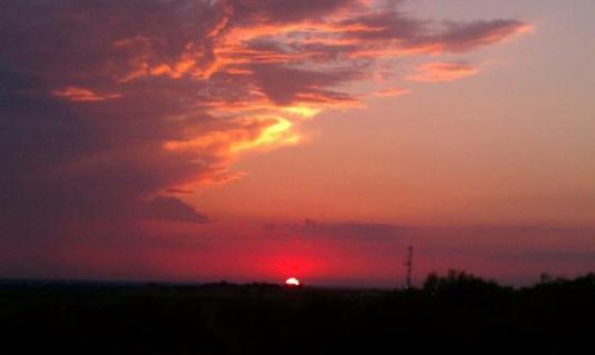 One Fine Sunset
. From WeatherNation TV's
Facebook Site: "
This photo by @JonRHansen knocked the socks right off my feet. Sunset Wednesday night in Rhome, TX."
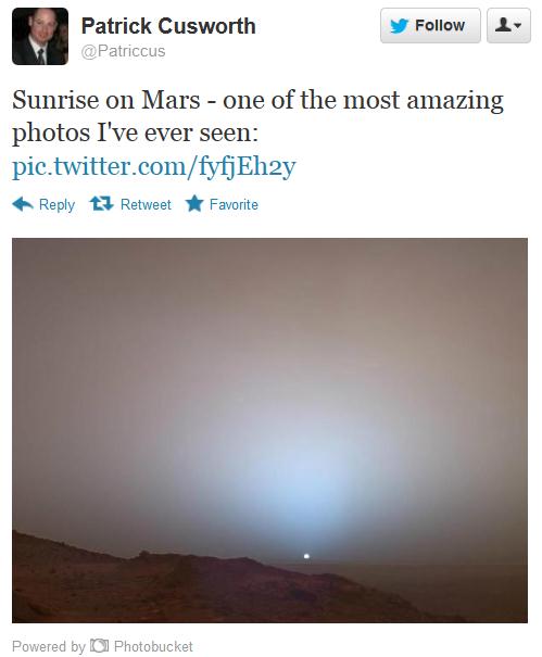 Martian Sunrise
. Thanks to NASA, Patrick Cusworth, and
Twitter for this one-of-a-kind shot.
You Too Can Own A $8700 Corn Cob House. Now I've officially seen everything - details from
gizmag.com: "
French
architectural firm St. André-Lang has designed and built a compact
circular housing prototype that incorporates corn cobs within the
walls. The 20 square meter (215 square foot) pavilion style home is
located in the protected parklands of Muttersholtz, France and recently
won the Archi<20 and="and" andr="andr" ang="ang" architect="architect" architecture.="architecture." around="around" bastien="bastien" be="be" carpenter="carpenter" co-creator="co-creator" competition="competition" cost="cost" em="em" environmentally-friendly="environmentally-friendly" for="for" gizmag.="gizmag." had="had" he="he" low-cost="low-cost" of="of" partners="partners" project="project" real="real" saint-andr="saint-andr" some="some" st.="st." the="the" told="told" total="total" ut="ut" was="was" we="we" woodworker="woodworker" would="would">.”
Beware, Tech Abandoners. People Without Facebook
Accounts Are "Suspicious". Confirming one of my darker fears, yes, now
you need FB just to be "credible" with a future boss. The eStress is
building. Details from
Forbes.com; here's an excerpt: "
The
term “Crackberry” seems silly today — and not just because consumers
OD’ed on Blackberry and moved on to iDealers. The term arose in an
earlier “aughts” time when Blackberry dominated the smartphone market
and lawyers and execs were nearly the only ones who had them, due to
their need to be able to respond to email immediately. Things have
changed. Now we all need to be able to respond to email immediately. And
to tweet. And to instantly share our photos on Facebook.
We’re all addicted to technology now, and not just to the Blackberry.
We’re “addicted” to our iPhones, and Facebook, and Twitter, and
Android, and Pinterest, and iPads, and Word with Friends, and
fill-in-the-blank-with-your-digital-dope-of-choice."
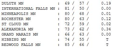
Unsettled. It felt pretty good out there -
temperatures in the 70s most of the day, across most of the state.
Afternoon highs ranged from 69 at Duluth (sweatshirt weather already?)
to 72 St. Cloud, 80 Twin Cities and Rochester, and 85 at Redwood Falls.
Paul's Conservation Minnesota Outlook for the Twin Cities and all of Minnesota:
TODAY: Unsettled, still comfortably cool. Clouds linger, shower late? Winds: N 10+ High: 75
THURSDAY NIGHT: Evening shower, then slow clearing, cool breeze. Low: 56
FRIDAY: More sun, beautiful. Dew point: 52. Winds: E 7-12. High: 76
SATURDAY: Plenty of sun, probably the nicer day for outdoor plans. Dew point: 50. Winds: NW 8-13. Low: 57. High: 79
SATURDAY NIGHT: More clouds, chance of a T-storm late. Low: 61
SUNDAY: Some sun, risk of thunder, slightly more humid. Dew point: 61. Winds: East 8-13. Low: 61. High: 80
MONDAY: Sunny, heating up. Dew point: 66. Low: 64. High: 84
TUESDAY: Sticky and stormy. Dew point: 69. Low: 67. High: near 90
WEDNESDAY: Hot, severe outbreak? Dew point: 71. Low: 69. High: 92
A Whole New Level of Hot
NOAA confirms last month was not only the
warmest July ever recorded, but the hottest month since 1895. The first 7
months: warmest ever, running 4 to 6 F warmer than the
long-term, 20th century historical average.
Yes, we've always had heat waves and drought,
but there's a growing body of peer-reviewed scientific evidence that we
may be turbocharging the heat. If this year doesn't make open-minded
skeptics rethink their position I'm not sure what will.
Maybe someday we'll get past denial and work
together on solutions that don't a). expand government, or b). wreck the
economy. Technology & innovation will power this transformation,
but like any good (carbon) addict, we need to first recognize that we
have a problem.
Don't believe our weather patterns are changing? Talk to a farmer.
A late-day instability shower today gives way to
a comfortable blue sky Friday. The approach of warmer air may set off a
T-storm Saturday night & Sunday.
The craziness continues
next week: 90-94 F. Tuesday & Wednesday, severe storms midweek, then
MUCH cooler. By Friday highs may sink into the 60s!
What an odd summer.
Climate Stories...
Blame Climate Change For Increasingly Extreme Summers, Says Leading Climatologist. Here's a snippet from
Discover Magazine: "...
Researchers
averaged the summer and winter temperatures for multiple locations
across the globe during the years from 1951 to 1980, establishing a
baseline for each season. Then they measured how much the temperature
varied from this average over the years. They found an increasing
number of anomalies in the past 30 years. We no longer have equal odds
of the summer temperatures being unusually hot, or unusually cool.
Instead, as the researchers phrase it, we are dealing with loaded dice:
we are now much more likely to have a hot summer than an average or
cool one. And hot temperatures have become both more frequent and more
intense. In the time period from which the researchers drew their
average, less than one percent of land on Earth suffered from extreme
hotter-than-usual temperatures (more than three standard deviations
above the average) at any one time. Now, these temperature hotspots
cover 10 percent of the land."
Senator Reid: "Stop Acting Like Climate Change Deniers Have A Valid Point Of View - They Don't". Details and a video clip from
The Daily Kos. Here's an excerpt of Sen. Harry Reid's recent comments on climate change: "
The
seriousness of this problem is not lost on your average American. A
large majority of people finally believe climate change is real, and
that it is the cause of extreme weather. Yet despite having
overwhelming evidence and public opinion on our side, deniers still
exist, fueled and funded by dirty energy profits. These people aren't
just on the other side of this debate. They're on the other side of
reality. It's time for us all – whether we're leaders in Washington,
members of the media, scientists, academics, environmentalists or
utility industry executives – to stop acting like those who ignore the
crisis or deny it exists entirely have a valid point of view. They don't."
Another View: Global Warming Alarm Too Costly To Let Continue. How do we stop shouting at each other and reach a pragmatic way forward? Here's a snippet of an intriguing Op-Ed at
The Des Moines Register that caught my eye: "..
But,
the polarization in today’s global warming debate — alarmist versus
skeptic, conservative versus liberal, capitalist versus socialist — has
become so severe that the struggle will drag on for many years more
unless a radically different approach is taken. New findings from the
Cultural Cognition Project at Yale University Law School point the way.
They found that, when faced with having to support one side or the
other in science debates, most people are influenced far more by their
cultural and social worldviews than by the actual data. Citizens will
usually agree with the side that comes closest to the values of the
“tribe” they most identify with. In many cases, the facts don’t matter
at all."
Climate Change: What Will It Take To Wake Up The World? Here's an excerpt of an Op-Ed from Rep. Carolyn Maloney at
The Hill's Congress Blog: "
....Short
of world or national action, there are small signs of hope. More than
500 American cities and towns have already pledged to meet the Kyoto
Protocol’s targets for greenhouse gas emissions reductions. The hope,
though, remains that the voices of young people will make a difference.
In many ways, there is a limit to what we can do to help today’s
children. Carbon dioxide can stay in the atmosphere for nearly a
century, so Earth will continue to warm in the coming decades. Experts
say that the climate we are used to is no longer a reliable guide for
what to expect in the future. We hear a lot about the debt we are
creating for our grandchildren and great grandchildren. Yes, financial
worries are important. But all the money in the world won’t mean a
thing if future generations can’t be productive on the Earth we leave
them."
U.S. Criticized On Global Warming Stance. Details from
UPI: "
BRUSSELS, Aug. 7 (UPI) -- The
United States has come under criticism for suggesting the target of
keeping global warming below 2 degrees Celsius should be removed from
climate talks. At a 2010 U.N. climate convention governments had agreed
to take "urgent action" to meet the target but chief U.S. climate
negotiator Todd Stern recently said insisting on the target would lead
to "deadlock." Now the European Union and the Alliance of Small Island
States have responded by saying the Unites States should stick to
promises made. "Suddenly abandoning our agreement to keep global warming
below 2C is to give up the fight against climate change before it even
begins," said Tony de Brum, minister in Assistance for the Marshall
Islands."









No comments:
Post a Comment