88 F. high temperature in the Twin Cities Tuesday.
82 F. average high for August 7.
82 F. high temperature on August 7, 2011.
45 F. record low for August 7 (1972).
.09" rain predicted for MSP from later today thru Thursday evening (00z NAM model).
90s.... And 60s Next Week? The extended outlook
(ECMWF) shows a cooling trend into Thursday (the wettest day), a slow
warming trend over the weekend with highs near 90 by Monday and Tuesday.
A vigorous cool front arrives the middle of next week; by next Thursday
highs may be in the 60s (!) Good grief.
"
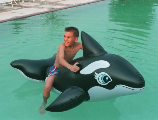
Finally, if you invested in an expensive swimming pool, wait
until the summer to sell: a home with a swimming pool will sell for
$1,600 more, on average, in the summer versus the winter." - from a mainstreet.com story below on the influence of day-to-day weather on our spending habits.
"There is a roughly 12 percent chance of a
major solar storm every decade, making them a one-in-a-hundred-year
event. The last major one was over 150 years ago." -
excerpt from a Reuters story below; the solar cycle peaks in 2013, with
an elevated risk of a major solar storm, one capable of disrupting
satellite communications, even the power grid.
"
The percentage of the earth’s land surface covered by extreme
heat in the summer has soared in recent decades, from less than 1
percent in the years before 1980 to as much as 13 percent in recent
years, according to a new scientific paper." - from a New York Times article; details below.
"...
The second proposition will be uncomfortable for supporters
of climate action, but it is also true: Some proposed climate
solutions, if not well designed or thoughtfully implemented, could
damage the economy and stifle short-term growth. As much as
environmentalists feel a justifiable urgency to solve this problem, we
cannot ignore the economic impact of any proposed action, especially on
those at the bottom of the pyramid. For any policy to succeed, it must
work with the market, not against it." - from a Tuesday Wall Street Journal opinion piece; details below.
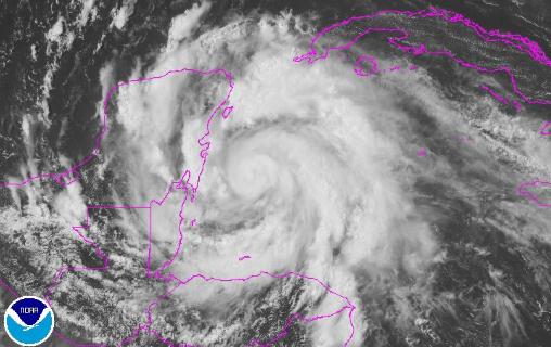
Hurricane Ernesto. Tuesday evening Ernesto
strengthened into a minimal, Category 1 hurricane, pushing due west
toward Belize and Mexico's Yucatan Peninsula. Details from NOAA via
FB: "
Hurricane
Ernesto closing in on the Yucatan area of Mexico. Expected to cross
into the Bay of Campeche and continue into Mexico. Right now, a
category one hurricane with sustained maximum wind of 80 mph."
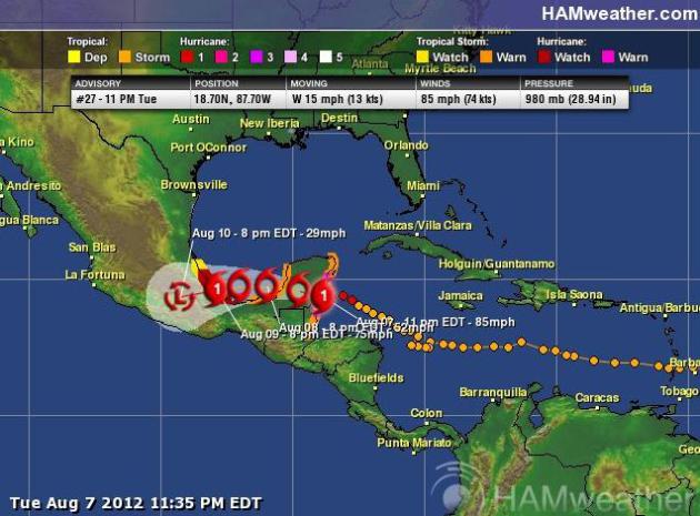
Double-Whammy. Mexico will be struck twice by
Ernesto, on the Yucatan Peninsula (overnight), again after it emerges
over the Gulf of Campeche late Thursday. The only saving grace: the
fetch over warm water won't be long enough for severe strengthening,
both strikes as a Category 1 hurricane. Some 8"+ rainfall amounts are
possible over mountainous terrain inland - the greatest risk: flash
flooding. Map: NHC and Ham Weather. Things are getting a little more
interesting in the mid-Atlantic; meteorologists tracking two more areas
of disturbed weather. The latest from NHC
here.
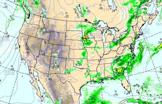
Today's Weather Map. The WRF model (valid 1 pm
central time today) shows welcome showers and possible thunder over much
of the Midwest, an eastbound cool front sparking T-showers from
Cleveland to Rochester, more tropical downpours from the Carolinas into
the panhandle of Florida. Precious little rain is forecast from the
Plains to the west coast.
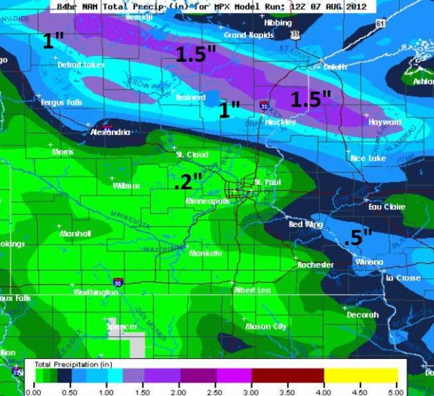
Significant Rain Up North. The 00z NAM prints out
some 1-1.5" rainfall amounts from Detroit Lakes and Bemidji east to
Brainerd and the Duluth area, closer to .20" rain for the metro by
Friday morning.
Weekend Preview. I know it's wrong to be daydreaming
about the weekend on a Wednesday, but the news is pretty good, highs in
the upper 70s Saturday, topping 80 by Sunday as winds swing around to
the south. Right now it looks dry - we'll see if this outlook holds up
over time as new model data arrives.
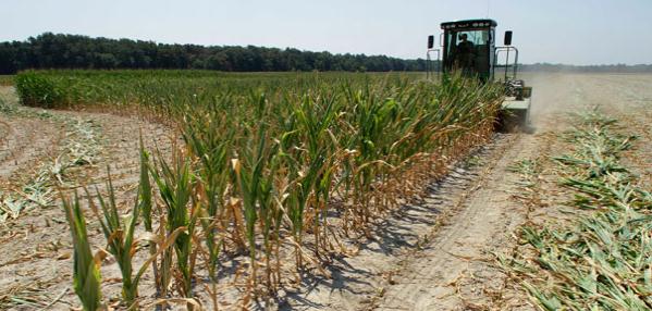
Feeding The World In Face Of Drought. Will the
historic drought gripping 60% of the USA trigger a global spike in food
prices and even famine? Here's an excerpt from Politico: "
Americans
now know that living in the world’s breadbasket — where the most
advanced agricultural technologies have created some of the highest
crop yields — does not necessarily immunize them from the
vulnerabilities of depending on Mother Nature. More than three-quarters
of U.S. corn and soybean crops have now been affected by record
drought — the worst dry spell since the 1950s. The United States is not
the only country feeling the heat. India is experiencing a 22 percent
falloff in vital monsoon rains and Brazil went through its most severe
drought in a half-century."
Photo credit above: "
Corn prices are already up 50 percent from just a month ago, the author writes." | AP Photo
Hottest Year On Record For The Northeast. Even
though the very worst of the heat and drought has settled over the Ohio
Valley, Midwest and Great Plains, the Northeast has seen a remarkably
warm year-to-date, as well. Details from
Science Daily: "
If
you live in the Northeast, welcome to the hottest year on record. New
data released by the Northeast Regional Climate Center at Cornell
University shows the Northeast’s seven-month average (January through
July) of 49.9 degrees was the warmest such period since 1895, the year
such record keeping began. It was the second warmest such period in
Pennsylvania and West Virginia, and the warmest first seven months of
the year in the rest of the Northeast. The 12 months that ended July 31
was likewise the warmest such period in 117 years in the Northeast, and
in all of the states except West Virginia – where the average
temperature of 54.7 degrees missed tying the record set in 1932 by 0.1
degree."
Photo credit above: AP Photo/The Express-Times, Matt Smith.
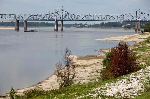
Floods And Drought: Extreme Year For Mississippi River. From one extreme to the next, feast or famine for barge operators on the Mighty Mississippi. Here's a
YouTube clip from AP: "
In
just one year the Mississippi River has experienced record flooding
and near record low water levels due to drought. The AP received rare
access to the U.S. Army Corps of Engineers efforts to dredge and keep
the channels flowing for commerce."
Photo credit above: "
The banks of the Mississippi River
near Vicksburg, Miss., continue to erode as the 2012 drought deepens,
Monday, Aug. 6, 2012. Barges are moving down the largest waterway in
the U.S. with decreased loads and at slower speeds because of the risk
of hitting debris or sand." (AP Photo/Robert Ray)
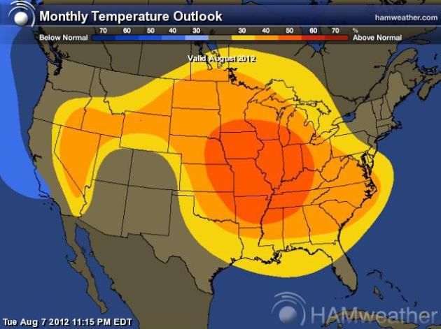
Big Surprise. NOAA CPC is predicting a warm bias for
much of America through the month of August, centered over the Midwest
and Middle Mississippi River Valley. Surprised? Me neither. Map: Climate
Prediction Center and
Ham Weather.
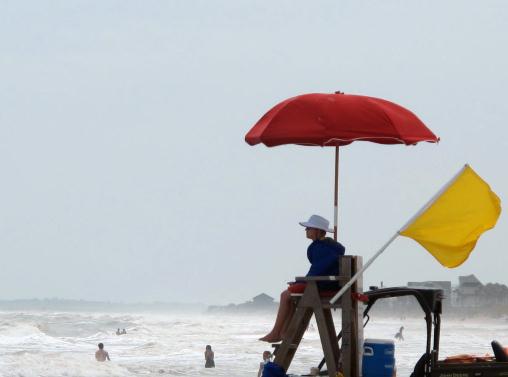
Hurricane Season: Fast, Not Furious. I had no idea. Here's an excerpt from an eye-opening article about the hurricane season, to date, from
floridatoday.com: "
Hurricane
season 2012 might seem like a snoozer, but statistically speaking,
it's been a record-setter: Tropical Storm Debby, which formed June 23,
was the earliest fourth-named storm in history. Another interesting
meteorological tidbit about this season, which runs June 1 through
November 30: two tropical storms (Alberto and Beryl) formed in May,
before the season even started. "The only other time two storms formed
before June 1 was 1887 and 1908, so that's kind of weird," said
National Hurricane Center spokesman Dennis Feltgen. "And Beryl, which
came ashore at Jacksonville Beach, was the strongest pre-June cyclone
ever to make U.S. landfall."
(May 29, 2012 file photo from Folly Beach, South Carolina courtesy of AP Photo/Bruce Smith)
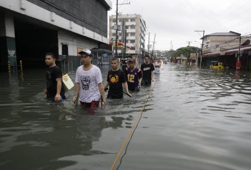
Flooding Brings Chaos To Philippine Capital.
CNN.com has the story; here's an excerpt: "
Fueled
by seasonal monsoon rains and a nearby tropical storm, widespread
flooding in the Philippines worsened Tuesday, causing a landslide that
killed nine members of a family, the national disaster agency reported.
The landslide in the Manila suburb of Quezon City buried two houses,
leaving the nine people dead and four others injured, according to the
National Disaster Risk Reduction and Management Center. Three of the
dead were children, the state-run Philippines News Agency reported. The
capital city of Manila got 504 millimeters (about 20 inches) of rain
Tuesday, PNA reported, with more on the way."
Photo credit above: "
Filipinos wade along a flooded area
in Quezon City, north of Manila, Philippines, Tuesday Aug. 7, 2012.
Relentless rains submerged half of the sprawling Philippine capital,
triggered a landslide that killed eight people and sent emergency crews
scrambling Tuesday to rescue and evacuate tens of thousands of
residents." (AP Photo/Aaron Favila)
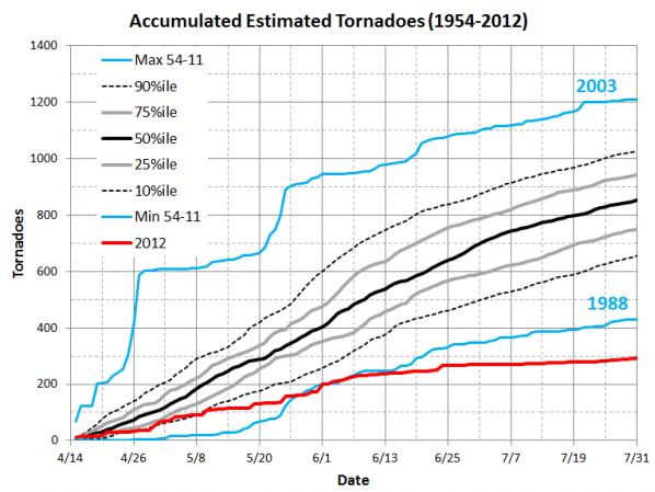
Lull In Tornado Activity April - July 2012 In The U.S.
One of the few silver linings of the drought - when it's this hot and
dry, the main thermal gradient (and resulting wind shear) is pushed way
north. You can't get tornadoes out of a sunny, 110 degree sky. Details
from
EarthSky: "
With
the month of August in full swing, the United States’ tornado season,
which typically peaks from March through July, has officially ended.
This year, there was an active early tornado period during the months of
January through mid-April, with a particularly dramatic day of
tornadoes on April 14, 2012 (over 80 tornadoes across the central United States).
But after mid-April, the tornado count drastically dropped, and this
2012 tornado season became extremely quiet. July 2012 recorded a
preliminary report of only about 24 tornadoes, which is unusually low.
Overall, the 2012 tornado season was the complete opposite of the 2011
season. Meanwhile, Canada has some severe weather and tornadoes. See
the videos at the bottom of this post."
Graphic credit above: "Accumulated number of tornadoes from 15 April-31 July from 1954-2011 with 2012 compared to it." Image Credit: NOAA/Brooks.
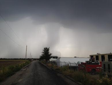
A Microburst That Looks Like A Tornado.
A downburst or microburst is a severe thunderstorm downdraft that
reaches the ground, and spreads out, creating violent straight-line
winds. It can be deadly for aviation, causing a sudden increase (and
decrease) in lift. Here's an excerpt of an interesting post from
meteorology legend
Mike Smith: "
This
morning, we had high-based thunderstorms in the Wichita area and I
took this photo of a microburst that -- to the untrained eye -- would
look like a tornado, complete with a debris cloud near the ground. To my
eye, the giveaway (other than the fact the atmosphere was not
conducive to tornado development) is there was no rotation at all. A
tornado at this distance would have shown clear rotation."
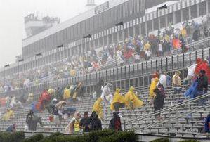
How Weather Issues Have Been Handled In Sports.
There have been numerous high-profile events in recent years impacted by
severe weather, with resulting deaths and injuries. How many of these
losses could have been avoided using better alerting systems, and having
action plans in place to move thousands of fans? Is it even possible to
move that many people before a severe storm strikes? Here's an
interesting story from
RepublicanAmerican: "
INCIDENTS:
A 41-year-old NASCAR fan was struck by lightning and killed Sunday as
he stood near his car in the parking lot of Pocono Raceway in
northeastern Pennsylvania. Nine others were injured during Sunday's
violent storm.
POLICY: NASCAR stays in contact with track officials when weather may
affect a race, but track officials are responsible for communicating to
fans about approaching severe storms. Some fans posted on Pocono
Raceway's Facebook page that they never heard Sunday's weather-related
announcements. Decisions whether to proceed are typically made
minute-by-minute, although there have been instances the last several
years when NASCAR worked with track officials in advance of incoming
weather. This season, the Daytona 500 was postponed for the first time
in its 54-year history because steady rain made a Monday evening start
the safest solution."
Photo credit above: "
Fans leave
the stands after the start of the NASCAR Sprint Cup Series auto race
was postponed due to rain on Sunday, Aug. 5, 2012, at Pocono Raceway in
Long Pond, PA." (AP Photo/Mel Evans)
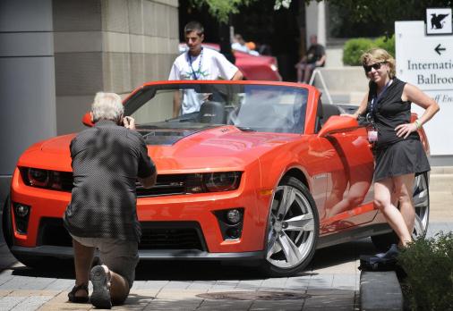
How Weather Influences Life's Big Spending Decisions. I thought this was interesting, how are spending habits are tied to changes in weather.
Mainstreet.com has the story; here's an excerpt: "
For
the sake of argument, let’s say you have a fleet of vehicles and want
to clear some space in your five-car garage. What should you sell
first? The vehicle with the highest mileage or the lowest? The
gas-guzzler or the hybrid? Last year’s model or the classic? How about
the one that fits the weather pattern? It probably doesn’t come as a
surprise that convertibles sell better in the spring than in the dead
of winter, or that small-engine cars move faster when gas prices
spike. Now there's academic research to support and even quantify the
effects weather has on the sales process. Convertibles don't just sell
better in warm weather, specifically, a 20-degree increase in
temperature spurs an 8.5% increase in convertible sales, according
to Jorge Silva-Risso, an associate professor of marketing at the
University of California’s Riverside’s School of Business
Administration."
Photo credit above: AP Photo/The Grand Rapids Press, Chris Clark.
NASA Deploying New Drone Technology To Track Hurricanes. Here's a snippet of a fascinating article/interview from
redorbit.com: "
Scott Braun is the Hurricane Severe Storm Sentinel (HS3)
mission principal investigator and a research meteorologist at NASA’s
Goddard Space Flight Center in Greenbelt, Md. Scott studies hurricanes
from the inside out. HS3 is a five-year mission specifically targeted
to investigate hurricanes in the Atlantic Ocean basin. In his role as
Principal Investigator, Scott leads a diverse team of hurricane and
instrument scientists to design and conduct experiments using NASA’s
two Global Hawk unmanned aircraft to understand better the
meteorological conditions that favor storm formation and often lead to
the development of major hurricanes. The campaign is set to take to the
sky this September from Wallops Island, Va."
Photo credit above: "
This Global Hawk unmanned aircraft
is one of two that are used by NASA for Earth science missions and by
Northrop Grumman for follow-on developmental testing." Credit: NASA/Tony Landis
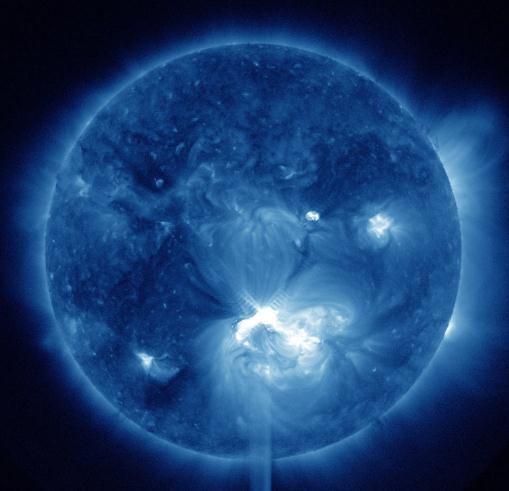
Space Weather And The Coming Storm. Solar activity is forecast to peak in 2013. With any luck the power will stay on. Here's an excerpt from a story at
Reuters: "
The
delicate threads that hold modern life together are dramatically cut
by an unexpected threat from outer space, with disastrous effects. It's the stuff of science fiction usually associated with tales of rogue asteroids on a collision course with earth.
But over the next two years, as the sun reaches a peak in its 10-year
activity cycle, scientists say there is a heightened risk that a
whopping solar storm could knock out the power grids, satellites and
communications on which we all rely.
"Governments are taking it very seriously," says Mike Hapgood, a space
weather specialist at the Rutherford Appleton Laboratory in the UK.
"These things may be very rare but when they happen, the consequences
can be catastrophic."
Photo credit above: "This
false-color image provided by NASA shows a solar flare, lower center,
erupting from the sun on Thursday, July 12, 2012. Space weather
scientists said there should be little impact to Earth. The flare
erupted from a region which rotated into view on July 6, 2012." (AP Photo/NASA)
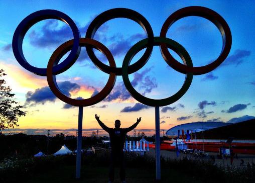
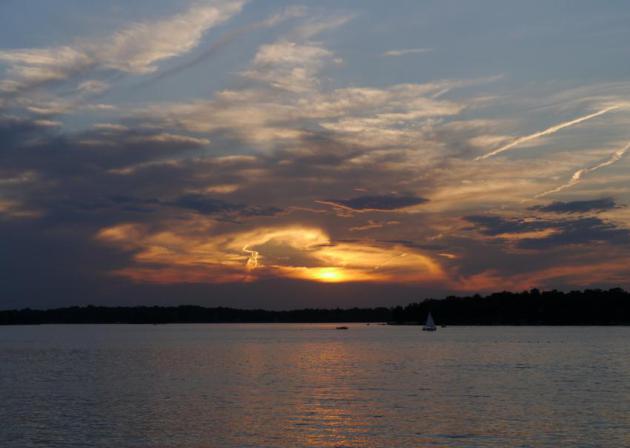
A Rare (Visible!) London Sunset. The weather has
been a bit rugged and ragged on the other side of the pond, frequent
showers, scruffy clouds, temperatures stuck in the 60s. Thanks to Jim
Morrissey for reminding us that, every now and then, London can still
enjoy and Technicolor Sunset.
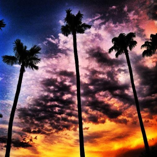
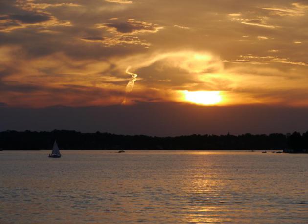
Dreaming Of Scottsdale. O.K. I won't really be
day-dreaming about Scottsdale (and Seaside, Saratoga and Boca Grande)
for another 3-5 months, but I thought this was a spectacular sunset from
Scottsdale, courtesy of L Hudson.
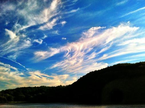
Cirrus Near Us. Thanks to Justin Hamlin, who snapped
this photo of wispy cirrus clouds (ice crystals 25,000 feet above the
ground) near New York City. Sometimes called "mares tails", these highs
clouds are often forerunners of a frontal passage or oncoming storm,
especially if they thicken over time, accompanied by an east breeze and
falling barometer.
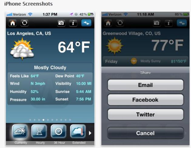
Free WeatherNation App. If you love weather you'll
want to download the new (free) WeatherNation app. Yes, I'm a bit
biased, but there's some great functionality here. For more information
on features in the iPhone version
click here.
This Is How The iPhone 5 Might Look In Your Hand.
Yeah, I'm a fanboy. So what? I've tried Android and IOS, and I prefer
the latter, and yes, I'm looking forward to the next release. So are the
writers over at
Gizmodo, who have an update on possible features; here's an excerpt: "
We have published mockups of Apple's next iPhone—before. But these are the definitive ones, showing what the iPhone 5 or whatever it is called
would look like in your hand. And, as it turns out, it looks pretty
damn good. My favorite is now the black one. I can't really decide. In
black, the new iPhone 2012 is very 1980s, as opposed to the 70s flavor of the current iPhone 4/4S. The two-tone black anodized aluminum is reminiscent of the old AV Sony designs of that decade-like their first CD player."
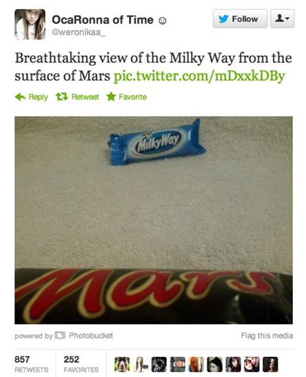
There Are No Words. O.K. This is one of the more clever tweets I've seen in the wake of the NASA mission to Mars, courtesy of
cheezburger.com. Well played.
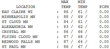
"Warm Enough". Under a flawless blue sky
temperatures were 5-10 degrees above average statewide, ranging from a
high of 83 at Alexandria to 84 St. Cloud, 88 in the Twin Cities.
"
Striving for excellence motivates you; striving for perfection is demoralizing." - Harriet Braiker
Paul's Conservation Minnesota Outlook for the Twin Cities and all of Minnesota:
TODAY: Clouds increase, late shower or T-shower. Dew point: 61. Winds: E 10. High: 78
WEDNESDAY NIGHT: Unsettled, a few showers, possible thunder. Low: 61
THURSDAY: Gray and cool with lot's of clouds, a few lingering showers. Dew point: 59. High: 76
FRIDAY: Partly sunny, better. Dew point: 53. Winds: NE 5-10. Low: 57. High: 77
SATURDAY: More clouds than sun. Dew point: 55. Winds: SE 5. Low; 58. High: 79
SUNDAY: Partly sunny, milder. Dew point: 57. Low: 61. High: 81
MONDAY: Sunny and warmer. Dew point: 63. Low: 65. High: 87
TUESDAY: Fleeting heat. T-storms north. Dew point: 67. Low: 68. High: 91
* ECMWF (European) model guidance is suggesting a
significant cool front the latter half of next week, potentially sweat
shirt-worthy temperatures by next Thursday.
Perfection Optional
"No one is perfect... that's why pencils have erasers."
Weather forecasting is a maddening profession.
You can only learn so much out of a book. The only way to get better is
by making forecasts, and learning from inevitable mistakes. Lots of
mistakes.For 30 years I strived, in vain, for a perfect TV
weathercast. No such thing.
The older I get the more I'm searching for
something far more important: authenticity. Don't sell me or spin me.
Show me something REAL. Something that has meaning.
Today I encourage the 11 meteorologists I work
with to show their humanity. It's OK to mess up, in fact I suspect
viewers like the flubs far more than an antiseptic "perfect" weather
show. "Striving for excellence motivates you; striving for perfection is
demoralizing" said Harriet Braiker. Amen
Speaking of imperfection, a weak clipper-like
disturbance sparks a few showers later today & Thursday,
temperatures cooling into the 60s and 70s. Friday looks sunnier and
drier; no prolonged rain for your weekend plans, with highs near 80. The
lake may be warmer than the air!
Two days near 90 early next week, then a REAL cold front that will have us reaching for jackets by Thursday.
Hang on!
Climate Stories...
"
It's time for us all - whether we're leaders in Washington,
members of the media, scientists, academics, environmentalists or
utility industry executives - to stop acting like those who ignore the
crisis or deny it exists entirely have a valid point of view. They don't." - Senator Harry Reid in Washington D.C. on Tuesday. Details
here.
Study Finds More Of Earth Is Hotter And Says Global Warming Is At Work. Here's an excerpt of a story from Justin Gillis at
The New York Times: "
The
percentage of the earth’s land surface covered by extreme heat in the
summer has soared in recent decades, from less than 1 percent in the
years before 1980 to as much as 13 percent in recent years, according
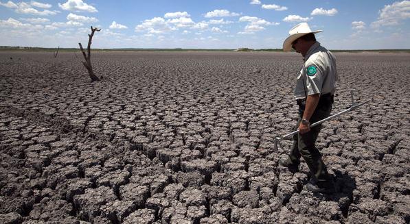
to a new scientific paper. The change is so drastic, the paper says, that scientists can claim with near certainty that events like the Texas heat wave last year, the Russian heat wave of 2010 and the European heat wave of 2003 would not have happened without the planetary warming caused by the human release of greenhouse gases. Those claims, which go beyond the established scientific consensus about the role of climate change in causing weather extremes, were advanced by James E. Hansen, a prominent NASA climate scientist, and two co-authors in a scientific paper published online on Monday in the Proceedings of the National Academy of Sciences."
Photo credit above: Tony Gutierrez/Associated Press. "
A
Texas State Park police officer walked across the lake bed of O.C.
Fisher Lake in San Angelo, Texas. A new scientific paper says that the
drought and other recent extreme weather events have been caused by
global warming."
Climate Change Equals Hot Summers. Case Closed. Here's an excerpt of another perspective on the Hansen research from
Time Magazine: "...
Hansen
and his team looked at the recent past — rather than trying to model
the future — to see if they could find the signature of man-made
climate change through day-to-day and season-to-season weather. They
used the period of 1951–80 as a base because it was a meteorologically
stable stretch that also had a wealth of global weather data, unlike
earlier periods. During that time period, extremely hot summers — like
the one much of the U.S. is experiencing now — occurred only in 0.1% to
0.2% of the globe in a given year. But since 1981, extremely hot
summers have baked about 10% of the earth’s land area annually — and in
recent years, that percentage has been even higher. That means
the odds of experiencing an extreme summer have risen from 1 in 300
during the 1951–80 period to nearly 1 in 10 now, according to Hansen’s
calculations. “I don’t want people to be confused by natural
variability,” he said in a statement. “We now know the chances these
extreme weather events would have happened naturally — without climate
change — is negligible.”
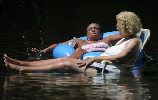
Photo credit above: "
Marcelino Aldama plays with his son,
Raymond, 1, at the Van Nuys Sherman Oaks pool in Sherman Oaks, Calif.,
Tuesday, Aug. 7, 2012. The Aldama's came to the pool to escape this
week's heat wave, which is expected to continue in the triple digits
throughout the week." (AP Photo/Grant Hindsley)
Extreme Weather And Climate Change: Caution Required But Not Reckless Statements. Here's a great guest post at The Washington Post's
Capital Weather Gang; an excerpt: "
In
the wake of punishing heat waves, historic droughts, extensive
flooding and extraordinary melt activity on Greenland, many are asking
if we are seeing long-predicted results of climate change, caused
primarily by man-made heat-trapping greenhouse gas emissions. Recent
studies on extreme events found in an Intergovernmental Panel on Climate Change (IPCC) report and the Bulletin of the American Meteorological Society
suggest that such events may not be attributable to weather
variability alone. They also echo warnings issued by scientists for
decades."
Fred Krup: A New Climate Change Consensus. I almost fell off my couch when I read this in Tuesday's
Wall Street Journal.
Yes, conservatives, liberals and moderates will be able to create
profitable solutions, adapting to this brave, new, stormier world we've
inherited. Here's an excerpt: "
One scorching summer doesn't confirm
that climate change is real any more than a white Christmas proves it's
a hoax. What matters is the trend—a decades-long march toward hotter
and wilder weather. But with more than 26,000 heat records broken in
the last 12 months and pervasive drought turning nearly half of all
U.S. counties into federal disaster areas, many data-driven climate
skeptics are reassessing the issue. Respected Republican leaders like
Govs. John Kasich of Ohio and Chris Christie of New Jersey have spoken
out about the reality of climate change. Rupert Murdoch's recent
tweet—"Climate change very slow but real. So far all cures worse than
disease."—may reflect an emerging conservative view. Even Exxon Mobil
CEO Rex Tillerson, during public comments in June, conceded the reality
of climate change while offering assurances that "there will be an
engineering solution" and "we'll adapt."


 Study Finds More Of Earth Is Hotter And Says Global Warming Is At Work. Here's an excerpt of a story from Justin Gillis at The New York Times: "The
percentage of the earth’s land surface covered by extreme heat in the
summer has soared in recent decades, from less than 1 percent in the
years before 1980 to as much as 13 percent in recent years, according
to a new scientific paper. The change is so drastic, the paper says, that scientists can claim with near certainty that events like the Texas heat wave last year, the Russian heat wave of 2010 and the European heat wave of 2003 would not have happened without the planetary warming caused by the human release of greenhouse gases. Those claims, which go beyond the established scientific consensus about the role of climate change in causing weather extremes, were advanced by James E. Hansen, a prominent NASA climate scientist, and two co-authors in a scientific paper published online on Monday in the Proceedings of the National Academy of Sciences."
Study Finds More Of Earth Is Hotter And Says Global Warming Is At Work. Here's an excerpt of a story from Justin Gillis at The New York Times: "The
percentage of the earth’s land surface covered by extreme heat in the
summer has soared in recent decades, from less than 1 percent in the
years before 1980 to as much as 13 percent in recent years, according
to a new scientific paper. The change is so drastic, the paper says, that scientists can claim with near certainty that events like the Texas heat wave last year, the Russian heat wave of 2010 and the European heat wave of 2003 would not have happened without the planetary warming caused by the human release of greenhouse gases. Those claims, which go beyond the established scientific consensus about the role of climate change in causing weather extremes, were advanced by James E. Hansen, a prominent NASA climate scientist, and two co-authors in a scientific paper published online on Monday in the Proceedings of the National Academy of Sciences."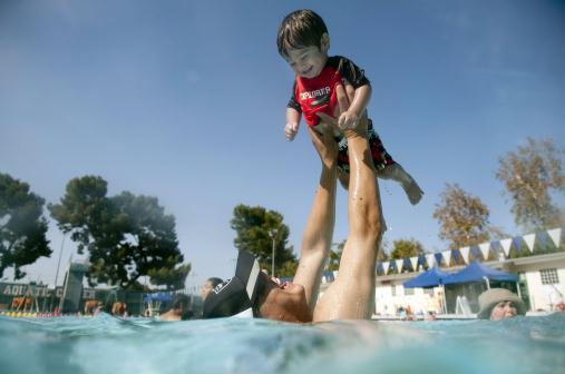 Climate Change Equals Hot Summers. Case Closed. Here's an excerpt of another perspective on the Hansen research from Time Magazine: "...Hansen
and his team looked at the recent past — rather than trying to model
the future — to see if they could find the signature of man-made
climate change through day-to-day and season-to-season weather. They
used the period of 1951–80 as a base because it was a meteorologically
stable stretch that also had a wealth of global weather data, unlike
earlier periods. During that time period, extremely hot summers — like
the one much of the U.S. is experiencing now — occurred only in 0.1% to
0.2% of the globe in a given year. But since 1981, extremely hot
summers have baked about 10% of the earth’s land area annually — and in
recent years, that percentage has been even higher. That means
the odds of experiencing an extreme summer have risen from 1 in 300
during the 1951–80 period to nearly 1 in 10 now, according to Hansen’s
calculations. “I don’t want people to be confused by natural
variability,” he said in a statement. “We now know the chances these
extreme weather events would have happened naturally — without climate
change — is negligible.”
Climate Change Equals Hot Summers. Case Closed. Here's an excerpt of another perspective on the Hansen research from Time Magazine: "...Hansen
and his team looked at the recent past — rather than trying to model
the future — to see if they could find the signature of man-made
climate change through day-to-day and season-to-season weather. They
used the period of 1951–80 as a base because it was a meteorologically
stable stretch that also had a wealth of global weather data, unlike
earlier periods. During that time period, extremely hot summers — like
the one much of the U.S. is experiencing now — occurred only in 0.1% to
0.2% of the globe in a given year. But since 1981, extremely hot
summers have baked about 10% of the earth’s land area annually — and in
recent years, that percentage has been even higher. That means
the odds of experiencing an extreme summer have risen from 1 in 300
during the 1951–80 period to nearly 1 in 10 now, according to Hansen’s
calculations. “I don’t want people to be confused by natural
variability,” he said in a statement. “We now know the chances these
extreme weather events would have happened naturally — without climate
change — is negligible.” Extreme Weather And Climate Change: Caution Required But Not Reckless Statements. Here's a great guest post at The Washington Post's Capital Weather Gang; an excerpt: "In
the wake of punishing heat waves, historic droughts, extensive
flooding and extraordinary melt activity on Greenland, many are asking
if we are seeing long-predicted results of climate change, caused
primarily by man-made heat-trapping greenhouse gas emissions. Recent
studies on extreme events found in an Intergovernmental Panel on Climate Change (IPCC) report and the Bulletin of the American Meteorological Society
suggest that such events may not be attributable to weather
variability alone. They also echo warnings issued by scientists for
decades."
Extreme Weather And Climate Change: Caution Required But Not Reckless Statements. Here's a great guest post at The Washington Post's Capital Weather Gang; an excerpt: "In
the wake of punishing heat waves, historic droughts, extensive
flooding and extraordinary melt activity on Greenland, many are asking
if we are seeing long-predicted results of climate change, caused
primarily by man-made heat-trapping greenhouse gas emissions. Recent
studies on extreme events found in an Intergovernmental Panel on Climate Change (IPCC) report and the Bulletin of the American Meteorological Society
suggest that such events may not be attributable to weather
variability alone. They also echo warnings issued by scientists for
decades." Fred Krup: A New Climate Change Consensus. I almost fell off my couch when I read this in Tuesday's Wall Street Journal.
Yes, conservatives, liberals and moderates will be able to create
profitable solutions, adapting to this brave, new, stormier world we've
inherited. Here's an excerpt: "One scorching summer doesn't confirm
that climate change is real any more than a white Christmas proves it's
a hoax. What matters is the trend—a decades-long march toward hotter
and wilder weather. But with more than 26,000 heat records broken in
the last 12 months and pervasive drought turning nearly half of all
U.S. counties into federal disaster areas, many data-driven climate
skeptics are reassessing the issue. Respected Republican leaders like
Govs. John Kasich of Ohio and Chris Christie of New Jersey have spoken
out about the reality of climate change. Rupert Murdoch's recent
tweet—"Climate change very slow but real. So far all cures worse than
disease."—may reflect an emerging conservative view. Even Exxon Mobil
CEO Rex Tillerson, during public comments in June, conceded the reality
of climate change while offering assurances that "there will be an
engineering solution" and "we'll adapt."
Fred Krup: A New Climate Change Consensus. I almost fell off my couch when I read this in Tuesday's Wall Street Journal.
Yes, conservatives, liberals and moderates will be able to create
profitable solutions, adapting to this brave, new, stormier world we've
inherited. Here's an excerpt: "One scorching summer doesn't confirm
that climate change is real any more than a white Christmas proves it's
a hoax. What matters is the trend—a decades-long march toward hotter
and wilder weather. But with more than 26,000 heat records broken in
the last 12 months and pervasive drought turning nearly half of all
U.S. counties into federal disaster areas, many data-driven climate
skeptics are reassessing the issue. Respected Republican leaders like
Govs. John Kasich of Ohio and Chris Christie of New Jersey have spoken
out about the reality of climate change. Rupert Murdoch's recent
tweet—"Climate change very slow but real. So far all cures worse than
disease."—may reflect an emerging conservative view. Even Exxon Mobil
CEO Rex Tillerson, during public comments in June, conceded the reality
of climate change while offering assurances that "there will be an
engineering solution" and "we'll adapt."
No comments:
Post a Comment