83 F. high yesterday in the Twin Cities.
81 F. average high for August 15.
84 F. high on August 15, 2011.
.73" rain fell in the 24 hour period as of 7 pm Wednesday.
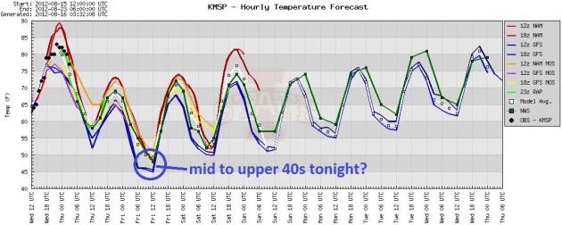
45 degree temperature swing? Lows dip into the mid
to upper 40s tonight in the suburbs. Long-range (ECMWF) model guidance
is hinting at 90+ temperatures returning in about a week. Details below.
Where's That Sweatshirt? If you're up late tonight
or first thing Friday you may see 40s on your back yard thermometer,
especially in the suburbs. Temperatures bottom out late tonight, and
then slowly warm right into next week.
Enjoy The Cool Front - More 90+ Readings Late Next Week?
The ECMWF has been doing a pretty good job looking out beyond 4 days,
isolating longer term trends in moisture and temperature. After a
comfortable weekend the European model is hinting at highs near 90 the
latter half of next week. Something to look forward to.
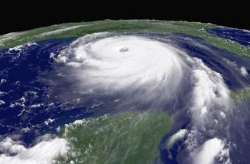
August 15 marks the start of what is, historically, the most active 30-day period for hurricane activity in the Atlantic and Caribbean.
$ 15.97 trillion dollars: America's debt.
$ 15.3 trillion dollars: 2012 GDP (Gross Domestic Product). Source: Bloomberg. Photo: AP,
Business Insider.
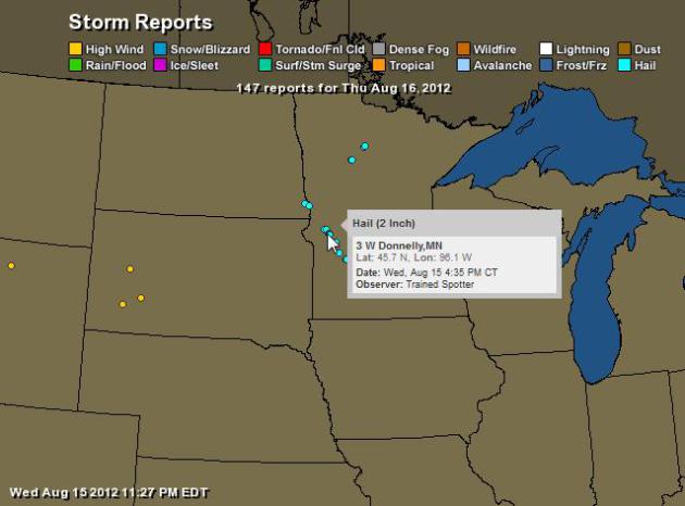
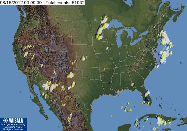
Wednesday Storm Reports. Hail as large as 2" in
diameter was reported near Donnelly, Minnesota at 4:35 pm yesterday, but
the storms weakened as they approached the metro area. Map courtesy of
NOAA and
Ham Weather.
Weather Gone Wild. Here's an excerpt of an excellent cover story in this month's
National Geographic Magazine: "...
There’s
been a change in the weather. Extreme events like the Nashville
flood—described by officials as a once-in-a-millennium occurrence—are
happening more frequently than they used to. A month before Nashville,
torrential downpours dumped 11 inches of rain on Rio de Janeiro in 24
hours, triggering mud slides that buried hundreds. About three months
after Nashville, record rains in Pakistan caused flooding that affected
more than 20 million people. In late 2011 floods in Thailand submerged
hundreds of factories near Bangkok, creating a worldwide shortage of
computer hard drives. And it’s not just heavy rains that are making
headlines. During the past decade we’ve also seen severe droughts in
places like Texas, Australia, and Russia, as well as in East Africa,
where tens of thousands have taken refuge in camps. Deadly heat waves
have hit Europe, and record numbers of tornadoes have ripped across the
United States. Losses from such events helped push the cost of weather
disasters in 2011 to an estimated $150 billion worldwide, a roughly 25
percent jump from the previous year. In the U.S. last year a record 14
events caused a billion dollars or more of damage each, far exceeding
the previous record of nine such disasters in 2008."
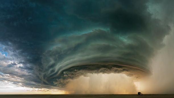
Photo credit above: "
Supercell thunderstorm near Glasgow, Montana." Photograph by Sean R. Heavey, Barcroft Media/Landov.
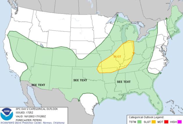
Thursday Severe Risk. An eastbound cool front may
spark another rash of strong to potentially severe T-storms from near
Chicago and South Bend to St. Louis and Louisville.
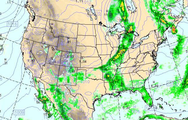
Today's Weather Map. The WRF model, valid at 4 pm
today, shows another surge of September-like air sparking a swatch of
strong to severe storms from the Great Lakes into the Ohio Valley. The
east coast dries out, storms popping over Florida, the west still
unusually dry and hot. A strong pressure gradient (a big difference in
barometric pressure) whips up 30 mph plus winds over Minnesota and
Wisconsin.
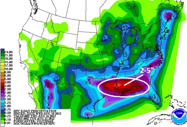
Southern Soaking. NOAA HPC is predicting some 2-5"
rainfall amounts by next Tuesday from the parishes of Louisiana into the
Florida Panhandle; dry weather the rule over the western third of the
USA.
Lightning Explorer. Looking for lightning data, preferably for free? You may not be able to do better than Lightning Explorer, from
Vaisala.
One word of caution: data is delayed by 20 minutes. This is NOT
real-time lightning information (which comes with a charge from any
weather company, including my own, Ham Weather). But using Explorer you
can see if lightning is nearby, and see the direction of motion of
T-storm cells (the most recent strikes show up as white on the map). A
useful tool.
Preparing Your Home For A Hurricane. Here's a very timely story from
The Washington Post; an excerpt: "...
First,
Kahn recommends buying C and D batteries. They were the first things
to fly off the shelves during the derecho, he said. Then, stock up on
flashlights, A-cell batteries, toiletries, fans and emergency cooking
supplies such as grills or hot plates that work on propane. “As soon as
something like this is projected to hit, the battery-operated stuff
gets wiped out immediately the same way bread disappears when a
blizzard is coming,” he said. “So it’s in your best interests to skip
that step and keep a small reserve handy.” When it comes to prepping
your home for a hurricane, the two biggest threats are roof damage and
flooding. Claude McGavy, the executive director of the National Association of Home Inspectors, said both are severely underestimated."
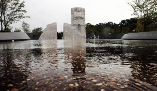
Photo credit above:
Pablo Martinez Monsivais/AP - "
The Martin Luther King Memorial is seen the morning after Hurricane Irene moved through the East Coast in 2011."
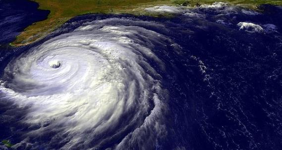
Study: Freshwater Helps Hurricanes Strengthen Faster. I had no idea - more breaking research on the hurricane front; here's an excerpt from
The Petri Dish: "...
Hurricanes feed off of fresh water, according to a report
from the Pacific Northwest National Laboratory. Researchers at the
PNNL, Texas A&M University and the Ocean University of China
examined ten years worth of data from tropical cyclones and found that
when hurricanes move over ocean regions ripe with fresh water, they can
quickly intensify. While researchers believe that the probability of
hurricanes moving over fresh water is only 10 to 23 percent, the impact
of the occurrence is quite dramatic. In fact, researchers think that a
hurricane under such conditions can become 50 percent more intense.
The findings are reported in a study that will be published this week
in the Proceedings of the National Academy of Sciences Early Edition."
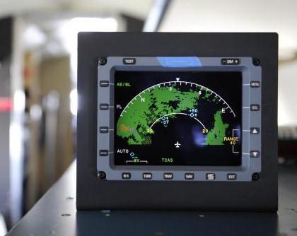
Aircraft Radar Shows Pilots Airspace In 3-D. A local
firm, Honeywell, is getting some well-deserved attention over a new way
to visualize weather, up in the air. I hope my next Delta flight has
this innovation (especially when I'm bumping my way across the Rockies).
USA Today has the story; here's an excerpt: "...
For
the first time, the new radar, now being installed in business,
military and commercial aircraft, allows pilots to "see" turbulence
and other bad weather such as lightning and hail from nearly 70 miles
away. The radar, manufactured by Honeywell, "looks at the airspace in
front of the aircraft in three dimensions, which is an improvement over
existing radars," says Honeywell senior chief engineer Ratan Khatwa.
Current radars used by pilots now take only a two-dimensional slice of
the atmosphere, the width and length, for instance, of storms crossing
an area. "It provides information to the flight crew where the real
weather hazards such as lightning and hail are which is not available
today," he says."
Photo credit above: By H. Darr Beiser, USA TODAY. "
Honeywell's on-board aircraft radar gives pilots a better picture of storms and inclement weather in their path."
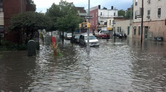
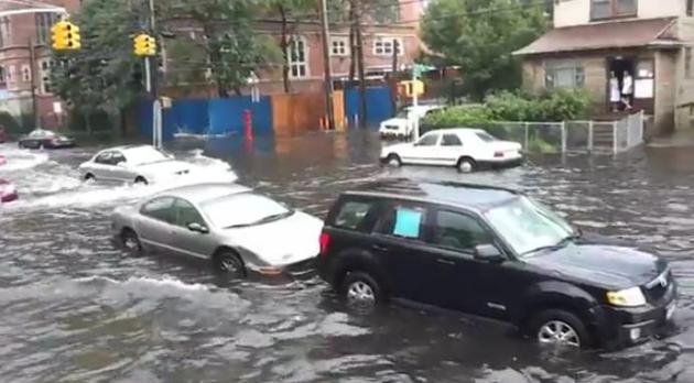
Yesterday Put The "Brook" In Brooklyn. Thanks to Twitter and
Jezerific for sharing this pic. Cue the instant lake.
Flash Flood. Flooding was extensive across metro New
York yesterday, a "train-echo" effect, with T-storms redeveloping over
the same counties and boroughs during the afternoon and evening, dumping
some 2-4" amounts. Here's a
YouTube clip of flooding at Coney Island, New York from
jr18547 who wrote "
As always, Coney Island is flooded due to poor storm drainage".
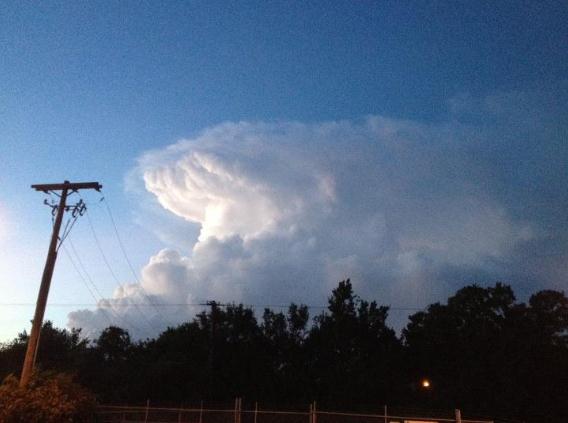
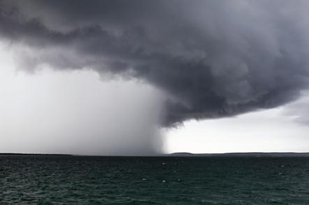
Towering Trouble. Thanks to the National Weather Service office in Tampa for snapping this photo of a sprouting cumulonimbus on Wednesday.
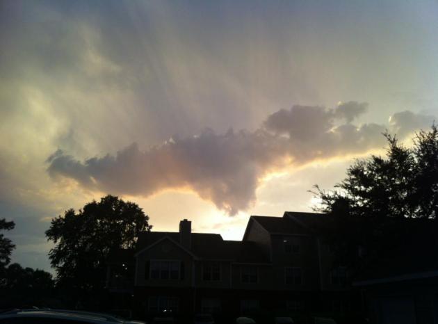
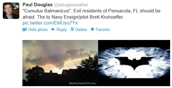
One Unusual Cloud. Ensign Brett Kruhoeffer, based in
Pensacola (where he's training to fly helicopters for the Navy) shared
this strange-looking cloud on Tuesday. What the heck is that thing? Wait
a minute....
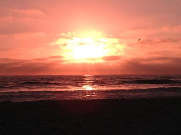
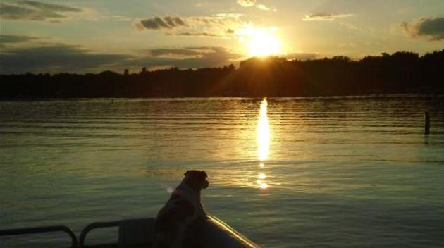
Tranquility Base. Thanks to Leslie Berg, who captured the serenity of a Mission Beach, California sunset.
"Ask Paul". Weather-related Q&A:
Paul,
Our trip out west to Yellowstone and Grand Tetons was super. I
experienced "dry lightning" and saw an actual wall cloud on the way out
there. The wall cloud held together only about 10-15 minutes, but had a
decent thunderstorm with it. You know that smell you have when rain is
darn near your doorstep or during the first few minutes of a shower,
usually most noticeable during sprinkles?
Well, when we actually did encounter rain out west, there wasn't an
odor with the rain.The one band of T-storms we saw on the way out had
what I call a rain-cooled fresh smell. Was in the low 90s with a breeze
from the south but the storm we had saw winds change from the north, and
when the rain came though, temperatures fell 25 degrees. The rain
events that didn't smell were east of Rapid City, and once in Jackson
Hole, Wyoming.
Any reason why the rain out there didn't smell?
Thanks.
Aaron Coates
Hennepin County Sheriff's 911
Golden Valley
Aaron - there is considerable debate about the source of this smell
(usually found before a rainfall). The best answer I could find was from
thenakedscientists.com (great name for a web site, huh?). Paul writes: "
the
smell after rain is actually the smell of bacteria - actinomycetes.
They grow worldwide in damp soil. When the soil dries out, they die. But
before they die, the make spores. These spores are really tough and can
survive dry conditions for years. When raindrops hit the ground they
make a mist of water and dirt, which you both breathe in and smell."
Why didn't you smell this in South Dakota or Wyoming? It may be a
function of topsoil. Here in the Midwest we have rich, deep loamy
topsoil, the envy of the world in many respects. But the farther west
you go the thinner the topsoil becomes (and the fewer spores available
to mix with rain). That's the only thing I can think of offhand. Thanks
for a great question!
The Science Of Cute. I found this
gizmag.com article interesting - how do our brains calculate "cute"? Here's an excerpt: "
Let’s
pretend that a mewling, pooping annoying small thing is deposited in
your lap. It needs constant input from you. Before long, it’s taken
over your life. You find yourself lavishing attention on this new
creature. Going out is a distant memory. But the thing is, the new baby
is cute. Really cute. You can’t help but feel protective. You want to
look after it. But why? Why do small helpless things – babies, kittens,
puppies, pandas in baby form – turn even the most cynical human into a
helpless wreck? Why don’t we have the same reaction to a baby lizard or
fish or bird? What, in short, is this cuteness thing all about?"
Daydreaming Of The Weekend. Under a partly sunny sky
highs reach the low to mid 70s over the weekend, low humidity and light
winds generally from the north to northwest. The ECMWF is showing a few
spotty showers and sprinkles Sunday afternoon. Right now Saturday
appears to be the sunnier, drier day of the weekend.
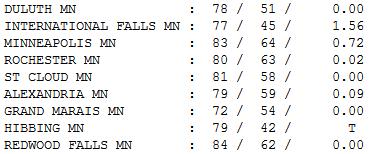
Sun & Thunder. Temperatures shot up into the 80s
over central and southern Minnesota; 70s up north. International Falls
picked up a whopping 1.56" of rain yesterday as of 7 pm. High ranged
from 72 at Grand Marais to 81 St. Cloud, 83 in the Twin Cities and 84 at
Redwood Falls.
Paul's Conservation Minnesota Outlook for the Twin Cities and all of Minnesota:
TODAY: A mix of cool sun and scrappy cumulus,
windy and cool (for mid-August). Winds: NW 15-30. Dew point: 48.
High: near 70 (60s for greater Minnesota).
TONIGHT: Clearing, bordering on chilly! Low: 50 (40s possible outside the metro).
FRIDAY: Sunny, less wind. It should feel like late September. Winds: NW: 10-15. Dew point: 43. High: 72
SATURDAY: Plenty of sun. Winds: W 5-10. Dew point: 44. Low: 55. High: 74
SUNDAY: Sunny start - clouds increase. Winds: NW 5-10. Dew point: 47. Low: 57. High: 76
MONDAY: Mix of clouds & sun, slight chance of an isolated shower. Low: 59. High: 78
TUESDAY: Warm sun, still dry. Dew point: 57. Low: 63. High: 84
WEDNESDAY: Hazy sun, almost hot. Dew point: 61. Low: 67. High: near 90
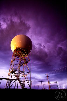
Dual Polarization Doppler
For the record, I did not invent Doppler. People
come up on the street and congratulate me. Right. 3-D TV weather
graphics, weather on cell phones (now owned by Garmin) and a new
national weather channel? Yes, but I had a lot of help.
The local National Weather Service has just
completed an upgrade to "dual polarization", a software & hardware
tweak that has meteorologists excited. Why? By transmitting horizontal
and vertical pulses of energy the new Doppler does a better job
estimating the size of "hydrometeors" - raindrops, snowflakes &
hailstones - giving us a new tool to estimate precipitation amounts and
gauge the severity of flash flooding, snowfall potential, etc. It's so
sensitive it can even detect a tornado's "debris ball", the dirt and
rubble kicked up into the air by a tornado circulation on the ground. In
time tornado false alarm rates may come down.
Nothing on Doppler today; stiff northwest winds
reach 30 mph as another taste of September sweeps across Minnesota.
Winds ease Friday as high pressure passes overhead; a weekend of 70s
& sun. Not bad. No more rain is in sight into next week.
Miss the heat? No nasty-90s brewing, but I see a streak of 80s just in time for The State Fair!
* image above courtesy of the Twin Cities National Weather Service and Reid Wolcott.
Climate Stories...
Talk Climate Change Solutions, Win Votes: Yale Study. Here's an excerpt of an intriguing story from
treehugger.com: "
Conventional
beltway wisdom holds that if you're running for office, you don't
touch climate with a ten foot pole. It's considered "politically
toxic," albeit by a cohort that tolerates birtherism and Donald Trump
participating in the political process. So unless you're gunning to
represent one of those wacky radical leftist states like Vermont or
California or Massachusetts, any meaningful engagement on climate
issues is off the table. The politicos say so. Obama took the hint; he
almost never mentions global warming in public. Romney's mum, too. But new Yale research
(pdf) says that conventional wisdom is probably wrong. A new study
from the Yale Project on Climate Change Communication finds that there
are indeed a group of climate issues voters who will be more likely to
support a candidate who's pro-climate."
Photo credit above:
Wikimedia Commons/CC BY 2.0
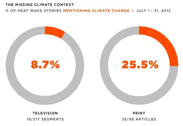
Study: TV Media Ignore Climate Change In Coverage Of Record July Heat Wave. Here's an excerpt from
Media Matters: "
Scientists
say that human-induced climate change made this year's record heat
more likely, and project that extreme heat will become more common in
the United States. But a Media Matters analysis of media coverage of
record-breaking heat in July finds that major television outlets rarely
made the connection between heat waves and a changing climate. Only 14% Of Heat Wave Stories Mentioned Climate Change. In
a study of major media outlets, only 8.7% of television segments and
25.5% of print articles reported on record-breaking July heat waves in
the context of climate change."
Urban Heat Island Effect And Climate Change May Cause Scorching Summer Temperatures.
It's a potential double-whammy: excess heat radiating up from concrete
and asphalt, coupled with warming background temperatures. Here's an
excerpt of a story from Climate Central and
Huffington Post: "
For
scientists who worry about climate change, cities are just plain
annoying. The acres of asphalt that cover roads and parking lots and
roofs absorb enormous amounts of heat. In the summer, whirring air
conditioners channel even more heat out of buildings and into the air. Climate scientists have to subtract this so-called urban heat island effect
from their calculations if they want to get a true picture of how
greenhouse gas emissions are warming the planet. For people who actually
live in cities, however the urban heat island effect is more than just
a mathematical annoyance. If you’re sweltering on a hot summer day,
your body doesn’t much care where the heat is coming from. And
according to a paper just published in Nature Climate Change,
urbanization alone could drive local temperatures up by a whopping 7°F
by 2050 in some parts of the U.S. — some two or three times higher
than the effects of global warming (which would also be going on at the
same time)."
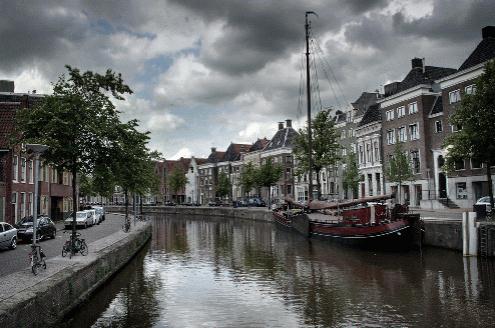
Leading By Example: The Dutch Prepare For Climate Change. Here's an excerpt of an interesting article at
opednews.com: "...
The
Netherlands is a country particularly vulnerable to rising sea levels,
as two-thirds of its population lives below sea level. Throughout its
history, the Dutch have understood the inevitability of change and how
society must work with nature for effective strategies. In 2007, the
Dutch began preparing for the changing climate in the upcoming two
hundred years. They recognize that their nation will continue to combat
rising seas, and must act expeditiously in order to prevent further
encroachment. In State of the World 2012,
Erik Assadourian outlines the 200-year plan put forth by the Dutch,
describing their strategy to spend $1 billion a year on climate change
adaptation. Through such policies, it is clear that the Netherlands is
focused on the long-term public interest and not short-term private
interests. The Dutch plan
combines innovative techniques like building surge barriers and
extending the coastline, with more traditional methods, such as
fortifying levees."
Photo credit above: "
Old Dutch canal." (Photo via Flickr, by Joepydo)
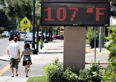
Methane From Fracking Triggers Climate Change. From
what I understand about hydro-fracking, an important (and in my humble
opinion - vital) energy source for America going forward, with far less
greenhouse gas emissions than coal or oil, it would cost an additional
7% for operators to clean up fracking operations, so they won't pollute
groundwater supplies or leak methane from drilling sites. There is a lot
of concern about the environmental impacts of "fracking". Here's an
excerpt of an Op-Ed at
syracuse.com: "
Far
from being a climate solution, fracking may be a disaster for our
climate. Research indicates the methane leakage may mean that fracking
is worse for the climate than coal and oil, particularly in the short
term. Gas from fracking is mostly methane, a dangerous greenhouse gas
that is up to 105 times more powerful at trapping heat in the
atmosphere than carbon dioxide over 20 years. A recent United Nations
Environment Program report shows that it is more urgent to reduce
methane than CO2, given that methane is so much more powerful, has
quicker climate impacts and will trigger runaway climate change sooner.
According to the Nobel-prize-winning Intergovernmental Panel on
Climate Change, we must immediately reduce our greenhouse gas emissions
to avoid dangerous tipping points for the climate. Failing to do so
will cause catastrophic impacts, far worse than the extreme heat and
droughts this summer."
Photo credit above:
AP Photo/The Fresno Bee, Craig Kohlruss. "A
sign on a building Friday reads 107 degrees in Clovis, Calif. A recent
United Nations Environment Program report shows the need to reduce
methane, which is released by fracking, since the gas traps heat in the
atmosphere."


No comments:
Post a Comment