78 F. high yesterday in the Twin Cities (Twin Cities International Airport).
81 F. average high for August 14.
84 F. high last year, on August 14, 2011.
Trace of rain fell at KMSP yesterday.
.39" rain predicted today and tonight (best chance of heavy showers and storms tonight). NAM model.
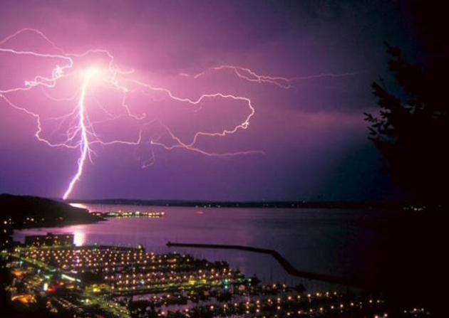
Slight severe storm risk this evening and early tonight.
20-30 mph wind gusts tomorrow, from the northwest, on the backside of tonight's cool frontal passage.
89 minutes. We've lost almost an hour and a half of daylight since the June 20 Summer Solstice. Sniff.
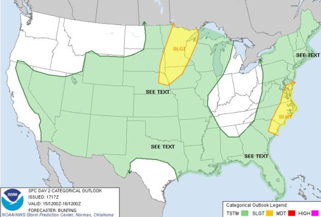
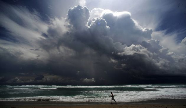
Wednesday Severe Threat. An eastbound cool front
sparks strong to severe T-storms later today from Duluth to the Twin
Cities and Des Moines. A second area of storms may exceed severe limits
from Washington D.C. southward to the Outer Banks and Charleston. Map:
SPC.
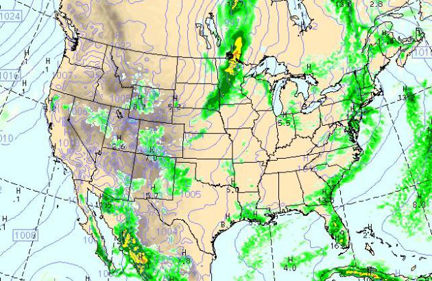
7 PM Weather Map. Here is the predicted weather map
for this evening; showing the next surge of Canadian air pushing across
the Upper Midwest, showery rains fro New England southward to the
Carolinas. Record heat continues to bake the far west (fanning more
brushfires over the Pacific Northwest). Map above: NOAA WRF.
Cooling Down - Summer Rerun Next Week. The good
news: no more oppressive heat, at least looking out through the end of
August. I still think we'll see a few more days above 90, but no sticky,
sweaty days are imminent. If the sun is out for a few hours today
(likely) we should see mid to upper 80s; 90 possible south/west of MSP.
We cool off 15-20 degrees tomorrow on gusty northwest winds, weekend
highs in the low to mid 70s. 80s return next week, according to the
latest ECMWF model above.
Weekend Preview. This weekend lake water
temperatures may be warmer than air temperatures. Expect a light north
breeze and a partly sunny sky. Nights will be cool: upper 40s to mid
50s. Days lukewarm with highs in the low to mid 70s. With a dew point
ranging from 40-50 F. it should feel pretty good out there.
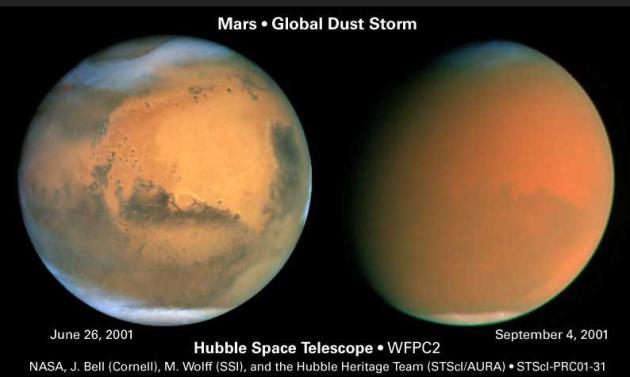
-200 F. Average nighttime low on Mars. Details from Florida Today below. Photo sequence:
NASA.
"...
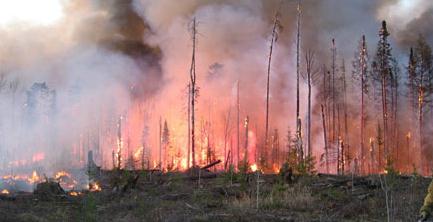
Nationwide (but mostly in the West), wildfires burned an average of 6.9 million acres per year from 2002-2011, almost double the average acreage of the previous decade." - from a Climate Central article below. Photo: DNR.
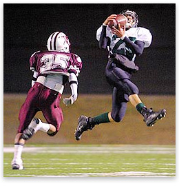
"Across the country, deaths of high school football players due
to heat nearly tripled from 1994 to 2009 compared to the previous 15
years, according to Grundstein's study..." - from a Scientific
American article on the impact of a warming climate on high school
football practices nationwide. Photo credit
here.
"
The Centers for Disease Control (CDC) published a study
in August 2010 that concluded heat illness is the leading cause of
death and disability among American high school athletes. The CDC
estimated that heat stress is responsible for an average of more than
9,000 heat illnesses among high school athletes annually and that
football players are 10 times more likely to experience heat illness
than students who played the eight other surveyed sports." - from a Union of Concerned Scientists press release; details below.
"
The ten warmest consecutive 12-month periods in recorded history
for the United States have occurred since 2000, according to the U.S.
National Oceanic and Atmospheric Administration. August 2011 to July
2012 was the warmest 12-month period that the contiguous United States
has ever experienced; July registered as the warmest month the nation
has ever seen, eclipsing a record set in the Dust Bowl, according to NOAA.
Might there come a time when the climate in the South is just too
oppressive for summer football workouts? "I think you can do it safely,
but you have to really monitor," Grundstein said. "I do think it's
really important to have a policy in place because you're only going to
get more days that are really oppressive." - from a
Daily Climate article.
"
The main thing we have to deal with in climate change is
skepticism and denial, and the cult-like behavior of political lemmings
that would take us over the cliff....There are powerful wealthy
forces] that want to crush any effort to cope with climate change." - California Governor Jerry Brown, quoted in a Huffington Post article below.
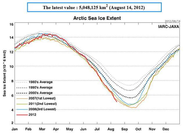
Arctic Sea-Ice Monitor. We are on track for record ice loss in the Arctic. Graph:
Japan Aerospace Exploration Agency. More details below.
"
The 2012 edition of the risk atlas identified 30 countries as
being at extreme risk. The top 10 most at risk include: Haiti,
Bangladesh, Sierra Leone, Zimbabwe, Madagascar, Cambodia, Mozambique,
Democratic Republic of Congo, Malawi and the Philippines....The
countries in the best position to adapt to climate change's challenges
mostly include those in Northern Europe, such as Finland, Ireland,
Sweden and Norway, CNN reported. Iceland topped the list, but the United States also had a relatively low risk rating." - from a Live Science article below focused on nations most at risk from climate change.
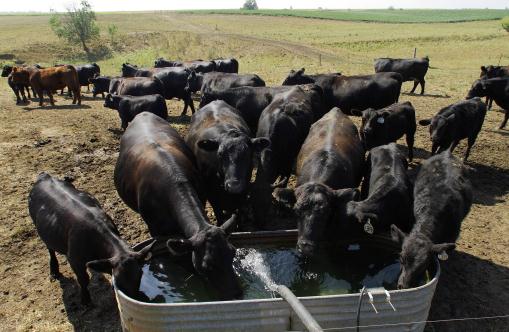
Sizzling July Temperatures Shatter Records. Some interesting statistics in this article from
The Drovers Cattle Network; here's a snippet: "
This
season has been the summer of frustrating forecasts stuck on a vicious
repeating cycle. Wave after wave of unrelenting heat combined with few
rain-making systems, causing headaches for much of the nation’s
heartland. Drought has expanded now to nearly 63 percent of the
continental United States, and the areas of the country in the worst
categories of drought have doubled from 10 percent last month to 22
percent. The National Oceanic and Atmospheric Administration (NOAA)
released an update to its State of the Climate report
on Wednesday, and it came as no surprise that July 2012 will be one for
the history books. Data for the month shows that July was the hottest
month on record for contiguous United States with an average
temperature of 77.6 degrees F, which is 3.3 degrees above the 20th
century average. The previous warmest July was in 1936 when temperature
averaged 77.4 degrees."
Photo credit above: "
Tony Frost of Frost Farms, not
pictured, tops off a stock tank with water for his cattle on Aug. 3,
2012 in Tallula, Ill.. After months of drought, the central Illinois
creeks and ponds that the 300 cows and calves drink from on the Frost
Farms are dry or close to it. Frost has to buy and haul water, about
4,000 gallons a day, split up in four trips to different pastures." (AP Photo/Seth Perlman)
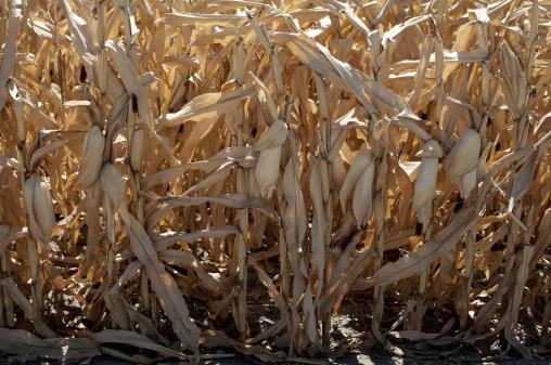
New Technology May Help In Future Droughts. Some encouraging news in a story at
syracuse.com; here's an excerpt: "
Cattle
are being bred with genes from their African cousins who are
accustomed to hot weather. New corn varieties are emerging with larger
roots for gathering water in a drought. Someday, the plants may even be
able to “resurrect” themselves after a long dry spell, recovering
quickly when rain returns. Across American agriculture, farmers and crop
scientists have concluded that it’s too late to fight climate change.
They need to adapt to it with a new generation of hardier animals and
plants specially engineered to survive, and even thrive, in intense
heat, with little rain. “The single largest limitation for agriculture
worldwide is drought,” said Andrew Wood, a professor of plant
physiology and molecular biology at Southern Illinois University. On
his Kansas farm, Clay Scott is testing a new kind of corn called
Droughtguard as his region suffers through a second consecutive growing
season with painfully scarce precipitation."
Photo credit: Missouri Valley, Iowa, on August 13, courtesy of Carolyn Kaster, AP.
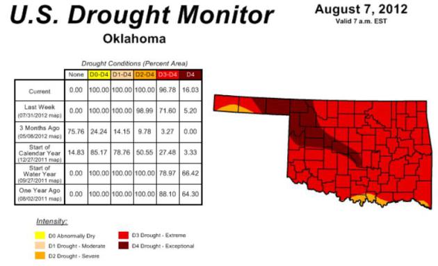
Extreme To Exceptional Drought Covers Most Of Oklahoma. Here's an update from the
Oklahoma Mesonet: "
Spurred
by the rapidly intensifying flash drought and its impacts, including
the extreme fire danger realized in the state over the last week, the
U.S. Drought Monitor has now designated virtually all of Oklahoma in
extreme to exceptional drought. Nearly 97 percent of the state is now
depicted by the Drought Monitor in those worst two drought intensities,
the highest such coverage for the state since the Drought Monitor
effort began in 2000. A narrow swath of exceptional drought extends
from Cleveland and McClain counties in central Oklahoma to the
northwest, where it broadens and covers much of western Kansas. The next
highest percentage of extreme to exceptional drought was 93 percent
from the same week last year on August 9, 2011. The percentage of
exceptional drought itself is only 16 percent, while the August 9 map
from 2011 had 65 percent of the state designated in that most intense
drought category. Over 103,000 acres have burned due to wildfire across
the state since Aug. 3. One fatality has been attributed to a wildfire
east of Norman."
* the latest U.S. Drought Monitor for Oklahoma is
here.
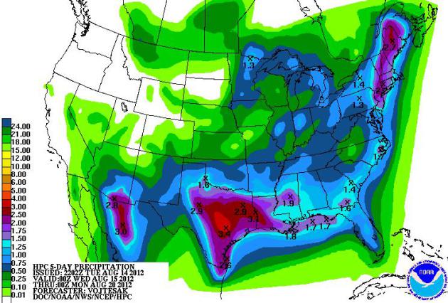
Record Heat Diminishes. The heat wave is pretty much
winding down for most of the USA, with the exception of the far western
part of America. Over the next 5 days Texas may get soaked with some
1-3" amounts, thundery weather forecast for the Gulf Coast, with ample
rains for much of New England. Map: NOAA HPC.
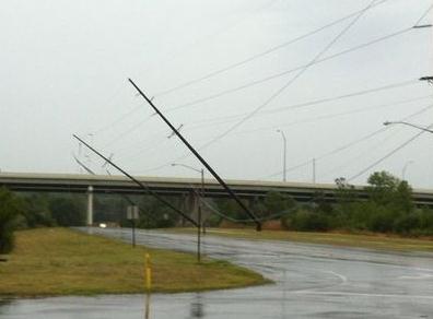
June's Wind Storm Third Costliest Ever. The derecho
that raged across Ohio in late June may have triggered half a billion
dollars in damage. More details in this article from
The Dayton Daily News: "
The
“derecho” wind storms of late June and early July were the third-most
expensive natural disaster in Ohio in 38 years. Only the tornado
outbreak in Xenia in 1974 and the hurricane-borne winds of 2008 created
costlier damage, according to an insurance trade association. Statewide
preliminary estimates put insured losses at $433.5 million to $440
million for the June 28-July 4 period, the Ohio Insurance Institute
said."
Photo credit above: "
On Kauffman Avenue in Fairborn, Ohio." Chris Stewart.
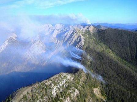
Forest Service Fights All Fires Now, But At What Cost? Fire is a natural part of life and ecology. The problems arise when people build homes in fire-prone regions.
Climate Central has an interesting article; here's an excerpt: "
On
July 12, lightning sparked a forest fire in western Montana’s Bob
Marshall Wilderness Complex — a place where wildfires are common this
time of year. Usually, if they’re small and don’t threaten to get out of
control, the U.S. Forest Service will let them burn. Small fires are
good for the forest ecosystem, burning off dead timber and creating
habitat for many woodland species; because of that, all U.S. agencies
adopted a policy in 1995 to reintroduce fire on federal land. So what
happened last month was unusual: the U.S. Forest Service, which manages
the 1.5 million-acre Bob Marshall Wilderness Complex and an additional
35 million acres of federally designated wilderness land
nationwide, ordered a full-on attack of the fire by smokejumpers,
bucket-bearing helicopters, and four lumbering slurry bombers that each
dumped more than 2,000 gallons of red chemical fire retardant on an
ecosystem that is otherwise treated as pristine."
Photo credit above: "
Fire burns along a ridge in western Montana's Bob Marshall Wilderness Complex." Credit: U.S. Forest Service.
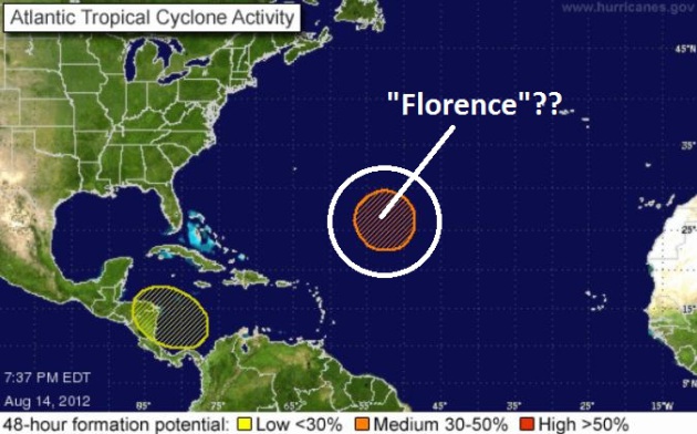
Tropical Storm "Florence".
NOAA NHC
(National Hurricane Center) now says there's a 50% probabilityy that a
tropical disturbance will strengthen into a tropical storm. Next up on
the list of names....Florence.
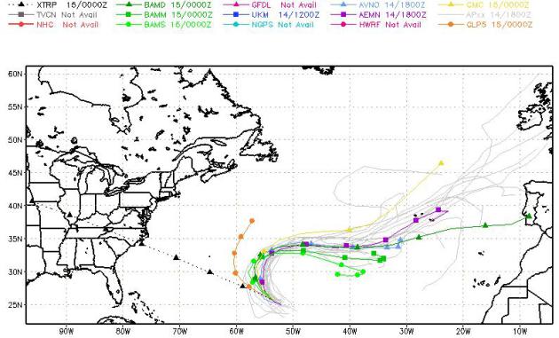
No Worries. Prevailing jet stream winds will
probably cause "Florence" to recurve to the north, and then east, away
from the USA. Only 1 out of 15 weather models brings Florence into the
USA, near the Outer Banks. So far so good.
Anniversary Of Hurricane Charley. Charley was a remarkable hurricane; tight, compact, taking an unusual track into the Sarasota/Ft. Myers region of Florida.
The Herald Tribune has a great recap of the storm; here's an excerpt: "
The
hurricane season seemed calm and quiet in 2004, until August, when
Hurricane Charley struck Punta Gorda with ferocious 140 mph winds.
Charley – the third named storm that year – made its first landfall in
Cayo Costa and its second in Punta Gorda shortly before 4 p.m. eight
years ago today. Although it was a powerful storm its strongest winds
spanned only 6 miles from its eye – one of the tiniest hurricanes on
record. It was so small that some people have begun to liken it to a
giant tornado, rather than a hurricane. Despite its small size, the
Category 4 hurricane devastated Punta Gorda and large parts of
Charlotte County before ripping a narrow path of destruction across the
state, all the way to the east coast. The storm caused an estimated
$14 billion in damage."
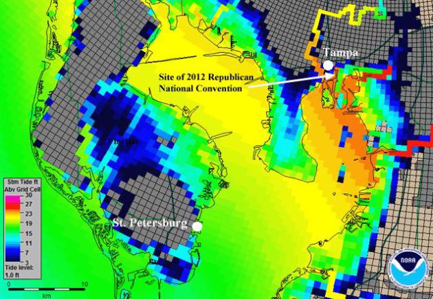
The Odds Of A Hurricane Spoiling The Republican National Convention In Tampa.
What are the odds? Not 'gonna happen, right? Right??? It's a long-shot,
but no, the probability is not zero. Here's an excerpt of a great post
from Dr. Jeff Masters at
Weather Underground: "
On September 25, 1848, the Great Gale of 1848,
the most violent hurricane in Tampa's history, roared ashore as a
Category 3 or 4 hurricane with 115 - 135 mph winds. Major R. D. S. Wade
weathered the storm in Fort Brooke,
in what is now downtown Tampa. Here is what he wrote this to his
commanding officer in Washington D.C.: "The waters rose to an
unprecedented height, and the waves swept away the wharves and all the
buildings that were near the Bay or river." A 15-foot storm surge was
observed at Fort Brooke, and the peninsula where St. Petersburg lies in
Pinellas County was inundated "at the waist" and "the bays met,"
making St. Petersburg an island. After the hurricane, "Tampa was a
scene of devastation."
Graphic credit above: "
Predicted
height above ground of the water from a worst-case Category 4
hurricane in the Tampa Bay region, as computed using NOAA's SLOSH storm
surge model. The Tampa Bay convention center would go under 20 feet of
water, and St. Petersburg would become an island, as occurred during
the 1848 hurricane."
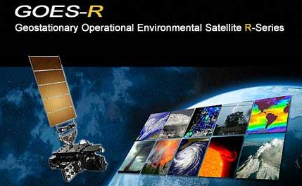
New Weather Satellites To Boost Hurricane Forecasting.
New technology is in the works to provide not only more accurate
hurricane predictions, but improvements in hyper-local severe weather
tracking and forecasting.
Techzone360.com and Sun Sentinel - McClatchy-Tribune Information Services via COMTEX has the story; here's an excerpt: "
In
the not-too distant future, you should have a much better idea of just
how strong an approaching hurricane might be -- as well as whether you
can expect to see wildfires, volcanic activity or routine rain showers
in your vicinity.
This is courtesy of GOES-R, a super sophisticated weather satellite that
should provide the National Hurricane Center and other U.S. weather
agencies a major forecasting boost by 2016. Hovering 22,000 miles above
Earth, it will be armed with a camera powerful enough to capture a
hurricane's core in intricate detail or the total amount of lightning
that zapped the United States on any given day. "If you sum it
all up, it's going to provide 30 times more data than what we're
getting from current satellites," said senior hurricane specialist Jack
Beven."
NOAA's GOES-R web site is
here.
"Ask Paul". Weather-related Q&A:
Dear Paul,
"I am planning a fall color viewing trip to Lake City and the surrounding countryside. Is October 12th, 13th, and 14th ok, or is it going to be too late for the peak?
Thanks Paul,
Scott Holler
Dalton Gear Co. Minneapolis
P.S. I was told “Ask Paul Douglas, he’ll know what is going on with this years fall color.”
Scott, based on my (fading) memory colors tend to
peak in the Twin Cities in mid-October. The Lake City area, down around
Lake Pepin, is usually a week later, roughly the third week of October.
But you should still see plenty of color between October 12-14,
especially between the Twin Cities, Hastings and Red Wing, on the drive
down to Lake City. Peak color depends on how much rain we receive
between now and October, and whether we get an early frost this year (no
idea). I think you'll be just fine in mid-October. Good luck!
Paul,
"What is dual polarization Doppler radar and why should I care?"
Andy Mair
Old NWS Doppler New "Dual Polarization" Doppler
Andy - the local NWS, along with every one of the
149 offices, is converting their Doppler over to "dual pol", short for
dual polarization. Basically it's a tune-up for the radar system,
hardware and software, that increases the sensitivity and functionality,
creating more useful high-resolution data sets for meteorologists. The
local NWS in Chanhassen just completed the upgrade (their radar is back
up!). Here are more details on what dual-pol can do, from the local NWS
web site:
* Better estimation of total precipitation amounts.
* Better estimation of the size distribution of hydrometeors (raindrops, snowflakes, hailstones, drizzle).
* Much improved ability to identify areas of extremely heavy rainfall that are closely linked with flash floods.
* Improved detection and mitigation of non-weather related radar echoes (chaff, smoke plumes, ground clutter).
* Easier identification of the melting layer (helpful for identifying snow levels in higher terrain).
* Improved ability to classify precipitation type.
** Note: Although the NWS didn't list this, it's
worth pointing out that dual polarization Doppler is so sensitive that,
in some cases, it should be able to detect the "debris ball" from a
tornado, the dirt, rubble and swirling garbage kicked up by a tornado
signature on the ground. Tornadoes are historically to small to show up
on radar - we see the spinning parent thunderstorm. But now we have
another tool to detect whether circulation is reaching the ground, and
in some (not all) cases this new capability may be able to confirm that
rotation is, in fact, producing an actual tornado on the ground. With
any luck, over time this may result in a lower false alarm rate for
tornadoes.
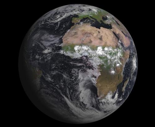
New ESA MSG-3 Weather Satellite Captures First Image.
I don't know about you, but I can't get enough imagery of Earth from
space - it still takes my breath away. Here's an excerpt of an article a
redorbit.com, focused on a new European weather satellite beaming back remarkable pictures of home: "
The
European Space Agency’s latest weather satellite has capture its first
image of the Earth, the agency said. The MSG-3 satellite captured the
first image using the Spinning Enhanced Visible and Infrared Imager
(SEVIRI) instrument. The satellite launched on July 5, and ESA
said it is performing well and on its way to taking over operational
service after six months of commissioning. ESA said it was responsible
for the initial operations of MSG-3 after launch, and handed over the
satellite to EUMETSAT on July 16. The geostationary weather satellite’s
first image was a joint achievement by ESA, EUMETSAT, and the European
space industry."
Image Credit: Eumetsat
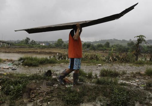
Philippine Forecasters Protest, Track New Storm.
I've never heard of this - meteorologists protesting? Manila has been
engulfed by record, historic floods in recent weeks. Here are more
details from AP and
The Atlanta Journal-Constitution: "
As
another storm threatened to cause more flooding, hundreds of
Philippines' weather agency employees protested over their pay Tuesday
and warned that forecasting services could deteriorate. An alarmed
President Benigno Aquino III rushed to assure the protesting employees
that steps were being taken to resume payment of the cash benefits that
had been suspended in March. "I just reminded that since the weather is
bad and we have a weather disturbance, we should not add to the
worries of those who were hit by the floods," Aquino told reporters
after a hasty meeting with the restive employees."
Photo credit above: "A
man carries part of his roof as he rebuilds his flood damaged home
along the riverbanks in suburban Marikina, east of Manila, Philippines
on Tuesday, Aug. 14, 2012. The government is still grappling with the
aftermath of a massive flooding when tropical storm Kai-Tak blew in
affecting the country's northeast." (AP Photo/Aaron Favila)
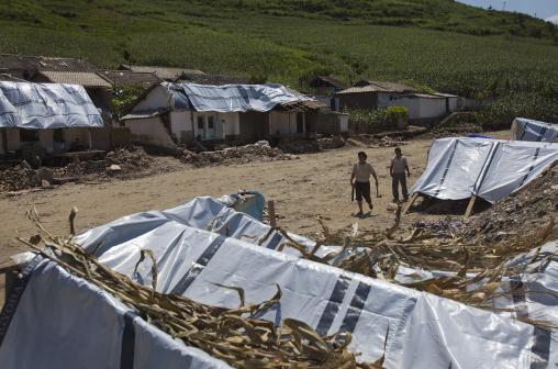
North Koreans Recount Terror When Flood Engulfed Hamlet. AP has some harrowing details: "
Tears
rolled down Ri Hyang Ran's cheeks as she recalled her terror the night
floods engulfed her farming-and-mining hamlet northeast of North
Korea's capital, Pyongyang. As the rain pounded down, town officials
went door to door hustling residents out of their homes in the middle
of the night. Still in her pajamas, Ri said she only had time to grab
two things: her portraits of North Korea's late leaders Kim Il Sung and
Kim Jong Il. Huddling with her neighbors in the mountains high above
the village, she could see nothing in the darkness but the sheets of
rain that pummeled Songchon county on the night of July 23. "But I
could hear the sound of walls collapsing, and it was terrifying," she
told The Associated Press on Monday, wiping her tears away with a
towel. When dawn broke, she discovered that her home for the past two
decades was gone, swept away by the torrent of water that tore through
this part of South Phyongan province."
Photo credit above: "Displaced
North Korean women, left homeless by July flooding, walk among
temporary tents set up in their destroyed neighborhood in Ungok, North
Korea on Monday, Aug. 13, 2012. Floods killed at least 169 North Koreans
nationwide and destroyed tens of thousands of homes." (AP Photo/David Guttenfelder)
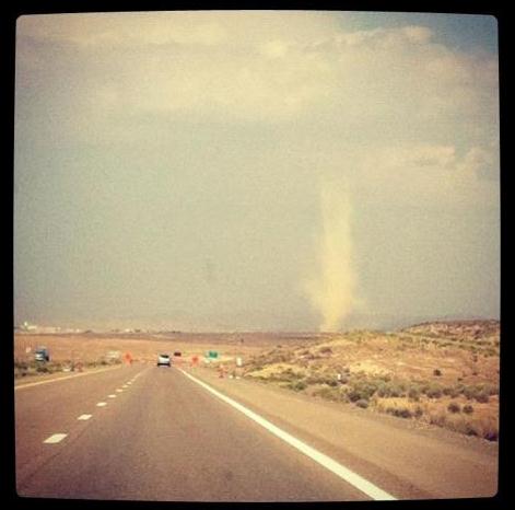
Dust Devil! Thanks to Scott Valbert, who snapped
this remarkable photo near Wendover Utah on Monday. Dust devils are
intense, rotating columns of air that can pick up dust and debris into a
tornado-like funnel. Unlike tornadoes, which get their spin from wind
shear, dust devils form as a result of extreme instability, super-heated
desert air near the ground creating a spinning vortex. Sun shining on
the dust devil gave it a whitish appearance.
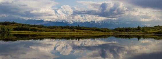
Postcard Perfect. Here's a terrific photo, courtesy of Denali National Park via
FB: "
As the fall colors start to roll in, Mount Mckinley makes an exclusive appearance by reflection pond."
Typical Mars Day: Bitter Cold, Pink Sky. Here's an excerpt of a fascinating article (and video clip) from
Florida Today: "
Manuel
de la Torre is a Mars-weather expert, and the forecast for Curiosity’s
landing site calls for clear skies now but dust storms in the
not-so-distant future. “We are expecting a clear day here on Mars with
thin ice clouds on the horizon,” he said, and “balmy, minus-20 degree
temperatures. But overnight, it might get chilly – all the way down to
minus-200 degrees Fahrenheit.” Winds are expected to be calm. Skies
should be pink. But the winter season on the red planet is coming to an
end. Spring and summer are bound to bring dust devils – swirling
columns of dust that look and act like tornadoes."
Photo credit above: "
Mars forecast: Clear skies, cold
temps: "Temperatures on Mars hover around 0 Fahrenheit during the day
and drop to as low as -200 at night." By Time Walters and Todd Halverson. August 9, 2012.
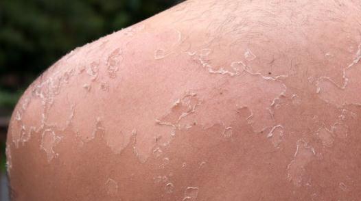
New Monitoring Wristband Tells Users When To Get Out Of The Sun.
Here's a good idea, factoring in the escalating cases of melanoma. I
love the sun as much as the next person - but it would be helpfuly to
know when I'm getting too much UV radiation.
Gizmag.com has more details: "
With
around 200,000 new cases worldwide of malignant melanoma, the most
virulent form of skin cancer, reported in 2008 according to Cancer
Research UK statistics, limiting exposure to the sun is vitally
important. But keeping track of our exposure, particularly on cloudy
days, can be a difficult exercise. New technology developed at the
University of Strathclyde makes things easier by providing a visual
warning of when to seek some shade or slap on some more sunscreen."
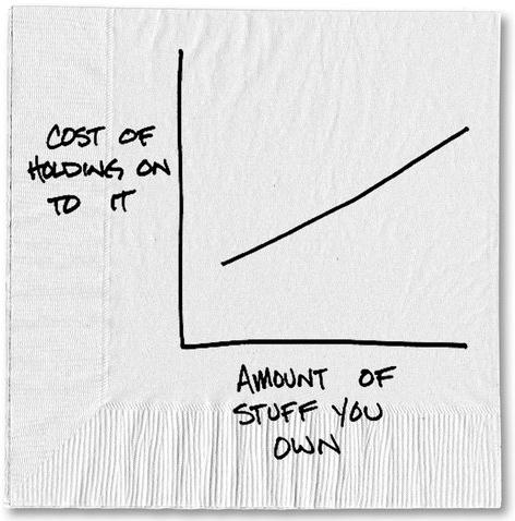
You Probably Have Too Much Stuff. Don't get me
started on this topic. We have a small warehouse full of (crap) from 4
moves, sentimental stuff mixed in with stuff I'm convinced we'll never
use or need again. "But the kids may want some of this!" my wife pleads.
Uh huh. I don't think so, but as only someone who has been married for
28 (blissful) years can relate: you have to pick your battles. That's
why this post (which my dear wife e-mailed me) from Carl Richards at
The New York Times rang true; here's an excerpt: "
When a man named Andrew Hyde began an adventure in minimalism, he only owned 15 things.
It eventually moved to 39 and now it sits around 60. It all started
when he decided to take a trip around the world and sell everything he
didn’t need. As Mr. Hyde noted on his blog, it changed his life after a
brief period of befuddlement:
I’m so confused by this. When we were growing up, didn’t we all
have the goal of a huge house full of things? I found a far more
quality life by rejecting things as a gauge of success.
When I came across his original story of only owning 15 items, I
was so inspired I immediately went home and found 15 things to give
away. Most of these things were clothes that I had long since stopped
wearing, but I held on them because . . . well, just because. In fact I
have no idea why I still had a tie I hadn’t worn in four years or a
shirt that no longer fit."
Illustration above: Carl Richards, The New York Times.
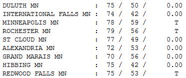
Cloudier Than Expected. We got off to a nice, sunny
start, but clouds swept in by afternoon, reports of a few light
sprinkles. Highs were a few degrees cooler than average yesterday,
ranging from 70 at Grand Marais to 77 St. Cloud, 78 in the Twin Cities,
and 79 at Rochester.
Paul's Conservation Minnesota Outlook for the Twin Cities and all of Minnesota:
TODAY: Intervals of warm sun, more humid.
T-storms likely; a few may be severe. Winds: S: 10-20. Dew point: 62.
High: 87 (if the sun stays out for a few hours 90 isn't out of the
question).
WEDNESDAY NIGHT: Heavy thunderstorms likely. Low: 60
THURSDAY: Damp start. Clearing skies, windy and much cooler. Winds: NW 15-30. Dew point: 48. High: 73
FRIDAY: Bright sun, less wind. Dew point: 42. Low: 54. High: 72
FRIDAY NIGHT: Clear and comfortably cool. Low: 55 (some 40s up north).
SATURDAY: More clouds than sun, lukewarm. Winds: NW 5-10. High: 74
SUNDAY: More sun, a bit milder. Dew point: 51. Low: 57. High: 77
MONDAY: Warm sun. Like every other Monday. Low: 60. High: 82
TUESDAY: Sunny. Feels like summer again. Low: 64. High: 85
Highs may approach or top 90 the latter half of next week.
Free Lawn Watering
Good news: no sign of oppressive heat returning
anytime soon. For the better part of 7 weeks we sizzled, fried and
sweated our way through historic heat. But shorter days and a lower sun
angle has (finally) enabled cooler air of Canadian heritage to push
south. Not only does this mean a welcome dip in temperature & the
dreaded dew point, but it sets the stage for more airmass scuffles,
frontal passages sparking more significant rain events. The sad truth:
any rain may come much too late for many farmers. The damage has been
done.
One small silver lining to the heat/drought: we
haven't had enough wind shear to spin up tornadic T-storms. Intense heat
has shoved the battleground north. Last month Saskatchewan, Canada saw
more tornadoes than the entire USA (only 24 twisters touched down in
July).
Strange.
More T-storms arrive today; a few may be severe,
with hail and damaging winds. The next push (more like a shove) of cool
air arrives Thursday, on stiff northwest winds. High pressure keeps us
sunny Friday; weather should be "good enough" for the lake or cabin this
weekend; 70s under a partly sunny sky.
But don't write off summer heat just yet. A few 90s return again next week.
Climate Stories....
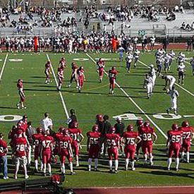
Is Climate Change Making Temperatures Too Hot For High School Football?
Uh oh, when a warming climate starts to impact football, watch out.
It's a real and growing concern, especially over the southern USA, as
reported in
Scientific American; here's an excerpt: "...
Scaling
back the intensity of a football practice due to hot weather was once
laughable in South Georgia, where heat, gnats and hard-hitting high
school football are facts of life. But this year Georgia became the
latest state to enact new rules
to prevent heat-related deaths of high school football players, a
category in which the state leads the nation. "The climate's getting
warmer so players are exposed to higher temperatures," said Andrew
Grundstein, a climatologist at the University of Georgia and a
co-author of a 2012 study of heat related deaths in high schools nationwide. Across
the country, deaths of high school football players due to heat nearly
tripled from 1994 to 2009 compared to the previous 15 years, according
to Grundstein's study. Heat illnesses in football players
have multiple causes, experts say, but as the climate heats up,
practices in Georgia – and around the country – are getting watered
down just to be safe."
Photo credit above: "
Wikimedia Commons/xnatedawgx."
States Work To Protect High School Football Players From Extreme Heat Risk. Here's an excerpt of a story from UCS,
The Union of Concerned Scientists: "
Scientists
Conclude Risks Are Increasing as Climate Change Drives More Extreme
Heat, Athletes More Likely to be Obese. Last year, several high school
football players died from exhaustive heat stress, a trend that is,
unfortunately, increasing over time. Since 2006, at least 20 high school football players have died
from exertional heat stroke according to the University of North
Carolina’s National Center for Catastrophic Sport Injury Research. At a press conference last year
convened by the Union of Concerned Scientists, researchers concluded
that a combination of increased extreme heat due to climate change and
rising childhood obesity can prove lethal for high school football
players. Both extreme heat and high humidity can put players at risk."
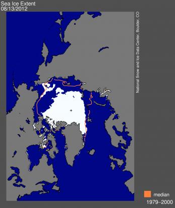
A Summer Storm In The Arctic. A recent cyclone/storm, far more intense than usual, may have helped to break up ice in the Arctic, as reported by the
National Snow and Ice Data Center; here's an excerpt: "
Arctic
sea ice extent during the first two weeks of August continued to track
below 2007 record low daily ice extents. As of August 13, ice extent
was already among the four lowest summer minimum extents in the
satellite record, with about five weeks still remaining in the melt
season. Sea ice extent dropped rapidly between August 4 and August 8.
While this drop coincided with an intense storm over the central Arctic
Ocean, it is unclear if the storm prompted the rapid ice loss. Overall,
weather patterns in the Arctic Ocean through the summer of 2012 have
been a mixed bag, with no consistent pattern."
Graphic credit above: "
Arctic sea ice extent for August
13, 2012 was 4.90 million square kilometers (1.9 million square miles),
450,000 square kilometers (173,745 square miles) below the same day in
2007. The orange line shows the 1979 to 2000 median extent for that
month. The black cross indicates the geographic North Pole."
Sea Ice Index data.
About the data. Credit: National Snow and Ice Data Center
Do Paul Ryan And Mitt Romney Disagree On Climate Change? I
hope, at some point, there is an acknowledgment of the science in the
weeks and months ahead, on both sides of the political aisle. Here's an
excerpt from a story at The Washington Post's
Wonkblog: "
Mitt
Romney’s views on climate change can be difficult to pin down. In
2004, when Romney was governor of Massachusetts, his administration
unveiled a detailed plan to reduce the state’s carbon emissions. As recently as June 2011, Romney was telling voters
in New Hampshire that “the world’s getting warmer,” that “I believe
that humans contribute,” and that “I think it’s important for us to
reduce our emissions of pollutants and greenhouse gases.” Since then,
however, Romney has softened that stance somewhat. “I don’t know if
[rising temperatures are] mostly caused by humans,” he told another New Hampshire crowd last summer. “What I’m not willing to do is spend trillions of dollars on something I don’t know the answer to.”
Photo credit above: AP.
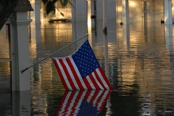
What Country Faces The Worst Climate Change? Here's a snippet from a very interesting article at
Live Science: "
Rising
seas threaten to drown island countries such as the Maldives and
Kiribati in the era of global warming — a dire scenario that has forced
leaders to plan for floating cities or consider moving their entire
populations to neighboring countries. Most countries won't need to take
such drastic steps to simply survive, but many more will similarly
experience the uglier side of climate change. The countries potentially
facing the worst fates may not necessarily experience the greatest
climate change, but instead lack the resources to cushion their people
against climate-related disasters such as hurricanes, floods, heat waves
and droughts. That has historically made a huge difference in rates of
death or displacement from such events — Hurricane Jeanne killed just
three people in the U.S. in 2004, but resulted in the deaths of more
than 1,500 people in Haiti and displaced about 200,000 Haitians."
Photo credit above: "
A submerged American flag shows the devastation of a flood in downtown Cedar Rapids, Iowa, June 13, 2008." Credit: U.S. Air Force, Staff Sgt. Oscar M. Sanchez-Alvarez.
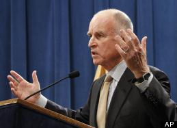
Jerry Brown Global Warming Web Site Takes On Climate Change Deniers.
The Governor of California is madder than hell (about climate change
deniers) and he isn't going to take it anymore. Here's an excerpt of a
Huffington Post story: "...
The site is called Climate Change: Just the Facts
and is operated by the Governor's Office of Planning & Research.
It gives a basic description of the science behind global warming,
shows the scientific consensus behind global warming science and
directly takes on common arguments made by people who question climate
change. While not every move made by the Governor is beloved by environmentalists,
Brown has a very long history of having a very short temper when it
comes people arguing against the existence of global warming. "The main
thing we have to deal with in climate change is skepticism and denial,
and the cult-like behavior of political lemmings that would take us
over the cliff," Brown said at an event he co-hosted with former
California Governor Arnold Schwarzenegger last year. "[There are
powerful wealthy forces] that want to crush any effort to cope with climate change." (Photo: AP).
Climate Change - Just The Facts. More on Gov. Brown's web site focused on climate change denial from
mydesert.com: "
Gov. Jerry Brown today has launched a new website — Climate Change: Just the facts –
that, as its name suggests, is aimed at providing California residents
with concise facts on the science of climate change and talking points for dealing with climate change skeptics.
And it doesn’t mince words:
The fact is that on the key issues,
the science is clear: climate change is real and happening now;
human-made greenhouse gas emissions are affecting our planet; and we
need to take action. Just as we reached a point where we stopped
debating whether cigarette smoke causes cancer, we need to end the
climate change debate and focus on how to solve the problem.
Maybe I’ve read too much on this already, but it seems to me the
website, while obviously well intended, is a bit simplistic and brief
in its explanations of climate change. Where it gets into specifics is
on the page of talking points for dealing with climate change skeptics..."


No comments:
Post a Comment