79 F. high in the Twin Cities Friday.
82 F. average high for August 10.
81 F. high on August 10, 2011.
Today: nicer, sunnier (drier) day of the weekend.
90 F. possible next Wednesday, followed by a 20-25
degree temperature free-fall; highs may hold in the 60s next Thursday
and Friday, temperatures mellowing out again by next weekend. Details
below.
Temperature Roller Coaster. "Mom, Paul's showing
that crazy model again, the one with high temperatures in Celsius! Why
does he do that?" O.K. This is the European model, the ECMWF, which I've
been using (heavily) since early in 2012. Why? Because it's doing a
consistently better job with Days 3-7 than the U.S. GFS model. It's not
perfect, but it does seem to be consistently better. Why? The ECMWF
handles initialization differently than the U.S. models, continuously
updating the model as new data arrives from various sources, surface
stations, satellites, weather balloons, etc. By comparison the U.S.
models initialize a few times/daily. This may be one (of many) reasons
why the ECMWF is doing better - not sure. Believe me, I wish the U.S.
models were performing better, but I'm trying to share not only the
thinking behind the forecast, but some of the best links, and rationale
for the forecast below. Sunday will be partly-soggy, we may have trouble
reaching 70. We warm up next week - 90 by Wednesday, followed by a BIG
cool frontal passage -
daytime temperatures may hold in the 60s next Thursday and Friday.
Have no fear; the sun is too high in the sky for it to stay chilly for
long. Low to mid 70s return next Saturday, topping 80 next Sunday.
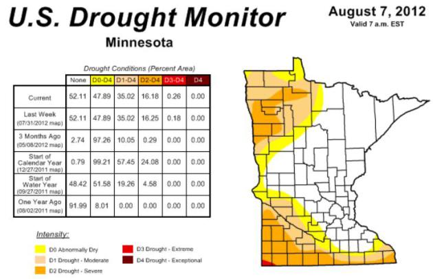
28 Minnesota counties currently in severe drought.
78.14% of the USA is described as "abnormally dry".
24.14% of America is in extreme or exceptional drought, nearly a quarter of the Lower 48 States.
16.18% of Minnesota in severe drought, down slightly from 16.25% last week.
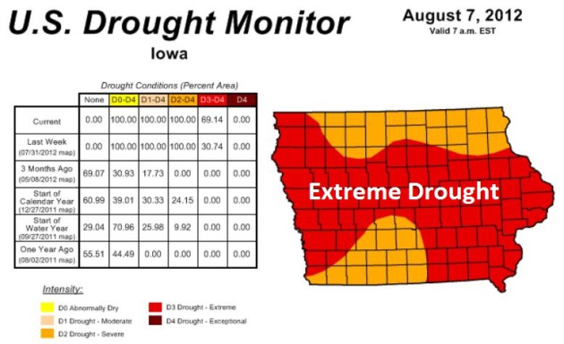
69.14% of Iowa in extreme drought, up from 30.74% last week.
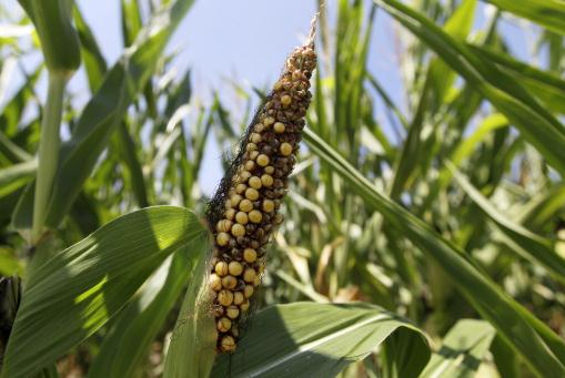
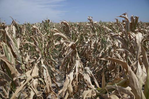
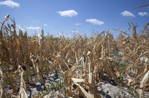
Photo credit above: "
This photo from Aug. 1, 2012, shows a
drought damaged ear of corn in Westfield, Ind., corn field. U.S. corn
growers could have their worst crop in a generation as the harshest
drought in decades takes its toll, the government reported Friday, Aug.
10, 2012, as it forecast the lowest average yield in 17 years." (AP Photo/Michael Conroy, File)
"A total of 12 to 17 tropical storms were expected to form
through the season overall, with as many as five to eight hurricanes,
forecasters said. Two to three of those could become major hurricanes,
which have top winds of 111 mph or higher." - from a story at khou.com in Houston; details below.
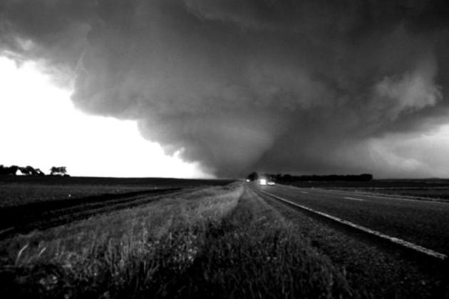
24 tornadoes nationwide in July (due to the drought and extreme heat). File photo: WNTV meteorologist Aaron Shaffer.
30 tornadoes reported in Saskatchewan, Canada last
month, according to Climate Central. Yes, the heat and drought has
shifted tornado alley north, into Canada, this summer.
46% record high CEI Index (Climate Extreme Index)
for 2012, to date, surpassing the previous record of 42% in 1934.
Details from NOAA NCDC below. Photo: WeatherNation TV meteorologist
Bryan Karrick.
El Nino conditions "likely to develop during August or September 2012", according to NOAA. Details below.
"
Nearly half of the nation’s corn crop is in poor or very poor
condition, as well as a third of soybeans. The damage would be much
worse without the crop science advancements of the last 40 years, said
Andrew Wood, a professor of plant physiology and molecular biology at
Southern Illinois University." - from a Washington Post article, details below. Photo credit: Nati Harnik, AP.
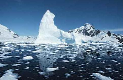
Less Arctic Ice Than 2007? Unusually warm weather is
creeping into the Arctic, where ice loss is on pace with the previous
record, 2007. Not only the aerial extent of ice but the volume of ice is
dropping rapidly; details below.
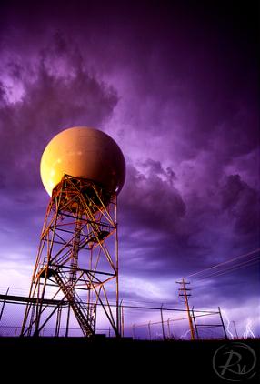
Twin Cities NWS Doppler Is Down For Maintenance. Actually, it's more than that - KMPX is being upgraded to "
dual polarization"
capabilities, a software and hardware upgrade that will help local
meteorologists predict everything from rainfall amounts, to winter
precipitation, even detect tornado signatures ("debris balls") with
greater accuracy. I'm holding my breath that there won't be any severe
weather outbreaks (doubtful) in the next week; until then we'll rely on
Doppler from Duluth, Sioux Falls and La Crosse. Photo above: Reid
Wolcott.
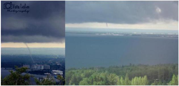
Thursday Waterspouts In Duluth. Check out the
remarkable photos of the waterspout that formed over Lake Superior, just
off the shoreline of Duluth. Photo upper left courtesy of Vana Leslee
Photography (via
WDIO). Photo upper left from Alissa Glickstein. Nicely done.
Agricultural Impact Of Drought. Dr. Mark Seeley had an interesting perspective and more timely facts about Minnesota's drought in this week's version of
WeatherTalk; here's an excerpt:
- Severe drought prevails in 28 Minnesota counties, yet just 16
percent of the corn crop is in poor to very poor condition, and just 13
percent of soybeans, relatively small percentages when compared to the
crop conditions in so many other states (IL, IA, MO, IN)
- Drought has pushed major commodity prices high (corn $8.29/bu,
soybean $16.31/bu) and they may go higher yet. This may lead to higher
food prices and higher costs for livestock feeding as the supply chain
in these crops is suppressed by lower yield estimates.
- Congress left for recess with many pieces of legislation unsettled,
including the new Farm Bill and other agricultural legislation.
Minnesota Drought: Holding Steady. There was little
change in the drought status, statewide, in the last week; 47% of
Minnesota "abnormally dry", over a third of the state in a moderate
drought, 16% in severe drought, and a tiny sliver of far southwestern MN
in an extreme drought (near Worthington). Soil moisture from Rochester
and Mankato, north to the Twin Cities, St. Cloud and Duluth are in good
shape. More details from NOAA's
U.S. Drought Monitor.
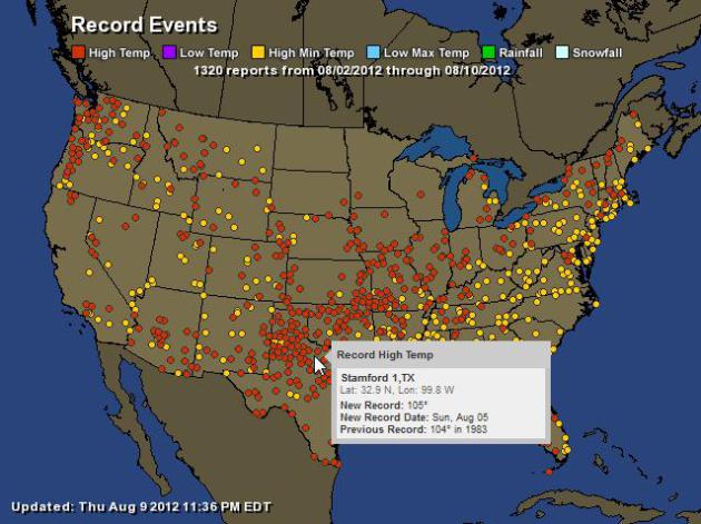
A Sprawling Heat Wave. Although the Upper Midwest
has seen significant relief, much of America continues to sizzle: 1,320
warm weather records since August 2, according to NOAA. Map courtesy of
Ham Weather.
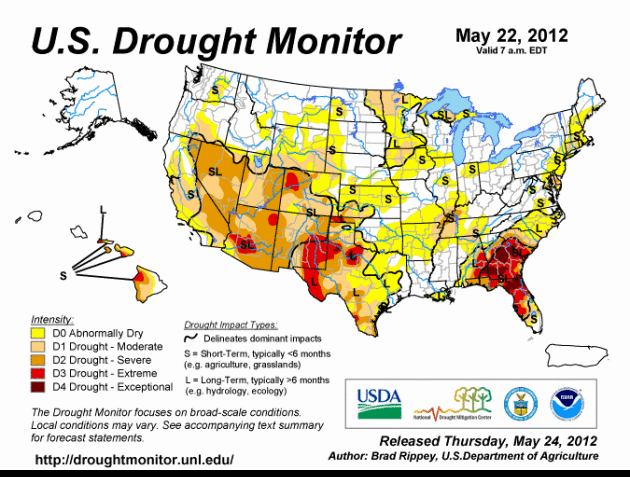
A Sprawling Drought. An estimated 62.46% of the USA
is in moderate drought (or worse). The worst conditions can be found
from southern Indiana westward through Missouri and Arkansas into Kansas
and Oklahoma, pockets of exceptional drought as far south as Georgia.
More details from the
U.S. Drought Monitor.
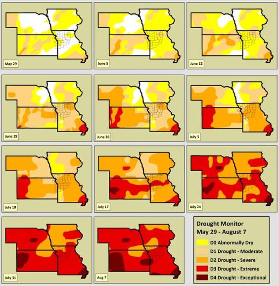
Drought Animation. You can see the progression of
the Great Drought of '12 since May 22 in this animation. The darker the
red: the more severe the drought - thought to be the worst since 1956,
possibly 1936.
Iowa Farmers Are In Trouble. At first I thought it
was a typo - I had to go back and check it again. The percentage of Iowa
in extreme drought jumped from 30.74% last week to 69.14% this week, a
nearly 40% jump. I've never seen that before. Details
here.
Evolution Of Drought. The steady spread of drought conditions since May 29 has been striking; more details from
NOAA: "
The
latest drought monitor is now available in the region. Once again,
extreme drought continues over much of Kansas and Missouri. However,
portions of the area have now been upgraded to the highest level of
drought, “exceptional”. The drought monitor does not include impacts of
rainfall from last night, but given the scattered nature of rain, the
improvements would be minimal. Since the beginning of the drought
monitor in 1999, this is the first “exceptional” drought status in
western Missouri."
Severe Losses For Reinsurers From U.S. Drought: Munich Re.
CNBC.com has the details; here's an excerpt: "
The
recent dry weather affecting crops across the midwest of America will
hit the reinsurance industry with perhaps the biggest loss ever,
according to Nikolaus von Bomhard, Chairman at Munich Re. “We do think
it will be severe and probably one of the severest losses for this
market ever,” he told CNBC Wednesday. “It’s too early to tell what the
exact claim will be because we have to wait until the harvest is done.”
The prolonged hot spell is said to be the worst in five decades and has damaged corn production across 26 U.S. states."
Photo credit above: "
A dry field of corn is seen near
Ashland, Neb., Thursday, Aug. 9, 2012. The latest U.S. drought map
shows that excessively dry conditions continue to worsen in the Midwest
states that are key producers of corn and soybeans. This is the worst
U.S. drought in decades. The weekly U.S. Drought Monitor map released
Thursday, Aug. 9. 2012 shows that the area gripped by extreme or
exceptional drought rose nearly 2 percent to 24.14 percent." (AP Photo/Nati Harnik)
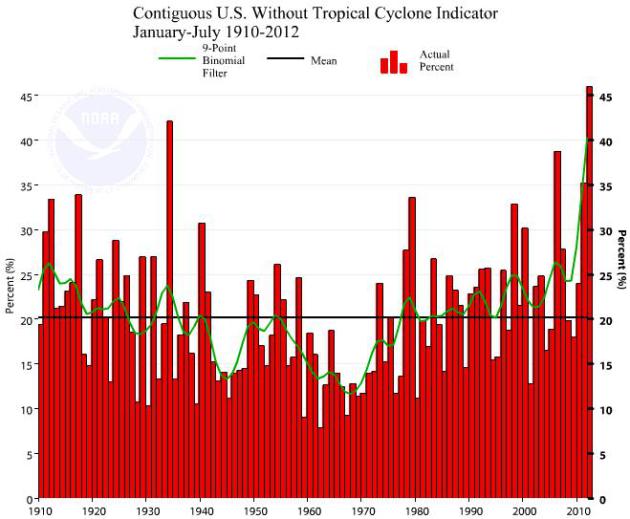
2012: Most Climate Extremes On Record. Here's an explanation from NOAA: "
The
U.S. Climate Extremes Index (USCEI), an index that tracks the highest
and lowest 10 percent of extremes in temperature, precipitation, drought
and tropical cyclones across the contiguous U.S., was a record large 46
percent during the January - July period, over twice the average value,
and surpassing the previous record large CEI of 42 percent, which
occurred in 1934. Extremes in warm daytime temperatures (83 percent) and
warm nighttime temperatures (74 percent) both covered record large
areas of the nation, contributing to the record high year-to-date USCEI
value." Graph courtesy of
NOAA NCDC.
WRF Solution. NOAA's WRF model shows heavy showers
and T-storms at 1 pm today along the east coast today, wrapping around
into the Great Lakes - more T-storms over the Dakotas and Rockies. By
Sunday light to moderate showers push into portions of MInnesota and
Iowa, the east coast dries out; showers and T-storms lingering over
Florida.
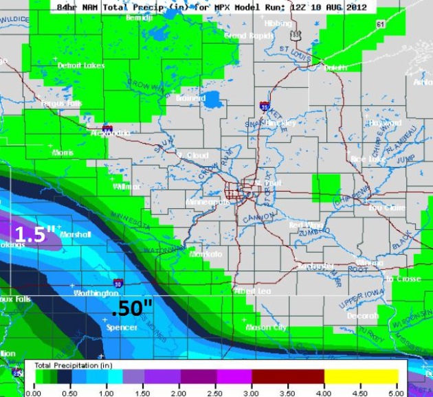
Dueling Models. The NAM solution (above) keeps
Saturday night/Sunday showers over far southwestern Minnesota, while the
ECMWF spreads showers into the Twin Cities metro and St. Cloud by
Sunday. I'm going with the European run, erring on the side of caution.
Certainly the best chance of rain Sunday will come south/west of the
metro area.
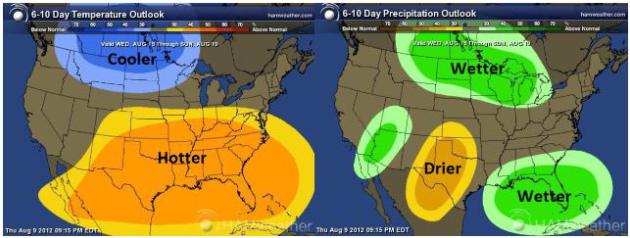
First Hints Of Autumn. Remarkable news: we may enjoy
a spell of cooler, wetter than normal weather as we sail into
mid-August. NOAA's Climate Prediction Center 6-10 Day Outlook shows a
cool, wet bias for the Northern Plains and Upper Midwest - more
relentless heat for the southern half of America. Map:
Ham Weather.
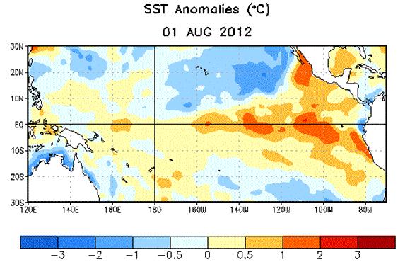
NOAA: "El Nino Conditions Likely To Develop During August Or September 2012". More details from
NOAA NCEP: "
ENSO-neutral
conditions continued during July 2012, despite above-average sea
surface temperatures (SST) across the eastern Pacific Ocean. Reflecting
this warmth, most of the weekly Nino index values remained near or
greater than +.5 C. The oceanic heat content anomalies (average
temperatures in the upper 300 meters of the ocean) also remained
elevated during the month, consistent with a large region of
above-average temperatures at depth across the equatorial Pacific.
Althugh sub-surface and surface temperatures were above average, many
aspects of the tropical atmosphere were inconsistent with El Nino
conditions."
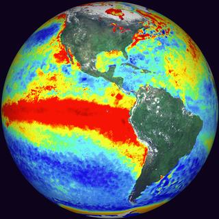
Graphic credit above: "
Average sea surface temperature
(SST) anomalies (C) for the week centered on 1 August, 2012. Anomalies
are computed with respect to the 1981-2010 base period weekly means."
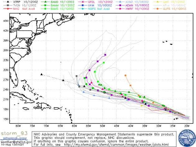
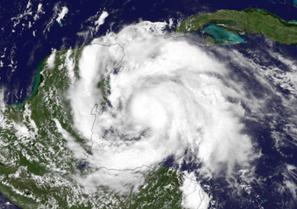
Hurricane Havoc: Forecasters Raise Outlook. Yes, NHC
is going out on a limb, but things do seem to be more active in the
Atlantic - we're tracking a number of tropical depressions that could
mutate into tropical storms and hurricanes next week. Details from a
story at
KHOU.com in Houston: "
An
Atlantic hurricane season that got an early start is likely to stay
busy and may produce a few more storms than originally predicted, U.S.
forecasters said Thursday. The updated forecast for the season that runs
from June 1 to Nov. 30 says there are dueling weather conditions that
could also tamp down activity later in the six-month stretch. A total
of 12 to 17 tropical storms were expected to form through the season
overall, with as many as five to eight hurricanes, forecasters said.
Two to three of those could become major hurricanes, which have top
winds of 111 mph or higher. So far this year there have been four
tropical storms and two hurricanes. One of those — Ernesto — made
landfall late Tuesday as a Category 1 hurricane on Mexico’s Caribbean
coast near its border with Belize." (Graphic above can be found
here).
NOAA Raises Hurricane Season Prediction Despite Expected El Nino.
The forecast calls for El Nino by autumn (see above). El Nino patterns
usually imply stronger winds over the tropics - conditions not favorable
for hurricane development (those winds tend to shred developing
tropical storms and prevent them from reaching their peak potential). In
spite of this,
NOAA NHC is predicting a higher than average number of tropical systems: "
This
year’s Atlantic hurricane season got off to a busy start, with 6
named storms to date, and may have a busy second half, according to
the updated hurricane season outlook issued today by NOAA’s Climate
Prediction Center, a division of the National Weather Service. The
updated outlook still indicates a 50 percent chance of a near-normal
season, but increases the chance of an above-normal season to 35
percent and decreases the chance of a below-normal season to only 15
percent from the initial outlook issued in May.
Across the entire Atlantic Basin for the season – June 1 to
November 30 – NOAA’s updated seasonal outlook projects a total (which
includes the activity-to-date of tropical storms Alberto, Beryl,
Debbie, Florence and hurricanes Chris and Ernesto) of:
- 12 to 17 named storms (top winds of 39 mph or higher), including:
- 5 to 8 hurricanes (top winds of 74 mph or higher), of which:
- 2 to 3 could be major hurricanes (Category 3, 4 or 5; winds of at least 111 mph)
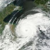
Photo credit above: "
Satellite image of Hurricane Ernesto taken on Aug. 7, 2012 in the Gulf of Mexico." (Credit: NOAA)
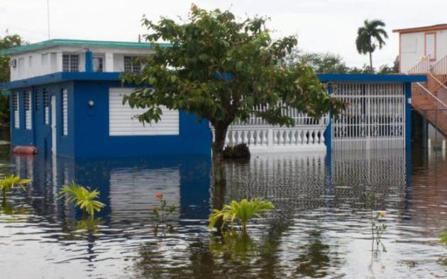
Get Flood Insurance Before You Need It. Are you in a flood zone? When was the last time you checked? Here's an excerpt of an important article from
Reuters: "
The
best time to get protection against a flood is before it happens. That
means if you keep anything in a basement or live on the ground floor,
it's important to have flood insurance. Floods are the most common natural disaster and they can cause significant damage.
Buying flood insurance is always a good idea but in some cases it's
also mandatory. It's important to understand how and when to buy flood
insurance so that you're prepared before disaster strikes.
The Federal Emergency Management Agency administers the National Flood
Insurance Program which is generally a good place to start.
Under federal law, homes with a federally regulated mortgage must have
flood insurance if located within a Special Flood Hazard Area. Even if
your home is not within a SFHA, banks may require that you have flood
insurance before approving a mortgage." Photo credit: NOAA.
"Ask Paul". Weather related questions, comments, taunts and threats:
Hi Paul,
"
There is a difference between the NOAA temperature of 77.6 F.
for July 2012 and the temperature of 75.5 F. which results if you use
the new Climate Reference Network (USCRN); this reading is 2.1 degrees
F. cooler, and means that July 2012 was not really a record high. Please
address this difference in your daily Star Tribune weather forecast.
My very regards and appreciation for your efforts at educating the public in the arcane art of climate."
James Durant
James - thanks for the e-mail. From what I understand of the new
(USCRN) climate observing network, it's only been around since 2007, so
there's no long database of data to compare the numbers with, at least
not yet. I posed your question to local climate science guru Dr. John
Abraham, at St. Thomas. Here is his response:
"
USCRN data cannot be used for long-term comparisons because it
wasn't around a decade ago. So using it to compare today's temperatures
to early temperatures is an apples to oranges comparison."
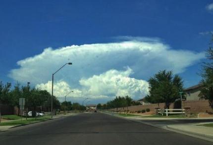
Mushroom Cloud. Thanks to @bryansnider who snapped this photo of a towering cumulonimbus near Maricopa, Arizona. Spectacular.
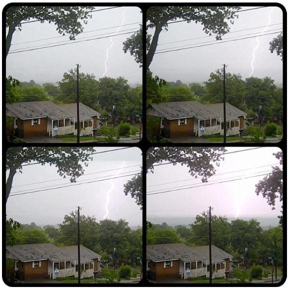
Lightning Time Lapse. Matt Beach took a series of high-speed photos of a cloud to ground lightning strike near Chattanooga, Tennessee yesterday.
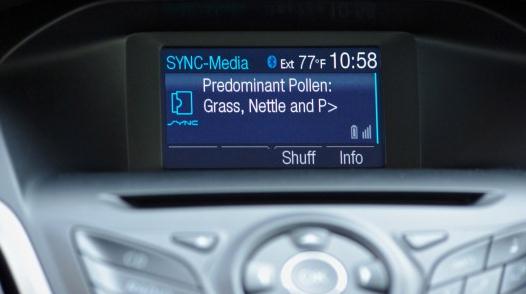
Allergy Updates - In Your New Ford? The "connected
vehicle" is an exciting concept, but I worry about information overload
when I'm navigating traffic on 494 at rush hour. I worry about
allergies, but I'm worried about that guy in the semi. Details from
gizmag.com: "
Seasonal
allergies strike 20 percent of Americans every year. Some people
suffer so badly that they check the pollen count with the devotion that
others pay to the stock market. For some asthma sufferers, an allergy
attack can even lead to a life-threatening asthma episode. As part of
its program to help motorist manage their health, Ford has announced
that cars equipped with its SYNC AppLink system will be able to alert drivers about pollen and other health-related conditions."
500 Most-Visited Web Sites. The story (and slide show) from
Huffington Post; here's an excerpt: "
Is
there a website that you can't go a day without checking? Chances are,
a few million other people have the same favorite, if web data company
Alexa's list of the world's 500 most popular sites
is any indication. Alexa's web stats are updated daily, but its ranking
system relies on three months worth of information. The rankings
consist of several different criteria including a website's global
reach and number of pageviews. "Alexa computes traffic rankings by
analyzing the Web usage of millions of Alexa Toolbar users and data
obtained from other, diverse traffic data sources," the company's site reads."
How To Make Your Lost Phone Findable. The New York
Time's David Pogue had quite an adventure last week; he lost his phone,
and using Twitter (and local police) was able to track it down. But it
got him thinking; what technology or apps can I utilize to find my
phone, if and when it gets lost again? Here's an excerpt from his column
at
The New York Times: "
Last
week, I lost my iPhone on a train. I used Apple’s Find My iPhone
feature to track it to a house in suburban Maryland, and the local
police were able to return it to me. Because I’d tweeted about these
developments, the quest for the phone became, much to my surprise, an
Internet-wide, minute-by-minute real-life thriller. (You can read the
whole story here.)
Several readers wrote to ask how to set up their own phones to be
findable. As you’d guess, given last week’s experience, I have some
strong feelings about the importance of setting up Find My iPhone or the
equivalent on Android phones."
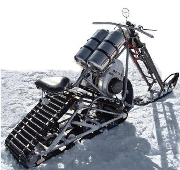
Snow Chopper. Looks like a "Snow Hog" to me - very cool. Details from
Neatorama.com: "
Weather
is no obstacle or excuse for the committed motorcyclist--even the
extremes of Antarctic weather. That's why Bob Sawicki and Toby Weisser,
two mechanics at McMurdo Station in Antarctica, built this
chopper-style snowmobile from scraps four years ago: “This is what
McMurdo is throwing away,” Sawicki proudly pointed out to a visitor
gawking at the heavy-framed snowmobile. The brake is a bent crowbar,
the accelerator handle an old tent pin. Pre-bent pipes found in a waste
metal recycle bin worked perfectly in shaping the frame."
Ford Pushes Speed And Economy Rating Of 2013 C-MAX Hybrids. This new car from Ford caught my eye; a potential Prius-killer?
Gizmag.com has details: "
Ford definitely appears to have Toyota in its sights with its 2013 C-MAX line. Having already revealed the C-MAX Hybrid will be cheaper than Toyota’s Prius v,
the U.S. automaker is now boasting that its hybrid utility vehicle
beats the Prius v in the fuel economy stakes by up to 7 mpg (2.9 km/l).
It is also the first vehicle to offer the same fuel economy rating in
both city and highway driving."
My Favorite Olympic Event. Yes, Pee Wee got the Gold Medal, a glorious moment for the United States. THanks to Joshua Hauser and
Facebook for the chuckle.
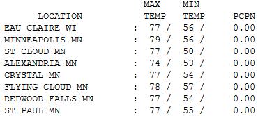
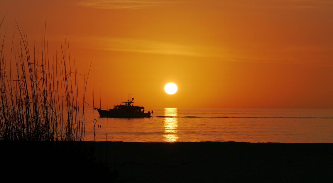
Perfect Friday. Could it have been any nicer out
there yesterday? I don't think so. Under a postcard-perfect sky highs
ranged from 74 at Alexandria to
77 St. Cloud, 79 in the Twin Cities.
Paul's Conservation Minnesota Outlook for the Twin Cities and all of Minnesota:
TODAY: Better day of the weekend. Blue sky, low humidity. Dew point: 48. Winds: SE 3-8. High: 77
SATURDAY NIGHT: Clouds increase, chance of shower late. Low: 58
SUNDAY: Cloudier and cooler, chance of a few showers. Best chance of rain south/west of MSP. Dew point: 55. Winds: SE 10. High: 72
MONDAY: Partly sunny. Feels like summer again. Dew point: 59. Low: 57. High: 82
TUESDAY: Some sun, sticky. Dew point: 64. Low: 62. High: 86
WEDNESDAY: Warmest day. PM storms? Dew point: 67. Low: 65. High: near 90
THURSDAY: Windy, much cooler with showers. DP: 54. Low: 60. High: 68
FRIDAY: Sweatshirt weather? Brisk! More clouds than sun, still windy. Dew point: 43. Low: 53. High: 64
Highs should top 70 next Saturday, possibly topping 80 by Sunday of next week.
iOverload
Every day I feel like I'm swimming (flailing)
upstream, fighting a tidal wave of e-mails, tweets, links - trying not
to drown in the detritus of Digital Overload.
Yesterday someone in Korea tried to hack my Facebook account.
Why? Great question. There's nothing that valuable on my Facebook page, I can assure you.
We're all connected, but the jury is out on whether that's a good thing.
Growing up I'd drive 30 miles to a local
community college to check the NAFAX weather maps. Today: thousands of
weather sites and dozens of weather apps at the press of a button,
sitting at home in my underwear. Sorry for that visual.
Will the need for meteorologists go the way of
Betamax tapes and manual typewriters? I hope not. Finding nuggets of
wisdom in a flood of raw data will always add value; providing analysis,
context and perspective. Tell me a story. Why should I care? Then again, I could just be delusional.
28 Minnesota counties are in severe drought so I
won't whine about a few Sunday showers. Today will be the sunnier,
better day for the lake.
We warm up next week; near 90 Wednesday before a
big midweek "correction". The coolest front since late May has us
reaching for sweatshirts by Friday; highs in the 50s & 60s.
The worst of the heat and humidity is behind us now. My gut reaction: good riddance!
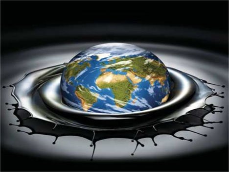
Climate Stories...
"Global Warming Is Here To Stay." From The Washington Post Writers Group, via
The Orlando Sentinel: "
WASHINGTON
-- Excuse me, folks, but the weather is trying to tell us something.
Listen carefully, and you can almost hear a parched, raspy voice
whispering, "What part of 'hottest month ever' do you people not
understand?" According to the National Oceanic and Atmospheric Administration,
July was indeed the hottest month in the contiguous United States
since record-keeping began more than a century ago. That distinction
was previously held by July 1936, which came at the height of the Dust
Bowl calamity that devastated the American heartland."
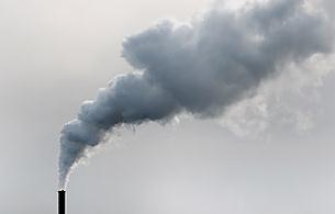
Carbon Tax Best Approach To Curbing Global Warming. I
tend to agree - a straight tax that incentives innovations that reward
lower-carbon=output energy options, like natural gas (and renewables),
while phasing out dirtier fuels. Carbon credits are too easily rigged, a
never-ending shell game that can be endlessly manipulated. I'm no
policy-wonk, but a simplified tax code sounds pretty good to me, and we
should be able to find a way to put a price on carbon dioxide, methane
and other greenhouse gases, like we do for all pollutants. Then step
back and let the markets work. Here's an excerpt of a story at
kentucky.com: "J
ust
when record heat and punishing storms are shriveling climate-change
denial like ears of corn in a Dust Bowl-style drought, along comes news
of a United Nations fiasco that was supposed to reduce heat-trapping
emissions but has instead put more of them into the air — while putting
huge profits into the pockets of those who gamed the system. The New
York Times reports that 19 companies, mostly in India and China, made
tens of millions of dollars by producing more of a heat-trapping gas
that's a byproduct of manufacturing air-conditioning coolants than they
normally would have produced. By destroying the waste gas, they
collected credits worth millions of dollars and tradeable on a global
market. Possible buyers include European power plants trying to meet
greenhouse-gas standards or companies voluntarily offsetting their
carbon footprints."
Read more here: http://www.kentucky.com/2012/08/10/2293288/carbon-tax-best-approach-to-curbing.html#storylink=cpy
The Coming Oil Boom. Great for the word's economies;
tar sands, drilling in the (rapidly thawing) Arctic, and new
technologies like hydro-fracking are releasing vast amounts of new oil
and natural gas. The implications for the atmosphere and accelerated
warming are troubling.
The New York Times reports; here's an excerpt: "...
Thanks
in part to technologies like horizontal drilling and hydraulic
fracking, we are entering a new age of abundant oil. As the energy
expert Leonardo Maugeri contends in a recent report
published by the Belfer Center at the John F. Kennedy School of
Government at Harvard, “contrary to what most people believe, oil supply
capacity is growing worldwide at such an unprecedented level that it
might outpace consumption.” Mr. Maugeri, a research fellow at the Belfer
Center and a former oil industry executive, bases that assertion on a
field-by-field analysis of most of the major oil exploration and
development projects in the world. He concludes that “by 2020, the
world’s oil production capacity could be more than 110 million barrels
per day, an increase of almost 20 percent.” Four countries will lead
the coming oil boom: Iraq, the United States, Canada and Brazil."
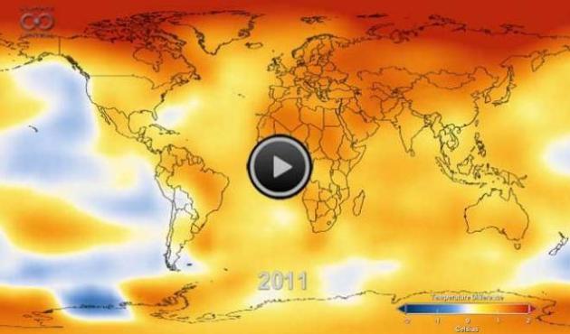
Watch 131 Years Of Global Warming In 26 Seconds. Details, and a compelling video, from
Huffington Post: "
While
temperatures have been blistering this summer, this video takes the
longer historical view. It comes to us from our friends at NASA and is
an amazing 26-second animation depicting how temperatures around the
globe have warmed since 1880. That year is what scientists call the
beginning of the “modern record.” You’ll note an acceleration of those
temperatures in the late 1970s as greenhouse gas emissions from energy
production increased worldwide and clean air laws reduced emissions of
pollutants that had a cooling effect on the climate, and thus were
masking some of the global warming signal. The data comes from NASA's
Goddard Institute for Space Studies in New York, which monitors global
surface temperatures. As NASA notes,
“in this animation, reds indicate temperatures higher than the average
during a baseline period of 1951-1980, while blues indicate lower
temperatures than the baseline average.”
The 5 Most Dangerous Climate Change Myths. Here's an excerpt from
Huffington Post: "...
The
good news is that we may finally be ready to move from debating
climate change to actually doing something meaningful about it. The bad
news? We've lost many years in which progress should have been made to a
corporate-funded disinformation campaign. Time is running out. Our
actions in the next few years will decide whether we can head off
climate change's worst effects -- and that makes it critical not to buy
into these five dangerous myths:
Myth #1: It's all China's fault.
Reality: America must do far more to cut emissions for both moral and practical reasons. Some
U.S. politicians have long used China's growing emissions as an excuse
for inaction. But China has dramatically ramped up solar power use and
still lags far behind the U.S. in per-capita emissions. On a
historical, cumulative basis, we are the world's single largest emitter."
On Floods, China Blames Climate Change. Here's an excerpt from
Forbes.com: “...
Although
the rain is still more frequent in the south than in the north, there
is a tendency that rainstorms sweeping northern provinces are as strong
as those in the south,” Wu Zhenghua, a researcher of the Beijing
Meteorological Bureau and member of Beijing Disaster Relief
Association, said at a news conference on coping with urban flood
disasters held by the China Association for Science and Technology.
Recent record rainfall hit 126.4 millimeters in one hour in Beijing,
while it was not very different from the 115 mm record in Hong Kong, 107
mm in Wuhan, Central China’s Hubei province, and 185 mm in Jinan, East
China’s Shandong province, Wu said."
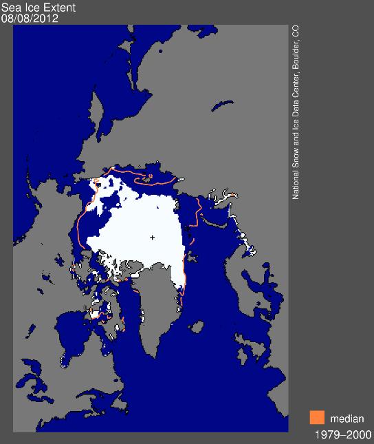
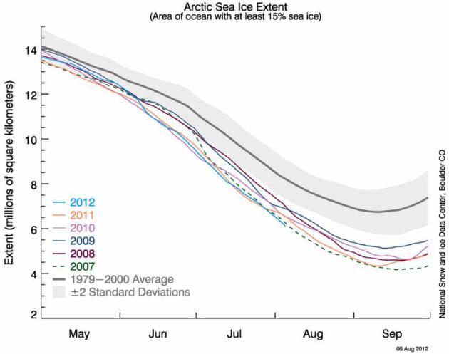
Sea Ice Extent. I took one look at this graphic and
my jaw dropped. We are on target for the lowest summer Arctic ice levels
in recorded history. More details on Sea Ice Extent from the
National Snow And Ice Data Center: "
These
images, derived from passive microwave satellite data, depict the most
recent daily sea ice conditions. Extent images show the total area of
ocean covered with at least 15 percent ice. Concentration images show
varying degrees of ice coverage, from 15 to 100 percent. Monthly images
are more indicative of trends than daily images."
On Track For A Record Sea Ice Minimum. An explanation from NSIDC:
"These
satellite-derived images depict current sea ice conditions and trends.
Long-term changes in Arctic sea ice are an index of climate change.
Southern Hemisphere sea ice images are also available. For more
information about current conditions and their significance, see Arctic Sea Ice News and Analysis."
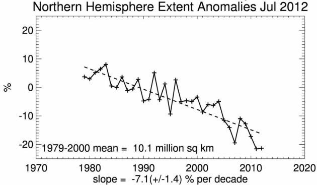
Arctic Sea Ice Extent. We're on track for a new record ice minimum within 30 days. Ice loss may surpass 2007, the previous record.
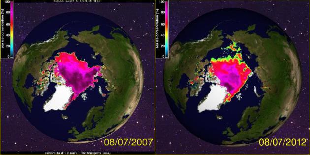
Comparisons With The Previous Record Arctic Ice Minimum.
Comparing early August, 2007 (upper left) with the current state of the
Arctic (upper right), the similarities are striking. Map courtesy of
The Cryosphere Today.
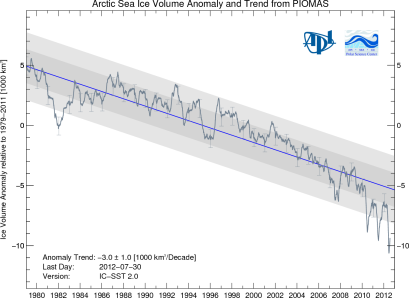
Arctic Sea Ice Volume. Volumetric trends in the Arctic are even more troubling, literally off the scale. Graph: PIOMAS.
To Confront Climate Change, U.S. Agriculture Seeks Hardier Breeds That Can Survive Long Droughts.
Universities and private ventures are already working on new strains of
corn, wheat and beans that can better withstand extended dry spells
(and sudden floods). The financial upside for the firms that figure this
out will be astronomical. Here's a timely story from AP and
The Washington Post: "
Cattle
are being bred with genes from their African cousins who are
accustomed to hot weather. New corn varieties are emerging with larger
roots for gathering water in a drought. Someday, the plants may even be
able to “resurrect” themselves after a long dry spell, recovering
quickly when rain returns. Across American agriculture, farmers and crop
scientists have concluded that it’s too late to fight climate change.
They need to adapt to it with a new generation of hardier animals and
plants specially engineered to survive, and even thrive, in intense
heat, with little rain."
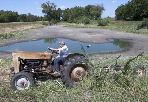
Photo credit above: Nati Harnik, AP. "
Jerry Johnson of
Ashland uses his antique 57 Ford tractor to mow vegetation around his
drying pond in Ashland, Neb., Thursday, Aug. 9, 2012, which he hopes
will keep the critters away."
How To Parse Climate Change And Extreme Weather. Here's an excerpt of a John Broder Op-Ed on connecting the dots in
The New York Times: "
James
E. Hansen, the irrepressible NASA scientist who was among the first to
sound the alarm about human-caused global warming, has roiled the
scientific community again with a new scientific paper
explicitly linking high concentrations of carbon dioxide and other
heat-trapping gases to recent severe heat waves and drought. My
colleague Justin Gillis has a detailed article
in Tuesday’s Times on the study and the initial reaction to it. In the
paper, published in the prestigious Proceedings of the National
Academy of Sciences, Dr. Hansen and two co-authors say that human
activities – chiefly the burning of fossil fuels – have “loaded the
dice,” making extreme weather events more frequent. They go further and
say that the drought in the United States and the deadly heat wave in
Russia, among other recent weather extremes, were direct consequences of
this phenomenon."
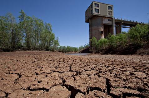
Photo credit above:
Robert W. Hart for The Texas Tribune. "A pump house at Lake J.B. Thomas in west-central Texas sat high and dry last year."
Six Tips For Newly Climate-Concerned Americans. Some good advice from Mike Sandler at The Huffington Post; here's an excerpt: "...
Direct
experience with heat waves and drought may be moving some Cautious and
Disengaged people into the Concerned category. These individuals may
benefit from a few tips for dealing with their new worries about
climate change:
- Build Community -- it helps. If your
existing community watches Fox News, or listens to Rush Limbaugh, then
your new concern about climate change will cause some cognitive
dissonance. That's OK, you'll be facing cognitive dissonance quite a
bit at first, like every time you switch on a light or drive your car.
Joining a community that recognizes the paradoxes that climate change
brings to modern Americans can help during those first troubling weeks,
months, and years.
- Listen to upbeat messages. Upbeat,
positive messages about humanity, or about our ability to change, adapt,
survive, and help each other through tough times can be helpful in
countering anxiety after reading several depressing articles about the
coming climate-pocalypse. A good example is a lyric from Bob Marley's
"Three Little Birds": "Every little thing, gonna be alright."
Climate Change Adaptations: How To Prepare For Global Warming.
Underground cities and floating farms? Hey, who knows - we're all going
to have to think outside the (warming) box to come up with viable
solutions, to grow global economies while mitigating the worst symptoms
of a warmer world. Here's an excerpt from an intriguing story at Huffington Post: " Wild
geoengineering schemes may aim to reverse global warming by reflecting
sunlight into space or storing excess carbon dioxide, but they won't
spare humanity from living through climate change in the next several
decades. That means humans must adapt to life in a world where droughts
hit harder, floodwaters rise higher and entire island nations may sink
beneath the waves. 'Some adaptation ideas resemble science fiction made
real — growing crops inside city buildings, floating villages and
genetically engineered crops. Other solutions, such as floating
agriculture and traditional species cross-breeding, draw upon the long
history of human adaptation rather than futuristic technologies.
Waterworld homes: When the waters rise, tomorrow's buildings may rise with them as floating structures. Koen Olthuis, head of Waterstudio.NL,
has begun working on projects ranging from floating apartments in the
Netherlands to a floating mosque in the United Arab Emirates."


Nice site! I am loving it!! Will come back again ??taking you feeds also, Thanks.
ReplyDeleteHooded sweatshirts