78 F. average high for August 31.
85 F. high on August 31, 2011.
Today: most comfortable day; dew points near 50.
.02" rain predicted for Monday morning (NAM model).
Labor Day: most uncomfortable day as dew points rise into the mid-60s with a high near 90.
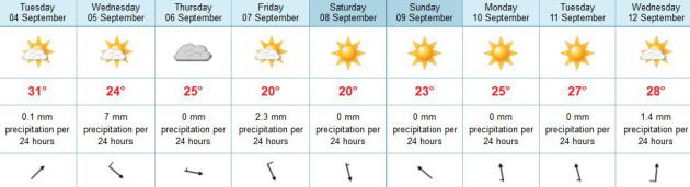
Warm Bias Into Tuesday, Then September-like. The ECMWF keeps highs in the mid 80s to near 90 from Sunday into Tuesday, but by next weekend highs may be stuck in the 60s...even some 50s up north? From shorts to sweatshirts in 3 days.
Labor Day Details. Dew points slowly rise over the weekend, the best chance of a (brief/fleeting) shower or T-shower Sunday morning. Highs on Labor Day may rise into the upper 80s, possibly hitting 90 in the metro for the 29th time this year.
$2 billion in damage from Hurricane Isaac? Details from Bloomberg Businessweek below.
"...The fact is, many people lack the resources to escape. Having no money, no mode of transportation and no friends or family in safe places means no choice but to weather the storm." - from an NBC News story on why some people won't (or can't) evacuate to a safe spot before a hurricane.
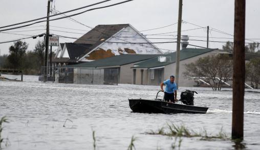
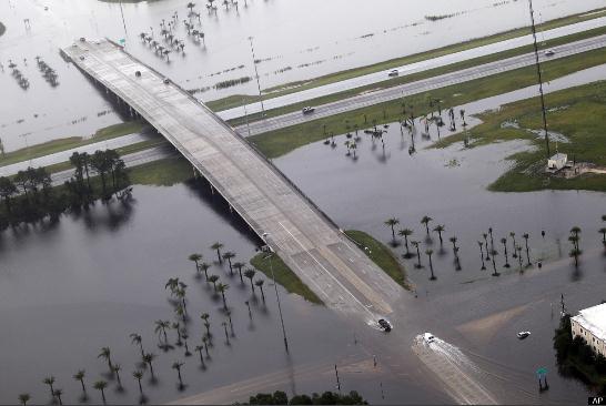
Photo credit above: "A man makes his way down a flooded street in a boat in the aftermath of Isaac Friday, Aug. 31, 2012, in Ironton, La. Isaac is now a tropical depression, with the center on track to cross Arkansas on Friday and southern Missouri on Friday night, spreading rain through the regions." (AP Photo/John Bazemore)
Hurricane Isaac May Cost Insurers $2 Billion; AIR Says. Details from Bloomberg Businessweek; here's an excerpt: "Isaac, the storm drenching Arkansas after making landfall in Louisiana as a hurricane, may cost insurers as much as $2 billion in the U.S., risk-modeling firm AIR Worldwide said. The industry’s claims costs, including wind and storm-surge damage to residential, commercial and industrial onshore properties, will be at least $700 million, the Boston-based firm said today in an e-mailed statement. The estimates are a fraction of the $41.1 billion cost for Hurricane Katrina, the 2005 storm that struck Louisiana and caused flooding in New Orleans. Hurricane Irene, which lashed the U.S. East Coast last year, cost $4.3 billion."
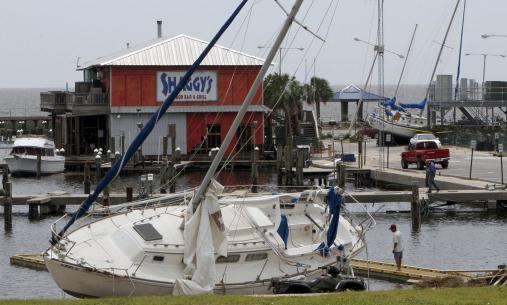
Photo credit above: "Two sailboats, the Sweet Dreams, foreground and the Caribe, were swept from their docks by Hurricane Isaac to the parking lot in front and beside Shaggy's at Pass Christian, Mississipi, on Friday, August 31, 2012." (Tim Isbell/Biloxi Sun Herald/MCT)
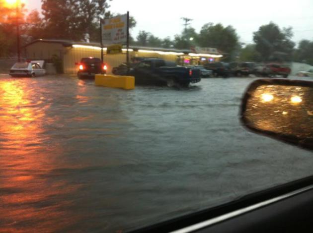
Flooding Spreads North. Jalen Brown captured this photo of severe flooding at Pine Bluffs, Arkansas Friday. Pic via Twitter.


Isaac Rainfall Totals. NOAA data shows over 20" for metro New Orleans. Vero Beach, Florida picked up 16.6" over 4 days.
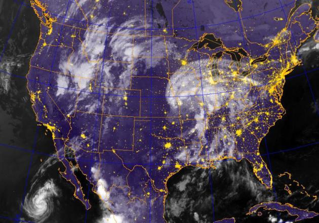
Tropical Swirl. Yes, those high clouds spreading into southeastern Minnesota are the forerunners of "Isaac", which has lost all tropical characteristics. Rain may spread as far north as Iowa and southern Wisconsin, the best chance of flooding from Missouri into central Illinois. IR satellite image: Naval Research Lab.
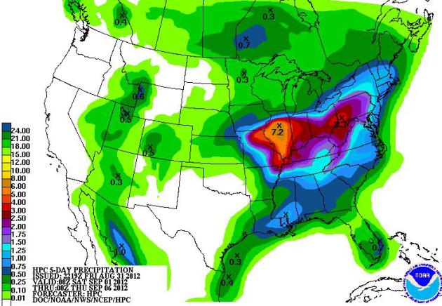
Drought-Denting Rains. NOAA HPC shows some 7"+ rains for Illinois, as much as 3" as far east as Pittsburgh, all from the soggy remnants of Isaac.
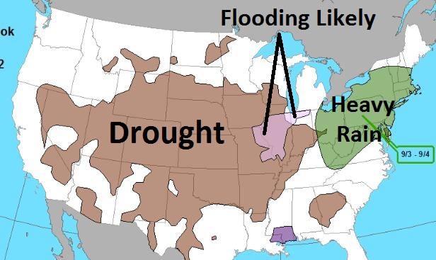
Flood Potential. NOAA has outlined the greatest potential for flash flooding from St. Louis to Peoria, Champaign/Urbana, Chicago and South Bend, Indiana.
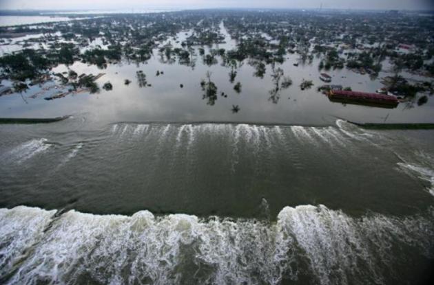
Photo credit above: Vincent Laforet, Pool, File - Associated Press). "In this Aug. 30, 2005 photo, floodwaters from Hurricane Katrina pour through a levee along Innter Harbor Navigational Canal near downtown New Orleans, LA, a day after Katrina passed through the city."
Storm Psychology: Why Do Some People Stay Behind? Great question, and NBC News does a good job providing credible reasons why many people can't (or won't) evacuate to higher ground in advance of a hurricane. Here's an excerpt: "It’s the question so many of us have while watching news coverage of a hurricane or tropical storm like Isaac: Who are these people who don’t leave home even as an angry storm is advancing – and what are they thinking?! The short answer: For some, the up-and-leaving idea isn’t as easy as it sounds to those of us watching from a safe and dry distance. Actually, a 2009 article published in the journal Psychological Science sought to examine the reasons some people won’t evacuate, despite the urging or even mandates of city and state officials, by asking a group who would know: Hurricane Katrina survivors who weathered the storm at home."
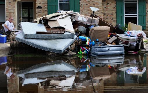
Photo credit above: "Tony Miranda takes a break from clearing out his home after it was flooded by Hurricane Isaac in LaPlace, La., Friday Aug. 31, 2012." (AP Photo/The Advocate. Arthur D. Lauck)

Where: 331 Club in NE Minneapolis, Saturday at 9 pm.
Who:
Band members:
Dan Warner - Lead Vocals and guitar
Walt Kruhoeffer - Lead guitar and Slide guitar
Brian Rubin - Drums
Evan Clark - Bass and Keyboards
Style of music: Blues / rock. With a little bit of funk and southern rock mixed in.
Name of the Album: "Chipper" (Our debut 6 song EP)
Sites: www.thelostwheels.com - Main Site facebook.com/thelostwheels - Facebook @thelostwheels - Twitter

Fantastic Friday. Is this the best
time of the year in Minnesota? A loaded question, and highly
subjective. But the combination of bright sun, low humidity and a fresh
breeze made it awfully tough to concentrate. Highs ranged from 83 at
Redwood Falls and Alexandria to 84 St. Cloud, 86 Twin Cities and 89 at
Eau Claire.
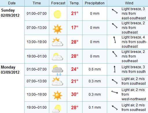
Paul's Conservation Minnesota Outlook for the Twin Cities and all of Minnesota
TODAY: Sunny & pleasant. Dew point: 51. Winds: SE 10-15. High: 85
SATURDAY NIGHT: Partly cloudy and mild. Low: 66.
SUNDAY: Partly sunny, warmer and more humid. Dew point: 60. Winds: S 10. High: 88
SUNDAY NIGHT: Clouds increase, chance of a shower or T-shower. Low: 68
LABOR DAY: Passing T-shower, then partial clearing, still very warm. Dew point: 66. Winds: W 5-15. High: 89
TUESDAY: Hazy sun, still sticky. Dew point: 63. Low: 64. High: 86
WEDNESDAY: Showers likely, then breezy, cooler. Low: 65. High: 78
THURSDAY: Feels like September! Less humid with plenty of sun. Low: 58. High: 72
FRIDAY: Comfortable sun, light winds. Low: 55. High: 74

Fantasy Weather Picks
Feeling good about your fantasy football team?
This is the year. Victory is mine!
My oldest son, lead guitarist for "The Lost Wheels", is a football fanatic. "How can I possibly know how well Andrian Peterson's knee will hold up after Game 4?" Walt asked. I shrugged. Welcome to my world. Some things are not only unpredictable, but unknowable.
Climate Stories....
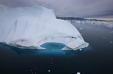
 Is Geoengineering The Answer To Climate Change? Tinkering with the atmosphere - what can possibly go wrong? Here's an excerpt of an interesting article at Smithsonian Magazine: "Climate change used to be thought of as a long-term worry; now, there’s good reason to believe we’re already encountering its effects.
As the problem grows more urgent, some say we ought to take a radical
approach: Instead of struggling in vain to limit greenhouse gas
emissions, we should try to engineer systemsto
directly stop the warming of the planet. This approach is known as
geoengineering, and it might be the most controversial area in climate
science. The term encompasses a wide variety of techniques. One company
tried to fertilize the ocean with iron, to encourage the growth of algae to absorb excess carbon dioxide. Other scientists have suggested spraying clouds with seawater
to increase their whiteness—and thus reflectivity—reducing warming by
bouncing light back out to space. The U.S. government has even
considered gigantic, sun-blocking mirrors in outer space as a last-ditch option if climate change hits a tipping point."
Is Geoengineering The Answer To Climate Change? Tinkering with the atmosphere - what can possibly go wrong? Here's an excerpt of an interesting article at Smithsonian Magazine: "Climate change used to be thought of as a long-term worry; now, there’s good reason to believe we’re already encountering its effects.
As the problem grows more urgent, some say we ought to take a radical
approach: Instead of struggling in vain to limit greenhouse gas
emissions, we should try to engineer systemsto
directly stop the warming of the planet. This approach is known as
geoengineering, and it might be the most controversial area in climate
science. The term encompasses a wide variety of techniques. One company
tried to fertilize the ocean with iron, to encourage the growth of algae to absorb excess carbon dioxide. Other scientists have suggested spraying clouds with seawater
to increase their whiteness—and thus reflectivity—reducing warming by
bouncing light back out to space. The U.S. government has even
considered gigantic, sun-blocking mirrors in outer space as a last-ditch option if climate change hits a tipping point."
Photo credit above: "Geoengineering could replicate the cooling effects of a massive volcanic eruption as a tool to reduce climate change." Photo via Wikimedia Commons
 GOP Platform Highlights The Party's Abrupt Shift On Energy, Climate. Here's an excerpt from The Washington Post: "Over
the past four years, the Republican Party has undergone a fairly
dramatic shift in its approach to energy and environmental issues.
Global warming has disappeared entirely from the party’s list of
concerns. Clean energy has become an afterthought. Fossil fuels loom
larger than ever. And one way to see this shift clearly is to compare
the party’s 2008 and 2012 platforms. It may seem difficult to believe
now, but back in 2008, the Republican Party’s platform (pdf) had a long and detailed section on “Addressing Climate Change Responsibly.” Here’s how it opened:
GOP Platform Highlights The Party's Abrupt Shift On Energy, Climate. Here's an excerpt from The Washington Post: "Over
the past four years, the Republican Party has undergone a fairly
dramatic shift in its approach to energy and environmental issues.
Global warming has disappeared entirely from the party’s list of
concerns. Clean energy has become an afterthought. Fossil fuels loom
larger than ever. And one way to see this shift clearly is to compare
the party’s 2008 and 2012 platforms. It may seem difficult to believe
now, but back in 2008, the Republican Party’s platform (pdf) had a long and detailed section on “Addressing Climate Change Responsibly.” Here’s how it opened:
My oldest son, lead guitarist for "The Lost Wheels", is a football fanatic. "How can I possibly know how well Andrian Peterson's knee will hold up after Game 4?" Walt asked. I shrugged. Welcome to my world. Some things are not only unpredictable, but unknowable.
Every day I check the current maps and future
models, choosing the one I think may do the best job, under these
circumstances. But like an unexpected football injury - not every
conceivable factor can be stuffed into a weather model. There was no way
to forecast, in advance, that "training thunderstorms" would spark a 1
in 500 year flood at Duluth in June. No way to know, days in advance,
that Hurricane Isaac would stall, and do a big loop off the coast of
Louisiana, proloning the storm surge and extreme rains, causing a
Category 1 storm to produce Category 3 damage.
Predicting the future is hard work; there's so much we can never know. A good metaphor for life, come to think of it.
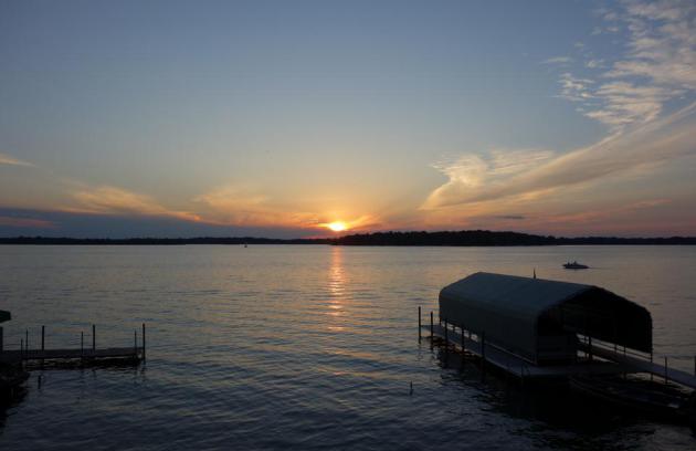
No extreme heat or beach-ball size hail? It's a
miracle, lake-friendly skies on a holiday! Comfortable 80s today, near
90 tomorrow as dew points rise into the sticky 60s. The best chance of a
shower or T-storm: Monday morning/midday, but skies may clear during
the afternoon. Not bad for the last holiday of summer '12.
It could be worse. So much worse. On August 30,
1949 Minnesota's earliest snow flurries on record were spotted at
Duluth's new airport, up on the bluffs.
Cue the groans!
Photo credit above: "Geoengineering could replicate the cooling effects of a massive volcanic eruption as a tool to reduce climate change." Photo via Wikimedia Commons
"The same human economic activity that has brought freedom and opportunity to billions has also increased the amount of carbon in the atmosphere. While the scope and longterm consequences of this are the subject of ongoing scientific research, common sense dictates that the United States should take measured and reasonable steps today to reduce any impact on the environment. Those steps, if consistent with our global competitiveness will also be good for our national security, our energy independence, and our economy."Photo credit above: "No longer a Republican concern." (JOHN MCCONNICO / AP)
No comments:
Post a Comment