78 F. average high for August 30.
71 F. high on August 30, 2011.
1.38" rain so far in August; 2.8" less than average, to date.
+.2 F. After a cool couple of weeks, recent warmth has pulled the average MSP temperature for August to two/tenths of a degree F. above average.
Summer Data Bank:

3rd hottest summer since 1891. Only 1988 and 1934 were a fraction of 1 F. warmer.
44% Based on NWS cooling degree data we used 44% more electricity to cool our homes and offices this summer.



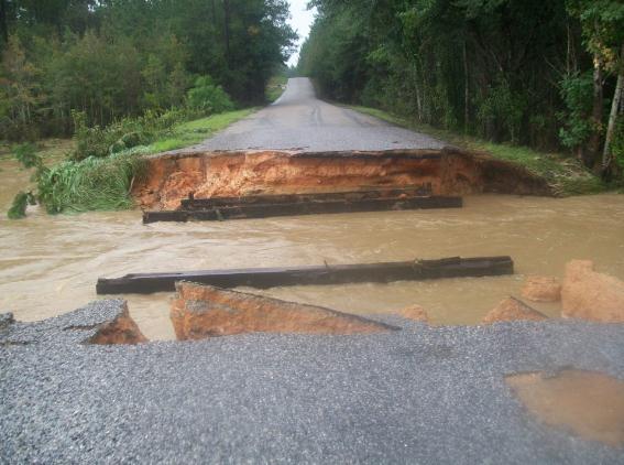
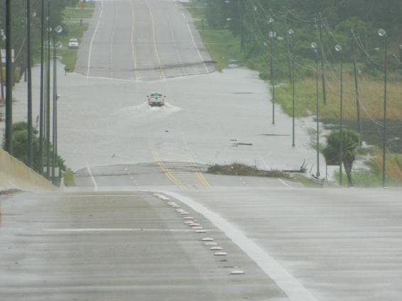
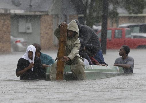
Isaac Headlines:
* Flooding areas north and south of New Orleans, and officials had
to scramble to evacuate and rescue people as waters quickly rose.
* Along the shores of Lake Pontchartrain near New Orleans, officials sent scores of buses and dozens of high-water vehicles to help evacuate about 3,000 people as rising waters lapped against houses and left cars stranded
* Floodwaters rose waist-high in some neighborhoods, and the Louisiana National Guard was working with sheriff’s deputies to rescue people stranded in their homes.
 Severe Flooding. Details: "A submerged cow is
stranded amid debris in floodwaters after Isaac passed through the
region, in Plaquemines Parish, La., Thursday, Aug. 30, 2012. Isac
staggered toward central Louisiana early Thursday, its weakening winds
still potent enough to drive storm surge into portions of the coast and
the River Parishes between New Orleans and Baton Rouge." (AP Photo/Gerald Herbert)
* The LouisianaNational Guard ceased rescue operations in Plaquemines Parish, saying it felt confident it had gotten everyone out. There were no serious injuries. National Guard spokesman Capt. Lance Cagnolatti said guardsmen would stay in the area over the coming days to help.
* To the east, evacuations were ordered in a sparsely-populated area as a lake dam threatened to break near the Mississippi-Louisianaborder. Officials in Tangipahoa Parish, La., feared the water it would pour into the already swollen river would flood low-lying areas downstream. Louisiana Gov. Bobby Jindal said officials there would release water at the dam.
* The hardest-hit area was Plaquemines Parish, southeast of New Orleans, where floodwaters overtopped at least one levee on Wednesday and left many homes under about 12 feet of water.
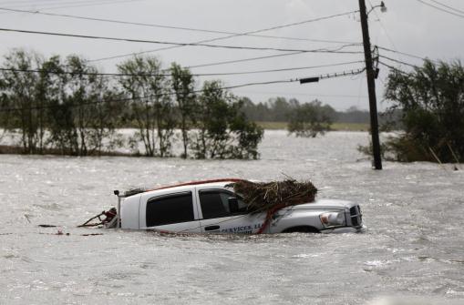 Entire Louisiana Parishes Submerged. Details: "A
car sits submerged after Isaac passed through the region, in
Plaquemines Parish, La., Thursday, Aug. 30, 2012. Isaac staggered
toward central Louisiana early Thursday, its weakening winds still
potent enough to drive storm surge into portions of the coast and the
River Parishes between New Orleans and Baton Rouge." (AP Photo/Gerald Herbert)
* Parish President Billy Nungesser said U.S. Army National Guard troops and local sheriff’s office officials were going house to house through the area on Thursday to ensure that there were no deaths or injuries.
* Clearing weather permitted the use of military helicopters, mostly UH-60 Blackhawks, to aid in the operation.
* In St. John the Baptist Parish, northwest of the city, about 3,000 people were forced to evacuate their homes before dawn on Thursday due to storm surges from Lake Pontchartrain and Lake Maurepas, authorities said.
* In Slidell, a town of about 27,000 people northeast of New Orleans, storm surge from Lake Pontchartrain left the Eden Isle community under about a foot of water.
* Emergency services rescued about 350 people from Slidell homes and neighboring communities hit by more severe flooding, local authorities said.
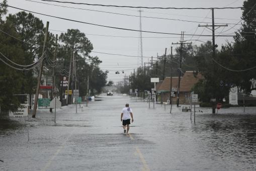 A Lonely Walk. Although downtown New Orleans dodged a
bullet with Isaac, surrounding suburbs (not protected by the new levee)
weren't nearly as lucky. Details: "A man walks through floodwaters
from Tropical Storm Isaac in Jean Lafitte, La., Aug. 30, 2012. The
storm's once fierce winds slowed to 45 miles per hour on Thursday as it
moved out of southern Louisiana and headed north, continuing to bring
heavy rains and flooding." (Michael Appleton/The New York Times)
* Nearly half of Louisianaelectrical customers lost power and another 150,000 were out in neighboring Mississippi. Louisiana’s Public Service Commission said 901,000 homes and businesses around the state — about 47 percent of all customers — were without power Thursday. Utility company Entergy said that included about 157,000 in New Orleans.
* New Orleans’ biggest problems seemed to be downed power lines, scattered tree limbs and minor flooding. One person was reported killed, compared with 1,800 deaths from Katrina in Louisiana and Mississippi.
* Multibillion-dollar defenses built to protect New Orleans itself, after it was ravaged by Katrina almost exactly seven years ago, passed their first major test, according to the U.S. Army Corps of Engineers.
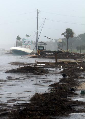 Storm Surge Aftermath. Tides rose 8-12 feet across
coastal Mississippi and Louisiana, and although water levels dropped
slightly today as Isaac's winds diminished, coastal areas remained
engulfed in water. Details: "Debris lines the parking lot of the Pass Christian Harbor on Thursday, August 30, 2012." (Amanda McCoy/Biloxi Sun Herald/MCT)
* A Coast Guard helicopter hoisted a couple and their dogs early Thursday from a home in LaPlace, between the Mississippi Riverand Lake Ponchartrain, The couple was taken to New Orleans and reported in good condition.
* The oil and gas industry in the Gulf of Mexico region has so far reported no major storm-related damage to infrastructure. Energy production was expected to start ramping up again, after nearly grinding to a halt as Isaac closed in on Louisiana on Tuesday.
* President Barack Obama declared federal emergencies in Louisiana and Mississippi late Wednesday, allowing federal aid to be freed up for affected areas.
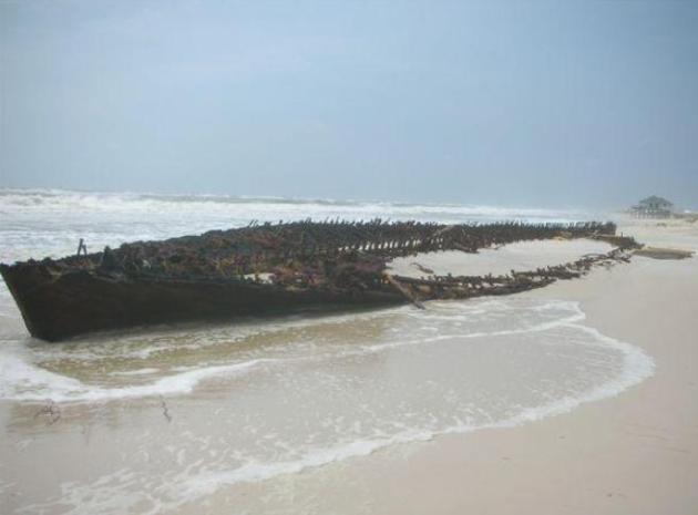 Mystery Ship Near Fort Morgan. Look what washed up
on the beach at Gulf Shores, Mississippi - whipped along by Isaac's
storm surge, wreckage of an old shipwreck. Details from Meyer Vacation
Rentals via Facebook: "Look
what Isaac uncovered! The first recent appearance of this mystery
ship, believed to have been a blockade runner during the Civil War, was
during Hurricane Ivan in 2004. In 2008, Hurricane Ike gave us a bigger
glimpse. And now in 2012, Hurricane Isaac is giving us a nearly full
view. Hmmm . . . 2004, 2008, 2012. All hurricanes with names beginning
with I. All within a couple of weeks on the calendar. While we hope it's
the end of the pattern, we must admit it sure is interesting to see it
appear!"
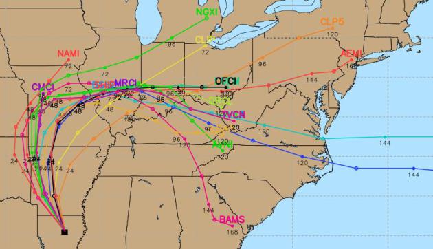
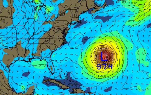 Hurricane Leslie? Still a tropical storm, "Leslie"
is forecast to become a hurricane, and then recurve to the
north/northwest, posing some risk to Bermuda. The map above shows a
strong Category 3 Hurricane Leslie next Friday, September 7. Odds are it
will stay out to sea, but an approaching trough of low pressure may
nudge Leslie farther to the northwest. New England will probably
experience strong swells from this major hurricane; right now the odds
of landfall over the USA are small, less than 1 in 10.
* Along the shores of Lake Pontchartrain near New Orleans, officials sent scores of buses and dozens of high-water vehicles to help evacuate about 3,000 people as rising waters lapped against houses and left cars stranded
* Floodwaters rose waist-high in some neighborhoods, and the Louisiana National Guard was working with sheriff’s deputies to rescue people stranded in their homes.

* The LouisianaNational Guard ceased rescue operations in Plaquemines Parish, saying it felt confident it had gotten everyone out. There were no serious injuries. National Guard spokesman Capt. Lance Cagnolatti said guardsmen would stay in the area over the coming days to help.
* To the east, evacuations were ordered in a sparsely-populated area as a lake dam threatened to break near the Mississippi-Louisianaborder. Officials in Tangipahoa Parish, La., feared the water it would pour into the already swollen river would flood low-lying areas downstream. Louisiana Gov. Bobby Jindal said officials there would release water at the dam.
* The hardest-hit area was Plaquemines Parish, southeast of New Orleans, where floodwaters overtopped at least one levee on Wednesday and left many homes under about 12 feet of water.

* Parish President Billy Nungesser said U.S. Army National Guard troops and local sheriff’s office officials were going house to house through the area on Thursday to ensure that there were no deaths or injuries.
* Clearing weather permitted the use of military helicopters, mostly UH-60 Blackhawks, to aid in the operation.
* In St. John the Baptist Parish, northwest of the city, about 3,000 people were forced to evacuate their homes before dawn on Thursday due to storm surges from Lake Pontchartrain and Lake Maurepas, authorities said.
* In Slidell, a town of about 27,000 people northeast of New Orleans, storm surge from Lake Pontchartrain left the Eden Isle community under about a foot of water.
* Emergency services rescued about 350 people from Slidell homes and neighboring communities hit by more severe flooding, local authorities said.

* Nearly half of Louisianaelectrical customers lost power and another 150,000 were out in neighboring Mississippi. Louisiana’s Public Service Commission said 901,000 homes and businesses around the state — about 47 percent of all customers — were without power Thursday. Utility company Entergy said that included about 157,000 in New Orleans.
* New Orleans’ biggest problems seemed to be downed power lines, scattered tree limbs and minor flooding. One person was reported killed, compared with 1,800 deaths from Katrina in Louisiana and Mississippi.
* Multibillion-dollar defenses built to protect New Orleans itself, after it was ravaged by Katrina almost exactly seven years ago, passed their first major test, according to the U.S. Army Corps of Engineers.

* A Coast Guard helicopter hoisted a couple and their dogs early Thursday from a home in LaPlace, between the Mississippi Riverand Lake Ponchartrain, The couple was taken to New Orleans and reported in good condition.
* The oil and gas industry in the Gulf of Mexico region has so far reported no major storm-related damage to infrastructure. Energy production was expected to start ramping up again, after nearly grinding to a halt as Isaac closed in on Louisiana on Tuesday.
* President Barack Obama declared federal emergencies in Louisiana and Mississippi late Wednesday, allowing federal aid to be freed up for affected areas.


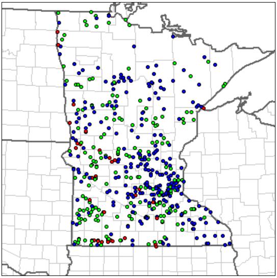
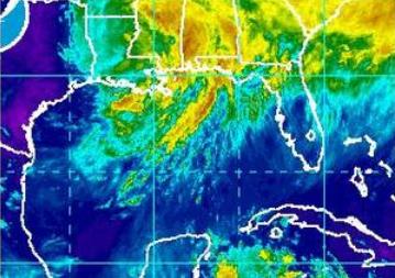


* if you really have your heart set on a monstrous 145" 4K TV, check this out. Only one small problem: there's no 4K content...yet.


Paul's Prediction: An Up and Coming Minnesota Band: "The Lost Wheels". O.K. I'm a little biased here, but I know great music (and lyrics) when I hear it. If you like rock and blues you'll really like these guys. They have a unique sound and an energy that you don't find very often. Here's the deal: they just released their first CD "Chipper" and they're having a CD Release Party & Concert Saturday evening. If you've had your fill of sugar-on-a-stick at the State Fair and looking for something a little different, come by, say hi, and support local Minnesota music in the process. There's a 94% probability you'll have a good time.
Where: 331 Club in NE Minneapolis, Saturday at 9 pm.
Who:
Band members:
Dan Warner - Lead Vocals and guitar
Walt Kruhoeffer - Lead guitar and Slide guitar
Brian Rubin - Drums
Evan Clark - Bass and Keyboards
Style of music: Blues / rock. With a little bit of funk and southern rock mixed in.
Name of the Album: "Chipper" (Our debut 6 song EP)
Sites: www.thelostwheels.com - Main Site facebook.com/thelostwheels - Facebook @thelostwheels - Twitter
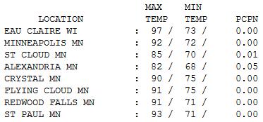
Day 28. Thursday was the 28th day this summer season at or above 90 F. in the Twin Cities. Yes, that's quite enough. I still think we may see 1-3 more before heavy-duty cold fronts start dive-bombing south of the border, but then again a). I kind of like the heat (even without A/C) and b). I'm a naive optimist and I want summer to hang on indefinitely. Under a partly sunny sky highs ranged from 82 at Alexandria to 85 St. Cloud, 92 in the Twin Cities and 97 at Eau Claire.

Paul's Conservation Minnesota Outlook for the Twin Cities and all of Minnesota:
TODAY: Some relief. Sunny, cooler, and less humid. Dew point: 46. Winds: NE 10-15. High: 84
FRIDAY NIGHT: Clear and comfortable. Low: 67
SATURDAY: Partly sunny. The more comfortable day of the weekend. Dew point: 57. Winds: SE 15. High: 86
SUNDAY: Sticky, hotter with hazy sun. Dew point: 65. Winds: South 15+. Low: 66. High: near 90
SUNDAY NIGHT: More clouds, slight chance of a shower or T-shower. Low: 69
LABOR DAY: Isolated early shower, then clearing - less humid. Dew point: 61. High: 86
TUESDAY: Still muggy, late T-storms. Low: 68. High: 83
WEDNESDAY: Stormy start, slow clearing. Low: 62. High: near 80
THURSDAY: Clouds increase, late rain in the day. Low: 58. High: 75

3rd Hottest Summer
You just enjoyed/endured the 3rd hottest summer
on record. Only 1988 and 1933 were a fraction of a degree hotter,
according to Pete Boulay, at the climate office. 28 days of 90+. Average
is 13. Two days of 100+, the most since 1988. Based on NWS cooling
degree data we've used 45 percent more electricity to cool our homes.
Ouch.
July was rough, but records show 177 hours of drippy, 70+ dew points. Average for the summer season is 180 hours.
A stubborn heat-pump high nudged the jet stream
500 miles farther north; severe storms detouring over Canada. No metro
tornadoes in 2012, but Duluth saw the second (weak, EF-0) tornado in
it's history! That, and a 1 in 500 year flood. Very odd.
Yes, it's been hot, and a brewing El Nino may
tip the scales in favor of another milder winter. But snow lovers should
keep the faith. 1988 was a scorcher, but MSP picked up 25 inches of
snow between October and December of that year.
Here's some fun party trivia: the first flurries up north are about 30 days away, on average.
Warm sun prevails into Labor Day; a 1 in 3
chance of a brief Monday shower. Soak up the heat because jacket weather
is brewing for late next week.
Summer's last hurrah?
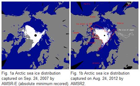
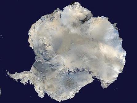
This region is experiencing twice the global average of climate warming. While satellite images reveal thousands of kilometers of milky-cloudy waters along the Arctic coast, suggesting a massive influx of material, the Yedoma has remained understudied largely due to the region’s inaccessibility. By studying the thaw-eroding slopes of a disappearing island, the team found that the tens-of-thousands year old coastal Yedoma carbon is rapidly converted to CO2 and methane, even before being washed into the sea."
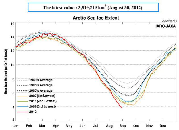
Graph above courtesy of the Arctic Sea-Ice Monitor.



No comments:
Post a Comment