86 F. high on Sunday in the Twin Cities.
79 F. average high for August 26.
87 F. high on August 26, 2011.
90 F. possible tomorrow afternoon; low to mid 90s likely Wednesday into Friday. Slight cooling is likely by Sunday.
Alerts Broadcaster. In light of "Isaac" threatening
the northern Gulf of Mexico, I'm going to post an update that went out
to some of our corporate customers late last night. I want you to have a
better understanding of the risks and lingering uncertainties with
Isaac. Although it's not in the same league as Katrina in 2005, a
Category 2 hurricane is still formidable and dangerous.
Alerts Broadcaster “Isaac” Update
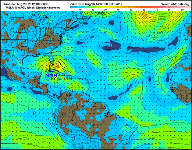
GFS Solution. This
animation is courtesy of Ham Weather, showing "Isaac" pushing into
coastal Louisiana by Tuesday afternoon, possibly as a Category 2
hurricane.
Big Picture Observations on “Isaac”:
1). Arrested Development.
As of 9:30 pm central time Isaac was still a (strong) Tropical Storm.
There was little strengthening today as it tracked over the Florida
Keys. Isaac is passing over warmer water in the Gulf of Mexico with
light winds aloft (little wind “shear”). The storm should become a
hurricane Monday, probably strengthen to Category 2 strength by Tuesday.
2). Landfall.
There is still a fair amount of disagreement among computer
simulations, but Hurricane Isaac is most likely to come ashore over
Louisiana, sometime late Tuesday or Wednesday morning, with sustained
winds of 100-110 mph and a storm surge of 5-8 feet, possibly higher in
some areas. A State of Emergency exists in New Orleans, where memories
of Katrina are still fresh in everyone’s mind. Although this doesn’t
look as intense as Katrina (which was a Category 4 hurricane as it came
ashore east of New Orleans) Isaac may still cause its fair share of
problems along the northern Gulf Coast.
3). Timing.
Today will be the day to accelerate contingency plans and preparations
along the Gulf Coast. Conditions will go (rapidly) downhill Tuesday,
with the most severe winds and storm surge Tuesday afternoon into
Wednesday morning, the worst coastal flooding and beach erosion from New
Orleans east to Gulfport and Mobile, Alabama.
4). Inland Flooding.
Based on the current consensus track of Isaac, inland flash flooding is
most likely from Little Rock and Tulsa to Kansas City, St. Louis, and
Chicago. Details below. Remember, some of the worst impacts from Irene
were found in Vermont, 2 days after landfall and 350 miles inland. The
same thing may happen with Isaac.
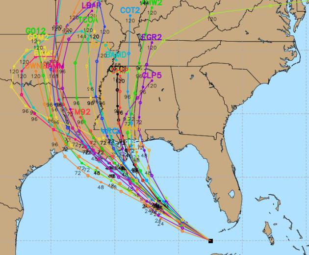
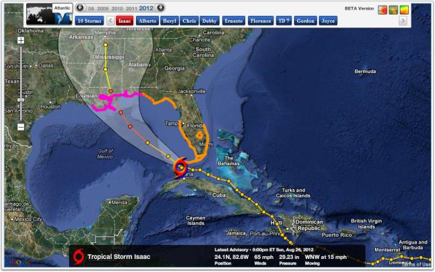
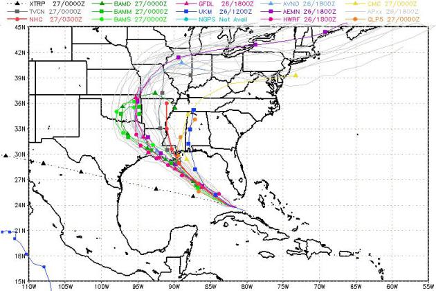
Isaac’s Projected Track. In a perfect world there would be one solid
line extending northwestward from “Isaac”. No such luck. The “fan” of
tracks shows a fair degree of disagreement among the various U.S.
computer simulations. A rough average of these solutions would take
Isaac very close to New Orleans late Tuesday.
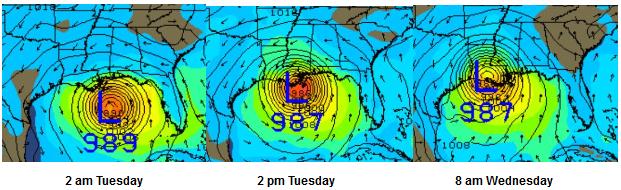
GFS Solution. The U.S. model suite has been fairly
consistent today, taking the core of a (considerably stronger) Hurricane
Isaac into Louisiana by Tuesday PM hours. Forward motion slows down
Tuesday night, prolonging excessive rains (and the storm surge, an
elevated dome of water pushed ashore by the combination of low pressure
and extreme winds). Tides may rise 5-10 feet above average from
Louisiana’s Mississippi River Delta eastward to Gulfport and Mobile.
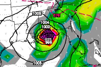
The Source of Considerable Heartburn.
The European ECMWF (above), which often does a better job than the GFS
model, continues to show landfall near Mobile or Pensacola, some 300
miles farther east than the GFS and most U.S. models are suggesting.
This is a big reason why confidence levels are still relatively low. Map
above is valid 1 pm Wednesday.
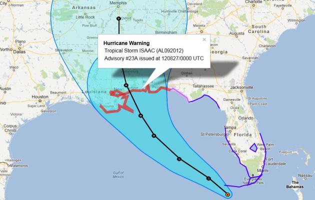
Hurricane Warnings. Mandatory Hurricane Warnings are currently
in effect from near Houma, Louisiana to Fort Walton and Destin, Florida.
Remember, the worst wind/wave damage takes place to the right/east of
the hurricane track. The “storm surge” will push water into Lake
Pontchartrain – officials holding their breath that the new and improved
levee system will, in fact, protect the city. It’s rated to Category 4.
Isaac should hit as a Category 2, possibly a marginal Category 3
hurricane, with sustained winds in the 100-115 range.
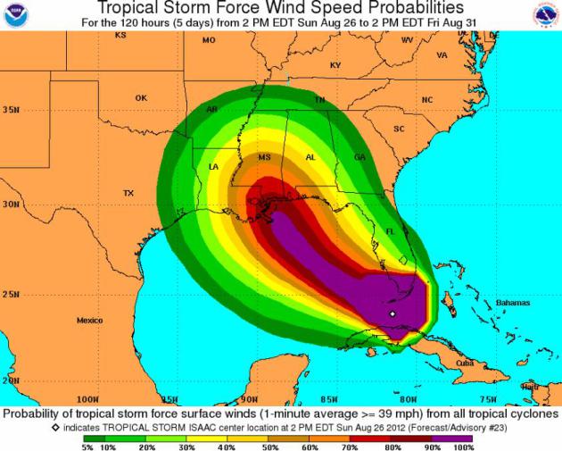
Probability Of Tropical Storm-Force Winds.
Hurricane-force winds may ultimately impact a 100-200 mile wide band as
Isaac comes ashore Tuesday PM hours into Wednesday morning. Map above
from NOAA NHC.
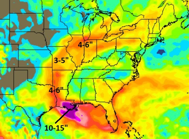
Flash Flood Potential. The GFS model prints out some 10-15” rains
for Lafayette and New Orleans, with an arc of 3-6” rains extending
northward into Shreveport, Little Rock, Kansas City, Peoria and the
Chicago area by Friday. It’s difficult to say where the heaviest rain
bands will set up, but remember than inland flooding can be a
significant factor days after landfall, 200-600 miles inland from where
Isaac makes landfall.
Alerts Broadcaster Model Consensus.
Here is an average of all the (U.S.) computer simulations, bringing the
eye of Isaac close to Gulfport, Mississippi by Tuesday night.
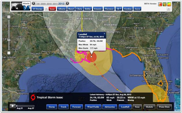
Alerts Broadcaster Landfall Details.
Latest models show sustained winds of 94 mph, with gusts to 117 along
the coast of Louisiana at 11:55 pm on Tuesday. That would make “Isaac” a
Category 2 storm. There is at least a 1 in 3 chance that Isaac may
strengthen to Category 3 strength. Why?
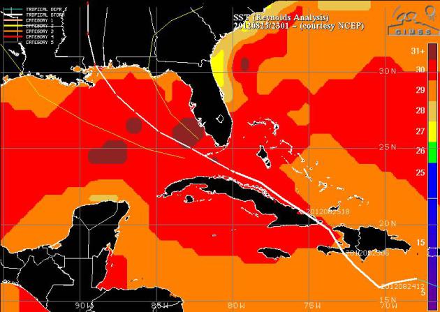
Elevated Sea Surface Temperatures.
Isaac is passing over warm water, the “Loop Current” in the Gulf of
Mexico. The warmer the ocean water, the greater the potential for
hurricane intensification. One wildcard: wind shear. Winds aloft appear
to be light, favorable for strengthening today. We will know within
12-24 hours whether Isaac will hit the Gulf Coast as a minor hurricane,
or a major (Category 3+) storm. Map: University of Wisconsin CIMSS.
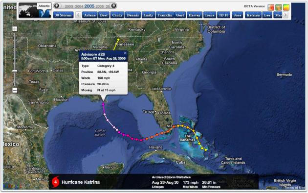
Perspective. Thanks to Alerts Broadcaster’s sister
company, Ham Weather, I can call up the track of Hurricane Katrina,
which struck on August 23-24, 2005. At one point before landfall Katrina
was a rare Category 5 hurricane; it weakened slightly before coming
ashore, but the flooding and misery, especially in New Orleans, will
never be forgotten. You can understand why a State of Emergency is in
effect for New Orleans and coastal parishes of Louisiana. Although Isaac
won’t be nearly as fierce as Katrina was 7 years ago, all hurricanes
should be treated with a high degree of respect and humility. Isaac is
no exception.

Summary. Just once I
wish the forecast was cut and dry, black and white. It’s not. There’s a
70-75% probability that Isaac will come ashore as a Category 2 hurricane
late Tuesday, probably over the coast of Louisiana or Mississippi. A
4-8 foot storm surge is expected, higher in some areas, with 10-15”
rains for coastal communities and severe flash flooding. In addition
scattered tornadoes are likely within 200 miles of landfall as a rapidly
spinning Isaac interacts with ground features and friction to spin up
mostly small, brief twisters. This is a dangerous situation, especially
within 2-3 miles of the Gulf of Mexico. Many barrier islands and coastal
highways will be cut off by midday Tuesday. Today is the day to
evacuate barrier islands in the Hurricane Warning and drive at least
25-50 miles inland. Facility hurricane contingency plans should be in
effect extreme eastern Texas across Louisiana into coastal Mississippi
and Alabama. There is still a 25-30% risk that Isaac will turn north
faster, in which case landfall would be closer to Mobile or Pensacola.
Paul Douglas
Senior Meteorologist
Alerts Broadcaster
A Meteorological All-Nighter. Thanks to CBS Miami for sharing the photo, which, come to think of it, looks like a bad Red Bull commercial.
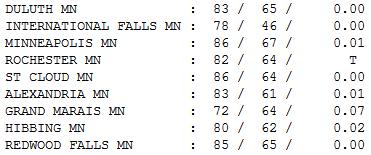
Summer At Its Best. Morning fog and stratus burned
off, revealing a stunning Sunday afternoon, high temperatures 5-10
degrees warmer than average, a trend that will continue into next
weekend. Highs ranged from 72 at Grand Marais to 86 at St. Cloud and the
Twin Cities.
Paul's Conservation Minnesota Outlook for the Twin Cities and all of Minnesota:
MONDAY: Another perfect Monday. Sunny with low humidity. Dew point: 50. Winds: NW 8. High: 85
MONDAY NIGHT: Clear and pleasant. Low: 63
TUESDAY: Warm sun, beautiful. Dew point: 54. High: 89
WEDNESDAY: Hot sun, tolerable humidity. Dew point: 55. Low: 68. High: 93
THURSDAY: Dog Days of August. Dew point: 59. Low: 69. High: 94
FRIDAY: Lot's of sun, still steamy. Dew point: 61. Low: 68. High: near 90
SATURDAY: Get to the lake (or fair). Hot sun. Dew point: 63. Low: 67. High: 88
SUNDAY: Some sun, less humid PM. Dew point: 53. Low: 64. High: 83
Hurricane of Confusion
Unlike tornadoes, which both terrify and
fascinate, hurricanes may serve a purpose in nature. They are giant
atmospheric pressure-relief valves, transporting excess heat and
moisture away from the tropics. They often relieve droughts, sometimes
in a meteorological blink of an eye. Cue Isaac. Farms from Texas to
Missouri may go from drought to flood, overnight.
So where is Isaac headed? Away from Florida.
Good news for the RNC and The Tampa Chamber of Commerce. But this
Texas-size storm is proving harder than most to predict. The latest
computers show a midweek landfall on the Louisiana coast; Isaac pushing a
4-8 feet dome of water ahead of the eye.
Forecasting a hurricane's track is somewhat
easier than intensity. Warm, 82 F water may cause Isaac to strengthen
into a 100-115 mph "Category 2-3"; not as strong as Katrina in 2005, but
formidable nonetheless. Latest details on the blog.
Welcome to the Dog Days of August: 80s all week;
a few models hinting at 90+ in 2-3 days, maybe some mid-90s by mid
week. No significant rain in sight the next 7-10 days.
A few models are hinting at torrential rains
from Isaac as close as Chicago. About once a decade WE see the soggy
dregs of a hurricane. Not this time.


No comments:
Post a Comment