87 F. high Monday in the Twin Cities.
79 F. average high for August 27.
79 F. high on August 27, 2011.
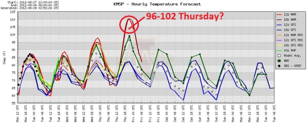
100 F. high possible Thursday in the Twin Cities.
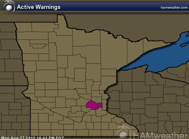
Excessive Heat Watch posted for Thursday in Hennepin and Ramsey counties.
9.87" rain since June 1.
12.11" average rainfall since June 1. We're running a
2.24" rainfall deficit in the Twin Cities since the start of
meteorological summer.
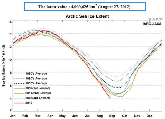
Arctic Sea Ice Reaches Record Minimum. The chart above is
here, courtesy of The Arctic Sea-Ice Monitor. Details from Christian Science Monitor and The New York Times below.
"What we know is that since 1995 no hurricane making landfall
from Louisiana to the Florida panhandle produced fewer than 11
tornadoes in its life, including post-landfall while the system
remained an identifiable and separate mid-level entity." - from a post at ustornadoes.com, details below.
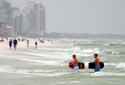
Photo credit above: "
Tourists wade out of the rough water
caused by Tropical Storm Isaac in Destin, Fla., Monday, Aug. 27, 2012.
Isaac, which may strengthen to a hurricane, could pack a watery double
punch for the Gulf Coast. If it hits during high tide, Isaac could push
floodwaters as deep as 12 feet onto shore in Louisiana, Mississippi
and Alabama and up to 6 feet in the Florida Panhandle, while dumping up
to 18 inches of rain over the region, the National Weather Service
warned." (AP Photo/Northwest Florida Daily News, Jeff Gammons)
Here is the report I sent out to our corporate clients last night;
under the circumstances I thought it might be a good idea to share this
with everyone checking today's weather blog:
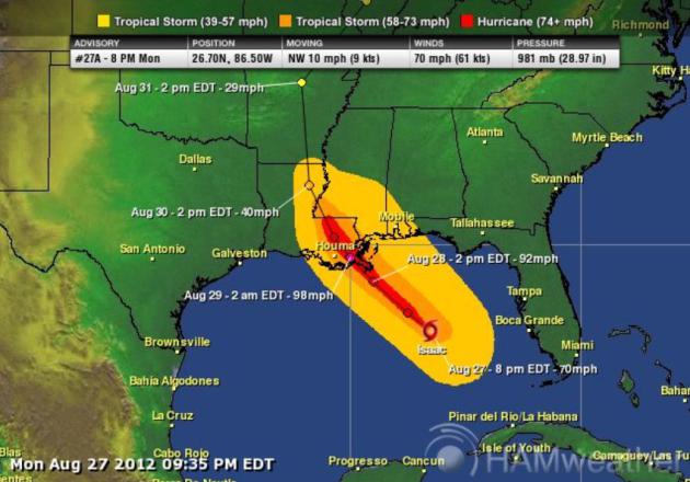
Monday PM Alerts Broadcaster “Isaac” Update
* Isaac finally achieving hurricane status over the Gulf of Mexico; intensifying rapidly.
* Landfall over coastal Louisiana likely Tuesday afternoon.
* Models hinting at very rapid strengthening; growing possibility of Category 2-3 strength before landfall.
* WRF model (below) suggests a 958 mb. hurricane before landfall, which could translate into 110-125 mph. sustained winds.
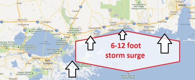
* Rapid
spin-up over northern Gulf of Mexico may limit storm surge (slightly),
but some abrupt 6-12 foot rises in ocean water levels are possible to
the right/east of where Isaac comes ashore.
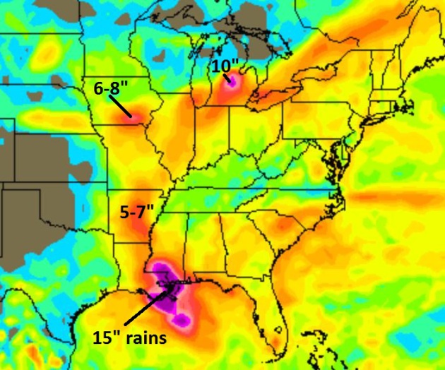
* 10-20”
rainfall amounts likely over Louisiana (including New Orleans), with a
band of 5-10” possible Wednesday thru Saturday in an arc extending from
Little Rock and Memphis to St. Louis. Some 10” amounts are possible as
far north as central Michigan by the weekend.
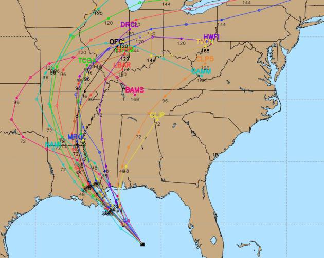
Isaac’s Track. There’s
now little doubt that Isaac will come ashore Tuesday afternoon/evening
along the southeastern coastline of Louisiana. The only question is a).
how strong, and b). how high will the storm surge go. Computer models do
a much better job with hurricane tracks than intensity, and Isaac is
particularly problematic. Unusually warm ocean water (82-85 F) in the
top 100 yards of water in the Gulf, coupled with light winds (little
wind shear) aloft may create conditions necessary for very rapid
intensification 12-18 hours before landfall.
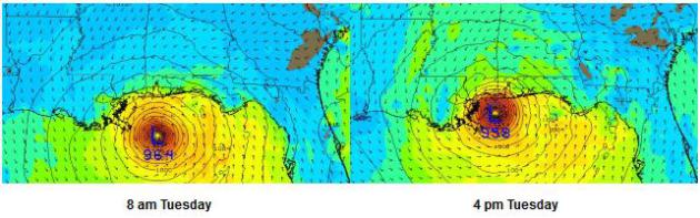
WRF Solution. In
general, the higher the resolution the computer model, the better it
tends to do with intensification. The WRF is a much more granular
simulation than the (global) GFS model, and for this reason I’m putting
more stock in the outcome (above). If Isaac does strengthen into a 958
mb hurricane it would imply a strong Category 3 hurricane with 110-125
mph winds before landfall, increasing the potential for extensive damage
and an extreme storm surge exceeding 10-12 feet to the right/northeast
of where Isaac comes ashore. The only saving grace: Isaac is a fairly
compact storm: hurricane-force winds may impact a 100-200 mile wide area
of eastern Louisiana and extreme southern Mississippi, near Bay St.
Louis, Gulfport and Biloxi. Mobile, Alabama may experience a 4-6 foot
storm surge during the day Tuesday.
Damage Swatch from Isaac. Although
tropical storm force (39 mph+) winds will impact an area roughly 300
miles wide, the band of hurricane-force winds will be much narrower,
closer to 100 miles wide.
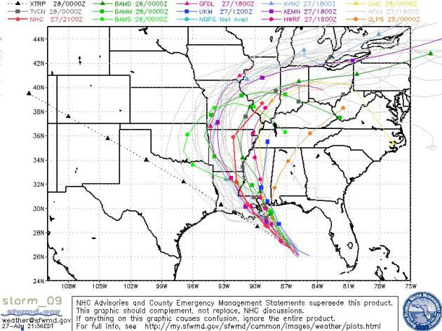
Ensemble Track Outlook. There is
still a fairly divergent outlook for the track of Isaac after it comes
ashore later in the day Tuesday, but the consensus/average track would
put Jackson, Shreveport, Little Rock, Memphis, Kansas City, St. Louis
and even Chicago in the path for potentially heavy rain. Hurricane-force
winds are unlikely north of the Louisiana/Arkansas state line, but
extreme (6”+) rains may result well inland, 1-4 days after Isaac comes
ashore. Do not underestimate the risk posed by inland flooding.
Significant Risk of Inland Flooding. Last year
the worst damage from “Irene” didn’t come from the storm surge or high
winds along the New England coast, but extreme flooding (over Vermont),
2-3 days after Irene came ashore. Historic rainfall was aided by
mountainous terrain over interior New England, which we obviously don’t
have to worry about with Isaac. But 15”+ rains are likely over the
parishes of Louisiana, with an arc of 5-8” rainfall possible from Little
Rock into southern Iowa, the Chicagoland area, Indianapolis, even
portions of lower Michigan.
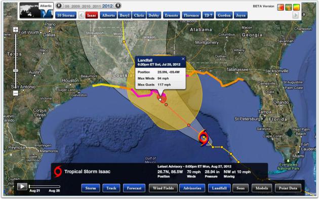
Landfall.
Alerts Broadcaster software is calculating first landfall of Isaac’s
“eye-wall”, the donut-shaped swirl of most violent winds rotating around
the eye, around 6 pm Tuesday, with sustained winds of 94 mph. and gusts
to 117 mph. I suspect the actual wind speeds will be at least 10 mph.
higher than those numbers.
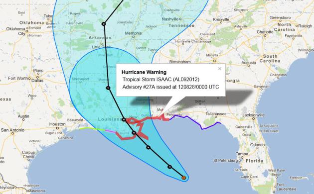
Hurricane Warnings. NOAA has
issued warnings (implying mandatory evacuations from coastal areas) from
Morgan City, Louisiana to the Alabama/Florida border. The threat has
eased for the Florida Panhandle. Again, the greatest risks are a). storm
surge, b). inland flooding, and c). wind damage, in that order.
High Threat Area. The
greatest concern from Isaac is from metro New Orleans to Slidell, Bay
St. Louis, Gulfport, Biloxi and Pascagoula, with a smaller risk for the
Mobile area. The most extreme flooding will come south of Interstate 10.
Barrier islands are most at risk. The worst conditions will come from
Tuesday afternoon into Wednesday morning, with gradual improvement
Wednesday afternoon. Widespread power outages are likely from New
Orleans to Biloxi with sporadic outages as far east as Mobile.

Summary. No hype or
spin: this is a very difficult forecast. I’m confident the track will be
over Louisiana, with the greatest impacts from New Orleans to Biloxi.
What is unclear is intensity. Odds favor landfall as a Category 2
hurricane, but there is a 1 in 3 (and growing) risk that Isaac could
grow into a (major) Category 3 hurricane. By comparison, Katrina was a
Category 4 as it pushed ashore on August 29, 2005. I don’t expect Isaac
to be as extreme as Katrina, but if the storm intensifies into a strong
Category 2 or Category 3 hurricane, damage will be extensive. The impact
on New Orleans is still unclear: the retrofitted levee system is good
to Category 4 (at least on paper). This will be the acid test of the
repairs and improvements. At this point there is simply no way to
predict impacts on New Orleans, but at this point, based on a variety of
factors, I do not expect a rerun of 2005’s historic storm, which left
1,800+ dead and damage over $81 billion.
Another Isaac summary Tuesday morning. Good luck.
Paul
Paul Douglas
Senior Meteorologist
Alerts Broadcaster
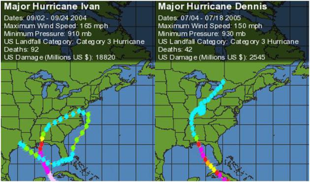
Tornadoes From Northern Gulf of Mexico Hurricanes And Tropical Storms.
The threat of Isaac spinning up tornadoes over the next 2 days as it
comes ashore is significant; here's an excerpt of a timely post from
ustornadoes.com: "..
What
we know is that since 1995 no hurricane making landfall from Louisiana
to the Florida panhandle produced fewer than 11 tornadoes in its life,
including post-landfall while the system remained an identifiable and
separate mid-level entity. Extending into northeast Texas, only
Humberto, a small Hurricane that developed along the coast rapidly
before landfall, provided numbers of tornadoes that were not at all
noteworthy with two. Stronger hurricanes have also tended to cause the
most tornadoes during the period, though that’s not a hard rule to live
by. Some tropical storms like Allison (2001) and Bill (2003) spawned
more recorded tornadoes than a number of their much stronger siblings."
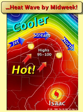
Midweek Heat Wave. As the jet stream lifts north,
desert heat will expand northward across the Plains, pushing the mercury
close to 100 F. by Thursday afternoon. Impressive, considering the sun
is as high in the sky now as it was back in mid-April. Details from the
local
National Weather Service.
Excessive Heat Watch. Thursday will bring back
memories of mid-July, a few models hinting at 95-100 F. highs in the
metro area. Dew points will probably be in the 50s to near 60, so it
won't feel quite as oppressive as it did 4-5 weeks ago. That said, 100
F. (even with low humidity) is plenty hot. Details from the local
NWS Office: "The National Weather Service in the Twin Cities/Chanhassen
has issued an Excessive Heat Watch...which is in effect from Thursday
morning through Thursday evening.
* Temperatures...highs Thursday afternoon will be near 100 degrees.
* Impacts..temperatures this warm can be dangerous for individuals
spending excessive time outside or within non air conditioned buildings.
Another Heat Spike. Thursday may be the hottest day
of the week, possibly the hottest day of August, with a good shot at
breaking through the triple-digit mark by late afternoon. Best case?
Mid-90s. Worst case: 100-103 F. highs in and around the MSP metro.
Graphic: Iowa State.
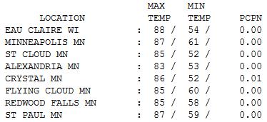
Another Magnificent Monday. I've lost count how many
(perfect) Mondays we've enjoyed this summer. Add another blue-sky,
postcard-perfect Monday to the growing tally. Under blue sky highs
ranged from 83 at Alexandria to 85 St. Cloud, 87 in the Twin Cities and
88 at Eau Claire.
Paul's Conservation Minnesota Outlook for the Twin Cities and all of Minnesota:
TODAY: Warm sun. Dew point: 60. Winds: SE 10. High: 87
TUESDAY NIGHT: Clear and mild. Low: 68
WEDNESDAY: Summer rerun. Hot sun. Dew point: 59. High: 93
THURSDAY: EXCESSIVE HEAT WATCH. Hints of July. Sizzling sun with a heat spike. Dew point: 51. High: 97
FRIDAY: Very slight relief. Sunny & dry. Low: 68. High: 89
SATURDAY: Hotter day of the weekend. Sticky. Dew point: 61. Low: 69. High: 92
SUNDAY: Cooler, stray T-shower possible, then slightly cooler and less humid. Dew point: 54. Low: 68. High: 84
MONDAY: Sunny, still warmer than average. Low: 66. High: 87
The Big Uneasy
For storm-weary residents of New Orleans it's
deja vu, all over again. 7 years ago tomorrow Hurricane Katrina came
ashore as a Category 4 super-hurricane, triggering $81 billion in damage
- killing more than 1,800 people - making it America's deadliest
hurricane since 1928.
Even today many Louisiana residents complain of the weather equivalent of PTSD, post traumatic stress disorder.
Isaac comes ashore later today, conditions ripe
for a Category 1 or 2 hurricane, not nearly as extreme as Katrina, but
worthy of respect (and evacuations away from the coastline).
Wind and waves get most of the national media
attention (everyone hoping for their "Dan Rather moment"; clinging to a
light pole while screaming into the microphone), but last year Irene
sparked historic flooding in Vermont, 2-3 days after landfall &
hundreds of miles inland. Isaac may ease drought conditions over the
Mississippi River Valley.
Our big story is more extreme heat. Although not
as sauna-like as July, at least one weather model is hinting at 100F by
Thursday. More 90s are likely into Saturday, but dew points from 55-60F
should make the heat more tolerable.
Photo credit above: "A steady stream
of cars head north on I-10 leaving New Orleans, Louisiana, in advance of
Tropical Storm Isaac on Monday, August 27, 2012." (Carolyn Cole/Los Angeles Times/MCT)
Climate Stories...
Hurricane Fact Sheet. My thanks to Jeff Nesbit and
Climate Nexus for passing this timely information along:
"Global warming is already affecting hurricanes, loading them with additional moisture, making for more intense rainfall.[i]
Hurricanes Katrina and Ivan, for example, carried significant increases
in rainfall due to climate warming, and in the case of Katrina the
increase may have contributed to the breach of the levees in New
Orleans.[ii]
NOAA reports that the record-breaking rainfall dumped by
Hurricane Irene was the main impact of the storm in the United States,
where flooding and other damage totaled over $15 billion.[iii]
Substantial
evidence also indicates that global warming may be responsible for the
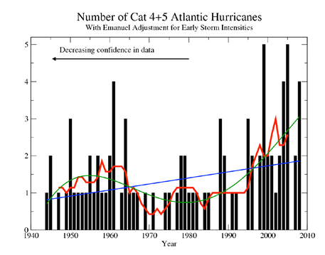
recent increasing intensity of Atlantic hurricanes,[iv] increasing their size[v] and contributing to a lengthening hurricane season.[vi] Out
of the 11 most intense North Atlantic hurricanes ever recorded, five
have occurred in the last eight years (Wilma, Rita, Katrina, Dean and
Ivan).[vii]
Atlantic hurricanes have grown stronger in recent years, a pattern
consistent with climate change. Annual sea surface temperatures in the
main Atlantic hurricane development region have increased nearly 2°F
since the 1970s, providing an ideal source of energy for hurricane
growth.[viii] According to data from 2007, the number of category 4 and 5 hurricanes has increased by nearly 75% since 1970.[ix] However, the incomplete historical record makes it difficult to confidently assess the nature of these trends.[x]
Beyond these changes, hurricanes storm surges now ride
higher upon coastal seas that have risen over the last century due to
global warming, amplifying losses where the surge strikes.[xi]"
Some key facts on hurricanes and climate change:
· "Of
the 11 most intense North Atlantic hurricanes ever recorded, five have
occurred in the last eight years (Wilma, Rita, Katrina, Dean and Ivan).[xii]
· The
record-breaking rainfall dumped by Hurricane Irene in 2011 was the main
impact of the storm in which flooding and other damage totaled over $15
billion.[xiii]
· Hurricane Katrina remains the costliest weather-related disaster on record (over $100 billion).[xiv]
· Tropical
cyclone Debby in June 2012 produced record-breaking rainfall across
Florida, in some locations dropping over 20" of rain in 24 hours.[xv] When Tropical Storm Debby formed on June 23, it was the first time ever that four storms formed before July since record keeping began in 1851.[xvi]"
Arctic Ice Reaches Record Low, Could Worsen Global Warming. Here's an excerpt from
The Christian Science Monitor: "
Arctic
sea ice, the white cap that covers the watery northern edge of the
planet, has melted back to a record low level. However, the ice is
unlikely to stop shrinking. Arctic sea melts through
the summer usually reaching its annual minimum in September. On Sunday
(Aug. 26), Arctic sea-ice extent fell to 1.58 million square miles
(4.10 million square kilometers), surpassing the previous low, set on
Sept. 18, 2007, the U.S. National Snow and Ice Data Center (NSIDC)
reports. Sea-ice extent refers to the area of ocean covered at least 15
percent by sea ice, according to the NSIDC."
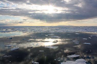
Photo credit above: "
Sea ice in the Chukchi Sea, on July
20, 2011. Scientists are setting out to conduct the first comprehensive
study of marine life in the Chukchi Sea." NASA/Kathryn Hansen
* The New York Times has more on the new record Arctic ice minimum
here.
Climate Change: An Information Statement From The AMS (American Meteorological Statement). This
HTML statement from AMS was released on Monday; here's an excerpt: "...
There
is unequivocal evidence that Earth’s lower atmosphere, ocean, and
land surface are warming; sea level is rising; and snow cover,
mountain glaciers, and Arctic sea ice are shrinking. The dominant cause
of the warming since the 1950s is human activities. This scientific
finding is based on a large and persuasive body of research. The
observed warming will be irreversible for many years into the future,
and even larger temperature increases will occur as greenhouse gases
continue to accumulate in the atmosphere. Avoiding this future warming
will require a large and rapid reduction in global greenhouse gas
emissions. The ongoing warming will increase risks and stresses to
human societies, economies, ecosystems, and wildlife through the 21st
century and beyond, making it imperative that society respond to a
changing climate. To inform decisions on adaptation and mitigation, it
is critical that we improve our understanding of the global climate
system and our ability to project future climate through continued and
improved monitoring and research. This is especially true for smaller
(seasonal and regional) scales and weather and climate extremes, and
for important hydroclimatic variables such as precipitation and water
availability."


No comments:
Post a Comment