By Paul Douglas
"It is best to read the weather forecast before praying for rain" said Mark Twain. And no, you can't please all the people all the time. Don't waste your breath. Farmers & gardeners want rain, the rest of us want to nibble at our alligator-on-a-stick out at the State Fairgrounds without having to do the backstroke in the parking lot.
According to the Drought Monitor 52 percent of Minnesota is abnormally dry; 36 percent of the state in a moderate drought or worse. Yes, it's hard to whine about rain, even on a Saturday. An eastbound front sparks a few hours of showers and T-storms today; not an all-day washout, but have a Plan B.
Winds shift to the northwest tomorrow, the sun returns with dropping dew points and low 80s. A more lake-worthy day. No puffs of late September this week; highs in the 80s to near 90 by late week. The next chance of storms? Next weekend.
While we wrestle with umbrellas residents of Florida are keeping a wary eye on Isaac. Coastal flooding is possible in the Naples/Ft. Myers area, but Tampa should avoid a direct hit. The Florida Panhandle may not be so lucky; 80-100 mph winds and a 4-8 foot storm surge possible there by Tuesday night. Stay tuned.
____________________________________________________________________________
Todd's Conservation MN Outlook for the Twin Cities and all of Minnesota
SATURDAY: Wetter day of the weekend. Unsettled start, chance for a passing shower or storm. Fading PM sunshine with more storms PM developing. High: 80
SATURDAY NIGHT: Showers and storms early, then clearing overnight. Dew points start to fall. Low: 65
SUNDAY: A little soggy to start, looking better through the day. More sunshine, not as sticky. High: 83
MONDAY: Nice stat! Fading PM sunshine, slight chance of a passing PM shower across far southern MN. Low: 61. High: 82
TUESDAY: Pleasant, nothing rough. More PM clouds. Low: 61. High: 85
WEDNESDAY: Mix of clouds and sun with showers/storms across far northern MN. Low: 65. High: 84.
THURSDAY: Quiet. Mild sun. Low: 66. High: 86.
FRIDAY: Another mild day, fading PM sun with a slight chance of thunder late. Low: 66. High: 82
_________________________________________________________________________________________-
Saturday, August 25th, 2012
Heading to the Fair Saturday? Stop by and
say hey! I'll be at the StarTribune booth from 12pm to 1pm. Paul Douglas
will make an appearance next weekend, stop by then too!

The Minnesota State Fair continues... Day 3! Saturday night, Blake Shelton comes to town with special guest Sunny Sweeney.
"Blake Shelton has been one of country
music's most compelling entertainers for more than a decade. With his
fiery attitude and versatile vocals, Shelton has produced countless
singles including "Austin," "Home," "All About Tonight" and "Hillbilly
Bone." His latest album, Red River Blue, has brought country music fans
the monster hits "Honey Bee," "God Gave Me You" and his current single
"Over." Most recently, Shelton finished his second season on NBC's hit
show "The Voice," where he led Team Blake member Jermaine Paul to
victory."

Best People Watching This Side of Vegas...
Thanks to Startribune.com you can people watch all you want from the LIVE webcam at the Fair!

Weekend Weather Outlook
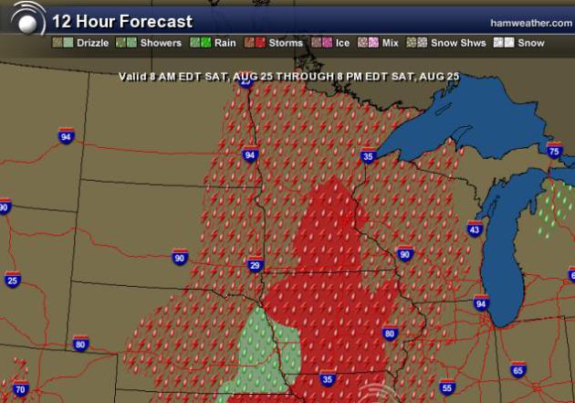
An approaching storm system will slide
through on Saturday with a chance of showers and thunderstorms. Saturday
most definitely looks like the wetter day of the weekend, have a plan B
or bring something waterproof if you plan on heading to the Fair.
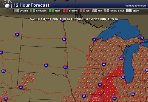
Sunday appears to be the nicer, drier day of the weekend as the front
slides east into Wisconsin.
Saturday Forecast 8AM-8PM
Sunday Forecast 8AM-8PM
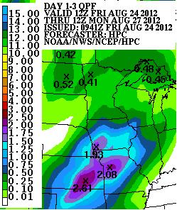
Weekend Rainfall
NOAA's rainfall forecast over the weekend
suggests UP TO 0.25" to 0.50" of rainfall across parts of the state with
most of the rainfall occuring on Saturday.
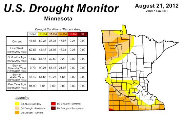
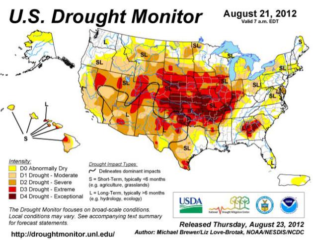
Drought Update
The US Drought Monitor released their
weekly update on Thursday. It shows that drought conditions have
worsened a little. Abnormally dry conditions went from 47% of the state
to 52% and severe drought conditions went from 16% to nearly 18%. These
'dry' areas are across the western and southern part of the state.
National Drought Update
"This U.S. Drought Monitor week saw a
few notable improvements and some serious degradation. Temperatures
have generally been below normal this week from the east side of the
Rockies to the East Coast, with the exception of Texas, the Southeast
Coast, and northern New England. This has helped ease drought impacts,
particularly in those areas where beneficial precipitation fell. One
such area is in the Ohio Valley where parts of Indiana saw more than
five inches of rain. This is the second straight week of beneficial
precipitation for some of these areas and this precipitation has largely
alleviated Exceptional Drought (D4) from the state, despite lingering
impacts still being felt. Last week, drought gripped slightly less of
the agricultural land in the country with 85% of the U.S. corn crop, 83%
of soybeans, 63% of hay, and 71% of cattle areas experiencing drought.
Nearly half of the corn (49%) and soybean (46%) areas are experiencing
Extreme (D3) to Exceptional (D4) Drought. This has led to both reduced
yields and earlier harvests. Additional impacts this week include
closing of an 11-mile stretch of the Mississippi River near Greenville,
MS to barge traffic because of low water levels and wildfires expanding
from northern California to Idaho."
PICTURE OF THE DAY
Not sure where this was taken, but I thought it was worth sharing! Pretty cool picture of a waterspout (tornado over water)

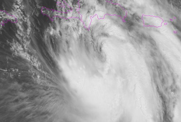
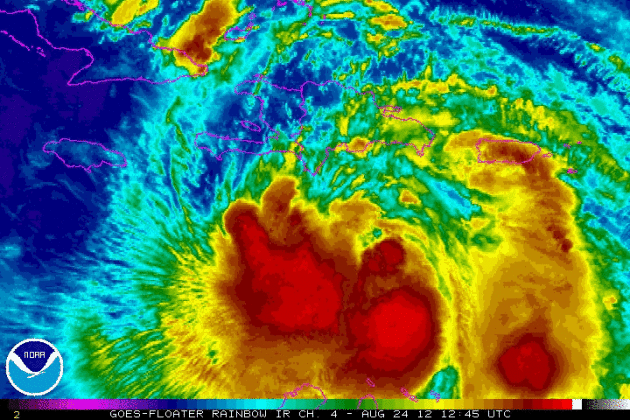
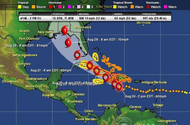
Eyes on Isaac
DISCUSSION AND 48-HOUR OUTLOOK
------------------------------
AT 200 PM EDT...1800 UTC...THE CENTER OF TROPICAL STORM ISAAC WAS
LOCATED NEAR LATITUDE 16.8 NORTH...LONGITUDE 71.4 WEST. ISAAC IS NOW
MOVING TOWARD THE NORTHWEST NEAR 14 MPH...22 KM/H..AND THIS GENERAL
MOTION IS EXPECTED TO CONTINUE FOR THE NEXT COUPLE OF DAYS. ON THE
FORECAST TRACK...THE CENTER OF ISAAC WILL APPROACH THE SOUTHERN
COAST OF HISPANIOLA THIS AFTERNOON...PASS NEAR OR OVER HAITI
TONIGHT...AND MOVE NEAR OR OVER EASTERN AND CENTRAL CUBA SATURDAY
AND SUNDAY.
MAXIMUM SUSTAINED WINDS ARE NEAR 60 MPH...95 KM/H...WITH HIGHER------------------------------
AT 200 PM EDT...1800 UTC...THE CENTER OF TROPICAL STORM ISAAC WAS
LOCATED NEAR LATITUDE 16.8 NORTH...LONGITUDE 71.4 WEST. ISAAC IS NOW
MOVING TOWARD THE NORTHWEST NEAR 14 MPH...22 KM/H..AND THIS GENERAL
MOTION IS EXPECTED TO CONTINUE FOR THE NEXT COUPLE OF DAYS. ON THE
FORECAST TRACK...THE CENTER OF ISAAC WILL APPROACH THE SOUTHERN
COAST OF HISPANIOLA THIS AFTERNOON...PASS NEAR OR OVER HAITI
TONIGHT...AND MOVE NEAR OR OVER EASTERN AND CENTRAL CUBA SATURDAY
AND SUNDAY.
GUSTS. SOME STRENGTHENING IS POSSIBLE BEFORE THE CENTER REACHES THE
COAST OF HISPANIOLA TONIGHT...AND ISAAC COULD BE NEAR HURRICANE
STRENGTH AT LANDFALL.
TROPICAL STORM FORCE WINDS EXTEND OUTWARD UP TO 185 MILES...295 KM
FROM THE CENTER.
THE ESTIMATED MINIMUM CENTRAL PRESSURE BASED ON A SHIP REPORT IS 997
MB...29.44 INCHES.
Check out this amazing satellite, which updates every minute!
Hard at Work... Gathering Data
NOAA's G-4 aircraft scheduled to fly a
synoptic surveillance mission on Friday, tookoff at 1730 UTC (1:30pm
EDT) from MacDill AFB. The G-IV crew sampled the subtropical ridge north
of Isaac as well as circumnavigating the storm. Here’s their track.

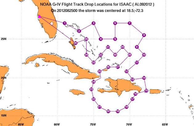
The crew of NOAA42 is back in FL, routine maintenance already underway. They will resume Isaac flights on Sunday.

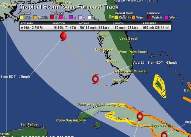
Latest Forecast on Isaac
The latest forecast track from the National
Hurricane Center bring Isaac into the Gulf coast late weekend/early
next week as a tropical storm. Hurricane status could be met by early
next week with sustained winds at 74mph+ as it nears the Alabama/Florida
coast. At this point, we could be looking at a landfall early Wednesday
morning.
Florida Keys Under the Gun Monday...?
The center of Isaac is forecast to move over the Florida Keys early Monday. This is already prompting closures along the Keys!
"The Village of Islamorada closes
Founders Park at 6 p.m. Saturday, including the pool, boat ramp and
Plantation Yacht Harbor Marina. The park will remain closed through
Sunday, and possibly longer depending on weather.
Islamorada municipal offices tentatively are scheduled to open
Monday, unless a change in expected storm conditions warrants closing.
That decision likely will be made Sunday.All areas of Everglades National Park closed at 8 p.m. Friday, and will remain closed until “the storm has passed and conditions are safe.”
The closure includes the Main Park Road, and all park and commercial operations at Flamingo. “These closures are conducted in the interest of public safety and to ensure park staff concentrates completely on securing and protecting park resources and facilities,” says a park notice."
Read more from KeysNet.com HERE:
Be Prepared!
Thanks to NOAA for the great
information! It's never too early to start thinking about taking acion
if you are path of the approaching storm.
Thanks for checking in, have a great rest of your weekend!
Don't forget to check me out on Twitter @TNelsonWNTV

No comments:
Post a Comment