Hurricane apathy
By Paul Douglas
By Paul Douglas
It's been 7 years since a major hurricane hit the USA (Katrina in 2005). Officials are increasingly worried about apathy. Instead of evacuating inland residents of threatened barrier islands decide to stay put, ride out the storm, take their chances. A hurricane party! Their worst fear: A Category 1 hurricane lulls people into a false sense of complacency. Overnight the hurricane explodes into a 3 or 4, but it's too late to evacuate the people who decided to stay put.
This nightmare scenario almost played out 1995. "Opal" mutated from a Category 1 to a 4 - overnight. At the last moment tens of thousands of Floridians jammed interstates. It was gridlock; people abandoning vehicles to reach higher ground on foot! A catastrophe was narrowly averted.
Isaac will probably take the westerly wobble I described yesterday: the ECMWF brings it into Louisiana, maybe Galveston, as a major hurricane late Wednesday. Florida should avoid the worst of the storm. Maybe they'll get the RNC in, after all.
No hurricanes on Lake Calhoun. We may hit 90 today; T-storms rumble in late Saturday. Sunday looks like the sunnier, drier day for the State Fair. Yes, I'm counting my (atmospheric) blessings.
___________________________________________________________________________________
Todd's Conservation MN Outlook for the Twin Cities and all of Minnesota
FRIDAY: Lingering shower/storm early? Warm, hazy PM sun . Dew point: 66. High: 88
FRIDAY NIGHT: Increasing clouds, Isolated showers/storms develop late. Low: 68
SATURDAY: Wetter day of the weekend. A few drips early? Fading PM sunshine with more storms developing. High: 83
SUNDAY: Stikcy start, looking better by late afternoon. Low: 64. High: 81
MONDAY: Nice day at the Fair! Comfortable AM sunshine with more PM clouds. Low: 62. High: 82
TUESDAY: Pleasant, nothing rough. Low: 62. High: 82
WEDNESDAY: Storm system blows through with a slight chance of rain/thunder. Low: 65. High: 85.
THURSDAY: Slight chance of a shower/storm up north. Low: 66. High: 85
_____________________________________________________________________________________
Friday, August 23rd, 2012
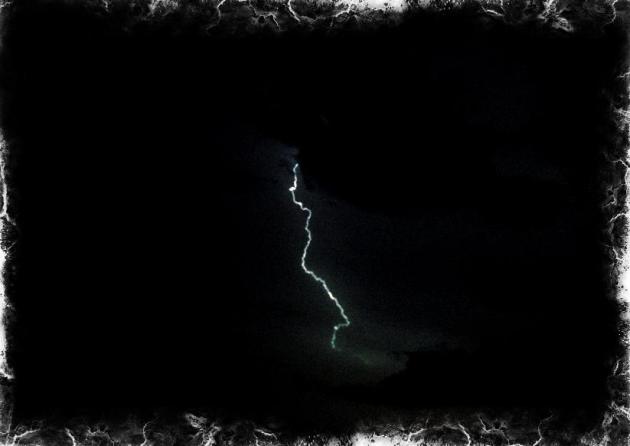
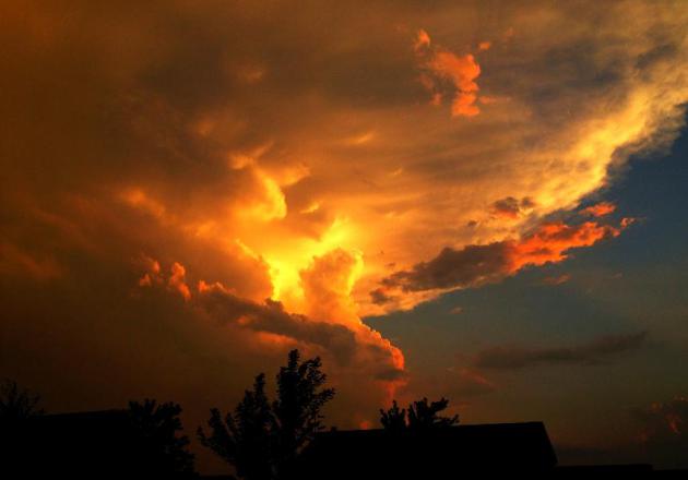
Scattered storms Thursday night seemed to be quite photogenic... I snapped these pictures below

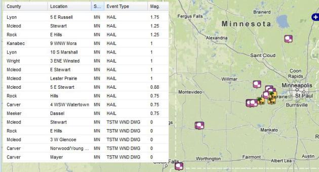
Storm Reports
The storms were also responsible for hail
and high wind just west of the Metro, below are some of the reports. One
of the more significant reports was from McCleod county: 3 NW
Glencoe [Mcleod Co, MN] law enforcement reports TSTM WND DMG at 08:43 PM
CDT -- roof partially off house. trees down. part of silo also blown
off. corrected location instead of 3w glencoe. See more from the SPC HERE:
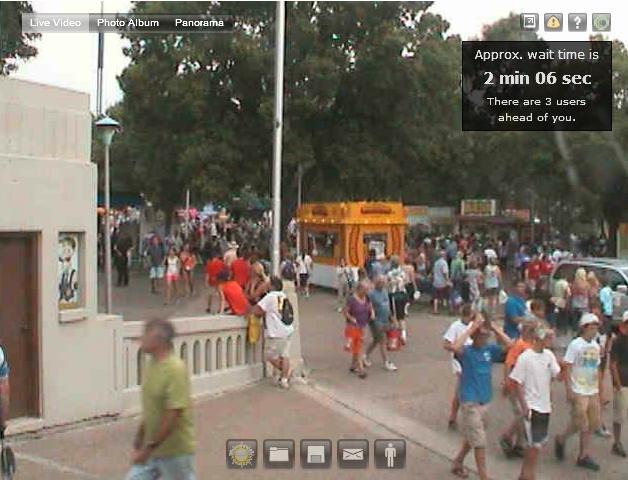
MN State Fair Day 2 of 12...
Thanks to the Startribune for the
LIVE webcam at the Minnesota State Fair! This could be fun... best 12
days of people watching this side of Vegas!
It's time once again
for the "Great Minnesota Get Together." Weather plays quite a role in
the State Fair experience. Who doesn't remember braving the heat with
the crowds on one of the busier intersections on a sweltering afternoon?
A quick rain burst will send people scurrying for cover, and folks
savor balmy days in the 70's with just a bit of a breeze. Below are some
State Fair weather facts and some interesting weather events that have
happened in past Minnesota State Fairs.
The Minnesota State Fair has been held
at its current site since 1885. There were some years when the fair was
not held because of war, disease or logistical reasons. These years are:
1861 (Civil War) 1862 (Civil and Indian War) 1893 (Columbian
Exposition) 1945 (fuel shortage because of WWII) and the last time the
fair was not held was in 1946 due to an outbreak of Polio. The fair has a
12 day run each year ending with Labor Day. Thus the fair begins on a
Thursday in August.
State Fair Weather Extremes:
Hottest Temp: 97F on September 1, 1913 and also August 24, 2003
Coldest Temp: 36F on September 1, 1974
Wettest Day: 4.06" on August 30, 1977
Wettest Fair: 9.48" in 1977
Driest Fair: 0.02" in 2003
On average it rains about 3 to 4 days during the 12 day stretch of the Fair!
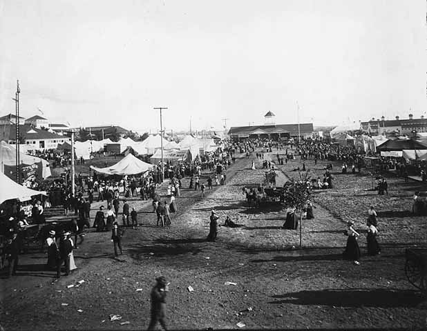
General Scene at the Fair Around 1900 - Courtesy: Minnesota Historical Society
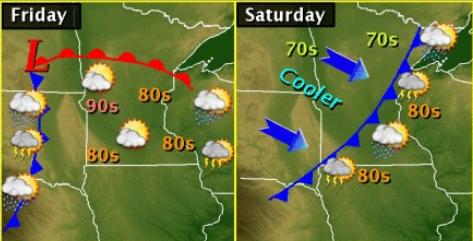
An approaching storm system today will
allow for warm and summery heat to settle into the region today. Temps
could spike to 90F in a few spots along with sticky dew points. Showers
and storms will develop along the cool front late Friday into Saturday. A
few strong rumbles of thunder can't be ruled out, but widespread severe
weather is not expected. Sunday will be the nicer, sunnier day of the
weekend as the front drifts east into the Great Lakes region.
(Photo courtesy: MPX NWS)
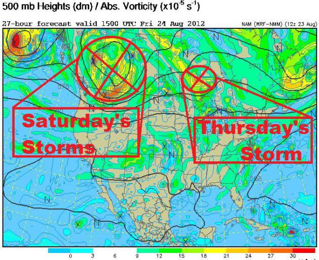
Short Waves
The strong upper level winds have turned a
little more westerly since last week, which has allowed the warmer, more
humid air to settle in. this is also a slightly more active pattern as
impulses of energy roll over the Rocky Mountains and bring us a chance
of rain/thunder. We had a weak storm roll through Thursday with areas of
showers/storms in parts of the state, now the next one is to our
northwest and will roll through Saturday.
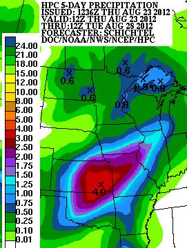
Getting Some Rain
NOAA's HPC 5 day rainfall forecast through
early next week suggests some rain for the Upper Mississippi Valley, but
not quite as much as what they could get across parts of the Central
Plains or the middle Mississippi Valley. Showers and thunderstorms there
could produce nearly 4" of rain during that time... GREAT NEWS! The
central part of the country is still dealing with EXTREME to
EXCEPTIONAL drought conditions.
NOAA satellites are keeping their “Eyes on
Isaac” as the storm churns across the Caribbean. An early Thursday
morning picture showed a little disorganization, but further development
is still expecting in the coming days.

NOAA Hurricane Hunters
Here’s another picture of Isaac from early
Thursday morning, but this is from INSIDE the storm. NOAA Hurricane
Hunters were not too impressed with the system as it appeared to try to
strengthen.

Eyes on Isaac
The satellite loop below shows stronger
thunderstorms near the center still trying to get something going… As
of early AM Thursday, there was still no eye evident.

An Active Atlantic
Not only are we talking about Isaac, but newly formed Joyce is hot on Isaac’s heels!
See more from the National Hurricane Center HERE:

Isaac and Joyce Updates
Tropical Storm Isaac continues to
remain somewhat disorganized, but conditions are becoming more
favorable and Isaac is still expected to intensify to a hurricane by
Friday night. Isaac will continue to move to the west across the
Caribbean before making a turn to the northwest by the weekend. There
is still considerable uncertainty regarding the track of Isaac, and
while the current forecast is
for the center of the storm to track
just off the west coast of Florida, Isaac’s impacts will likely be felt
across much of the Florida peninsula during Monday into Tuesday. For
the latest updates on Isaac visit the NOAA NWS National Hurricane
Center at http://www.hurricanes.gov/

More On Isaac – Isaac to Encounter Obstacles…
Take a closer look at the forecast track
of Isaac. One thing that will likely inhibit sufficient development on
Isaac is the higher terrain of Hispaniola and Cuba. Note the forecast
prior to making landfall with Hispaniola (hurricane force), then
dropping down to a tropical storm strength and only a short trip across
more water before making a potential landfall with Cuba. However, if
the current forecast holds, there will be little impact by land as
Isaac works into the warm waters of the Gulf of Mexico. Rapid
development could occur if everything is right, but at this point,
Isaac is forecast to remain a category 1 hurricane hurricane as it
slides along the west coast of Florida. Still lots of time for things
to change, so stay tuned!
See more from the National Hurricane Center HERE:

A General Consensus
Keeping in mind that there are several
models and several different outcomes, the models listed below seem to
agree that Isaac will travel very close to southern Florida, by late
weekend/early next week.

GFS Solution
The NHC forecast track (White line above)
follows that of the GFS (Red line above) very closely. The image/loop
below is the 06Z GFS run through next week.

Heavy Rain to Impact Florida
According to latest model runs, Florida
will get exceptionally heavy rainfall late weekend/early next week.
NOAA’s HPC AM Sunday-AM Tuesday rainfall forecast suggests 4″ to 6″ +
across parts of central and southern Florida.

2nd Wettest Day in Las Vegas EVER!
Thanks to @DanOBrienPoker for the picture out of Las Vegas, NV where on Wednesday 1.65″ of rain fell.

Not only was that a record rainfall for
August 22nd, but it also became the 2nd wettest day ever on record!
Interestingly, the wettest day in Las Vegas’ history happened almost on
the same day… 8/21/12 with 2.58″ Goes to show you that we typically see
our heaviest rainfall (precipitation) at this time of the year
(monsoon season)!

Thanks for checking in on this Thursday, have a great rest of your week!
Don’t forget to follow me on Twitter @TNelsonWNTV

No comments:
Post a Comment