75 F. high on Monday in the Twin Cities.
79 F. average high for August 20.
76 F. high on August 20, 2011.
-1.6 F. August temperatures are 1.6 F. cooler than average for the month, to date.
 15,000
 members of the media gathered in Tampa for
next week's RNC, The Republican National Convention? Talk about a
target. What can possibly go wrong?
1946: last time Tampa saw a direct hit from a hurricane.
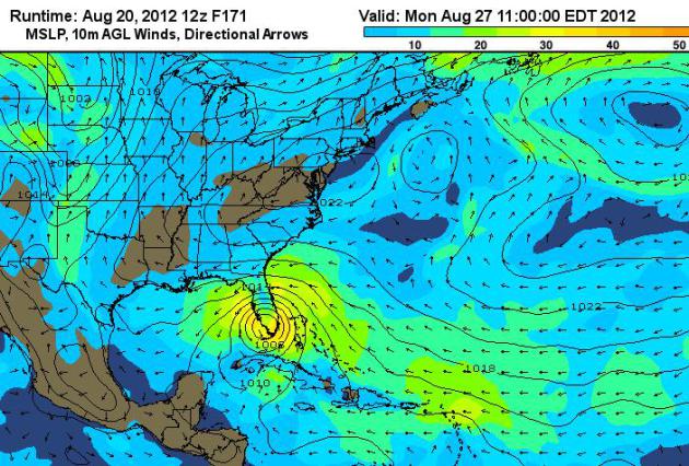
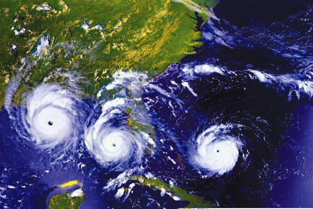
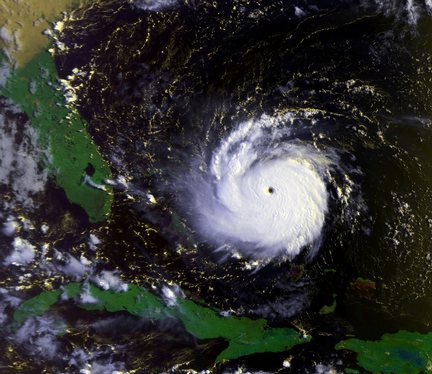
Hurricane Isaac? O.K. This system is nearly a week
away from threatening the U.S. mainland, but with the Republican
National Convention kicking off next Monday in Tampa, what can possibly
go wrong? Organizers have been paranoid about a possible hurricane
impacting the Tampa-St. Pete area for years now, and there is a 1 in 3
chance their worst fears may come true. The track will almost certainly
change over time, as new data initializes the computers and each
successive computer run fine-tunes the path of this storm. Wind shear
over the Caribbean may shred the storm, preventing it from intensifying.
Bottom line: it's too early to tell. But if you have friends in Florida
you may want to encourage them to pay attention in the coming
days...just in case. GFS model above courtesy of Ham Weather.
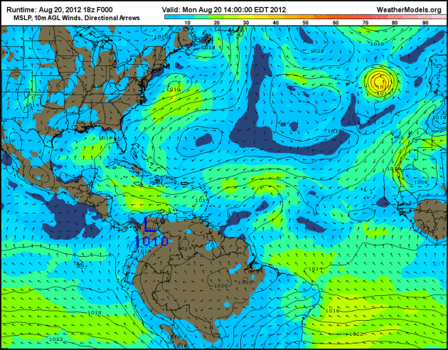
Watching The Tropics. Here is the GFS model, showing
gradual intensification of a tropical wave as it passes south of Cuba,
turning north toward Florida late in the weekend and early next week.
Too early to panic, but we are overdue for a land-falling tropical storm
or hurricane.
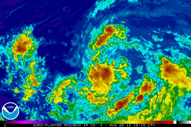
Getting Organized. NOAA's
enhanced IR loop
shows the circulation of "94L" becoming better organized over time -
there's a chance this westward-tracking tropical wave may strengthen
into Tropical Storm Isaac as early as today.
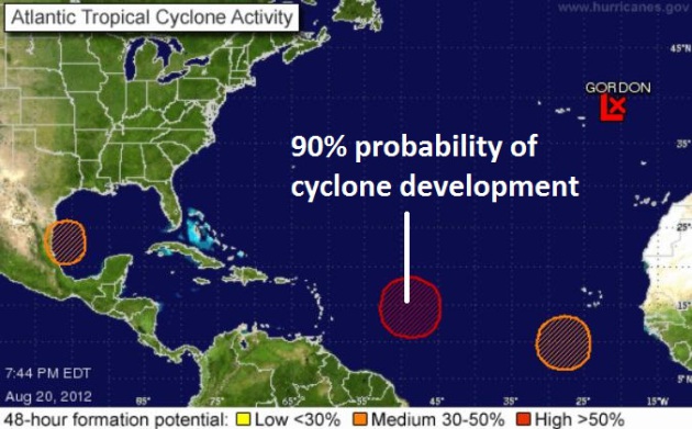
Tropics Becoming More Active. After an extended lull
we're seeing a conga-line of tropical systems in the Atlantic. The
system east of the Lesser Antilles has a 90% probability of becoming a
tropical storm. Map:
NHC.
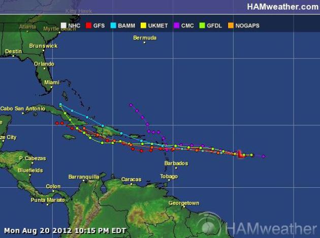
Projected Track. Continuity is fairly strong, a
tight grouping of predicted paths for what may shortly become "Isaac".
Will Isaac's storm impact the USA? Too early to tell. A path over the
Dominican Republic and Cuba would limit intensification, robbing the
storm of some of it's energy (derived from warm ocean water). Map
courtesy of Ham Weather.
Republicans Prepared For Long-Shot Hurricane At Tampa Convention.
The odds of a hurricane strike are still small (but growing with each
passing computer run). No, you just can't make this stuff up. Here's an
excerpt from an article at
Bloomberg Businessweek: "
Four
years after a hurricane in Louisiana forced Republicans to make changes
to their convention 1,300 miles away in Minnesota, they’ll nominate
their next presidential candidate in Florida, among the most hurricane-
prone states in the country. Few hurricanes have hit Tampa, home to the
Republican National Convention that starts Aug. 27, and odds are low it
will happen during the four-day event when the party nominates Mitt
Romney as its challenger to Democratic President Barack Obama. In one
projection, a low-pressure system moving across the Atlantic develops
into a tropical storm and makes landfall in Tampa during the convention,
said Jeff Masters, founder of the Ann Arbor, Michigan-based Weather
Underground. Meteorologists say predictions are unreliable more than a
week in advance."
Mississippi River: Closed Until Further Notice. From a
USA Today article: "
The
U.S. Coast Guard says 97 boats and barges are waiting for passage
along an 11-mile stretch of the Mississippi River that has been closed
because of low water levels."
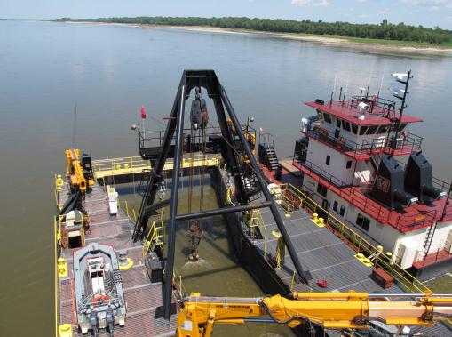
Photo credit above: "
A winch and a crane keep a dredging
apparatus steady as it sucks up sand from the bottom of a navigation
channel on the Mississippi River on Monday, Aug. 20, 2012 near Memphis,
Tenn. The Mississippi River from Illinois to Louisiana has seen water
levels plummet due to drought conditions in the past three months. Near
Memphis, the river level was more than 12 feet lower than normal for
this time of year." (AP Photo/Adrian Sainz)
Drought Exposes Sandbars Along Rivers, But Experts Warn Of Quicksand-Like Problems. Quicksand, along the banks of the Mississippi River? Good grief. Here's an excerpt from
The Washington Post: "
A
lack of rain in the United States’ midsection in recent months has
reduced water levels in some of the nation’s biggest rivers, exposing
sandbars that experts warn could be deadly quicksand. Rivers such as the
Mississippi and Missouri are typically low in August, but this year’s
drought has them at their lowest point in decades. The sandbars that
are revealed look like beaches, inviting boaters, fishermen and hikers
to venture out. Experts agree that can be a very bad idea."
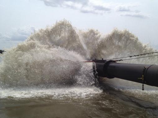
Photo credit above: "
A plume of water at the end of the
discharge pipe aboard the Dredge Potter on the Mississippi River near
St. Louis, Aug. 17, 2012. The river is affected by the ruinous drought
across much of the Midwest, with some stretches nearing the record
low-water levels experienced in 1988." (John Schwartz/The New York Times).
827 cooling degree days since June 1.
575 average number of cooling degree days from June 1 - August 18.
44% energy consumption to cool our homes and businesses is running nearly 44% above average since June 1. Source:
Twin Cities National Weather Service.
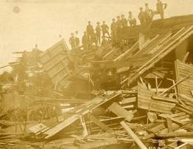
108 Year Anniversary Of St. Louis Park Tornado. From the St. Louis Park Historical Society: "
On
this date in 1904, Saint Louis Park, and the downtown’s of Minneapolis
and Saint Paul were hit by tornadoes. This was the highest official
wind ever recorded in Minnesota over one minute (110 mph in Saint
Paul). Photo from the St. Louis Park Historical Society."
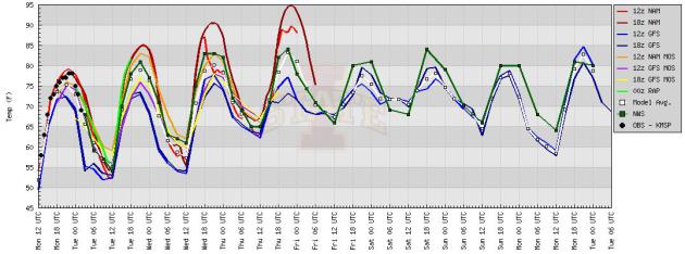
Warming Trend. The models are in fairly good
agreement, showing a warming trend into Friday. 90 F. isn't out of the
question by late week, but mid-80s seem more likely the latter half of
the week, running 5-8 degrees above average.
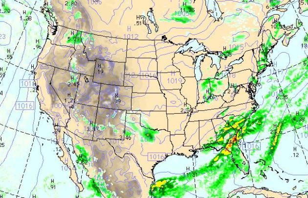
Today's Weather Map. The WRF model, valid 4 pm
today, keeps a stationary front draped over the southeastern USA, with
more flash flooding for the Panhandle of Florida into South Carolina; a
few spotty instability late-day showers over the Ohio Valley and the
Dallas area. Otherwise most of America looks dry.
 ECMWF: A Drier Solution
.
The latest European run isn't nearly as wet for the weekend, especially
Sunday. Earlier runs suggested that a weak, eastbound cool front might
stall close to MSP, sparking a period of more significant rain. A few
T-showers are possible Wednesday into Thursday as warmer air approaches,
mid-80s likely the latter half of the week. Saturday still appears to
be the warmer day (mid to upper 80s possible), but the odds of
significant rain have diminished a bit for Sunday - no significant rain
until Wednesday of next week.
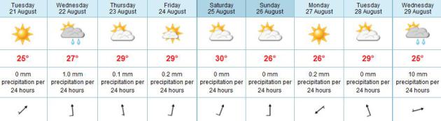
State Fair Weather: A Historical Perspective.
The odds are in your favor (of dry weather) if you're heading to the
State Fairgrounds in Falcon Heights. Here's an excerpt from
The Minnesota Climatology Working Group: "..
The Minnesota State Fair has been held at its current site since 1885.
There were some years when the fair was not held because of war, disease
or logistical reasons. These years are: 1861 (Civil War) 1862 (Civil
and Indian War) 1893 (Columbian Exposition) 1945 (fuel shortage because
of WWII) and the last time the fair was not held was in 1946 due to an
outbreak of Polio. The fair has a 12 day run each year ending with Labor
Day. Thus the fair begins on a Thursday in August. The State Fair in
2010 runs from August 26 to September 6. Temperatures can be highly variable as the summer begins to slip away.
The sun is already setting about an hour earlier than it did in June.
The average high temperature during the fair is in the mid to upper 70's
with the average low temperature in the upper 50's to low 60's. There's
been some extreme heat during the fair with 97 degrees on September 1.
1913 and also August 24, 2003. The coolest fair was 36 degrees on
September 1, 1974. On average it rains about 3 to 4 days during the fair's 12 day run. The
wettest fair was in 1977 with 9.48 inches, and the driest fair was 2003
with only .02 inch of rain."
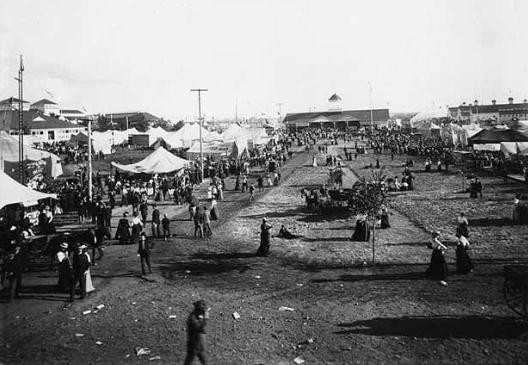
Photo credit above: Minnesota State Fair, circa 1900. Courtesy: Minnesota Historical Society.
A Minnesota State Fair App? Hey, why not. What caught my eye about the
State Fair App
(other than making it easy to find the Grandstand entertainers you
really want to see...is a feature to track down new heart-healthy foods
on a stick. I tried it, and slobbered all over my iPhone. Not good. The
fair kicks off Thursday. How is that possible?
“
The late-day pasting-on of revenue programs to pretty products
makes monster hybrids, and that just makes a lot of Dr. Frankensteins
sad. It’s a little galling after they’ve all made it clear just how
revolting they find advertising to find them circling back around
later.” - from a gigaom.com article below focused on the challenge
of successful advertising business models in a world increasingly
composed of social media streams of data.
The Cost Of Cool. I'm feeling better about my busted
A/C unit. It's a fact of life: human productivity seems to suffer when
air temperatures exceed 78-80 F. People tend to become easily
distracted. As the planet warms more people (worldwide) are turning on
air conditioners, which requires more electricitiy, more burning of
fossil fuels to keep people comfortable, which releases more emissions
which warm up the atmosphere even more. Another unpleasant "feedback
effect" which has scientists concerned. Here's an excerpt of an article
at
The New York Times (subscription may be required): "
Fact
3: Scientific studies increasingly show that health and productivity
rise significantly if indoor temperature is cooled in hot weather. So
cooling is not just about comfort. Sum up these facts and it’s hard to
escape: Today’s humans probably need air-conditioning if they want to
thrive and prosper. Yet if all those new city dwellers use
air-conditioning the way Americans do, life could be one stuttering
series of massive blackouts, accompanied by disastrous planet-warming
emissions. We can’t live with air-conditioning, but we can’t live
without it."
A Little Close For Comfort. Details from the New Orleans office of the
National Weather Service: "
A
fire started by a lightning strike broke out at a chemical facility in
Belle Chase yesterday was caught on camera. This picture shows the
importance of seeking shelter indoors when lightning is striking around
you!!"
Remembering The Flood Of 2007: Repairs To City Cost $40 Million; $1.4 Million In FEMA Money Undelivered. 5 years ago Rushford, Minnesota was inundated by an historic flash flood.
The Winona Daily News has a follow-up on the flood, aftermath and recovery - here's an excerpt: "
RUSHFORD,
Minn. —The city aged about 50 years in a few days in August 2007. The
flash flood left parts of Rushford underwater for days and damaged much
of its public infrastructure. The city has spent nearly $40 million
since on recovery projects. The result: Most things in Rushford are new.
“They say sometimes it takes a flood to clean up a town,” said Jeff
Copley, the city’s public works director.
Long road to recovery
The city has slowly made its way through a long list of repair
and rehabilitation projects. Many costs were covered by FEMA or state
grants or donations, but the city paid its share, too. The city spent
$4.2 million, split between a loan and bonds, on a 2009 street, water,
sanitary and sewer repair project."
NASA Drones To Investigate Hurricanes.
Meteorologists do a good job predicting the track of hurricanes, but
forecasting hurricane intensity is still very problematic. Our biggest
fear? A Category 1 hurricane just offshore mutates into a Category 4 or
5, virtually overnight. All those coastal residents who decided to stay
put, because it's "only a category 1" wake up to a monster, and there's
no way to get everyone off the barrier islands in time. That's why
unmanned drones may help to revolutionize hurricane research, doing what
no manned aircraft can do. Details from
satnews.com: "
NASA's
Hurricane Severe Storm Sentinel Mission, or HS3, will be studying
hurricanes at the end of the summer, and there will be two
high-altitude, long-duration unmanned aircraft with different
instruments flying over the storms...Using unmanned aircraft has many
advantages. Hurricanes present an extreme environment that is difficult
to sample. They cover thousands of square miles in area, and can also
extend up to 50,000 feet in altitude. Second, they involve very high
winds, turbulence and heavy precipitation. Third, ground conditions
(high winds that create heavy seas or blowing materials) make surface
observations difficult."
Photo credit above: "
NASA's Global
Hawk No. 871 cruises over low cloud layers above the Dryden Flight
Research Center on Edwards Air Force Base, Calif. This was the first
Global Hawk built in the original Advanced Concept Technology
Demonstration program, joining NASA's other Global Hawk, No. 872, for
high-altitude, long-endurance environmental science missions." (NASA/Lori Losey)
20 Years Later: The Children Of Hurricane Andrew.
Many Floridians were understandably traumatized by Category 5 "Andrew",
which swept ashore with 200 mph. wind gusts on August 24, 1992.
CBS Miami has the story of children who survived the storm, but now have life-long anxieties; here's an excerpt: "
Surviving
Hurricane Andrew was traumatic for most of those who lived through it,
but especially for the children of Andrew who lost some of their
innocence in the storm. In the months and years after the hurricane,
some would run for cover in their homes when thunderstorms struck while
others would have nightmares of another hurricane threatening South
Florida. Dante Diaz had just turned 9-years old and lived in Cutler
Ridge when Hurricane Andrew roared across South Florida on August 24,
1992. Diaz said it took him many years to desensitize from sudden surges
of wind, and bad thunderstorms. Annie Lofredo was 10-years old and
lived in East Kendall near the Falls. She described her experience with
Andrew as powerful. “It also showed me how quickly everything can change.” Hurricane Andrew time lapse sequence courtesy of NASA.
Hurricane Andrew: Had Enough Tropical Terrors' For A Lifetime.
Here's a flashback and follow-up to a small but devastating hurricane
that hit south of Miami 20 years ago; an excerpt of a story at
TCPalm.com: "
The
Cat. 5 horror named Andrew that devastated South Dade, 20 years ago
Aug. 24 changed many lives. Mine was one of them. At the time we were
privileged to live in the City Beautiful — Coral Gables, where I was
executive director of communications for a multinational — Junior
Chamber International. Coral Gables was very lucky, because it only
received glancing blows from Andrew. However, South Dade was far less
fortunate. While we still had power, all night we heard about the
destruction and devastation everywhere along Andrew's terrible path. No
reports or even media coverage once we regained power many stifling
days later could prepare anyone for the unbelievable catastrophic power
of the storm to pulverize all in its way." Image above: NASA.
 "Ask Paul"
. Weather-related Q&A:
Paul,
"With
the string of possible tropical storms starting to line up across the
Atlantic, I was starting to wonder if there have ever been any remnants
of hurricanes or tropical storms that have made it as far north and west
as Minnesota? Obviously most would go up the east coast, but it is
possible that if a storm landed in the Gulf of Mexico that it's remants
could make it here?"
Thanks!
Peter Short
Minneapolis, MN
Peter - thanks for a great question. Once every
10-20 years, on average, a gently used Gulf of Mexico land-falling
hurricane accelerates north and reaches Minnesota and Wisconsin. By the
time it reaches this latitude there is no warm-core tropical circulation
- it's merely a counterclockwise-rotating swirl of heavy showers. Even
though we are 1,000 miles too far inland to experience hurricane winds,
we do, from time to time, see the sloppy dregs of an ex-hurricane in
Minnesota.
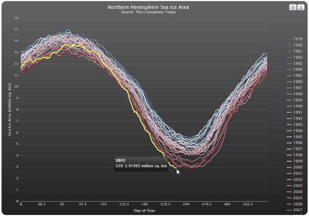
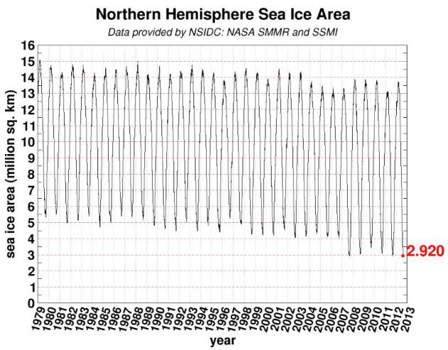
Subject: nearing record low for arctic ice
Paul,
My reading of the chart from Cryosphere indicates
that we are not nearing a record low for arctic ice; we have reached a
record low for arctic ice. Is that correct or am I misreading the chart?
Jeff
Jeffery L. Bineham
Professor of Rhetoric
Department of Communications Studies
St. Cloud State University
New Arctic Sea Ice Minimum. Jeff, you are correct:
at last report: Arctic ice has shrunk down to an area of 2.87743 million
square kilometers, which is a new record low for arctic ice. A recent
storm (unusually strong for August) helped to break up additional ice,
accelerating the downward spiral. Most troubling: another 2-4 weeks of
ice loss is likely. Arctic ice usually reaches a minimum in
mid-September. Data courtesy of
Cryosphere.
What Happens To Advertising In A World Of Streams? It's
amazing to me how many new and "revolutionary" services depend on
advertising to survive. Can they all make it over the finish line?
Doubtful. Here's an excerpt of a thought-provoking article at
gigaom.com focused on advertising in a world of (social media) streams: "
It’s
no secret that more and more of the content we consume is coming in
the form of constantly updated real-time streams, never-ending rivers
that pour through Twitter and Facebook and aggregation apps like
Flipboard. It’s not a new phenomenon, but there’s no question it has
been accelerating, and new offerings like Medium
— the publishing platform from Twitter co-founders Evan Williams and
Biz Stone — as well as others like Pinterest and BuzzFeed and Tumblr
have helped ramp up the rate of adoption, as has the increasing shift to
consuming content on mobile devices. As appealing as these kinds of
services are for users, however, they still have to be paid for
somehow, which raises the question: What happens to advertising in a world made of streams?"
"Winterover": A Novel. "What would you become with
no sun at the coldest place on Earth". That's the question posed by
Ashley Shelby, journalist and author of "Winterover". She's soliciting
funds via
Kickstarter
for her latest project, which is very ambitious, and as a
meteorologist, I am definitely curious to see what Ashley will come up
with. Full disclosure: Ashley is Don Shelby's daughter, in fact both
daughters are working on this project. What will she do with the funds? "
Pretty
simple. I will get the work edited. I'm an editor myself, by trade, so
I know that you cannot--or should not--impose your work on anyone
without first putting it in front of a brilliant and, frankly, ruthless
editor. And yes, this is how much it costs to hire a good editor for a
book of about 400 pages (I bask in the irony of being an editor unable
to afford the prices of her own services!) With any money left over, I
will also build a website for the book. And then I will lean heavily
on my contacts in the New York publishing world, including a handful of
agents who have already expressed interest in the book, to get this
thing into the hands of people who like funny novels with serious
undertones set in weird locations and populated by nailheads, beakers,
artists, cooks, tech geeks, power plant managers, sociologists, and
other denizens of the edge of the world. Can't guarantee a book deal,
but publishing this myself will always be an option on the table."
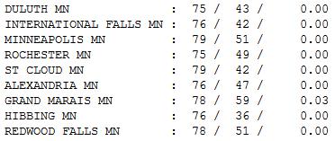
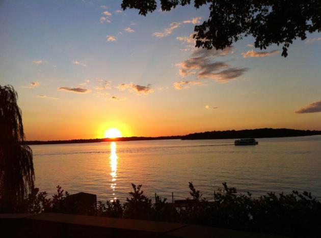
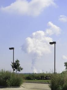
Postcard-Worthy. Our streak of unblemished Mondays
continues. I wish I had a gig that had Monday's off, consistently. I
can't imagine a better day: blue sky, light winds, low humidity, fewer
bugs. Allergy sufferers aren't happy, but everyone else was in a trance
yesterday. Highs ranged from 75 at Duluth and Rochester to 79 at St.
Cloud and the Twin Cities.
Paul's Conservation Minnesota Outlook for the Twin Cities and all of Minnesota
TODAY: Blue sky, another perfect day. Dew point: 44. Winds: S 5-10. High: 81
TUESDAY NIGHT: Clear to partly cloudy, not as cool. Low: 61
WEDNESDAY: Partly sunny, T-shower risk. Dew point: 58. High: 83
THURSDAY: State Fair kicks off! Sticky, slight chance of a T-storm. Dew point: 61. Low: 65. High: 84
FRIDAY: Warm, hazy sun. A few T-storms up north. Dew point: 64. Low: 66. High: 85
SATURDAY: A mix of clouds and warm sun, isolated T-shower late? Low: 68. High: 87
SUNDAY: Hazy sun, a stray T-shower can't be ruled out (but probably no widespread rain). Low: 67. High: 81
MONDAY: What else? Sunshine. Pleasant!. Low: 65. High: 82
The Simple Things
My teenage nieces flew out from D.C. last week
to take in a little Minnesota magic. We did the predictable stuff: Mall
of America, fishing, tubing, biking & hiking. As they got on the
plane I asked what they liked best.
"The campfire and smores" they answered in unison.
"But the BEST thing was seeing shooting stars out on the beach!"
And then it hit me: some of the things I take
for granted, getting a glimpse of the Perseids, or the Northern Lights,
is the source of utter amazement for a kid growing up in the light
pollution of the east coast megalopolis. Sometimes it's the simple
(free) moments that are most memorable.
A stunning Tuesday gives way to more 80s this
week, the first chance of thunder Thursday. I wouldn't let this (small)
risk deter you from heading to the State Fair.
A dying cool front may stall out nearby Sunday; a
period of steadier rain can't be ruled out. Saturday looks like the
better day right now.
Mother Nature has a wicked sense of humor. Long
range models hint at a tropical storm or hurricane impacting Florida
early next week. Folks in Tampa must be holding their breath. The
Republican National Convention kicks off on Monday. What are the odds?
Climate Stories:
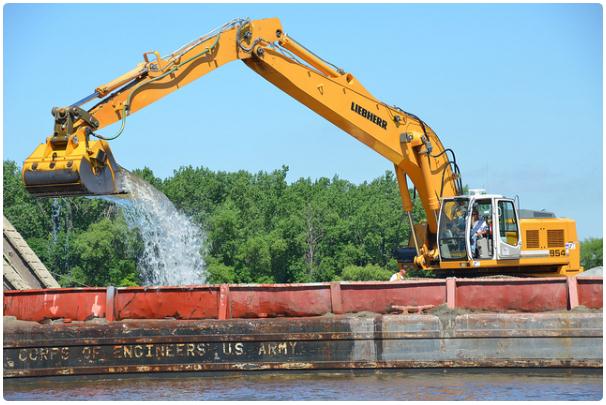
Another Economic Impact Of Climate Change: Drought Is Draining The Mississippi River. Here's an excerpt from
policyshop.net: "...
Currently, near record low river levels requires that the Army Corps of Engineers work non-stop
to keep the Mississippi River passable for cargo ships and transport by
dredging out 60,000 cubic yards of sediment each day. The river
conditions are forcing companies to decrease the number of barges on
the river and the ones that are traveling up and down the river have
decreased their loads. Even with these efforts, 60 vessels have run
aground in the lower Mississippi since May. Plus, while the Corps has
kept the main navigation channel open, harbors along the river have
been closed. Four have closed so far and if the drought continues,
eight more are likely to be closed- leaving 12 out of 19 harbors
closed. These difficulties will increase transportation costs that will
likely be passed on to consumers."
Photo credit above: "
Cottage
Grove, Minn., -- Employees with the U.S. Army Corps of Engineers, St.
Paul District use mechanical dredging to clear the Mississippi River
9-foot navigation channel near Cottage Grove, Minn., June 8. The Corps
uses both mechanical and hydraulic dredging to maintain the channel."
Climate Extremes Reexamined: Can We Quantify The Straw That Breaks The Camel's Back? Here's a snippet from a story at
Think Progress: "....
What this shows first of all is that extreme heat waves, like the ones mentioned, are not just “black swans”
– i.e. extremely rare events that happened by “bad luck”. They might
look like rare unexpected events when you just focus on one location,
but looking at the whole globe, as Hansen et al. did, reveals an
altogether different truth: Such events show a large systematic increase
over recent decades and are by no means rare any more. At any given
time, they now cover about 10% of the planet. What follows is that the
likelihood of 3 sigma+ temperature events (defined using the 1951-1980
baseline mean and sigma) has increased by such a striking amount that
attribution to the general warming trend is practically assured. We
have neither long enough nor good enough observational data to have a
perfect knowledge of the extremes of heat waves given a steady climate,
and so no claim along these lines can ever be for 100% causation, but
the change is large enough to be classically ‘highly significant."
Troubling Trends. Here's another perspective on the loss of arctic sea ice; data courtesy of
NSIDC: NASA SMMR and SSMI.
FutureDude And Climatologist John Abraham, Part 2.
Here's an excerpt of the second part of an interview between futurist
Jeff Morris and St. Thomas climate scientist John Abraham at
futuredude.com: "
Tell me about four and five degree changes. What would we see?
"
Before climate change, the drought we had this year would have
been a one in 300-year occurrence. And it’s now a one in 10 to 20-year
occurrence. So, it’s making these things much more common. And as we go
further, this drought will become the standard.
How will society react to that? It will be tough.
There are two studies that just came out in the last month that
have shown very conclusively that the number of extreme weather events
has increased and gotten more severe. One came out of NASA and the
other came out of NCAR — the National Center for Atmospheric Research.
They didn’t even include this year’s data. It’s not just that this is
what climate change is like. This will be a good year in the future."
So, if the climate changes slowly, we could be lucky and still fix things. What if it shifts rapidly?
"
If we pass a ‘tipping point’ — like the full release of methane
in Siberia — we may not be able to regain control. We can still do
something about it right now."
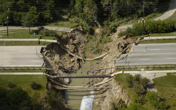
Climate Change: How Toronto Is Adapting To Our Scary New Reality.
The farther north you go, the more dramatic the warming has been over
the last 30-40 years. Here's an excerpt of a story from Toronto's
thestar.com: “...
We
wanted to get a better understanding of the weather patterns, in
particular the extreme weather events that we are likely going to be
experiencing as a result of climate change for the Toronto area through
the period 2050,” says TEO director Lawson Oates. “If we generally look
at, you know, there'll be an average one degree increase Celsius,
people have the sense well, that's manageable. But if you look at an
extreme event, that's where the real concern is, both the
infrastructure side and also the impacts on vulnerable populations.”
When Robert Sandford considers a one degree temperature increase, he
ponders the Clausius-Clapeyron relation — formulated in the mid-19th
century by a German physicist and a French railway engineer. “What they
calculated was that the amount of water the atmosphere can hold
increases by about seven per cent per degree Celsius,” he says. “You can
see what that means. You could actually model how much atmospheric
moisture there will be in a warmer atmosphere.”
Photo credit above: "
A washed out section Finch Ave. W., west of Keele St., is seen from a helicopter in August, 2005." Lucas Oleniuk/Toronto Star.
Once analyzed, the data
show a clear trend. According to Greg Breed, lead author on the study
and a post-doctoral fellow at the Harvard Forest in Petersham, Mass.,
"Over the past 19 years, a warming climate has been reshaping
Massachusetts butterfly communities." Subtropical and warm-climate
species such as the giant swallowtail and zabulon skipper—many of which
were rare or absent in Massachusetts as recently as the late 1980s—show
the sharpest increases in abundance
Read more at:
http://phys.org/news/2012-08-massachusetts-butterflies-north-climate-video.html#jCp. Here's an excerpt from
cleantechnica.com: "
At
a twin-unit nuclear power plant in northeastern Illinois, the weather
recently became so hot that the temperature of the cooling pond of the
plant exceeded the level permitted, at 102 degrees. The permitted level
was originally 98 degrees, and has been increased to 100 degrees."
Climate Sanity And The Necessity Of Fully-Burdened Cost And Benefit Analysis.
This is a bit technical, but it's a worthy read, especially the next
time you hear a skeptic, cynic (or full-blown climate denier) talk about
"it's too expensive for us to do anything about". Here's an excerpt
from a recent post at
getenergysmartnow.com: "...
To
date, those industries profiting from fossil fuel dependency have been
effective articulating and reinforcing the message that addressing
climate change will create widespread economic costs. Study-after-study
appears ‘proving’ that climate policy will result in massive
unemployment and damage the economy for decades to come. Coupled with a
message of uncertainty over the soundness of the science of climate
change, this strategy has effectively undermined attempts to pass
federal limits on greenhouse gas emissions. At the same time, advocates
for climate policy have unwittingly reinforced this message that
climate policy must be costly. In the most recent campaign to pass
climate legislation in Congress, following a Congressional Budget
Office (CBO) analysis of the Waxman-Markey “American Clean Energy and
Security (ACES) Act,” climate
advocates gleefully announced that contended that ACES would achieve
its objects ‘for the cost of a postage stamp a day’ per family.
While clearly aimed at diffusing the notion that climate policy would
be prohibitively costly, the message explicitly yielded the argument:
climate action will “cost” Americans and the only argument is over how
much."


The sandbars that are revealed look like beaches, inviting boaters, fishermen and hikers to venture out. Experts agree that can be a very bad idea. Sewer Repair Baltimore MD
ReplyDelete