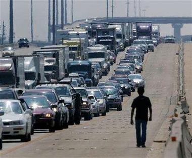
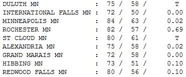
84 F. high on Wednesday in the Twin Cities (considerably warmer than predicted).
76 F. average high for September 5.
72 F. high on September 5, 2011.
.02" rain fell on the metro early Wednesday.
.69" rain soaked Rochester yesterday (strong to severe storms rumbled across far southern Minnesota).
.21" rain predicted for MSP late tonight ahead of a
second, stronger cool front. Highs hold in the 60s behind the front
Friday; the coolest day in sight.
 September Breeze
. ECMWF
(European)
model data suggests a cool Friday, highs stuck in the 60s with a brisk
north wind. We warm up to near 70 Saturday, low to mid 70s Sunday with
less wind, highs reaching into the 80s Tuesday before cooling off again
by the middle of next week. No significant rain is in sight. As lovely
as this weather is, 2-4" rain over 2-3 days would qualify as lovely
right now.
 39.14"
 of rain fell on Pensacola, Florida during
meteorological summer (June 1 to August 31). That makes this the wettest
summer on record, 14.94" wetter than average. The previous record:
37.04", in 1994. Source: HootSuite.
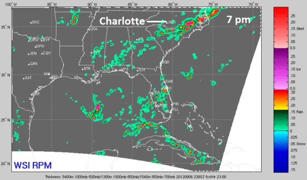
DNC: Did They Jump The Gun By Moving The President Indoors?
Full disclosure: I wouldn't want to be the poor schmuck providing
hourly weather updates and forecasts for the Democratic National
Convention in Charlotte. Based on a forecast of strong/severe storms
President Obama's address was moved indoors, to a much smaller venue
this evening. But if the ultra-high-resolution WSI RPM model is correct,
most of the storms will be east of Charlotte by 7 pm edt. Yes, it's
close for comfort, but it would be ironic, after scrambling and moving
to Plan A, if the skies over Charlotte were tranquil this evening. We'll
see.
“Oh, my bones are aching. It must be about to rain.” – Everybody’s grandpa, ever.
An interesting post, on why old injuries, aches and pains often flare
up ahead of a storm or frontal passage from mentalfloss.com, below.
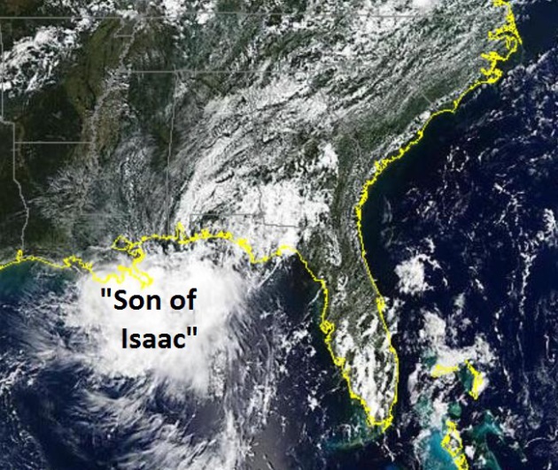
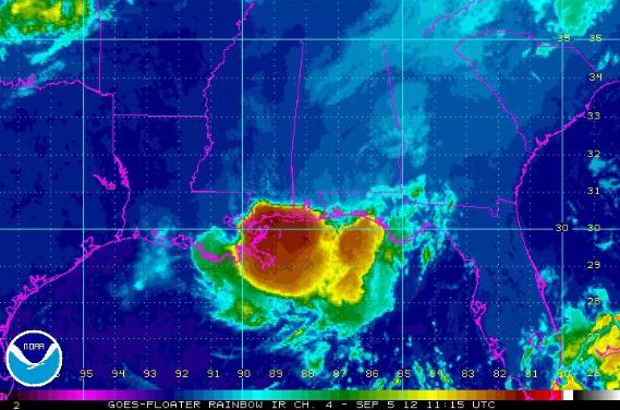
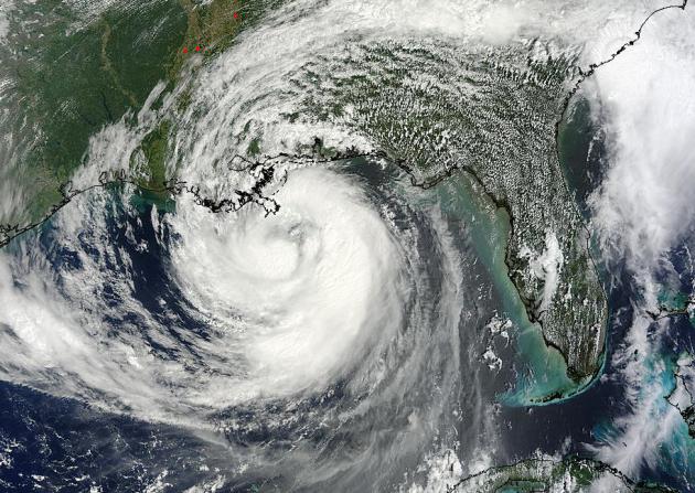
It's Baaack. Isaac's soggy dregs pushed up the
Mississippi, then veered across the Ohio Valley toward Pennsylvania. But
a tiny chunk of energy, moisture and "spin" did a giant loop, pushing
south across Kentucky and Tennessee into Alabama (squeezing out some
10-15" rains), now winding up where it started early last week - off the
Louisiana coast, where it may strengthen back into a tropical storm.
Something similar happened in the 90s, but I can't remember a hurricane
weakening, then coming back from the dead like this for 15-20 years.
According to
NHC there's a 50% chance it could become a tropical storm....probably not Isaac. Next up: Nadine? Image:
NASA MODIS.
Hurricane Naming Conventions: When Is It OK To Recycle A Name? Here's some additional guidance and perspective from
The National Hurricane Center (NHC), via FB: "
There
have been quite a few inquiries about whether the name "Isaac" would
be given to the area of disturbed weather currently located along the
northern coast of the Gulf of Mexico, if it were to develop into a
tropical cyclone. The short answer is no, it would get a new name. Our
analysis of the satellite, surface, and lower-tropospheric radiosonde
data suggested that the disturbance we're currently following
originated within Isaac's broad circulation, but that it had its own
surface pressure minimum distinct from Isaac's. This was perhaps most
apparent late in the day on Monday, when the residual surface center of
Isaac was located over western Kentucky while a second weak low was
located over northern Mississippi and Alabama. Isaac's circulation
continued to weaken after that and became difficult to track, while the
new disturbance moved slowly toward the Gulf coast. So what basically
happened here is that a little piece of Isaac broke away and moved
south. OK, now everybody get your lawyer and grammar hats on. The
National Weather Service rule that applies here reads: "if the remnant
of a tropical cyclone redevelops into a tropical cyclone, it is
assigned its original number or name". Notice the rule says "the"
remnant, and not "a" remnant. This means that the storm's
primary remnant (and not just any old part of it) has to re-develop in
order for the name to be retained. Since the primary remnant of Isaac
was still in Kentucky when the new low formed and broke away, the rule
dictates that the new low is not entitled to the name Isaac.
This rule actually makes a lot of sense. If a storm died and each of
two parts re-developed, we couldn't give the same name to both parts.
Only the primary remnant would retain the name, while a lesser remnant
or part would get a new name."
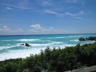
"Bermuda Shorts". David Lahuta is a Bermuda-based travel writer and TV correspondent, and he updates
his blog
on a regular basis. He's bracing for the arrival of Hurricane Leslie.
We'll be checking back to see how he (and the island) weather what could
evolve into a category 2 hurricane. Here's an excerpt of his latest
post: "
On its current track the storm is expected to approach
Bermuda this weekend, with winds as much as 110 mph forecast to whip the
western portion of the island (a.k.a. The End Where I Live). However,
my catastrophe modeler insurance pals are calling for a direct hit from a
Category 2 hurricane sometime on Sunday. And trust me, these people
know what they're talking about. Their business is risk. If the surf
that's been rolling over the island's south shore is any indication,
Bermuda should start bracing for something major (the above picture
taken yesterday from Warwick Long Bay doesn't even do it justice; the
surf is indeed up)."
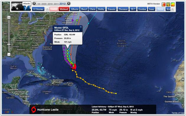
GFS Solution: 5 pm Saturday. You can understand why
David and every other resident of Bermuda is concerned. Models are
hinting at a Category 2-3 hurricane coming very close to Bermuda over
the weekend. With a little luck the center of Hurricane Leslie will pass
just east of this island nation.
 Another Cool Front...and "Leslie"
.
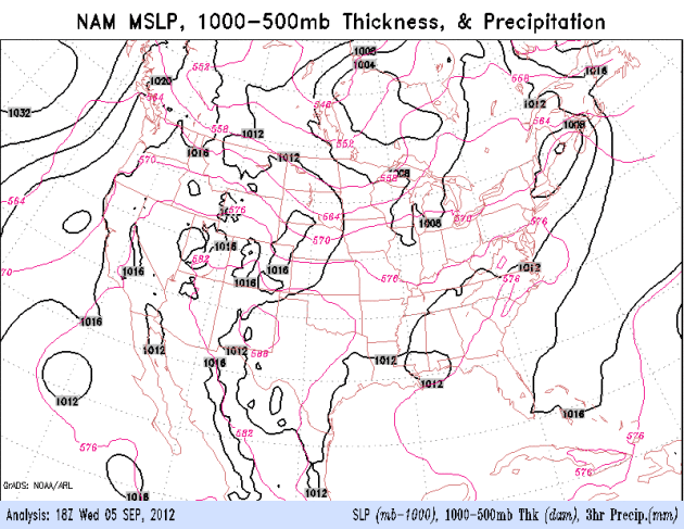
The NAM model shows another band of showers pushing across Minnesota
tonight, followed by a Friday clearing trend. Note Hurricane Leslie
coming into view on screen right, risk to Bermuda, but probably not the
east coast of the USA. Is it me or does Leslie appear to be tracking
more northwest than north? I hope it's an optical illusion.
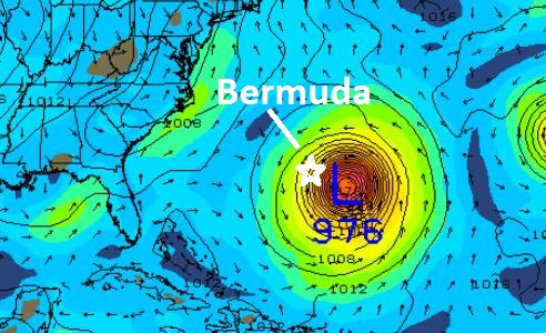
Predicted Track of Hurricane Leslie. New England
will be spared (although surfers will be very happy on Cape Cod by the
weekend). Bermuda may take a direct hit from a Category 2 hurricane
(GFDL model above shows sustained winds of 101 mph by Sunday); and with
North Atlantic water temperatures as much as 10 F. warmer than average, I
wouldn't be surprised to see Leslie maintain hurricane status as it
comes ashore over Newfoundland, Canada early next week. Map: Ham
Weather.
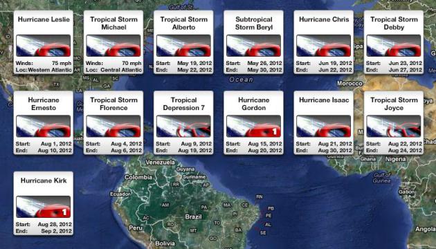
7 Hurricanes. Just because a hurricane doesn't hit
the USA (or some other country) doesn't mean that it doesn't "count".
Michael was upgraded to a hurricane overnight, the 7th Atlantic
hurricane of 2012 so far. Graphic: Ham Weather.
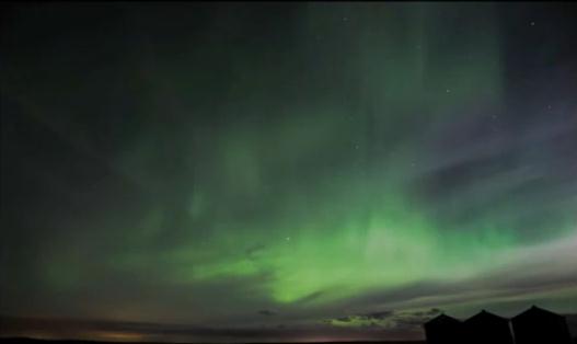
Aurora Watch. I seem to have better luck seeing the
Northern Lights in Autumn than any other season. Skies are clear, fewer
storms and fronts, and with lower dew point and drier air and less
haze/humidity it makes it easier to see one of the most impressive
spectacles you'll ever witness. With numerous solar flares in recent
days the odds of seeing The Northern Lights, the Aurora Borealis, just
went up. There's no way to predict this magical phenomenon in advance,
but it might be worth a look in the coming nights. Here's a great
YouTube video clip from Calgary, courtesy of
Canadart.net:
"
Clouds, Shooting stars and northern lights. We went for a tiny drive
north of Calgary (Alberta, Canada) after being informed there was a show
coming our way. It really worth the drive."
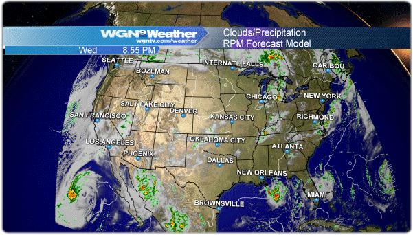
RPM Model. This is one of the better weather models
out there, created and maintained by WSI, Weather Services
International, owned by The Weather Channel. Tom Skilling has the best
weather team in Chicago at WGN-TV. You can check out the latest
(national) model run at
chicagoweathercenter.com. Good stuff.
7 TRILLION Gallons Of Water From Hurricane Isaac? Bob Ryan is a TV meteorologist at WJLA-TV in Washington D.C., one of the legends in the industry, a real pro. He had a
blog post that caught my eye in the wake of Isaac, some truly eye-opening numbers that make my brain hurt. Here's an excerpt: "
You would have to stand there every minute, every day for about 3 MONTHS to see 7 trillion gallons. Or
7 trillion gallons is also enough fresh water to give every man, woman
and child on earth, 1 gallon of fresh water every day for about 3
years. Monster storm such as Isaac are tremendous engines
that create enormous power and destruction and indeed incredible
amounts of water. And Isaac is not doe yet. The winds are decreasing
but the path is very likely to bring some rain our way before the Labor
Day holiday weekend is over...."
Hurricane Isaac Sweeps Tons Of Dead Rats Onto Mississippi Beaches. The appetizing details from
The Star Online and Reuters: "
Tens
of thousands of rats killed by Hurricane Isaac have washed up onto the
beaches of Mississippi and created a foul-smelling mess that officials
say will take days to clean up. When the hurricane lifted the tides,
the water washed across the marshy areas in Louisiana where the
semi-aquatic rats live and forced them to ride the waves into
Mississippi until they succumbed to exhaustion and drowned, said David
Yarborough, a supervisor for Hancock County on the Gulf Coast."
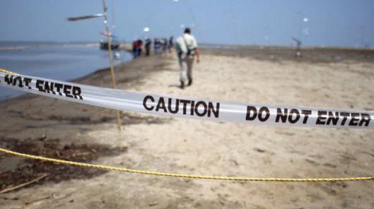
Hurricane Isaac Deposits Oil, Possibly From Deepwater Horizon, On Louisiana Beaches. The story from
Mother Nature Network; here's a clip: "
The
beaches of Elmer's Island in Louisiana are "littered with tar balls of
every size," according to Robert Barham, secretary of the Louisiana
Department of Wildlife and Fisheries. The oil and tar balls, probably
originating from the BP Deepwater Horizon oil spill of 2010, were
stirred up by Hurricane
Isaac last week and extend as far as a mile out to sea, forcing the
state to close 12 miles of Gulf coastline to fishing and other
activities, the New Orleans Times-Picayune
reported. Barham told the press that the tar balls will be analyzed to
see if they originated from the Deepwater Horizon spill. A spokesperson
for the U.S. Department of the Interior told Our Amazing Planet
last week that an estimated 1 million gallons of oil from the
Deepwater Horizon spill are hiding in the underwater sediment off the
coast of Louisiana, as well as in marshes and on nearby beaches. The
hurricane was expected to stir up sediment and release oil, pesticides,
fertilizers and other toxic chemicals..."
Photo credit above: "
A Louisiana Wildlife and Fisheries officer walks along an oiled beach at South Pass in southern Louisiana in 2011." (Photo: John Moore/AFP Global Edition)
NOAA's "Weather Central" Settles Into Its New Home.
800+ scientists and employees of the National Weather Service in
Washington D.C. are moving to new digs. Here's an excerpt of a post at "
The Front Page", from the American Meteorological Society: "
Riverdale,
Maryland’s 800 newest citizens are starting to move in: the suburb of
Washington, D.C., which is just a hailstone’s throw from the University
of Maryland, is suddenly inheriting a major influx of meteorologists
and their colleagues. This newcomers are a cadre of NOAA scientists with
a long history behind them, and with the opening of the new 268,762
square-foot, four-story National Center for Weather and Climate
Prediction, a new era begins for the National Centers for Environmental
Prediction as well as colleagues from the National Environmental
Satellite, Data, and Information Service and the Air Resources
Laboratory."
Photo credit: "
David Caldwell and Louis Uccellini, back in
April, awaiting a first meeting at the then-unfinished new home for
NCEP and other NOAA groups, in Riverdale, Maryland."
Coast Moms: Tips To Prepare Your Kids For A Hurricane. Some good advice here for parents, and much of this applies to tornadoes as well as hurricanes. Here's an excerpt from
pnj.com: "...
Even
though Isaac is behind us, storm season doesn’t end for another two
months. There’s always the possibility of another hurricane or tropical
storm that you will need to explain to your children.
Mental health professionals say it’s important to keep children’s
anxiety levels low during an event like a hurricane. Christine Chaffin,
a licensed mental health counselor at Lakeview Center, said how you
talk to your children about hurricanes depends on how old they are.“The
biggest thing is to not overwhelm,” said Chaffin, who has two
daughters, ages 5 and 9. “Some kids are going to ask a lot of
questions. You want to answer truthfully, but age-appropriately. Always
go back to the concept of, ‘I am the parent, I will keep you safe.’
Why Does Bad Weather Aggravate Old Injuries? Here's a fascinating post from
mentalfloss.com.
Now I have a good answer to a question that comes up all the time. "Why
does an approaching storm or front make me ache?" Here's an excerpt: "
The
idea that certain aches and pains correspond with, and can even
predict, the weather is widespread, and has been around since at least
the days of ancient Greece. The typical explanation for
bad-weather-related aches is that the drop in barometric pressure that
comes with a storm causes soft tissue and fluid around joints to expand,
irritating nerves and causing pain, especially at the sensitized site
of an arthritic joint or an old injury. The scientific evidence for the
phenomena, which has been studied since the early 20th century, is
mixed. Some studies have found that changes in barometric pressure
increased pain, others found that it decreased it, and still others
found no correlation. The influence of temperature and relative
humidity has also been studied, and is also unclear. (For more on some
of this research, see here and here)."
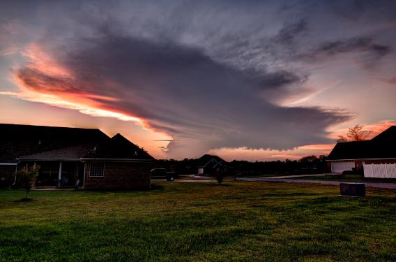
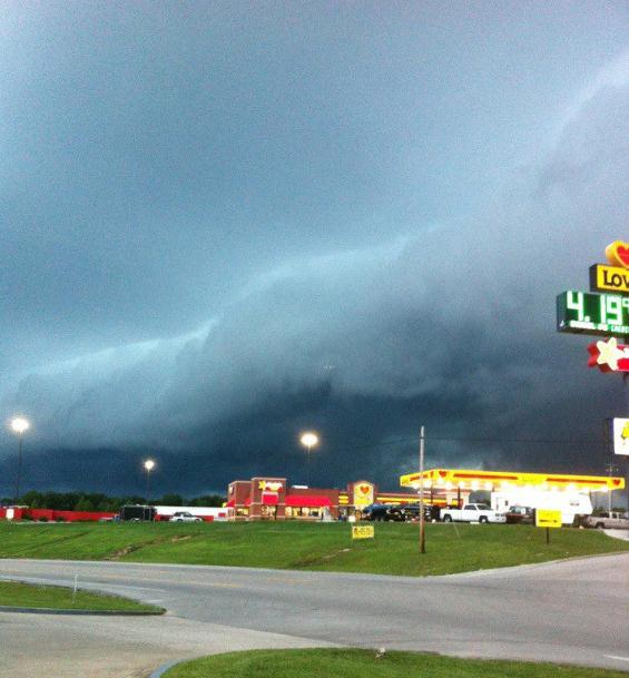
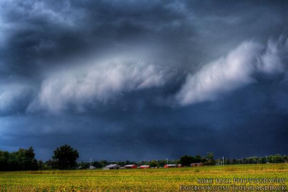
Photos That Caught My Eye Yesterday:
Super-Anvil. Allen Gresham captured this sprawling
thunderhead anvil near Starkville, Mississippi Wednesday. Talk about
upper level divergence! Geek-speak for ripe conditions aloft for
hurricane formation.
Shelf Cloud. Jeanne Martin snapped this photo out
ahead of yesterday's squall line that swept across the Ohio Valley.
Photo from North Corbin, KY via
Facebook and WeatherNation TV.
A Ragged Sky. Thanks to Mike Hall for sending this
terrific photo along yesterday. Details: "
Gust front moving in at the Hancock Co. KY Airport at 1:46pm today. www.kickstarter.com/projects/965464473/to-hail-and-back
If Content Is King, Multiscreen Is The Queen, Says New Google Study.
So how many screens do you use during a typical day? Migrating from
desktop to tablet or smartphone for much of your work and entertainment?
Here's an excerpt of an article at
Tech Crunch: "
New research
out from Google, working with market analysts Ipsos and Sterling
Brands, puts some hard numbers behind the often-noticed trend of how
people in the U.S. are using a combination of phones, tablets, computer
and TVs to consume digital content. While each of these has a
significant place in our consumption today, their real power lies in
how they are used together — in combination, 90% of all of our media
consumption, or 4.4 hours per day, is happening across all four (which
doesn’t leave much room for paper-based books and publications; or for
radio). This not only has implications for how content is designed, but
also for how companies like Google will continue to hedge their bets
across all four screens."
It's Becoming Clear That No One Actually Read Facebook's Prospectus Or Mark Zuckerberg's Letter To Shareholders. Here's a clip from an interesting article at
Business Insider: "
As Facebook's stock continues to collapse, the volume of whining is increasing. Four months ago, you will recall, Facebook was viewed as "the next Google."
Now, with no major change in the fundamentals, it's viewed as an
over-hyped disaster. Meanwhile, there is ever-louder grumbling that
26-year-old Facebook CEO Mark Zuckerberg is in over his head and should
be relieved of command. As I listen to all this whining, I have a
simple question: Didn't anyone even read Facebook's IPO prospectus? The
answer, I can only assume, is "no."
Face-Scanning Cameras Could Pick Out Drunks. As if
you're not already paranoid enough about all those cameras out there
tracking you, here's one more reason to be concerned. Maybe I won't have
that second drink. Details from
gizmag.com: "
People
who are inebriated in public places (such as airliners or malls) can
definitely create problems. Sometimes, though, it’s difficult to tell
if someone really is under the influence. Instead of making every
“jolly”-looking person take a breathalyzer test, Greek researchers are
suggesting something less intrusive – video software that can spot
drunks by analyzing their faces. The software, which is currently being
developed at the University of Patras, works in two ways."
Strengthen Your Self Control. How To Improve Your Willpower And Overcome Urges. I somehow worked up the will to read this article from
livestrong.com; here's an excerpt: "...
But
there’s another trick you can use if you feel your willpower slipping:
Flex your muscles. Iris W. Hung of the National University of
Singapore and Aparna A. Labroo of the University of Chicago conducted a
study in which participants were who were instructed to tighten their
muscles, regardless of which muscles they tightened, demonstrated a
greater ability to withstand pain, consume unpleasant medicine, attend
to disturbing but essential information and overcome tempting foods. The
researches theorize that the body primes the mind. Mental imagery,
used by athletes worldwide, is another willpower hack. According to
Harvard researchers, people who do a good deed or who imagine doing a
good deed are better able to perform tasks of physical endurance. In a
strange twist, those who envisioned themselves doing something bad had
more endurance than those who envisioned themselves doing something
good. In this case, researchers believe that the mind primes the body."
Photo credit: iStockphoto.
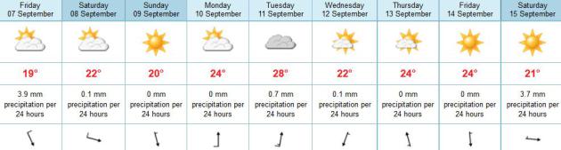
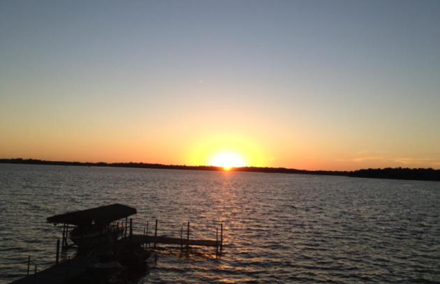
 Weekend Weather Preview.
Yes, we will all learn the metric system, kicking and screaming into
the 21st century. The web site I use (ECMWF model data) only displays in
metric. English units aren't even an option, so there you go. Good
news: a fine weekend is shaping up with low humidity; Sunday the warmer
day for the lake with less wind.
A More Comfortable Front. You could feel it in the
air, a big drop in humidity. Dew points were in the 60s Tuesday, but a
brisk west wind behind cool front #1 dropped dew points into the 40s by
late afternoon yesterday. There was enough residual warm air in the
lowest few thousand feet of the atmosphere for temperatures 5-10 F.
warmer than average, ranging from 72 at Grand Marais to 80 St. Cloud, 84
in the Twin Cities.
Paul's Conservation Minnesota Outlook for the Twin Cities and all of Minnesota:
TODAY: Plenty of warm sun, pleasant most of the day. Dew point: 44 Winds: W 10. High: near 80
THURSDAY NIGHT: Unsettled with showers, possible thunder late. Low: 55
FRIDAY: Feels like September. Slow clearing, cooler. Winds: N 10-15. High: 67
SATURDAY: Clouds & sun. Wisconin showers? Winds: NW 10+. Low: 50. High: 68
SUNDAY: Bright sun, less wind. Perfect. Low: 53. High: 74
MONDAY: Sunny and milder. Dew point: 48. Low: 55. High: 78
TUESDAY: Summer fling. Warm sun, then clouds increase. Dew point: 53. Low: 63. High: 82
WEDNESDAY: Sunny, breezy and cooler. Low: 53. High: near 70
A September Bias
For the record (not that anyone cares all that
much) I like snow, I enjoy autumn, I tolerate February, but I LOVE
September. In fact I suspect that, as warm weather months go, this may
well be the best month of the year.
Your Honor, let me make my case! June is peak
severe month; buckets or rain and sirens every other day. July is the
hottest month of the year. No kidding. August in fine, but humidity
levels are high and bugs still show up on Doppler.
By September dew points drop, highs are in the
60s & 70s, lake water still warm enough for one more dip; mellowing
leaves: odds of a dry weekend higher than summer.
September is prime time for hurricanes and fog.
Mercifully we only have to deal with the latter, the result of lingering
moisture and longer nights allowing the air to cool to the dew point,
creating lazy clouds: fog.
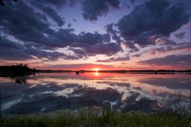
A cool, sunny start gives way to increasing
clouds; showers possible tonight ahead of a reinforcing surge of
Canadian air. Get ready for a string of days in the 60s and low 70s into
Sunday; the nicer, sunnier day of the weekend. A Saturday clipper may
spark showers over Wisconsin; probably dry for Minnesota.
Clippers are back?
Sign of the times.
* photo above courtesy of Steve Burns.
Climate Stories...
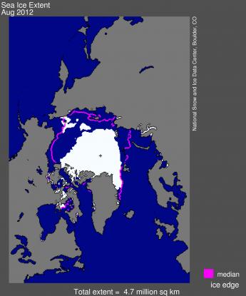
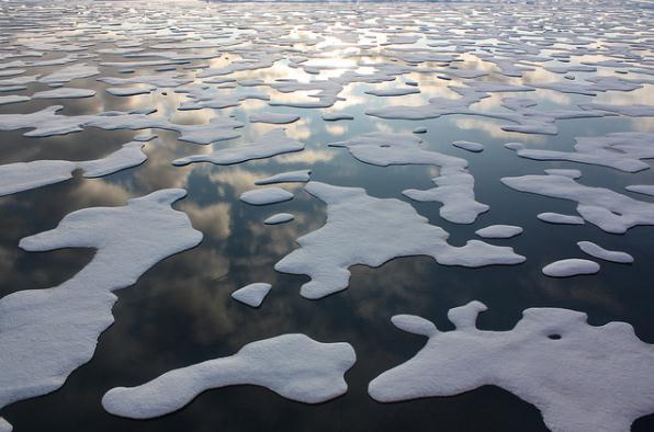
Arctic Sea Ice Falls Below 4 Million Square Kilometers. Here's an excerpt from
The National Snow and Ice Data Center: "
Following the new record low recorded on August 26,
Arctic sea ice extent continued to drop and is now below 4.00 million
square kilometers (1.54 million square miles). Compared to September
conditions in the 1980s and 1990s, this represents a 45% reduction in
the area of the Arctic covered by sea ice. At least one more week likely
remains in the melt season."
Graphic credit above: "
Arctic sea ice extent for August
2012 was 4.72 million square kilometers (1.82 million square miles).
The magenta line shows the 1979 to 2000 median extent for that month.
The black cross indicates the geographic North Pole."
Sea Ice Index data.
About the data. Credit: National Snow and Ice Data Center.
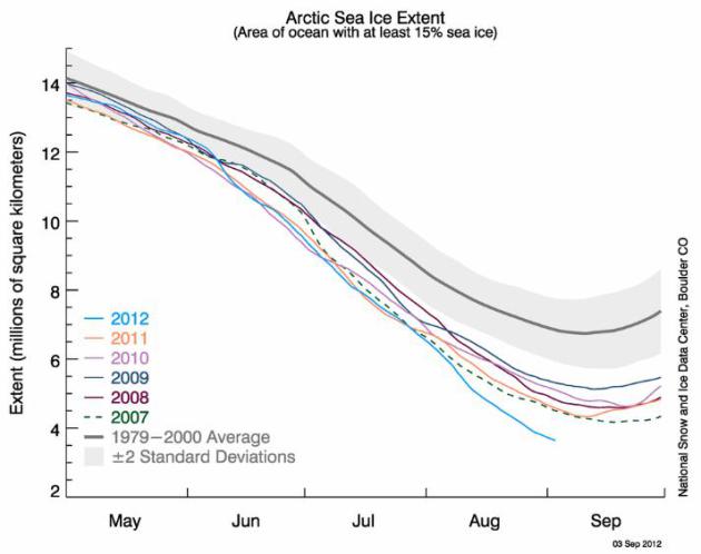
Uncharted Waters. More detail from NSIDC: "
The
graph above shows Arctic sea ice extent as of September 3, 2012, along
with daily ice extent data for the previous five years. 2012 is shown
in blue, 2011 in orange, 2010 in pink, 2009 in navy, 2008 in purple,
and 2007 in green. The 1979 to 2000 average is in dark gray. The gray
area around this average line shows the two standard deviation range of
the data."
Sea Ice Index data. Credit: National Snow and Ice Data Center.
Perspective: "
Compared to September conditions in the
1980s and 1990s, this represents a 45% reduction in the area of the
Arctic covered by sea ice. At least one more week likely remains in the
melt season." - Leo Hickman
On Thin Ice: Time-Frame To Save The Arctic Is Melting Away. More disturbing news in this post at
climatecodered.org; here's an excerpt: "
Something
extraordinary is happening when graphs of melting Arctic sea-ice have
their vertical axis redrawn because the data are falling off the chart.
But that’s what has occurred in the last 10 days, since the extent of
floating Arctic sea-ice broke the satellite-era minimum record
on 24 August. On that date it was 4.2 million square kilometres,
according to data from the Japan Aerospace Exploration Agency. Since
then, an additional half a million square kilometres of sea-ice has
melted. The extent on 4 September was just half of the average minimum extent of the 1980s.
At the current rate of loss, with one to three weeks left in the
northern melt season, the minimum may well shrink below 3.5 million
square kilometres. This is an astounding story...."
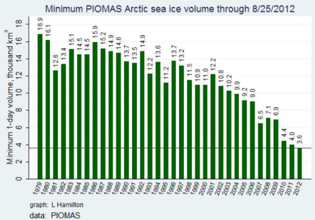
Death Spiral Watch: Experts Warn "Near Ice-Free Arctic In Summer" in A Decade If Volume Trends Continue. Details from
Think Progress: "
The
sharp drop in Arctic sea ice area has been matched by a harder-to-see —
but equally sharp — drop in sea ice thickness. The combined result has
been a collapse in total sea ice volume. Many experts now say that if
recent volume trends continue we will see virtually ice-free conditions
sometime in the next ten years. And that may well usher in a permanent
change toward extreme, prolonged weather events “Such As Drought, Flooding, Cold Spells And Heat Waves.” It will also accelerate global warming in the region, which in turn will likely accelerate both the disintegration of the Greenland ice sheet and the release of the vast amounts of carbon currently locked in the permafrost."
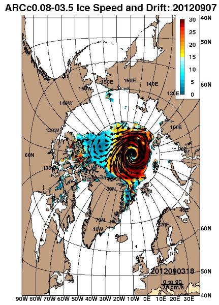
Another Major Arctic Cyclone Set To Accelerate Ice Loss. Here's a portion of a post from Dr. Paul Beckwith at
Arctic News: "...
Most
scientists think that the massacre of Arctic sea ice will stop on/or
around September 15th which is the 'normal' date at which ice formation
is due, as the decrease of solar insolation at the pole will cause the
area of the sea ice to start increasing", Paul says, adding however
that “a minority of us think that the melt will continue beyond this
date by several weeks, due to the warmness of the sea water both beside
and below the very thin sea ice.” Paul continues: “In fact, I predicted
on August 10th that at the end of the melt season there would be
virtually no sea ice left; this was predicated on there being a few
more cyclones of equal intensity to that of the August 2nd to August
10th cyclone that eliminated around 0.8 million square kilometers of
sea ice area (equivalent to about 20% of the ice remaining in 2007, the
previous worst year in terms of ice melt). Thankfully, my prediction
looks to be wrong, but we are not out of the woods yet. It appears that
a strong cyclone will be attacking the sea ice in a few days, with the
peak churning occurring on September 7th.”
Ruined Summer: How Climate Change Scorched The Nation In 2012. Here's a brief overview of a report from
The National Wildlife Federation, with a link to the full report: "
It
is certainly altering them in dramatic ways and rarely for the better.
The summer of 2012 has been full of extreme weather events connected to
climate change. Heat records have been broken across the country,
drought conditions forced the United States Department of Agriculture
(USDA) to make the largest disaster declaration in U.S. history, and
wildfires have raged throughout the West. New research by world-renowned
climate scientist James Hansen confirmed that the increasingly common
extreme weather events across the country, like record heat waves and
drought, are linked to climate change. This report examines those
climate change impacts whose harm is acutely felt in the summer. Heat
waves; warming rivers, lakes, and streams; floods; drought; wildfires;
and insect and pest infestations are problems we are dealing with this
summer and what we are likely to face in future summers."
Mitt Romney: Climate Change Is Real, But Addressing It Would Be Wrong. The story from
Boing Boing; here's an excerpt: "...
Perhaps
most surprising was his response to a question about climate change.
Instead of attempting to flatly deny the evidence, Mitt Romney has
apparently moved on to acknowledging that climate change is
happening—while simultaneously overplaying the uncertainty surrounding
specific risks, and claiming that even if climate change is a big
problem there's nothing we can really do about it anyway ... because
China. Personally, I think that's pretty interesting. Climate
scientists, and the journalists who write about them, have been
talking, anecdotally, about seeing this exact rhetorical shift
happening in conservative circles. It seems that the Republican
presidential nominee is now one of the people who acknowledge climate
change exists, but would still rather not take any decisive steps to
deal with it."
Another media spin to the same climate science questionaire:
Is Romney Warming Up To Global Warming? Here's an excerpt of an Op-Ed at
The Washington Post: "...So Romney’s response to a questionnaire — prepared by
Scientific American and
ScienceDebate.org
— is one interesting sign of the emergence of the post-primary
candidate. Romney endorses the view “that the world is getting warmer,
that human activity contributes to that warming, and that policymakers
should therefore consider the risk of negative consequences.” He
accepts, in short, the consensus view of the National Academy of
Sciences, while raising some questions about the pace of climate change
and the extent of human contribution. Romney goes on to say that
cap-and-trade legislation is not the answer, since it only applies to
the United States and not to the developing world, where the growth in
carbon emissions is greatest. The alternative, in his view, is a “no
regrets” policy, in which this nation lowers emissions through new
technology instead of regulations that impose a competitive
disadvantage on the economy."
"Sign Our Petition To Ask Obama And Romney At the Presidential Debate: "How Do You Plan To Address The Climate Crisis?" Consider signing the
online petition from The League of Conservation Voters:
Our Petition
"
Put Climate Change on the Agenda in the First Presidential Debate
Dear Mr. Lehrer,
In your role as moderator of the first presidential debate, you
have the opportunity to ask questions about the most pressing issues
facing our country. We urge you to ask President Obama and Governor
Romney how they will confront the greatest challenge of our generation
-- climate change.
This summer, the climate crisis has fallen right into America's front
yards--in some cases literally. With trees crashing through their
windows, fires burning through their neighborhoods, water flooding under
their doorsteps, and droughts destroying their crops, Americans have
been hurting from the effects of weather extremes that climate
scientists have predicted would happen as a result of global warming."
Obama and Romney On Climate Change Science. Here's a good recap on each candidate's position on climate science from meteorologist Jason Samenow at The Washington Post's
Capital Weather Gang. An excerpt from an important article: "
With
the race to the White House heating up, it raises the question: where
do the presidential candidates stand on global warming? In short,
Obama is a global warming “believer” but has provided little substance
to back his conviction and seldom talks about it. Romney, on the other
hand, presents a wavering, sometimes mocking assessment on the severity
of the issue."
Obama
"
In nearly four years in office, Obama has occasionally paid lip
service to the “threat of climate change”, but has yet to use his bully
pulpit to lay out the scientific case in a high-profile setting. He
once in a while mentions climate change in passing, but has yet to
discuss its causes, the evidence, and potential impacts in detail. As a
perfect example, at a speech in Charlottesville, Va. last week, Obama’s token reference to climate change was: “Denying climate change doesn’t make it stop...”
Romney
"
Romney’s position on climate change science has shifted around as Brad Plumer documents on the Wonk Blog:
As recently as June 2011, Romney was telling voters in New
Hampshire that “the world’s getting warmer,” that “I believe that
humans contribute,” and that “I think it’s important for us to reduce
our emissions of pollutants and greenhouse gases.”Since then,
however, Romney has softened his stance. “I don’t know if [rising
temperatures are] mostly caused by humans,” he told another New
Hampshire crowd last summer.


No comments:
Post a Comment