77 F. high in the Twin Cities Sunday.
65 F. average high for September 30.
64 F. high on September 30, 2011.
+1.7 F. The first 29 days of September are running 1.7 F. warmer than average in the Twin Cities.
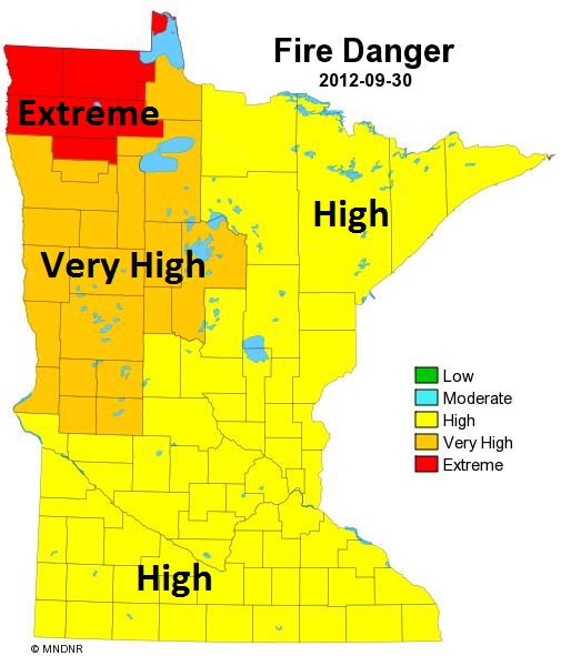
High fire danger statewide; an extreme fire risk over the Red River Valley.
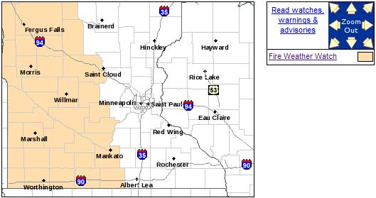
Fire Weather Watch posted for roughly the western half of Minnesota today.
Wet snow possible over northern Minnesota by Thursday, possibly a light accumulation of slush over the Arrowhead.
Frost/freeze possible for Twin Cities suburbs next weekend.
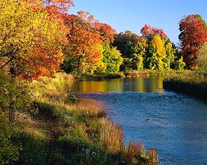
Goodbye Summer...? Was this the last weekend of 80+
high temperatures across the state? Probably, although I'm fairly
positive we'll see more 60s and a few 70s again by mid-October.
Fire Weather Watch. Drought, coupled with sunshine,
low humidity and gusty winds will mean an elevated risk of brushfires
again today for much of western and central Minnesota; details from the
NWS:
...FIRE WEATHER WATCH IN EFFECT MONDAY AFTERNOON AND EVENING FOR
WESTERN AND SOUTHWESTERN MINNESOTA...

.A DRY COLD FRONT WILL SWEEP THROUGH THE REGION FROM WEST TO EAST
LATE TONIGHT THROUGH MONDAY. THE FRONT WILL REACH EASTERN
MINNESOTA BY EARLY MONDAY MORNING...AND AREAS BEHIND THE FRONT
WILL EXPERIENCE STRONG NORTHWEST WINDS DURING THE DAY. WESTERN AND
SOUTHWESTERN MINNESOTA WILL EXPERIENCE RELATIVE HUMIDITY VALUES OF
20 TO 25 PERCENT...WHICH WILL BE COUPLED WITH NORTHWEST WINDS OF
20 TO 30 MPH. THE FIRE WEATHER WATCH IS VALID ALONG AND WEST OF A
LINE FROM ABOUT ST. CLOUD...THROUGH MANKATO...TO JUST WEST OF
ALBERT LEA.
Growing Fire Danger. According to the
Minnesota DNR
persistent drought is creating a high fire risk over all of Minnesota;
very high from Alexandria to Bemidji and Fargo/Moorhead, extreme
conditions over far northwestern counties.
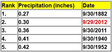
Second Driest September On Record. With a meager
.30" of rain (more than a trace fell on only 3 days this month)
September 2012 was the second driest ever recorded, second only to 1882.
Source:
Twin Cities NWS.
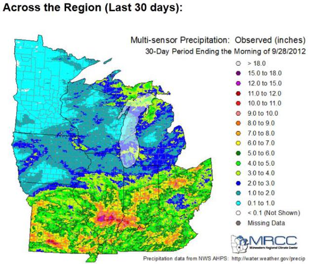
30 Day Rainfall. The contrast couldn't be any more
stark, a few tenths of an inch of rain for most of Minnesota, as much as
12-15" for central and southern Illinois (most of that from the sloppy
remains of "Isaac"). Map courtesy of the Midwestern Regional Climate
Center and the
Twin Cities National Weather Service.
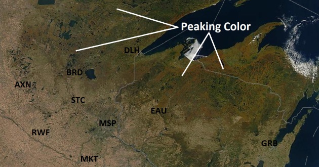
Drought - And Peak Color From Space. NASA's high-resolution
MODIS satellite image
from Saturday shows tinges of orange and red from low orbit. From 200
miles up you can see how dry much of Minnesota is right now.
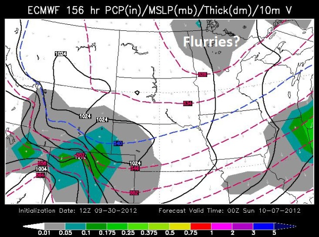
Insert Gasp Here. But Not Buying It (Yet). In the
spirit of full disclosure, warts and all, here is the 120 hour GFS
accumulated snowfall product, which prints out a cool foot of snow for
the Gunflint Trail and the BWCA, a plowable snow for Duluth and Hibbing
Thursday. I'm putting more stock and faith into the ECMWF (European)
solution, which hints at some slushy snow for northern Minnesota
Thursday, but not nearly this much. To some degree I'm covering my
meteorological-butt, but I suspect the odds of this happening are less
than 1 in 4.
Flurry Potential By Saturday Evening Up North?. With
850 mb temperatures (about 4,000 feet above the ground) forecast to be
in the 23-28 F range by Saturday I wouldn't be surprised to see
flurries, even a few heavier snow showers over northern Minnesota. I
don't see any snow flurries reaching the Twin Cities metro just yet. Map
above: WSI Corporation.
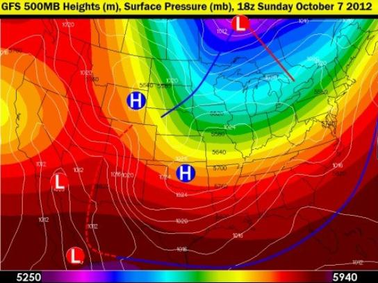
Looks Like October. The GFS 500 mb (18,000 foot)
forecast valid next Sunday at 1 pm shows a cold, deep trough of low
pressure centered over Hudson Bay, reinforcing "spokes" of energy
rotating around this cold whirlpool of Canadian air. By next Sunday
temperatures aloft may be marginally cold enough for a few wet flakes to
reach the ground up north.
Map above courtesy of Larry Cosgrove's
WeatherAmerica Newsletter.
Frost/Freeze possible Saturday morning, even for the close-in suburbs.
October 4. Mean date of the first 32-degree temperature in the Twin Cities. Source:
MN Climate Office.
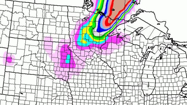
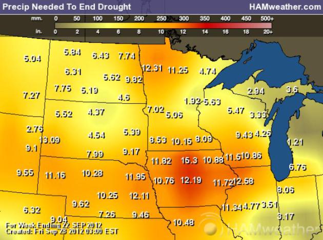
Rainfall Necessary To End The Drought. Based on
NOAA's Palmer Index, the values above are the rainfall amounts necessary
to end the drought. Those amounts range from 5-6" in the Twin Cities
metro to 8-11" over southern counties, to as much as 11-13" over the Red
River Valley. A couple of storms won't do the trick - it may take many
months to dig ourselves out of this dry, dusty hole. Map: NOAA, USDA and
Ham Weather.
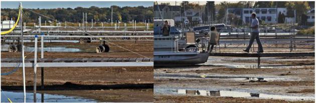
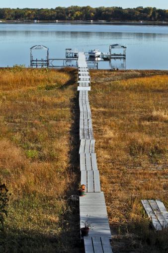
Good News For Dock Companies. Good grief - look at the collection of extendable docks on White Bear Lake. Details: "
White
Bear Lake is plummeting to a record low water level due to the current
drought and large amount of groundwater pumping. Docks along the
shoreline need to be constantly extended." (MARLIN LEVISON/STARTRIBUNE).
Groundwater Blamed In White Bear Lake Drop.
The Freshwater Society has a comprehensive article focused on some of the possible triggers of water loss in White Bear Lake; here's an excerpt: "
The
research, funded by the USGS, the state and a number of local
governmental units, reinforced some old theories and produced some new
evidence about the causes of the lake’s decline. The findings so far:
- White Bear drains a very small watershed and has always had
big decreases in area and volume during extended dry periods when
rainfall and melting snow do not keep up with evaporation.
- Chemical testing of water from wells around the lakes
confirms that lake water is flowing out the bottom of the lake into
groundwater aquifers that feed those wells.
- Pumping from high-capacity wells in suburban communities
that mostly draw their water from those aquifers more than doubled over
the last 30 years.
Statistical modeling suggests that the increased pumping is the
biggest cause, by far, of the lake’s decline, according to Perry Jones,
the USGS hydrologist who led the research. Other modeling predicts the
lake will drop further if there is no significant and sustained
increase in precipitation."
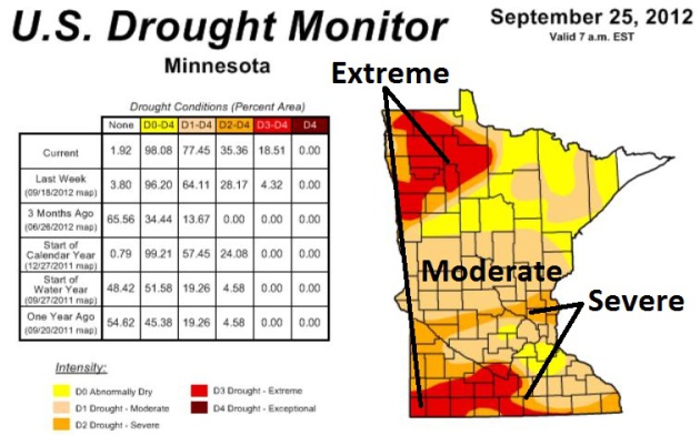
"...In total over 35 percent of Minnesota's landscape was
designated to be in severe or extreme drought, the largest fraction of
the state since the fall of 2006. The only Minnesota county not
designated to be drier than normal is Cook in the far northeast." - from Dr. Mark Seeley's WeatherTalk blog; details and links below.
One Of The Driest Septembers On Record. Actually,
it's the second driest September in modern-day records dating back to
1891, the driest since 1882 for MSP. Here's an excerpt of this week's
WeatherTalk blog post from Dr. Mark Seeley: "...
The
real story for September was the dryness due to absence of rainfall.
Many observers reported measurable rainfall amounts on only 2-3 days,
resulting in one of the driest Septembers in history on a statewide
basis. The driest September was 1952 when the statewide average
rainfall was just 0.57 inches. This year's statewide value will be
close to that one. Many observers clearly reported their driest
September in history, including Windom (0.30"), Moorhead (0.19"),
Willmar (0.14"), Collegeville (0.08"), and Morris (0.03"). For Morris
and Collegeville it was one of their driest months in history as well.....
As
of the end of September the U.S. Drought Monitor placed all or parts
of 45 Minnesota counties in severe to extreme drought, most notably in
southwestern, south-central and northwestern Minnesota."
Photo credit above: "
White Bear Lake is plummeting to a
record low water level due to the current drought and large amount of
groundwater pumping. Some lakeshore property owners have had to
constantly expand their docks to reach water's edge." (MARLIN LEVISON/STARTRIBUNE).
Minnesota's Drought Deepens. The latest
U.S. Drought Monitor
shows 98.08% of the Gopher State is now "abnormally dry", 77.45% of
Minnesota in moderate drought - severe drought now pushing across
central Minnesota into the northern suburbs of the Twin Cities. Extreme
drought is expanding across far southern Minnesota and much of the Red
River Valley. We started the year in serious drought - we will end 2012
in serious drought.
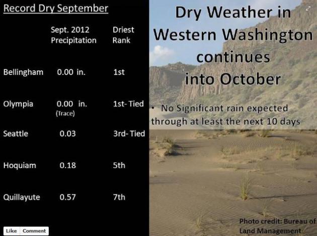
Record Dry September For Western Washington State. Dry weather is expanding west; here's an update from the Seattle office of the NWS via
Facebook: "
Dry
weather is expected to continue into October with no significant
precipitation through the next 10 days. Following a mostly dry August
western Washington had another very dry month. Many locations received
little to no rainfall and a few locations recorded their driest
September on record."
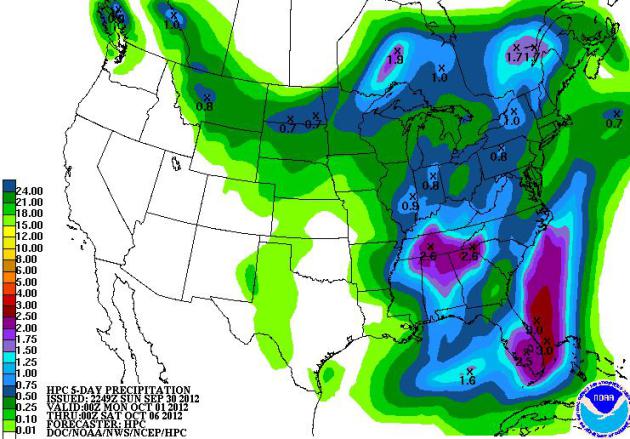
All or Nothing. NOAA HPC's 5-Day rainfall outlook
(QPF) is predicting significant 1-3" rains from The Mid South into south
Florida by Saturday; no rain expected from the Southern Plains to the
West Coast.
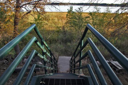
Expanding Drought - Exhibit A. There was a lake here
the last time I checked. This photo sums up the problem, which has
reached alarming levels at White Bear Lake: "
White Bear Lake is
plummeting to a record low water level due to the current drought and
large amount of groundwater pumping. Stairways that formerly led to
water's edge now end at a grassy beach." (MARLIN LEVISON/STARTRIBUNE).
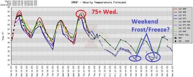
4 More Days Of Warmth - Then Reality. A clipper
cools us off slightly today (highs near 70 - somehow we'll cope). The
next (stronger) Alberta Clipper pulls warm air back into the state of
Minnesota Wednesday, before a temperature tumble on Thursday and Friday.
A few models are still showing frost/freeze conditions for much of the
metro by the weekend - right on schedule. The average (median) date for
the first 32 F. temperature in the Twin Cities is October 4. Graph: Iowa
State.
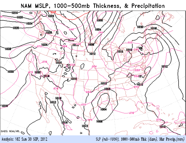
A Canadian Shove. The slow-moving storm responsible
for flooding rains from Texas into the Mid South will weaken as it
pushes northeast, spreading showers into the Ohio River Valley and
portions of the east. The big story will be a vigorous cold front
pushing south out of Canada into the Northern Rockies and Northern
Plains. By Friday there will be no question that autumn has arrived from
Pierre to Minneapolis/St. Paul to Madison and Chicago. NAM model data
above courtesy of NOAA.
Shorts and Jackets. You may be a little conflicted
when you stare at the clothes in your closet in the coming days. One
more day of shorts and T-shirts Wednesday, and then jackets and
sweatshirts stage a comeback by the end of the week; highs in the 40s
and low 50s Thursday into Sunday, followed by slow moderation early next
week. ECMWF forecast highs (red fonts) in Celsius.
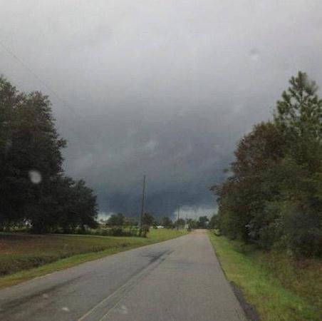
Possible Tornado. Here's an image of a possible
tornado "definite rotation with warned cell". Thanks to Derek Ladner via
@vince_webb for passing this along from Saucier, Mississippi Sunday.
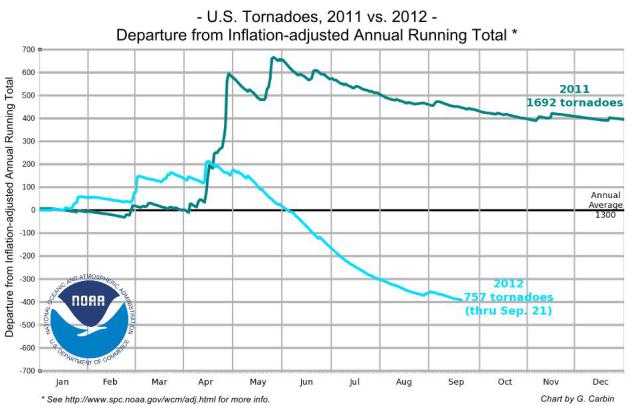
USA Could See Record Quiet Year For Tornadoes.
One silver lining to record heat and drought? No clouds, no wind shear,
no boundaries to spin up tornadic "supercells". Here's a clip from a
story at USA Today and
firstcoastnews.com: "
Following
on the heels of a deadly 2011, when almost 1,700 tornadoes killed 553
Americans, 2012 has been a remarkably quiet year for tornadoes across
the USA. "We may set an all-time record low for the year," says
meteorologist Harold Brooks of the National Severe Storms Laboratory in
Norman, Okla. So far this year, about 750 tornadoes have been reported
in the USA. At this time last year, about 1,500 had formed. An average
year, to date, has about 1,200 tornadoes, says Greg Carbin, warning
coordination meteorologist at the Storm Prediction Center in Norman."
Graphic: Greg Carbin, NOAA Storm Prediction Center.
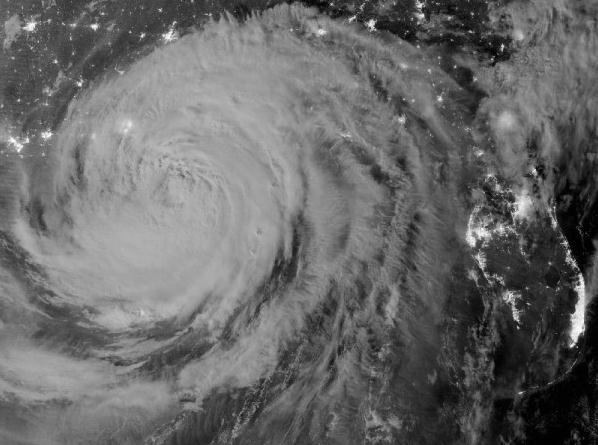
Hurricane Isaac Damaged 59,000 Homes In Louisiana, Officials Estimate.
Keep in mind Isaac was a Category 1 storm, but it stalled, prolonging
storm surge waves and torrential rains. Here's an excerpt from The
Times-Picayne at
nola.com: "
Hurricane Isaac
damaged nearly 59,000 homes as the slow-moving storm crawled across
southeast Louisiana, according to the latest damage estimates released
Friday. The Governor's Office of Homeland Security and Emergency
Preparedness said the most severe damage hit houses and rental units in St. John the Baptist and Plaquemines parishes,
where flooding swamped some homes with several feet of water. The
latest estimates -- 46,663 owner-occupied houses and 12,289 rental units
damaged by the storm -- were more than four times the preliminary
figures released a week after Isaac made landfall Aug. 28."
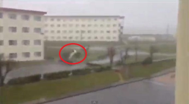
Car-Flipping Winds From Typhoon Jelawat. Here's a snippet of incredible
YouTube footage, courtesy of AP, as Typhoon Jelawat swept across Okinawa: "
A
powerful typhoon headed to Tokyo on Sunday after injuring dozens of
people, causing blackouts and paralyzing traffic in southern and western
Japan. Amateur video posted online on Saturday showed the winds
picking up a vehicle." (Sept. 30)
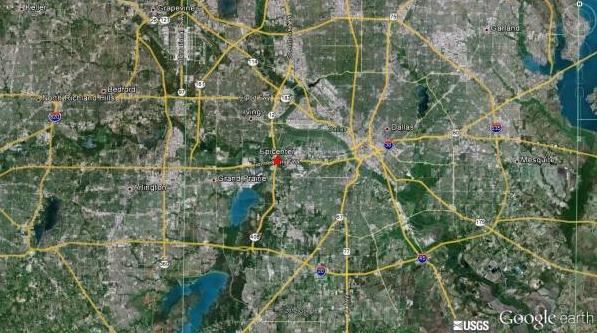
Two Earthquakes Confirmed In D/FW.
Texas Storm Chasers has more details on a rare Dallas tremor Sunday: "
Two
earthquakes, a M3.4 and a M3.1, were confirmed to have occured between
11:05 PM CDT and 11:10 PM CDT last night in western Dallas County. The
first earthquake occured in Irving off Highway 183 and the second
earthquake occured very close to Loop 12/Interstate 30. Very minor
damage has been reported with reports of small cracks in walls and a
few small items falling down. We do NOT specalize in earthquakes so we
cannot tell you if it occured due to fracking. We’ll leave that debate
up to the experts."
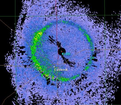
Ring Around The Doppler. What could produce such an
artifact? If you guessed "melting snow" you would be correct. You win
nothing, except the satisfaction of realizing that you're an
above-average weather geek (um...enthusiast). Details from the
Lubbock, Texas National Weather Service: "
A
curious RADAR display this morning - perhaps you can guess what caused
it. We call it a "bright band" and it typically shows up during cool
season stratiform rain. A hint: the altitude of the band varies
depending on how warm or cool the airmass is that the rain falls
through. This mornings bright band is around 8500 to 9000 feet above the
ground over the Texas South Plains - typical of an early fall tropical
airmass. We are looking at an approximate 9.9 degree elevation cut, as
opposed to the familiar 0.5 degree slice we normally look at. Could it
be either birds/insects flying off? How about an earthquake? Well, if
you guessed instead melting snow - then you are correct. As snowflakes
melt they add a layer of water onto the snow flakes and become highly
reflective within the melting layer (also very close to the freezing
level), thus causing a concentric ring around the RADAR dome location."
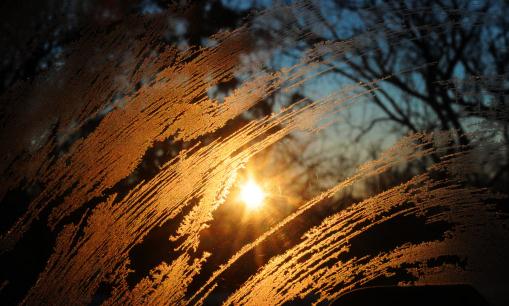
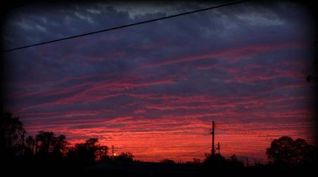
Autumnal Sunset. Thanks to Matt Crilley, who snapped
this photo of the setting sun illuminating a mid-level altocumulus
cloud deck over Waynesboro, Pennsylvania. Photo courtesy of
WeatherNation TV.
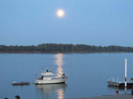
Harvest Moon. Brent Elkins snapped this photo of a Harvest Moon hovering above Paducah, Kentucky. Image courtesy of WeatherNation TV.
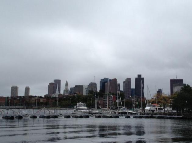
Boston Blues. WeatherNation TV meteorologist Bryan
Karrick snapped this photo in a cool, rainy Boston, where there is
little doubt that autumn has arrived.
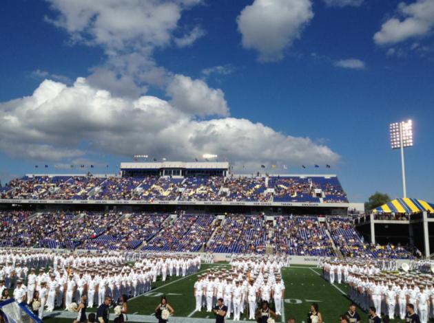
Football Weather. I was in Annapolis Saturday for a
Navy football game, a perfect sky filled with fair weather cumulus
overhead. The Navy Midshipmen lined up on the field before kick-off in
their white dress uniforms.
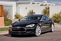
One Big Step For Tesla, One Giant Leap For E.V.'s.
I'm a car nut, and I have to admit that I love this car. It's the Tesla
Model S, made in America, all electric, all the time. Will
electric-powered vehicles catch on over time? Here's an excerpt of a
fairly glowing review from
The New York Times: "
AUTOMAKERS
have a favored buzzword for promoting important new models:
game-changer. Excuse me, but the game is not so easily changed. Put
simply, the automobile has not undergone a fundamental change in design
or use since Henry Ford rolled out the Model T more than a century
ago. At least that’s what I thought until I spent a week with the Tesla
Model S. The 2012 Model S, a versatile sedan that succeeds the
company’s two-seat Roadster, is simultaneously stylish, efficient,
roomy, crazy fast, high-tech and all electric. It defies the notion
that electric cars are range-limited conveyances."
Photo credit:
Wikipedia (which has more details on this EV).
Twitter is 'gonna be HUGE!
Words of Wisdom. Thanks to
someecards.com and my sister, Joan, who is German, so she can almost get away with sharing this. "Ich liebe dich!" How romantic.
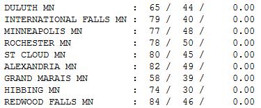
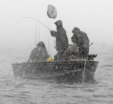
Plenty Warm. A light east breeze kept the Twin
Cities a few degrees cooler yesterday, "only" in the upper 70s.
Statewide highs ranged from 58 at Grand Marais to 65 Duluth, 78
Rochester, 80 St. Cloud and 84 Redwood Falls.
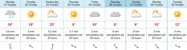
Paul's Conservation Minnesota Outlook for the Twin Cities and all of Minnesota:
MONDAY: More clouds, brief shower possible. Winds: N 10-20. High: near 70
MONDAY NIGHT: Partial clearing. Low: 49
TUESDAY: Mild sun, very pleasant. High: 72
WEDNESDAY: Fading sun, last lukewarm day. Low: 52. High: 76
THURSDAY: Gusty with showers (mixing with wet
snow over northern Minnesota, where a slushy accumulation is possible).
Turning colder. Low: 50. High: 52
FRIDAY: Chilly with more clouds than sun - light jackets return. Low: 37. High: 50
SATURDAY: Metro frost possible. Mix of clouds and sun. Few flakes far north! Low: 32. High: 49
SUNDAY: More sun, less wind. Brisk. Low: 34. High: 52
Our SUPER-SIZED Minnesota Summer
Definition of an optimist: Minnesotan with a
swimming pool. Or a convertible. "Summers in Minnesota are lovely. I
just wish they lasted more than a week or two" my Pennsylvania father
jokes. Think again. There were boats on the lake in late March - there
will be boating in October. If this autumn is similar to the last 10
it'll be warm enough for golf into early November.
We're losing our Cold Weather Mojo. Longer
growing season - check. Fewer subzero blasts - check. Nights trending
warmer - check. This slow-motion warming trend has some unpleasant side
effects, but Minnesota will benefit, overall. That's my extended outlook.
Assuming we can keep water in our lakes, of
course. It was the driest September since 1882, and I still don't see a
buckling of jet stream winds that would spray a firehose of Gulf
moisture northward.
A fizzling clipper sparks a stray shower today.
Highs top 70 into Wednesday; a stronger surge of chilly air triggers
showery rains on Thursday, possibly changing to slushy wet snow north of Duluth. If skies clear the metro may see a frost
early Saturday, with a few flurries up north.
Yes, that may be it for 80s this year, but expect more 60s by mid-October.
Wait, if this keeps up my dad may move out here.
Uh oh.
Climate Stories...
High Arctic Warming Exceeds Viking Era. The story from
The Current; here's a snippet: "
Temperatures
high in the Norwegian Arctic are above those in a natural warm period
in Viking times, underscoring a thaw opening the region to everything
from oil exploration to shipping, scientists said on Thursday. Last
week, sea ice on the Arctic Ocean set a record low since satellite
observations began in the 1970s. In recent years, mussels have been
found off the Norwegian archipelago of Svalbard for the first time since
the Viking era 1,000 years ago. The study showed that summertime
temperatures on Svalbard were higher now than at any time in the past
1,800 years, including in the Medieval Warm Period from 950 to 1200,
scientists wrote in the journal Geology."
Fish To Shrink By Up To A Quarter Due To Climate Change, Study Reveals. Here's the introduction to a story at
The Guardian. Smaller fish in a warming world? "
Global
warming is likely to shrink the size of fish by as much as a quarter
in coming decades, according to a groundbreaking new study of the
world's oceans.
The reduction in individual fish size will be matched by a dwindling
of overall fish stocks, warned scientists, at a time when the world's
growing human population is putting ever greater pressure on fisheries."
"We Don't Know Enough About Climate Change Yet."
I agree with some of what this Forbes Op-Ed author has to say - he's
right: we don't know what all the various feedbacks will be; they may be
better (or worse) than predicted. He's advocating a carbon tax, but he
also talks about environmental activists wanting to "dismantle
capitalism". Not sure where that meme comes from, but I hear it a lot.
"This climate change baloney is just a clever way to redistribute wealth
and turn the USA into something (with socialistic leanings) that
resembles Spain or Greece." Really? The innovation required to mitigate
climate change will propel the USA into a new technological orbit, one
that will insure our success and competitive domination for most of the
21st century. This is what (most) politicians and policy wonks fail to
realize. This is another Moon Shot for the USA. One that calls for
innovation and new technological solutions that will generate millions
of new (American) jobs and give us a sustainable competitive edge. If we
can get past denial and get to solutions. The remains to be seen.
Here's an excerpt of the
Forbest Op-Ed that caught my eye: "..
.We
don’t, as yet, know what the interaction of all of the feedbacks from
climate change will be. We know that some such feedbacks will be
positive, we know that others will be negative. We’re not wholly and
entirely sure whether the total effect of them all will be positive and
negative: although we’re pretty sure that the total will be positive.
We are most certainly not sure that the effects of climate change will
be bad enough that we should dismantle industrial capitalism to avoid
it: whatever certain activists might tell you about it all...."
Are We Wrong About Climate Change? Here's an excerpt from a Doug Craig
Climate of Change post at redding.com: "...
So
if the science is settled, why do so many have trouble believing this?
As Oreskes explains, "The mass media have paid a great deal of
attention to a handful of dissenters in a manner that is greatly
disproportionate with their representation in the scientific community.
The number of climate scientists who actively do research in the field
but disagree with the consensus position is evidently very small."
"This is not to say that there are not a significant
number of contrarians but to point out that most of them are not climate
scientists and therefore have little (or no) basis to claim to be
experts on the subjects on which they boldly pronounce."
Climate Change Is Already Damaging World's Economy. The story from The Guardian and
Climate Central; here's an excerpt: "
Climate
change is already contributing to the deaths of nearly 400,000 people a
year and costing the world more than $1.2 trillion, wiping 1.6 percent
annually from global GDP, according to a new study. The impacts are
being felt most keenly in developing countries, according to the
research, where damage to agricultural production from extreme weather
linked to climate change is contributing to deaths from malnutrition,
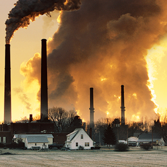
poverty, and their associated diseases. Air pollution caused by the use
of fossil fuels is also separately contributing to the deaths of at
least 4.5 million people a year, the report found."
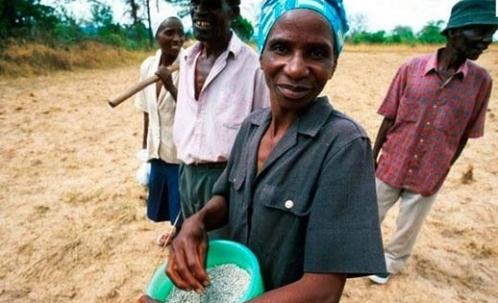
Photo credit above: "
Impacts
of climate change are mostly keenly felt in developing countries where
damage to agricultural production from extreme weather is contributing
to deaths from malnutrition, poverty and their associated diseases." Credit: NEWSCOM.
When Will Candidates Address Climate Change? Here's an excerpt of an Op-Ed at
delawareonline.com: "...
A
study published last year by scientists at Stanford and MIT reported
that chemically removing carbon dioxide from the atmosphere would cost
about $1,000 a ton. That means it would cost $600
trillion to remove 600 billion tons, and we’re increasing our
“environmental debt” by more than $30 trillion a year! Those numbers
can be compared to the 2011 world GDP of about $70 trillion.As Hansen said: “The era of doubts, delays and denial, of ineffectual half-measures, must end...."
Photo credit above:
politico.com.
Species Loss Creates More Climate Change Sensitivity. Here's the intro to an interesting story at
Sci-Tech Today: "
Climate
change can exacerbate the negative effects of losing sensitive
species, researchers say. Biodiversity acts as an insurance policy as
it increases the likelihood at least some species will be sufficiently
resilient to sustain important functions such as water purification and
crop pollination in a changing environment. Species loss and
reduced biodiversity make nature more sensitive to climate change,
Swedish researchers say. This is especially true for species that
sustain important functions such as water purification and crop
pollination in a changing environment, they said."


No comments:
Post a Comment